 Note:
The expiration time in the watch graphic is amended if the watch is
replaced, cancelled or extended.
Note:
Note:
The expiration time in the watch graphic is amended if the watch is
replaced, cancelled or extended.
Note: Click for
Watch Status Reports.
SEL2
URGENT - IMMEDIATE BROADCAST REQUESTED
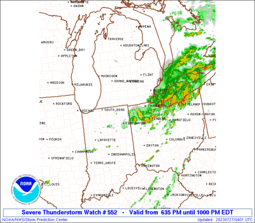
Severe Thunderstorm Watch Number 552
NWS Storm Prediction Center Norman OK
635 PM EDT Wed Jul 26 2023
The NWS Storm Prediction Center has issued a
* Severe Thunderstorm Watch for portions of
Northeast Indiana
Southeast Lower Michigan
Northwest Ohio
Lake Erie
* Effective this Wednesday evening from 635 PM until 1000 PM EDT.
* Primary threats include...
Scattered damaging wind gusts to 70 mph possible
A tornado or two possible
SUMMARY...A small cluster has recently organized along the trailing
outflow from an earlier MCS and may persist east-southeast in the
Indiana/Michigan/Ohio border area for a few hours this evening.
The severe thunderstorm watch area is approximately along and 30
statute miles north and south of a line from 115 miles west of
Toledo OH to 45 miles east of Toledo OH. For a complete depiction of
the watch see the associated watch outline update (WOUS64 KWNS
WOU2).
PRECAUTIONARY/PREPAREDNESS ACTIONS...
REMEMBER...A Severe Thunderstorm Watch means conditions are
favorable for severe thunderstorms in and close to the watch area.
Persons in these areas should be on the lookout for threatening
weather conditions and listen for later statements and possible
warnings. Severe thunderstorms can and occasionally do produce
tornadoes.
&&
OTHER WATCH INFORMATION...CONTINUE...WW 551...
AVIATION...A few severe thunderstorms with hail surface and aloft to
0.5 inches. Extreme turbulence and surface wind gusts to 60 knots. A
few cumulonimbi with maximum tops to 500. Mean storm motion vector
28035.
...Grams
 Note:
The Aviation Watch (SAW) product is an approximation to the watch area.
The actual watch is depicted by the shaded areas.
Note:
The Aviation Watch (SAW) product is an approximation to the watch area.
The actual watch is depicted by the shaded areas.
   SAW2
   WW 552 SEVERE TSTM IN MI OH LE 262235Z - 270200Z
   AXIS..30 STATUTE MILES NORTH AND SOUTH OF LINE..
   115W TOL/TOLEDO OH/ - 45E TOL/TOLEDO OH/
   ..AVIATION COORDS.. 25NM N/S /18SE GIJ - 43SSE DXO/
   HAIL SURFACE AND ALOFT..0.5 INCH. WIND GUSTS..60 KNOTS.
   MAX TOPS TO 500. MEAN STORM MOTION VECTOR 28035.

   LAT...LON 41998602 42018293 41148293 41128602

   THIS IS AN APPROXIMATION TO THE WATCH AREA.  FOR A
   COMPLETE DEPICTION OF THE WATCH SEE WOUS64 KWNS
   FOR WOU2.
Watch 552 Status Report Messages:
STATUS REPORT #2 ON WW 552

VALID 270120Z - 270240Z

THE SEVERE WEATHER THREAT CONTINUES ACROSS THE ENTIRE WATCH AREA.

..SPC..07/27/23

ATTN...WFO...IWX...GRR...DTX...CLE...

&&

STATUS REPORT FOR WS 552

SEVERE WEATHER THREAT CONTINUES FOR THE FOLLOWING AREAS

INC033-039-085-087-113-151-270240-

IN
.    INDIANA COUNTIES INCLUDED ARE

DE KALB 	     ELKHART		 KOSCIUSKO
LAGRANGE	     NOBLE		 STEUBEN
$$


MIC059-075-091-115-270240-

MI
.    MICHIGAN COUNTIES INCLUDED ARE

HILLSDALE	     JACKSON		 LENAWEE
MONROE
$$


OHC039-051-069-095-123-143-171-173-270240-

OH
.    OHIO COUNTIES INCLUDED ARE

DEFIANCE	     FULTON		 HENRY
LUCAS		     OTTAWA		 SANDUSKY
WILLIAMS	     WOOD
$$


LEZ142-143-162-163-444-270240-

CW

.    ADJACENT COASTAL WATERS INCLUDED ARE

MAUMEE BAY TO RENO BEACH OH

RENO BEACH TO THE ISLANDS OH

DETROIT RIVER LT. TO MAUMEE BAY OH TO RENO BEACH OH BEYOND 5NM
OFFSHORELINE TO US-CANADIAN BORDER

RENO BEACH TO THE ISLANDS OH BEYOND 5NM OFF SHORELINE TO
US-CANADIAN BORDER

MICHIGAN WATERS OF LAKE ERIE FROM DETROIT RIVER TO NORTH CAPE MI

$$
THE WATCH STATUS MESSAGE IS FOR GUIDANCE PURPOSES ONLY.  PLEASE
REFER TO WATCH COUNTY NOTIFICATION STATEMENTS FOR OFFICIAL
INFORMATION ON COUNTIES...INDEPENDENT CITIES AND MARINE ZONES
CLEARED FROM SEVERE THUNDERSTORM AND TORNADO WATCHES.
$$

STATUS REPORT #1 ON WW 552

VALID 270025Z - 270140Z

THE SEVERE WEATHER THREAT CONTINUES ACROSS THE ENTIRE WATCH AREA.

..SPC..07/27/23

ATTN...WFO...IWX...GRR...DTX...CLE...

&&

STATUS REPORT FOR WS 552

SEVERE WEATHER THREAT CONTINUES FOR THE FOLLOWING AREAS

INC033-039-085-087-113-151-270140-

IN
.    INDIANA COUNTIES INCLUDED ARE

DE KALB 	     ELKHART		 KOSCIUSKO
LAGRANGE	     NOBLE		 STEUBEN
$$


MIC059-075-091-115-270140-

MI
.    MICHIGAN COUNTIES INCLUDED ARE

HILLSDALE	     JACKSON		 LENAWEE
MONROE
$$


OHC039-051-069-095-123-143-171-173-270140-

OH
.    OHIO COUNTIES INCLUDED ARE

DEFIANCE	     FULTON		 HENRY
LUCAS		     OTTAWA		 SANDUSKY
WILLIAMS	     WOOD
$$


LEZ142-143-162-163-444-270140-

CW

.    ADJACENT COASTAL WATERS INCLUDED ARE

MAUMEE BAY TO RENO BEACH OH

RENO BEACH TO THE ISLANDS OH

DETROIT RIVER LT. TO MAUMEE BAY OH TO RENO BEACH OH BEYOND 5NM
OFFSHORELINE TO US-CANADIAN BORDER

RENO BEACH TO THE ISLANDS OH BEYOND 5NM OFF SHORELINE TO
US-CANADIAN BORDER

MICHIGAN WATERS OF LAKE ERIE FROM DETROIT RIVER TO NORTH CAPE MI

$$
THE WATCH STATUS MESSAGE IS FOR GUIDANCE PURPOSES ONLY.  PLEASE
REFER TO WATCH COUNTY NOTIFICATION STATEMENTS FOR OFFICIAL
INFORMATION ON COUNTIES...INDEPENDENT CITIES AND MARINE ZONES
CLEARED FROM SEVERE THUNDERSTORM AND TORNADO WATCHES.
$$
Note:
Click for Complete Product Text.
Tornadoes
Probability of 2 or more tornadoes
|
Low (20%)
|
Probability of 1 or more strong (EF2-EF5) tornadoes
|
Low (5%)
|
Wind
Probability of 10 or more severe wind events
|
Mod (40%)
|
Probability of 1 or more wind events > 65 knots
|
Low (20%)
|
Hail
Probability of 10 or more severe hail events
|
Low (<5%)
|
Probability of 1 or more hailstones > 2 inches
|
Low (<5%)
|
Combined Severe Hail/Wind
Probability of 6 or more combined severe hail/wind events
|
Mod (50%)
|
For each watch, probabilities for particular events inside the watch
(listed above in each table) are determined by the issuing forecaster.
The "Low" category contains probability values ranging from less than 2%
to 20% (EF2-EF5 tornadoes), less than 5% to 20% (all other probabilities),
"Moderate" from 30% to 60%, and "High" from 70% to greater than 95%.
High values are bolded and lighter in color to provide awareness of
an increased threat for a particular event.


 @NWSSPC


