 Note:
The expiration time in the watch graphic is amended if the watch is
replaced, cancelled or extended.
Note:
Note:
The expiration time in the watch graphic is amended if the watch is
replaced, cancelled or extended.
Note: Click for
Watch Status Reports.
SEL3
URGENT - IMMEDIATE BROADCAST REQUESTED
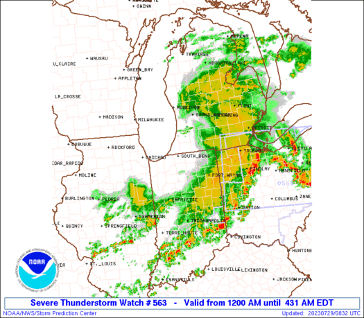
Severe Thunderstorm Watch Number 563
NWS Storm Prediction Center Norman OK
1200 AM EDT Sat Jul 29 2023
The NWS Storm Prediction Center has issued a
* Severe Thunderstorm Watch for portions of
Northern Indiana
Southwest Lower Michigan
Northwest Ohio
Lake Michigan
* Effective this Saturday morning from Midnight until 500 AM EDT.
* Primary threats include...
Scattered damaging wind gusts to 65 mph possible
SUMMARY...Multiple thunderstorm complexes will rapidly spread
east-southeast across the region before dawn, with the greatest
threat for damaging winds across the northern Indiana vicinity.
The severe thunderstorm watch area is approximately along and 65
statute miles east and west of a line from 30 miles north northwest
of Grand Rapids MI to 25 miles west southwest of Muncie IN. For a
complete depiction of the watch see the associated watch outline
update (WOUS64 KWNS WOU3).
PRECAUTIONARY/PREPAREDNESS ACTIONS...
REMEMBER...A Severe Thunderstorm Watch means conditions are
favorable for severe thunderstorms in and close to the watch area.
Persons in these areas should be on the lookout for threatening
weather conditions and listen for later statements and possible
warnings. Severe thunderstorms can and occasionally do produce
tornadoes.
&&
OTHER WATCH INFORMATION...CONTINUE...WW 560...WW 561...WW 562...
AVIATION...A few severe thunderstorms with hail surface and aloft to
1 inch. Extreme turbulence and surface wind gusts to 55 knots. A few
cumulonimbi with maximum tops to 550. Mean storm motion vector
29050.
...Grams
SEL3
URGENT - IMMEDIATE BROADCAST REQUESTED
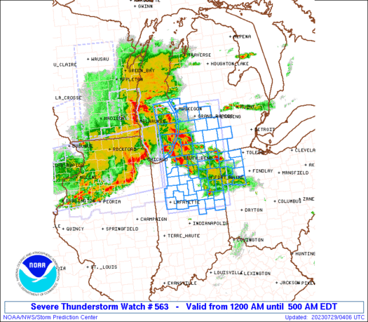
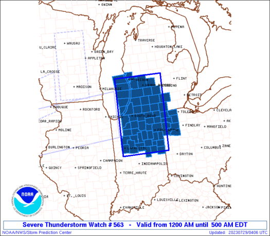
Severe Thunderstorm Watch Number 563
NWS Storm Prediction Center Norman OK
1200 AM EDT Sat Jul 29 2023
The NWS Storm Prediction Center has issued a
* Severe Thunderstorm Watch for portions of
Northern Indiana
Southwest Lower Michigan
Northwest Ohio
Lake Michigan
* Effective this Saturday morning from Midnight until 500 AM EDT.
* Primary threats include...
Scattered damaging wind gusts to 65 mph possible
SUMMARY...Multiple thunderstorm complexes will rapidly spread
east-southeast across the region before dawn, with the greatest
threat for damaging winds across the northern Indiana vicinity.
The severe thunderstorm watch area is approximately along and 65
statute miles east and west of a line from 30 miles north northwest
of Grand Rapids MI to 25 miles west southwest of Muncie IN. For a
complete depiction of the watch see the associated watch outline
update (WOUS64 KWNS WOU3).
PRECAUTIONARY/PREPAREDNESS ACTIONS...
REMEMBER...A Severe Thunderstorm Watch means conditions are
favorable for severe thunderstorms in and close to the watch area.
Persons in these areas should be on the lookout for threatening
weather conditions and listen for later statements and possible
warnings. Severe thunderstorms can and occasionally do produce
tornadoes.
&&
OTHER WATCH INFORMATION...CONTINUE...WW 560...WW 561...WW 562...
AVIATION...A few severe thunderstorms with hail surface and aloft to
1 inch. Extreme turbulence and surface wind gusts to 55 knots. A few
cumulonimbi with maximum tops to 550. Mean storm motion vector
29050.
...Grams
 Note:
The Aviation Watch (SAW) product is an approximation to the watch area.
The actual watch is depicted by the shaded areas.
Note:
The Aviation Watch (SAW) product is an approximation to the watch area.
The actual watch is depicted by the shaded areas.
   SAW3
   WW 563 SEVERE TSTM IN MI OH LM 290400Z - 290900Z
   AXIS..65 STATUTE MILES EAST AND WEST OF LINE..
   30NNW GRR/GRAND RAPIDS MI/ - 25WSW MIE/MUNCIE IN/
   ..AVIATION COORDS.. 55NM E/W /14ENE MKG - 30NE IND/
   HAIL SURFACE AND ALOFT..1 INCH. WIND GUSTS..55 KNOTS.
   MAX TOPS TO 550. MEAN STORM MOTION VECTOR 29050.

   LAT...LON 43278446 40098461 40098707 43278704

   THIS IS AN APPROXIMATION TO THE WATCH AREA.  FOR A
   COMPLETE DEPICTION OF THE WATCH SEE WOUS64 KWNS
   FOR WOU3.
Watch 563 Status Report Messages:
STATUS REPORT #2 ON WW 563

VALID 290740Z - 290840Z

SEVERE WEATHER THREAT CONTINUES RIGHT OF A LINE FROM 25 SW MIE TO
20 E FWA TO 15 ESE JXN.

..BROYLES..07/29/23

ATTN...WFO...IWX...IND...GRR...

&&

STATUS REPORT FOR WS 563

SEVERE WEATHER THREAT CONTINUES FOR THE FOLLOWING AREAS

INC001-035-075-135-290840-

IN
.    INDIANA COUNTIES INCLUDED ARE

ADAMS		     DELAWARE		 JAY
RANDOLPH
$$


OHC003-039-051-069-125-137-161-290840-

OH
.    OHIO COUNTIES INCLUDED ARE

ALLEN		     DEFIANCE		 FULTON
HENRY		     PAULDING		 PUTNAM
VAN WERT
$$


THE WATCH STATUS MESSAGE IS FOR GUIDANCE PURPOSES ONLY.  PLEASE
REFER TO WATCH COUNTY NOTIFICATION STATEMENTS FOR OFFICIAL
INFORMATION ON COUNTIES...INDEPENDENT CITIES AND MARINE ZONES
CLEARED FROM SEVERE THUNDERSTORM AND TORNADO WATCHES.
$$

STATUS REPORT #1 ON WW 563

VALID 290635Z - 290740Z

SEVERE WEATHER THREAT CONTINUES RIGHT OF A LINE FROM 15 WNW LAF
TO 40 SSE SBN TO 5 SSW AZO TO 35 ENE MKG.

..BROYLES..07/29/23

ATTN...WFO...IWX...IND...GRR...

&&

STATUS REPORT FOR WS 563

SEVERE WEATHER THREAT CONTINUES FOR THE FOLLOWING AREAS

INC001-003-009-015-017-023-033-035-039-049-053-067-069-075-085-
087-095-103-113-135-151-157-159-169-179-181-183-290740-

IN
.    INDIANA COUNTIES INCLUDED ARE

ADAMS		     ALLEN		 BLACKFORD
CARROLL 	     CASS		 CLINTON
DE KALB 	     DELAWARE		 ELKHART
FULTON		     GRANT		 HOWARD
HUNTINGTON	     JAY		 KOSCIUSKO
LAGRANGE	     MADISON		 MIAMI
NOBLE		     RANDOLPH		 STEUBEN
TIPPECANOE	     TIPTON		 WABASH
WELLS		     WHITE		 WHITLEY
$$


MIC015-023-025-045-059-067-075-077-081-149-290740-

MI
.    MICHIGAN COUNTIES INCLUDED ARE

BARRY		     BRANCH		 CALHOUN
EATON		     HILLSDALE		 IONIA
JACKSON 	     KALAMAZOO		 KENT
ST. JOSEPH
$$


OHC003-039-051-069-125-137-161-171-290740-

OH
.    OHIO COUNTIES INCLUDED ARE

ALLEN		     DEFIANCE		 FULTON
HENRY		     PAULDING		 PUTNAM
VAN WERT	     WILLIAMS
$$


THE WATCH STATUS MESSAGE IS FOR GUIDANCE PURPOSES ONLY.  PLEASE
REFER TO WATCH COUNTY NOTIFICATION STATEMENTS FOR OFFICIAL
INFORMATION ON COUNTIES...INDEPENDENT CITIES AND MARINE ZONES
CLEARED FROM SEVERE THUNDERSTORM AND TORNADO WATCHES.
$$
Note:
Click for Complete Product Text.
Tornadoes
Probability of 2 or more tornadoes
|
Low (10%)
|
Probability of 1 or more strong (EF2-EF5) tornadoes
|
Low (<2%)
|
Wind
Probability of 10 or more severe wind events
|
Mod (40%)
|
Probability of 1 or more wind events > 65 knots
|
Low (20%)
|
Hail
Probability of 10 or more severe hail events
|
Low (10%)
|
Probability of 1 or more hailstones > 2 inches
|
Low (10%)
|
Combined Severe Hail/Wind
Probability of 6 or more combined severe hail/wind events
|
Mod (60%)
|
For each watch, probabilities for particular events inside the watch
(listed above in each table) are determined by the issuing forecaster.
The "Low" category contains probability values ranging from less than 2%
to 20% (EF2-EF5 tornadoes), less than 5% to 20% (all other probabilities),
"Moderate" from 30% to 60%, and "High" from 70% to greater than 95%.
High values are bolded and lighter in color to provide awareness of
an increased threat for a particular event.


 @NWSSPC


