 Note:
The expiration time in the watch graphic is amended if the watch is
replaced, cancelled or extended.
Note:
Note:
The expiration time in the watch graphic is amended if the watch is
replaced, cancelled or extended.
Note: Click for
Watch Status Reports.
SEL6
URGENT - IMMEDIATE BROADCAST REQUESTED
Severe Thunderstorm Watch Number 656
NWS Storm Prediction Center Norman OK
635 PM EDT Thu Aug 24 2023
The NWS Storm Prediction Center has issued a
* Severe Thunderstorm Watch for portions of
Central and Southern Lower Michigan
Lake Erie
Lake Huron
Lake Michigan
* Effective this Thursday night and Friday morning from 635 PM
until 100 AM EDT.
* Primary threats include...
Scattered damaging winds likely with isolated significant gusts
to 85 mph possible
Scattered large hail and isolated very large hail events to 2
inches in diameter possible
A tornado or two possible
SUMMARY...Thunderstorms will intensify across western Lower Michigan
this evening and spread eastward across the watch area. Strong to
intense wind gusts will be possible with the stronger cells, along
with large hail. A tornado or two is also possible with any
supercells that can form.
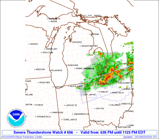
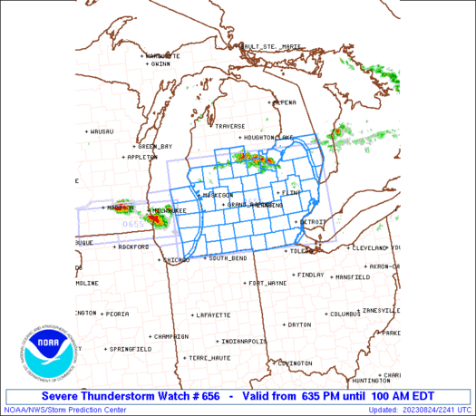
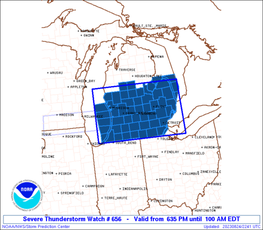
The severe thunderstorm watch area is approximately along and 80
statute miles north and south of a line from 50 miles west southwest
of Muskegon MI to 35 miles east northeast of Mount Clemens MI. For a
complete depiction of the watch see the associated watch outline
update (WOUS64 KWNS WOU6).
PRECAUTIONARY/PREPAREDNESS ACTIONS...
REMEMBER...A Severe Thunderstorm Watch means conditions are
favorable for severe thunderstorms in and close to the watch area.
Persons in these areas should be on the lookout for threatening
weather conditions and listen for later statements and possible
warnings. Severe thunderstorms can and occasionally do produce
tornadoes.
&&
OTHER WATCH INFORMATION...CONTINUE...WW 654...WW 655...
AVIATION...A few severe thunderstorms with hail surface and aloft to
2 inches. Extreme turbulence and surface wind gusts to 75 knots. A
few cumulonimbi with maximum tops to 500. Mean storm motion vector
28030.
...Hart
   SEL6

   URGENT - IMMEDIATE BROADCAST REQUESTED
   Severe Thunderstorm Watch Number 656
   NWS Storm Prediction Center Norman OK
   635 PM EDT Thu Aug 24 2023

   The NWS Storm Prediction Center has issued a

   * Severe Thunderstorm Watch for portions of
     Central and Southern Lower Michigan
     Lake Erie
     Lake Huron
     Lake Michigan

   * Effective this Thursday night and Friday morning from 635 PM
     until 100 AM EDT.

   * Primary threats include...
     Scattered damaging winds likely with isolated significant gusts
       to 85 mph possible
     Scattered large hail and isolated very large hail events to 2
       inches in diameter possible
     A tornado or two possible

   SUMMARY...Thunderstorms will intensify across western Lower Michigan
   this evening and spread eastward across the watch area.  Strong to
   intense wind gusts will be possible with the stronger cells, along
   with large hail.  A tornado or two is also possible with any
   supercells that can form.

   The severe thunderstorm watch area is approximately along and 80
   statute miles north and south of a line from 50 miles west southwest
   of Muskegon MI to 35 miles east northeast of Mount Clemens MI. For a
   complete depiction of the watch see the associated watch outline
   update (WOUS64 KWNS WOU6).

   PRECAUTIONARY/PREPAREDNESS ACTIONS...

   REMEMBER...A Severe Thunderstorm Watch means conditions are
   favorable for severe thunderstorms in and close to the watch area.
   Persons in these areas should be on the lookout for threatening
   weather conditions and listen for later statements and possible
   warnings. Severe thunderstorms can and occasionally do produce
   tornadoes.

   &&

   OTHER WATCH INFORMATION...CONTINUE...WW 654...WW 655...

   AVIATION...A few severe thunderstorms with hail surface and aloft to
   2 inches. Extreme turbulence and surface wind gusts to 75 knots. A
   few cumulonimbi with maximum tops to 500. Mean storm motion vector
   28030.

   ...Hart
 Note:
The Aviation Watch (SAW) product is an approximation to the watch area.
The actual watch is depicted by the shaded areas.
Note:
The Aviation Watch (SAW) product is an approximation to the watch area.
The actual watch is depicted by the shaded areas.
   SAW6
   WW 656 SEVERE TSTM MI LE LH LM 242235Z - 250500Z
   AXIS..80 STATUTE MILES NORTH AND SOUTH OF LINE..
   50WSW MKG/MUSKEGON MI/ - 35ENE MTC/MOUNT CLEMENS MI/
   ..AVIATION COORDS.. 70NM N/S /51WSW MKG - 36SE ECK/
   HAIL SURFACE AND ALOFT..2 INCHES. WIND GUSTS..75 KNOTS.
   MAX TOPS TO 500. MEAN STORM MOTION VECTOR 28030.

   LAT...LON 44058714 43958219 41638219 41738714

   THIS IS AN APPROXIMATION TO THE WATCH AREA.  FOR A
   COMPLETE DEPICTION OF THE WATCH SEE WOUS64 KWNS
   FOR WOU6.
Watch 656 Status Report Messages:
STATUS REPORT #3 ON WW 656

VALID 250230Z - 250340Z

SEVERE WEATHER THREAT CONTINUES RIGHT OF A LINE FROM 25 ESE SBN
TO 20 WSW JXN TO 20 NNW ARB TO 10 ENE FNT TO 35 S BAX TO 20 N MTC
TO 40 ENE MTC.

..THORNTON..08/25/23

ATTN...WFO...GRR...DTX...IWX...

&&

STATUS REPORT FOR WS 656

SEVERE WEATHER THREAT CONTINUES FOR THE FOLLOWING AREAS

MIC023-059-075-087-091-099-115-125-161-163-250340-

MI
.    MICHIGAN COUNTIES INCLUDED ARE

BRANCH		     HILLSDALE		 JACKSON
LAPEER		     LENAWEE		 MACOMB
MONROE		     OAKLAND		 WASHTENAW
WAYNE
$$


LCZ423-460-LEZ444-250340-

CW

.    ADJACENT COASTAL WATERS INCLUDED ARE

DETROIT RIVER

LAKE ST. CLAIR OPEN LAKE (U.S. PORTION)

MICHIGAN WATERS OF LAKE ERIE FROM DETROIT RIVER TO NORTH CAPE MI

$$
THE WATCH STATUS MESSAGE IS FOR GUIDANCE PURPOSES ONLY.  PLEASE
REFER TO WATCH COUNTY NOTIFICATION STATEMENTS FOR OFFICIAL
INFORMATION ON COUNTIES...INDEPENDENT CITIES AND MARINE ZONES
CLEARED FROM SEVERE THUNDERSTORM AND TORNADO WATCHES.
$$

STATUS REPORT #2 ON WW 656

VALID 250035Z - 250140Z

SEVERE WEATHER THREAT CONTINUES RIGHT OF A LINE FROM 50 WNW MKG
TO 35 ENE MKG TO 15 W MBS TO 15 SSE BAX TO 50 ENE BAX.

FOR ADDITIONAL INFORMATION SEE MESOSCALE DISCUSSION 2041

..THORNTON..08/25/23

ATTN...WFO...GRR...DTX...IWX...

&&

STATUS REPORT FOR WS 656

SEVERE WEATHER THREAT CONTINUES FOR THE FOLLOWING AREAS

MIC005-015-021-023-025-027-037-045-049-057-059-065-067-075-077-
081-087-091-093-099-115-117-121-125-139-145-147-149-151-155-157-
159-161-163-250140-

MI
.    MICHIGAN COUNTIES INCLUDED ARE

ALLEGAN 	     BARRY		 BERRIEN
BRANCH		     CALHOUN		 CASS
CLINTON 	     EATON		 GENESEE
GRATIOT 	     HILLSDALE		 INGHAM
IONIA		     JACKSON		 KALAMAZOO
KENT		     LAPEER		 LENAWEE
LIVINGSTON	     MACOMB		 MONROE
MONTCALM	     MUSKEGON		 OAKLAND
OTTAWA		     SAGINAW		 ST. CLAIR
ST. JOSEPH	     SANILAC		 SHIAWASSEE
TUSCOLA 	     VAN BUREN		 WASHTENAW
WAYNE
$$


LCZ422-423-460-LEZ444-LHZ442-443-463-464-LMZ043-046-080-844-845-
846-847-872-874-876-878-250140-

CW

.    ADJACENT COASTAL WATERS INCLUDED ARE

ST. CLAIR RIVER

DETROIT RIVER

LAKE ST. CLAIR OPEN LAKE (U.S. PORTION)

MICHIGAN WATERS OF LAKE ERIE FROM DETROIT RIVER TO NORTH CAPE MI

NEW BUFFALO MI TO ST JOSEPH MI

MICHIGAN CITY IN TO NEW BUFFALO MI

LAKE MICHIGAN MICHIGAN CITY IN TO ST. JOSEPH MI 5 NM OFFSHORE TO
MID-LINE OF LAKE.

ST JOSEPH TO SOUTH HAVEN MI

SOUTH HAVEN TO HOLLAND MI

HOLLAND TO GRAND HAVEN MI

GRAND HAVEN TO WHITEHALL MI

LAKE MICHIGAN FROM GRAND HAVEN TO WHITEHALL MI 5NM OFFSHORE TO
MID LAKE

LAKE MICHIGAN FROM HOLLAND TO GRAND HAVEN MI 5NM OFFSHORE TO MID
LAKE

LAKE MICHIGAN FROM SOUTH HAVEN TO HOLLAND MI 5NM OFFSHORE TO MID
LAKE

LAKE MICHIGAN FROM ST JOSEPH TO SOUTH HAVEN MI 5NM OFFSHORE TO
MID LAKE

HARBOR BEACH TO PORT SANILAC MI

PORT SANILAC TO PORT HURON MI

LAKE HURON FROM HARBOR BEACH TO PORT SANILAC 5NM OFF SHORE TO
US/CANADIAN BORDER

LAKE HURON FROM PORT SANILAC TO PORT HURON 5NM OFF SHORE TO
US/CANADIAN BORDER

$$
THE WATCH STATUS MESSAGE IS FOR GUIDANCE PURPOSES ONLY.  PLEASE
REFER TO WATCH COUNTY NOTIFICATION STATEMENTS FOR OFFICIAL
INFORMATION ON COUNTIES...INDEPENDENT CITIES AND MARINE ZONES
CLEARED FROM SEVERE THUNDERSTORM AND TORNADO WATCHES.
$$

STATUS REPORT #1 ON WW 656

VALID 242325Z - 250040Z

THE SEVERE WEATHER THREAT CONTINUES ACROSS THE ENTIRE WATCH AREA.

..THORNTON..08/24/23

ATTN...WFO...GRR...DTX...IWX...

&&

STATUS REPORT FOR WS 656

SEVERE WEATHER THREAT CONTINUES FOR THE FOLLOWING AREAS

MIC005-015-017-021-023-025-027-035-037-045-049-057-059-063-065-
067-073-075-077-081-087-091-093-099-107-111-115-117-121-123-125-
127-133-139-145-147-149-151-155-157-159-161-163-250040-

MI
.    MICHIGAN COUNTIES INCLUDED ARE

ALLEGAN 	     BARRY		 BAY
BERRIEN 	     BRANCH		 CALHOUN
CASS		     CLARE		 CLINTON
EATON		     GENESEE		 GRATIOT
HILLSDALE	     HURON		 INGHAM
IONIA		     ISABELLA		 JACKSON
KALAMAZOO	     KENT		 LAPEER
LENAWEE 	     LIVINGSTON 	 MACOMB
MECOSTA 	     MIDLAND		 MONROE
MONTCALM	     MUSKEGON		 NEWAYGO
OAKLAND 	     OCEANA		 OSCEOLA
OTTAWA		     SAGINAW		 ST. CLAIR
ST. JOSEPH	     SANILAC		 SHIAWASSEE
TUSCOLA 	     VAN BUREN		 WASHTENAW
WAYNE
$$


LCZ422-423-460-LEZ444-LHZ421-422-441-442-443-462-463-464-LMZ043-
046-080-844-845-846-847-872-874-876-878-250040-

CW

.    ADJACENT COASTAL WATERS INCLUDED ARE

ST. CLAIR RIVER

DETROIT RIVER

LAKE ST. CLAIR OPEN LAKE (U.S. PORTION)

MICHIGAN WATERS OF LAKE ERIE FROM DETROIT RIVER TO NORTH CAPE MI

NEW BUFFALO MI TO ST JOSEPH MI

MICHIGAN CITY IN TO NEW BUFFALO MI

LAKE MICHIGAN MICHIGAN CITY IN TO ST. JOSEPH MI 5 NM OFFSHORE TO
MID-LINE OF LAKE.

ST JOSEPH TO SOUTH HAVEN MI

SOUTH HAVEN TO HOLLAND MI

HOLLAND TO GRAND HAVEN MI

GRAND HAVEN TO WHITEHALL MI

LAKE MICHIGAN FROM GRAND HAVEN TO WHITEHALL MI 5NM OFFSHORE TO
MID LAKE

LAKE MICHIGAN FROM HOLLAND TO GRAND HAVEN MI 5NM OFFSHORE TO MID
LAKE

LAKE MICHIGAN FROM SOUTH HAVEN TO HOLLAND MI 5NM OFFSHORE TO MID
LAKE

LAKE MICHIGAN FROM ST JOSEPH TO SOUTH HAVEN MI 5NM OFFSHORE TO
MID LAKE

OUTER SAGINAW BAY SW OF ALABASTER TO PORT AUSTIN MI TO INNER
SAGINAW BAY

INNER SAGINAW BAY SW OF POINT AU GRES TO BAY PORT MI

PORT AUSTIN TO HARBOR BEACH MI

HARBOR BEACH TO PORT SANILAC MI

PORT SANILAC TO PORT HURON MI

LAKE HURON FROM PORT AUSTIN TO HARBOR BEACH 5NM OFF SHORE TO THE
US/CANADIAN BORDER

LAKE HURON FROM HARBOR BEACH TO PORT SANILAC 5NM OFF SHORE TO
US/CANADIAN BORDER

LAKE HURON FROM PORT SANILAC TO PORT HURON 5NM OFF SHORE TO
US/CANADIAN BORDER

$$
THE WATCH STATUS MESSAGE IS FOR GUIDANCE PURPOSES ONLY.  PLEASE
REFER TO WATCH COUNTY NOTIFICATION STATEMENTS FOR OFFICIAL
INFORMATION ON COUNTIES...INDEPENDENT CITIES AND MARINE ZONES
CLEARED FROM SEVERE THUNDERSTORM AND TORNADO WATCHES.
$$
Note:
Click for Complete Product Text.
Tornadoes
Probability of 2 or more tornadoes
|
Low (20%)
|
Probability of 1 or more strong (EF2-EF5) tornadoes
|
Low (10%)
|
Wind
Probability of 10 or more severe wind events
|
High (70%)
|
Probability of 1 or more wind events > 65 knots
|
Mod (50%)
|
Hail
Probability of 10 or more severe hail events
|
Mod (40%)
|
Probability of 1 or more hailstones > 2 inches
|
Mod (30%)
|
Combined Severe Hail/Wind
Probability of 6 or more combined severe hail/wind events
|
High (90%)
|
For each watch, probabilities for particular events inside the watch
(listed above in each table) are determined by the issuing forecaster.
The "Low" category contains probability values ranging from less than 2%
to 20% (EF2-EF5 tornadoes), less than 5% to 20% (all other probabilities),
"Moderate" from 30% to 60%, and "High" from 70% to greater than 95%.
High values are bolded and lighter in color to provide awareness of
an increased threat for a particular event.


 @NWSSPC


