 Note:
The expiration time in the watch graphic is amended if the watch is
replaced, cancelled or extended.
Note:
Note:
The expiration time in the watch graphic is amended if the watch is
replaced, cancelled or extended.
Note: Click for
Watch Status Reports.
SEL3
URGENT - IMMEDIATE BROADCAST REQUESTED
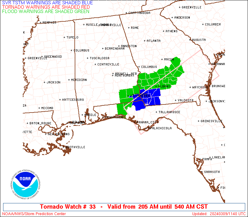
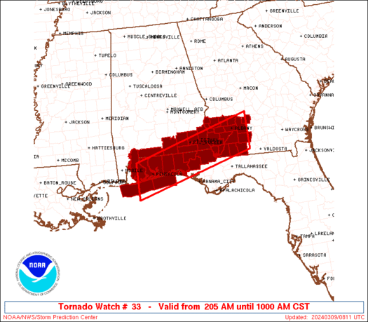
Tornado Watch Number 33
NWS Storm Prediction Center Norman OK
205 AM CST Sat Mar 9 2024
The NWS Storm Prediction Center has issued a
* Tornado Watch for portions of
Southern Alabama
Florida Panhandle
Southwestern Georgia
Coastal Waters
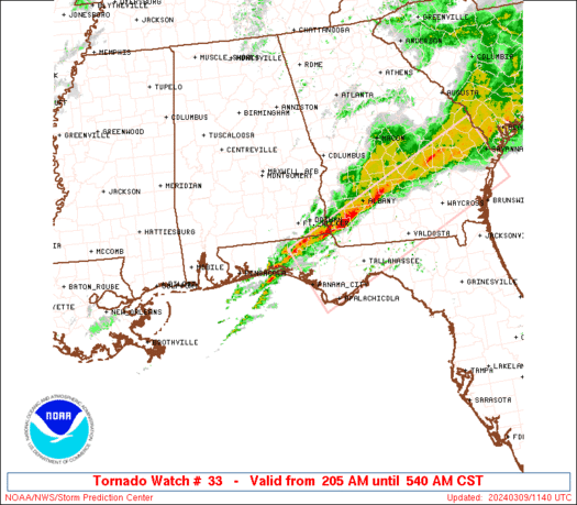
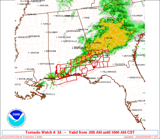
* Effective this Saturday morning from 205 AM until 1000 AM CST.
* Primary threats include...
A couple intense tornadoes possible
Scattered damaging wind gusts to 70 mph possible
Isolated large hail events to 1.5 inches in diameter possible
SUMMARY...A band of thunderstorms will continue shifting slowly
eastward over the watch area through the remainder of the morning,
as embedded strong-severe thunderstorms move rapidly along its axis.
The environment has become and will remain favorable for
occasional, embedded, potentially tornadic circulations.
The tornado watch area is approximately along and 40 statute miles
north and south of a line from 35 miles west southwest of Pensacola
FL to 25 miles north northeast of Moultrie GA. For a complete
depiction of the watch see the associated watch outline update
(WOUS64 KWNS WOU3).
PRECAUTIONARY/PREPAREDNESS ACTIONS...
REMEMBER...A Tornado Watch means conditions are favorable for
tornadoes and severe thunderstorms in and close to the watch
area. Persons in these areas should be on the lookout for
threatening weather conditions and listen for later statements
and possible warnings.
&&
AVIATION...Tornadoes and a few severe thunderstorms with hail
surface and aloft to 1.5 inches. Extreme turbulence and surface wind
gusts to 60 knots. A few cumulonimbi with maximum tops to 450. Mean
storm motion vector 24040.
...Edwards
   SEL3

   URGENT - IMMEDIATE BROADCAST REQUESTED
   Tornado Watch Number 33
   NWS Storm Prediction Center Norman OK
   205 AM CST Sat Mar 9 2024

   The NWS Storm Prediction Center has issued a

   * Tornado Watch for portions of
     Southern Alabama
     Florida Panhandle
     Southwestern Georgia
     Coastal Waters

   * Effective this Saturday morning from 205 AM until 1000 AM CST.

   * Primary threats include...
     A couple intense tornadoes possible
     Scattered damaging wind gusts to 70 mph possible
     Isolated large hail events to 1.5 inches in diameter possible

   SUMMARY...A band of thunderstorms will continue shifting slowly
   eastward over the watch area through the remainder of the morning,
   as embedded strong-severe thunderstorms move rapidly along its axis.
    The environment has become and will remain favorable for
   occasional, embedded, potentially tornadic circulations.

   The tornado watch area is approximately along and 40 statute miles
   north and south of a line from 35 miles west southwest of Pensacola
   FL to 25 miles north northeast of Moultrie GA. For a complete
   depiction of the watch see the associated watch outline update
   (WOUS64 KWNS WOU3).

   PRECAUTIONARY/PREPAREDNESS ACTIONS...

   REMEMBER...A Tornado Watch means conditions are favorable for
   tornadoes and severe thunderstorms in and close to the watch
   area. Persons in these areas should be on the lookout for
   threatening weather conditions and listen for later statements
   and possible warnings.

   &&

   AVIATION...Tornadoes and a few severe thunderstorms with hail
   surface and aloft to 1.5 inches. Extreme turbulence and surface wind
   gusts to 60 knots. A few cumulonimbi with maximum tops to 450. Mean
   storm motion vector 24040.

   ...Edwards
 Note:
The Aviation Watch (SAW) product is an approximation to the watch area.
The actual watch is depicted by the shaded areas.
Note:
The Aviation Watch (SAW) product is an approximation to the watch area.
The actual watch is depicted by the shaded areas.
   SAW3
   WW 33 TORNADO AL FL GA CW 090805Z - 091600Z
   AXIS..40 STATUTE MILES NORTH AND SOUTH OF LINE..
   35WSW PNS/PENSACOLA FL/ - 25NNE MGR/MOULTRIE GA/
   ..AVIATION COORDS.. 35NM N/S /43SE SJI - 36ESE PZD/
   HAIL SURFACE AND ALOFT..1.5 INCHES. WIND GUSTS..60 KNOTS.
   MAX TOPS TO 450. MEAN STORM MOTION VECTOR 24040.

   LAT...LON 30858772 31998364 30848364 29708772

   THIS IS AN APPROXIMATION TO THE WATCH AREA.  FOR A
   COMPLETE DEPICTION OF THE WATCH SEE WOUS64 KWNS
   FOR WOU3.
Watch 33 Status Report Messages:
STATUS REPORT #2 ON WW 33
VALID 091140Z - 091240Z
SEVERE WEATHER THREAT CONTINUES RIGHT OF A LINE FROM 25 SE PNS TO
15 SSE CEW TO 35 SW DHN TO 25 ESE DHN TO 30 WSW ABY TO 15 NE ABY
TO 40 S MCN.
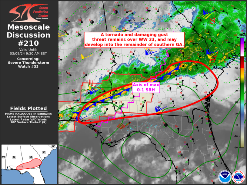
FOR ADDITIONAL INFORMATION SEE MESOSCALE DISCUSSION 210
..JEWELL..03/09/24
ATTN...WFO...MOB...TAE...
&&
STATUS REPORT FOR WT 33
SEVERE WEATHER THREAT CONTINUES FOR THE FOLLOWING AREAS
ALC069-091240-
AL
. ALABAMA COUNTIES INCLUDED ARE
HOUSTON
$$
FLC059-063-131-133-091240-
FL
. FLORIDA COUNTIES INCLUDED ARE
HOLMES JACKSON WALTON
WASHINGTON
$$
GAC007-037-071-087-095-099-131-201-205-253-275-287-321-091240-
GA
. GEORGIA COUNTIES INCLUDED ARE
BAKER CALHOUN COLQUITT
DECATUR DOUGHERTY EARLY
GRADY MILLER MITCHELL
SEMINOLE THOMAS TURNER
WORTH
$$
THE WATCH STATUS MESSAGE IS FOR GUIDANCE PURPOSES ONLY. PLEASE
REFER TO WATCH COUNTY NOTIFICATION STATEMENTS FOR OFFICIAL
INFORMATION ON COUNTIES...INDEPENDENT CITIES AND MARINE ZONES
CLEARED FROM SEVERE THUNDERSTORM AND TORNADO WATCHES.
$$
STATUS REPORT #1 ON WW 33
VALID 091020Z - 091140Z
SEVERE WEATHER THREAT CONTINUES RIGHT OF A LINE FROM 30 SE MOB TO
10 NNW PNS TO 15 NW CEW TO 30 W DHN TO 10 NNE DHN TO 30 NE DHN TO
40 WNW ABY TO 40 SSE CSG.
..JEWELL..03/09/24
ATTN...WFO...MOB...TAE...
&&
STATUS REPORT FOR WT 33
SEVERE WEATHER THREAT CONTINUES FOR THE FOLLOWING AREAS
ALC045-061-067-069-091140-
AL
. ALABAMA COUNTIES INCLUDED ARE
DALE GENEVA HENRY
HOUSTON
$$
FLC059-063-091-113-131-133-091140-
FL
. FLORIDA COUNTIES INCLUDED ARE
HOLMES JACKSON OKALOOSA
SANTA ROSA WALTON WASHINGTON
$$
GAC007-037-061-071-087-095-099-131-177-201-205-243-253-273-275-
287-321-091140-
GA
. GEORGIA COUNTIES INCLUDED ARE
BAKER CALHOUN CLAY
COLQUITT DECATUR DOUGHERTY
EARLY GRADY LEE
MILLER MITCHELL RANDOLPH
SEMINOLE TERRELL THOMAS
TURNER WORTH
$$
GMZ633-634-635-636-650-655-091140-
CW
. ADJACENT COASTAL WATERS INCLUDED ARE
PERDIDO BAY AREA
PENSACOLA BAY AREA INCLUDING SANTA ROSA SOUND
WESTERN CHOCTAWHATCHEE BAY
EASTERN CHOCTAWHATCHEE BAY
COASTAL WATERS FROM PENSACOLA FL TO PASCAGOULA MS OUT 20 NM
COASTAL WATERS FROM OKALOOSA-WALTON COUNTY LINE TO PENSACOLA FL
OUT 20 NM
$$
THE WATCH STATUS MESSAGE IS FOR GUIDANCE PURPOSES ONLY. PLEASE
REFER TO WATCH COUNTY NOTIFICATION STATEMENTS FOR OFFICIAL
INFORMATION ON COUNTIES...INDEPENDENT CITIES AND MARINE ZONES
CLEARED FROM SEVERE THUNDERSTORM AND TORNADO WATCHES.
$$
Note:
Click for Complete Product Text.
Tornadoes
Probability of 2 or more tornadoes
|
Mod (40%)
|
Probability of 1 or more strong (EF2-EF5) tornadoes
|
Mod (30%)
|
Wind
Probability of 10 or more severe wind events
|
Mod (40%)
|
Probability of 1 or more wind events > 65 knots
|
Low (20%)
|
Hail
Probability of 10 or more severe hail events
|
Low (20%)
|
Probability of 1 or more hailstones > 2 inches
|
Low (10%)
|
Combined Severe Hail/Wind
Probability of 6 or more combined severe hail/wind events
|
Mod (60%)
|
For each watch, probabilities for particular events inside the watch
(listed above in each table) are determined by the issuing forecaster.
The "Low" category contains probability values ranging from less than 2%
to 20% (EF2-EF5 tornadoes), less than 5% to 20% (all other probabilities),
"Moderate" from 30% to 60%, and "High" from 70% to greater than 95%.
High values are bolded and lighter in color to provide awareness of
an increased threat for a particular event.


 @NWSSPC