 Note:
The expiration time in the watch graphic is amended if the watch is
replaced, cancelled or extended.
Note:
Note:
The expiration time in the watch graphic is amended if the watch is
replaced, cancelled or extended.
Note: Click for
Watch Status Reports.
SEL9
URGENT - IMMEDIATE BROADCAST REQUESTED
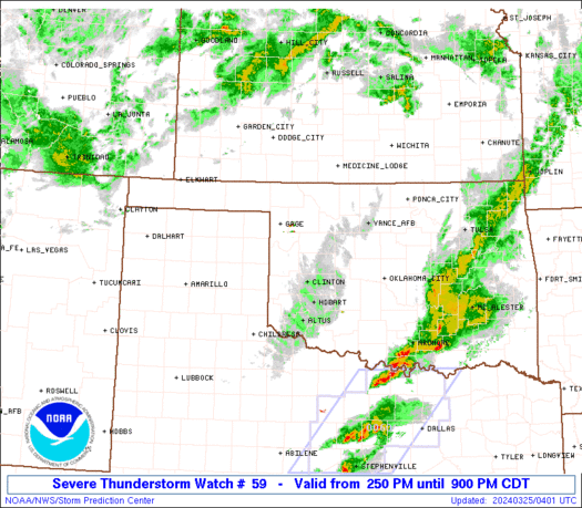
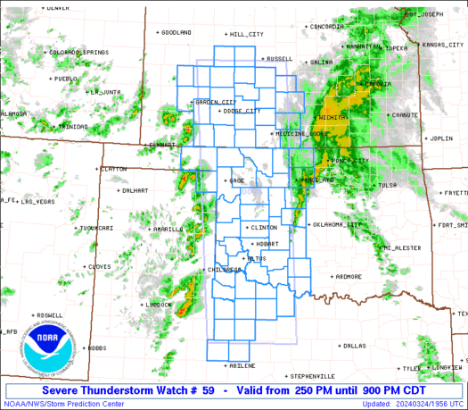
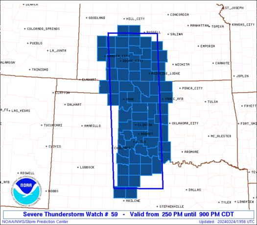
Severe Thunderstorm Watch Number 59
NWS Storm Prediction Center Norman OK
250 PM CDT Sun Mar 24 2024
The NWS Storm Prediction Center has issued a
* Severe Thunderstorm Watch for portions of
West Central Kansas
Western Oklahoma
Western North Texas
* Effective this Sunday afternoon and evening from 250 PM until
900 PM CDT.
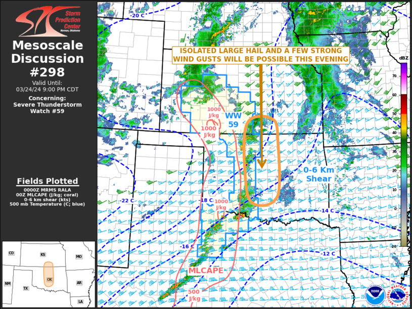
* Primary threats include...
Scattered large hail likely with isolated very large hail events
to 2 inches in diameter possible
Scattered damaging wind gusts to 70 mph possible
A tornado or two possible
SUMMARY...Thunderstorms are developing along a dryline over the
Texas Panhandle. These storms will spread eastward through the
afternoon, posing a risk of large hail and damaging winds. A
tornado or two is also possible.
The severe thunderstorm watch area is approximately along and 65
statute miles east and west of a line from 80 miles north northeast
of Dodge City KS to 80 miles south southwest of Wichita Falls TX.
For a complete depiction of the watch see the associated watch
outline update (WOUS64 KWNS WOU9).
PRECAUTIONARY/PREPAREDNESS ACTIONS...
REMEMBER...A Severe Thunderstorm Watch means conditions are
favorable for severe thunderstorms in and close to the watch area.
Persons in these areas should be on the lookout for threatening
weather conditions and listen for later statements and possible
warnings. Severe thunderstorms can and occasionally do produce
tornadoes.
&&
AVIATION...A few severe thunderstorms with hail surface and aloft to
2 inches. Extreme turbulence and surface wind gusts to 60 knots. A
few cumulonimbi with maximum tops to 500. Mean storm motion vector
25035.
...Hart
   SEL9

   URGENT - IMMEDIATE BROADCAST REQUESTED
   Severe Thunderstorm Watch Number 59
   NWS Storm Prediction Center Norman OK
   250 PM CDT Sun Mar 24 2024

   The NWS Storm Prediction Center has issued a

   * Severe Thunderstorm Watch for portions of
     West Central Kansas
     Western Oklahoma
     Western North Texas

   * Effective this Sunday afternoon and evening from 250 PM until
     900 PM CDT.

   * Primary threats include...
     Scattered large hail likely with isolated very large hail events
       to 2 inches in diameter possible
     Scattered damaging wind gusts to 70 mph possible
     A tornado or two possible

   SUMMARY...Thunderstorms are developing along a dryline over the
   Texas Panhandle.  These storms will spread eastward through the
   afternoon, posing a risk of large hail and damaging winds.  A
   tornado or two is also possible.

   The severe thunderstorm watch area is approximately along and 65
   statute miles east and west of a line from 80 miles north northeast
   of Dodge City KS to 80 miles south southwest of Wichita Falls TX.
   For a complete depiction of the watch see the associated watch
   outline update (WOUS64 KWNS WOU9).

   PRECAUTIONARY/PREPAREDNESS ACTIONS...

   REMEMBER...A Severe Thunderstorm Watch means conditions are
   favorable for severe thunderstorms in and close to the watch area.
   Persons in these areas should be on the lookout for threatening
   weather conditions and listen for later statements and possible
   warnings. Severe thunderstorms can and occasionally do produce
   tornadoes.

   &&

   AVIATION...A few severe thunderstorms with hail surface and aloft to
   2 inches. Extreme turbulence and surface wind gusts to 60 knots. A
   few cumulonimbi with maximum tops to 500. Mean storm motion vector
   25035.

   ...Hart
 Note:
The Aviation Watch (SAW) product is an approximation to the watch area.
The actual watch is depicted by the shaded areas.
Note:
The Aviation Watch (SAW) product is an approximation to the watch area.
The actual watch is depicted by the shaded areas.
   SAW9
   WW 59 SEVERE TSTM KS OK TX 241950Z - 250200Z
   AXIS..65 STATUTE MILES EAST AND WEST OF LINE..
   80NNE DDC/DODGE CITY KS/ - 80SSW SPS/WICHITA FALLS TX/
   ..AVIATION COORDS.. 55NM E/W /46ESE HLC - 49ENE ABI/
   HAIL SURFACE AND ALOFT..2 INCHES. WIND GUSTS..60 KNOTS.
   MAX TOPS TO 500. MEAN STORM MOTION VECTOR 25035.

   LAT...LON 38839819 32899791 32890015 38830061

   THIS IS AN APPROXIMATION TO THE WATCH AREA.  FOR A
   COMPLETE DEPICTION OF THE WATCH SEE WOUS64 KWNS
   FOR WOU9.
Watch 59 Status Report Messages:
STATUS REPORT #4 ON WW 59

VALID 250145Z - 250240Z

SEVERE WEATHER THREAT CONTINUES RIGHT OF A LINE FROM 5 NE ABI TO
10 WSW SPS TO 15 NNE CHK.

..BROYLES..03/25/24

ATTN...WFO...DDC...ICT...OUN...AMA...SJT...

&&

STATUS REPORT FOR WS 59

SEVERE WEATHER THREAT CONTINUES FOR THE FOLLOWING AREAS

OKC019-033-067-085-137-250240-

OK
.    OKLAHOMA COUNTIES INCLUDED ARE

CARTER		     COTTON		 JEFFERSON
LOVE		     STEPHENS
$$


TXC009-077-417-250240-

TX
.    TEXAS COUNTIES INCLUDED ARE

ARCHER		     CLAY		 SHACKELFORD
$$


THE WATCH STATUS MESSAGE IS FOR GUIDANCE PURPOSES ONLY.  PLEASE
REFER TO WATCH COUNTY NOTIFICATION STATEMENTS FOR OFFICIAL
INFORMATION ON COUNTIES...INDEPENDENT CITIES AND MARINE ZONES
CLEARED FROM SEVERE THUNDERSTORM AND TORNADO WATCHES.
$$

STATUS REPORT #3 ON WW 59

VALID 250035Z - 250140Z

SEVERE WEATHER THREAT CONTINUES RIGHT OF A LINE FROM 40 W ABI TO
30 SW FSI TO 10 WNW CHK TO 20 W END TO 30 NNW P28 TO 35 S HLC.

..BROYLES..03/25/24

ATTN...WFO...DDC...ICT...OUN...AMA...SJT...

&&

STATUS REPORT FOR WS 59

SEVERE WEATHER THREAT CONTINUES FOR THE FOLLOWING AREAS

KSC009-051-077-095-145-151-155-159-165-185-195-250140-

KS
.    KANSAS COUNTIES INCLUDED ARE

BARTON		     ELLIS		 HARPER
KINGMAN 	     PAWNEE		 PRATT
RENO		     RICE		 RUSH
STAFFORD	     TREGO
$$


OKC003-017-019-031-033-047-051-053-067-073-085-137-250140-

OK
.    OKLAHOMA COUNTIES INCLUDED ARE

ALFALFA 	     CANADIAN		 CARTER
COMANCHE	     COTTON		 GARFIELD
GRADY		     GRANT		 JEFFERSON
KINGFISHER	     LOVE		 STEPHENS
$$


TXC009-023-077-207-253-417-447-485-250140-

TX
.    TEXAS COUNTIES INCLUDED ARE

ARCHER		     BAYLOR		 CLAY
HASKELL 	     JONES		 SHACKELFORD
THROCKMORTON	     WICHITA
$$


THE WATCH STATUS MESSAGE IS FOR GUIDANCE PURPOSES ONLY.  PLEASE
REFER TO WATCH COUNTY NOTIFICATION STATEMENTS FOR OFFICIAL
INFORMATION ON COUNTIES...INDEPENDENT CITIES AND MARINE ZONES
CLEARED FROM SEVERE THUNDERSTORM AND TORNADO WATCHES.
$$

STATUS REPORT #2 ON WW 59

VALID 242340Z - 250040Z

SEVERE WEATHER THREAT CONTINUES RIGHT OF A LINE FROM 25 SSW CDS
TO 30 SE CSM TO 15 SW AVK TO 40 WSW P28 TO 20 SSW GCK.

..WEINMAN..03/24/24

ATTN...WFO...DDC...ICT...OUN...AMA...SJT...

&&

STATUS REPORT FOR WS 59

SEVERE WEATHER THREAT CONTINUES FOR THE FOLLOWING AREAS

KSC007-009-025-033-047-051-055-057-069-077-083-095-097-101-119-
135-145-151-155-159-165-171-185-195-250040-

KS
.    KANSAS COUNTIES INCLUDED ARE

BARBER		     BARTON		 CLARK
COMANCHE	     EDWARDS		 ELLIS
FINNEY		     FORD		 GRAY
HARPER		     HODGEMAN		 KINGMAN
KIOWA		     LANE		 MEADE
NESS		     PAWNEE		 PRATT
RENO		     RICE		 RUSH
SCOTT		     STAFFORD		 TREGO
$$


OKC003-011-015-017-031-033-039-043-047-051-053-065-067-073-075-
093-137-141-149-151-153-250040-

OK
.    OKLAHOMA COUNTIES INCLUDED ARE

ALFALFA 	     BLAINE		 CADDO
CANADIAN	     COMANCHE		 COTTON
CUSTER		     DEWEY		 GARFIELD
GRADY		     GRANT		 JACKSON
JEFFERSON	     KINGFISHER 	 KIOWA
MAJOR		     STEPHENS		 TILLMAN
WASHITA 	     WOODS		 WOODWARD
$$


TXC009-023-077-155-197-207-253-275-417-447-485-487-250040-

TX
.    TEXAS COUNTIES INCLUDED ARE

ARCHER		     BAYLOR		 CLAY
FOARD		     HARDEMAN		 HASKELL
JONES		     KNOX		 SHACKELFORD
THROCKMORTON	     WICHITA		 WILBARGER
$$


THE WATCH STATUS MESSAGE IS FOR GUIDANCE PURPOSES ONLY.  PLEASE
REFER TO WATCH COUNTY NOTIFICATION STATEMENTS FOR OFFICIAL
INFORMATION ON COUNTIES...INDEPENDENT CITIES AND MARINE ZONES
CLEARED FROM SEVERE THUNDERSTORM AND TORNADO WATCHES.
$$

STATUS REPORT #1 ON WW 59

VALID 242145Z - 242240Z

THE SEVERE WEATHER THREAT CONTINUES ACROSS THE ENTIRE WATCH AREA.

..BROYLES..03/24/24

ATTN...WFO...DDC...ICT...OUN...AMA...SJT...

&&

STATUS REPORT FOR WS 59

SEVERE WEATHER THREAT CONTINUES FOR THE FOLLOWING AREAS

KSC007-009-025-033-047-051-055-057-069-077-083-095-097-101-119-
135-145-151-155-159-165-171-185-195-242240-

KS
.    KANSAS COUNTIES INCLUDED ARE

BARBER		     BARTON		 CLARK
COMANCHE	     EDWARDS		 ELLIS
FINNEY		     FORD		 GRAY
HARPER		     HODGEMAN		 KINGMAN
KIOWA		     LANE		 MEADE
NESS		     PAWNEE		 PRATT
RENO		     RICE		 RUSH
SCOTT		     STAFFORD		 TREGO
$$


OKC003-007-009-011-015-017-031-033-039-043-045-047-051-053-055-
057-059-065-067-073-075-093-129-137-141-149-151-153-242240-

OK
.    OKLAHOMA COUNTIES INCLUDED ARE

ALFALFA 	     BEAVER		 BECKHAM
BLAINE		     CADDO		 CANADIAN
COMANCHE	     COTTON		 CUSTER
DEWEY		     ELLIS		 GARFIELD
GRADY		     GRANT		 GREER
HARMON		     HARPER		 JACKSON
JEFFERSON	     KINGFISHER 	 KIOWA
MAJOR		     ROGER MILLS	 STEPHENS
TILLMAN 	     WASHITA		 WOODS
WOODWARD
$$


TXC009-023-077-155-197-207-253-275-295-417-447-485-487-242240-

TX
.    TEXAS COUNTIES INCLUDED ARE

ARCHER		     BAYLOR		 CLAY
FOARD		     HARDEMAN		 HASKELL
JONES		     KNOX		 LIPSCOMB
SHACKELFORD	     THROCKMORTON	 WICHITA
WILBARGER
$$


THE WATCH STATUS MESSAGE IS FOR GUIDANCE PURPOSES ONLY.  PLEASE
REFER TO WATCH COUNTY NOTIFICATION STATEMENTS FOR OFFICIAL
INFORMATION ON COUNTIES...INDEPENDENT CITIES AND MARINE ZONES
CLEARED FROM SEVERE THUNDERSTORM AND TORNADO WATCHES.
$$
Note:
Click for Complete Product Text.
Tornadoes
Probability of 2 or more tornadoes
|
Low (20%)
|
Probability of 1 or more strong (EF2-EF5) tornadoes
|
Low (5%)
|
Wind
Probability of 10 or more severe wind events
|
Mod (50%)
|
Probability of 1 or more wind events > 65 knots
|
Low (20%)
|
Hail
Probability of 10 or more severe hail events
|
High (70%)
|
Probability of 1 or more hailstones > 2 inches
|
Mod (30%)
|
Combined Severe Hail/Wind
Probability of 6 or more combined severe hail/wind events
|
High (>95%)
|
For each watch, probabilities for particular events inside the watch
(listed above in each table) are determined by the issuing forecaster.
The "Low" category contains probability values ranging from less than 2%
to 20% (EF2-EF5 tornadoes), less than 5% to 20% (all other probabilities),
"Moderate" from 30% to 60%, and "High" from 70% to greater than 95%.
High values are bolded and lighter in color to provide awareness of
an increased threat for a particular event.


 @NWSSPC