 Note:
The expiration time in the watch graphic is amended if the watch is
replaced, cancelled or extended.
Note:
Note:
The expiration time in the watch graphic is amended if the watch is
replaced, cancelled or extended.
Note: Click for
Watch Status Reports.
SEL3
URGENT - IMMEDIATE BROADCAST REQUESTED
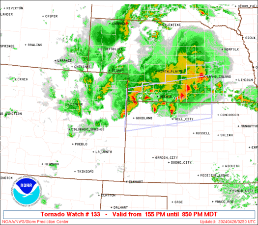
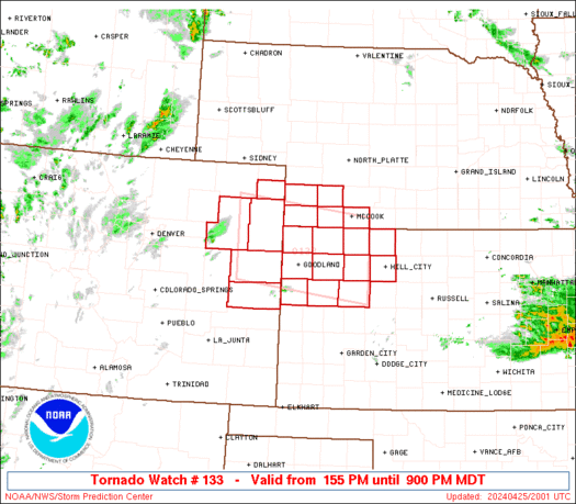
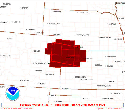
Tornado Watch Number 133
NWS Storm Prediction Center Norman OK
155 PM MDT Thu Apr 25 2024
The NWS Storm Prediction Center has issued a
* Tornado Watch for portions of
Northeast Colorado
Northwest Kansas
Southwest Nebraska
* Effective this Thursday afternoon and evening from 155 PM until
900 PM MDT.
* Primary threats include...
A few tornadoes likely with a couple intense tornadoes possible
Scattered large hail and isolated very large hail events to 3
inches in diameter likely
Scattered damaging winds likely with isolated significant gusts
to 75 mph possible
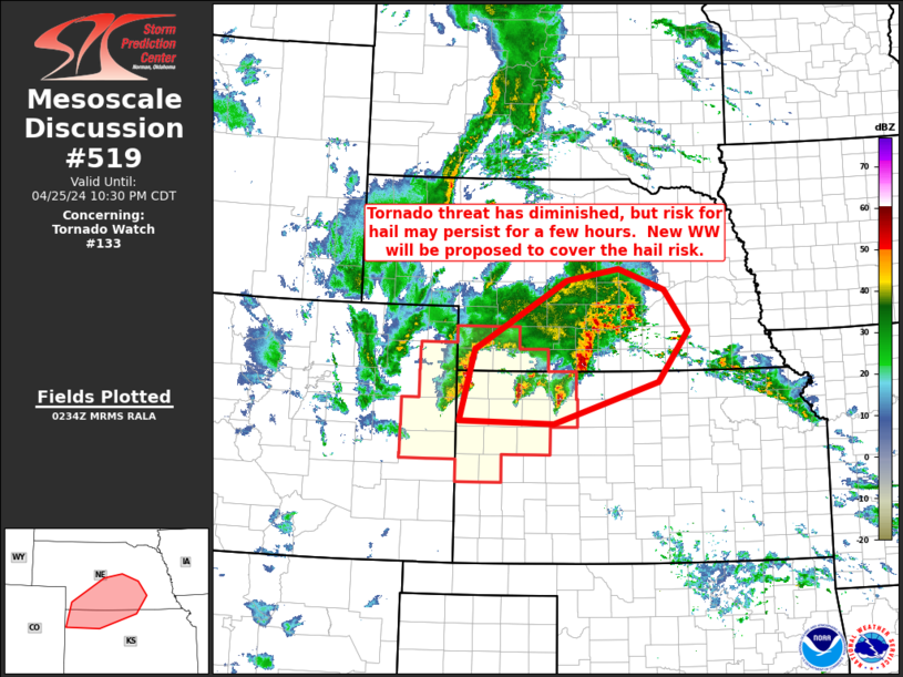
SUMMARY...Thunderstorms are expected to rapidly intensify this
afternoon, with a few supercell storms likely. Very large hail, a
few tornadoes, and damaging winds will all be possible with this
activity through the evening.
The tornado watch area is approximately along and 50 statute miles
north and south of a line from 55 miles northwest of Burlington CO
to 55 miles south southeast of Mccook NE. For a complete depiction
of the watch see the associated watch outline update (WOUS64 KWNS
WOU3).
PRECAUTIONARY/PREPAREDNESS ACTIONS...
REMEMBER...A Tornado Watch means conditions are favorable for
tornadoes and severe thunderstorms in and close to the watch
area. Persons in these areas should be on the lookout for
threatening weather conditions and listen for later statements
and possible warnings.
&&
AVIATION...Tornadoes and a few severe thunderstorms with hail
surface and aloft to 3 inches. Extreme turbulence and surface wind
gusts to 65 knots. A few cumulonimbi with maximum tops to 500. Mean
storm motion vector 26035.
...Hart
   SEL3

   URGENT - IMMEDIATE BROADCAST REQUESTED
   Tornado Watch Number 133
   NWS Storm Prediction Center Norman OK
   155 PM MDT Thu Apr 25 2024

   The NWS Storm Prediction Center has issued a

   * Tornado Watch for portions of
     Northeast Colorado
     Northwest Kansas
     Southwest Nebraska

   * Effective this Thursday afternoon and evening from 155 PM until
     900 PM MDT.

   * Primary threats include...
     A few tornadoes likely with a couple intense tornadoes possible
     Scattered large hail and isolated very large hail events to 3
       inches in diameter likely
     Scattered damaging winds likely with isolated significant gusts
       to 75 mph possible

   SUMMARY...Thunderstorms are expected to rapidly intensify this
   afternoon, with a few supercell storms likely.  Very large hail, a
   few tornadoes, and damaging winds will all be possible with this
   activity through the evening.

   The tornado watch area is approximately along and 50 statute miles
   north and south of a line from 55 miles northwest of Burlington CO
   to 55 miles south southeast of Mccook NE. For a complete depiction
   of the watch see the associated watch outline update (WOUS64 KWNS
   WOU3).

   PRECAUTIONARY/PREPAREDNESS ACTIONS...

   REMEMBER...A Tornado Watch means conditions are favorable for
   tornadoes and severe thunderstorms in and close to the watch
   area. Persons in these areas should be on the lookout for
   threatening weather conditions and listen for later statements
   and possible warnings.

   &&

   AVIATION...Tornadoes and a few severe thunderstorms with hail
   surface and aloft to 3 inches. Extreme turbulence and surface wind
   gusts to 65 knots. A few cumulonimbi with maximum tops to 500. Mean
   storm motion vector 26035.

   ...Hart
 Note:
The Aviation Watch (SAW) product is an approximation to the watch area.
The actual watch is depicted by the shaded areas.
Note:
The Aviation Watch (SAW) product is an approximation to the watch area.
The actual watch is depicted by the shaded areas.
   SAW3
   WW 133 TORNADO CO KS NE 251955Z - 260300Z
   AXIS..50 STATUTE MILES NORTH AND SOUTH OF LINE..
   55NW ITR/BURLINGTON CO/ - 55SSE MCK/MCCOOK NE/
   ..AVIATION COORDS.. 45NM N/S /23SSE AKO - 12N HLC/
   HAIL SURFACE AND ALOFT..3 INCHES. WIND GUSTS..65 KNOTS.
   MAX TOPS TO 500. MEAN STORM MOTION VECTOR 26035.

   LAT...LON 40520301 40180019 38740019 39080301

   THIS IS AN APPROXIMATION TO THE WATCH AREA.  FOR A
   COMPLETE DEPICTION OF THE WATCH SEE WOUS64 KWNS
   FOR WOU3.
Watch 133 Status Report Messages:
STATUS REPORT #2 ON WW 133

VALID 260215Z - 260340Z

THE SEVERE WEATHER THREAT CONTINUES ACROSS THE ENTIRE WATCH AREA.

..GOSS..04/26/24

ATTN...WFO...GLD...BOU...LBF...

&&

STATUS REPORT FOR WT 133

SEVERE WEATHER THREAT CONTINUES FOR THE FOLLOWING AREAS

COC017-063-075-095-115-121-125-260340-

CO
.    COLORADO COUNTIES INCLUDED ARE

CHEYENNE	     KIT CARSON 	 LOGAN
PHILLIPS	     SEDGWICK		 WASHINGTON
YUMA
$$


KSC023-039-063-065-071-109-137-153-179-181-193-199-203-260340-

KS
.    KANSAS COUNTIES INCLUDED ARE

CHEYENNE	     DECATUR		 GOVE
GRAHAM		     GREELEY		 LOGAN
NORTON		     RAWLINS		 SHERIDAN
SHERMAN 	     THOMAS		 WALLACE
WICHITA
$$


NEC029-057-085-087-145-260340-

NE
.    NEBRASKA COUNTIES INCLUDED ARE

CHASE		     DUNDY		 HAYES
HITCHCOCK	     RED WILLOW
$$


THE WATCH STATUS MESSAGE IS FOR GUIDANCE PURPOSES ONLY.  PLEASE
REFER TO WATCH COUNTY NOTIFICATION STATEMENTS FOR OFFICIAL
INFORMATION ON COUNTIES...INDEPENDENT CITIES AND MARINE ZONES
CLEARED FROM SEVERE THUNDERSTORM AND TORNADO WATCHES.
$$

STATUS REPORT #1 ON WW 133

VALID 260040Z - 260140Z

THE SEVERE WEATHER THREAT CONTINUES ACROSS THE ENTIRE WATCH AREA.

..GOSS..04/26/24

ATTN...WFO...GLD...BOU...LBF...

&&

STATUS REPORT FOR WT 133

SEVERE WEATHER THREAT CONTINUES FOR THE FOLLOWING AREAS

COC017-063-075-095-115-121-125-260140-

CO
.    COLORADO COUNTIES INCLUDED ARE

CHEYENNE	     KIT CARSON 	 LOGAN
PHILLIPS	     SEDGWICK		 WASHINGTON
YUMA
$$


KSC023-039-063-065-071-109-137-153-179-181-193-199-203-260140-

KS
.    KANSAS COUNTIES INCLUDED ARE

CHEYENNE	     DECATUR		 GOVE
GRAHAM		     GREELEY		 LOGAN
NORTON		     RAWLINS		 SHERIDAN
SHERMAN 	     THOMAS		 WALLACE
WICHITA
$$


NEC029-057-085-087-145-260140-

NE
.    NEBRASKA COUNTIES INCLUDED ARE

CHASE		     DUNDY		 HAYES
HITCHCOCK	     RED WILLOW
$$


THE WATCH STATUS MESSAGE IS FOR GUIDANCE PURPOSES ONLY.  PLEASE
REFER TO WATCH COUNTY NOTIFICATION STATEMENTS FOR OFFICIAL
INFORMATION ON COUNTIES...INDEPENDENT CITIES AND MARINE ZONES
CLEARED FROM SEVERE THUNDERSTORM AND TORNADO WATCHES.
$$
Note:
Click for Complete Product Text.
Tornadoes
Probability of 2 or more tornadoes
|
Mod (60%)
|
Probability of 1 or more strong (EF2-EF5) tornadoes
|
Mod (40%)
|
Wind
Probability of 10 or more severe wind events
|
High (70%)
|
Probability of 1 or more wind events > 65 knots
|
Mod (30%)
|
Hail
Probability of 10 or more severe hail events
|
High (70%)
|
Probability of 1 or more hailstones > 2 inches
|
Mod (60%)
|
Combined Severe Hail/Wind
Probability of 6 or more combined severe hail/wind events
|
High (>95%)
|
For each watch, probabilities for particular events inside the watch
(listed above in each table) are determined by the issuing forecaster.
The "Low" category contains probability values ranging from less than 2%
to 20% (EF2-EF5 tornadoes), less than 5% to 20% (all other probabilities),
"Moderate" from 30% to 60%, and "High" from 70% to greater than 95%.
High values are bolded and lighter in color to provide awareness of
an increased threat for a particular event.


 @NWSSPC