Note:
The expiration time in the watch graphic is amended if the watch is
replaced, cancelled or extended.
Note:
Note:
The expiration time in the watch graphic is amended if the watch is
replaced, cancelled or extended.
Note: Click for
Watch Status Reports.
SEL5
URGENT - IMMEDIATE BROADCAST REQUESTED
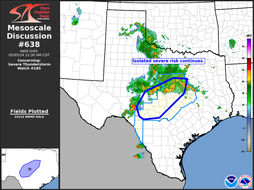
Severe Thunderstorm Watch Number 185
NWS Storm Prediction Center Norman OK
700 PM CDT Sat May 4 2024
The NWS Storm Prediction Center has issued a
* Severe Thunderstorm Watch for portions of
Central and South-Central Texas
* Effective this Saturday night and Sunday morning from 700 PM
until 200 AM CDT.
* Primary threats include...
Scattered large hail and isolated very large hail events to 2.5
inches in diameter possible
Scattered damaging wind gusts to 70 mph possible
A tornado or two possible
SUMMARY...Severe storms including supercells will gradually spread
eastward into a broad part of central Texas, and possibly across the
Rio Grande, while upstream storms across southwest Texas are also
expected to organize and move into the region.
The severe thunderstorm watch area is approximately along and 60
statute miles east and west of a line from 45 miles east northeast
of Stephenville TX to 40 miles west southwest of Hondo TX. For a
complete depiction of the watch see the associated watch outline
update (WOUS64 KWNS WOU5).
PRECAUTIONARY/PREPAREDNESS ACTIONS...
REMEMBER...A Severe Thunderstorm Watch means conditions are
favorable for severe thunderstorms in and close to the watch area.
Persons in these areas should be on the lookout for threatening
weather conditions and listen for later statements and possible
warnings. Severe thunderstorms can and occasionally do produce
tornadoes.
&&
OTHER WATCH INFORMATION...CONTINUE...WW 183...WW 184...
AVIATION...A few severe thunderstorms with hail surface and aloft to
2.5 inches. Extreme turbulence and surface wind gusts to 60 knots. A
few cumulonimbi with maximum tops to 550. Mean storm motion vector
29025.
...Guyer

   SEL5

   URGENT - IMMEDIATE BROADCAST REQUESTED
   Severe Thunderstorm Watch Number 185
   NWS Storm Prediction Center Norman OK
   700 PM CDT Sat May 4 2024

   The NWS Storm Prediction Center has issued a

   * Severe Thunderstorm Watch for portions of
     Central and South-Central Texas

   * Effective this Saturday night and Sunday morning from 700 PM
     until 200 AM CDT.

   * Primary threats include...
     Scattered large hail and isolated very large hail events to 2.5
       inches in diameter possible
     Scattered damaging wind gusts to 70 mph possible
     A tornado or two possible

   SUMMARY...Severe storms including supercells will gradually spread
   eastward into a broad part of central Texas, and possibly across the
   Rio Grande, while upstream storms across southwest Texas are also
   expected to organize and move into the region.

   The severe thunderstorm watch area is approximately along and 60
   statute miles east and west of a line from 45 miles east northeast
   of Stephenville TX to 40 miles west southwest of Hondo TX. For a
   complete depiction of the watch see the associated watch outline
   update (WOUS64 KWNS WOU5).

   PRECAUTIONARY/PREPAREDNESS ACTIONS...

   REMEMBER...A Severe Thunderstorm Watch means conditions are
   favorable for severe thunderstorms in and close to the watch area.
   Persons in these areas should be on the lookout for threatening
   weather conditions and listen for later statements and possible
   warnings. Severe thunderstorms can and occasionally do produce
   tornadoes.

   &&

   OTHER WATCH INFORMATION...CONTINUE...WW 183...WW 184...

   AVIATION...A few severe thunderstorms with hail surface and aloft to
   2.5 inches. Extreme turbulence and surface wind gusts to 60 knots. A
   few cumulonimbi with maximum tops to 550. Mean storm motion vector
   29025.

   ...Guyer
 Note:
The Aviation Watch (SAW) product is an approximation to the watch area.
The actual watch is depicted by the shaded areas.
Note:
The Aviation Watch (SAW) product is an approximation to the watch area.
The actual watch is depicted by the shaded areas.
   SAW5
   WW 185 SEVERE TSTM TX 050000Z - 050700Z
   AXIS..60 STATUTE MILES EAST AND WEST OF LINE..
   45ENE SEP/STEPHENVILLE TX/ - 40WSW HDO/HONDO TX/
   ..AVIATION COORDS.. 50NM E/W /32SW TTT - 53ESE DLF/
   HAIL SURFACE AND ALOFT..2.5 INCHES. WIND GUSTS..60 KNOTS.
   MAX TOPS TO 550. MEAN STORM MOTION VECTOR 29025.

   LAT...LON 32469644 29129880 29120079 32469850

   THIS IS AN APPROXIMATION TO THE WATCH AREA.  FOR A
   COMPLETE DEPICTION OF THE WATCH SEE WOUS64 KWNS
   FOR WOU5.
Watch 185 Status Report Messages:
STATUS REPORT #4 ON WW 185

VALID 050540Z - 050640Z

SEVERE WEATHER THREAT CONTINUES RIGHT OF A LINE FROM 35 WSW JCT
TO 45 NE JCT TO 40 SSE BWD TO 40 W ACT TO 20 NW ACT TO 20 SSW DAL.

..BROYLES..05/05/24

ATTN...WFO...EWX...FWD...SJT...

&&

STATUS REPORT FOR WS 185

SEVERE WEATHER THREAT CONTINUES FOR THE FOLLOWING AREAS

TXC019-027-031-053-091-099-137-145-209-217-259-265-267-271-281-
293-299-309-319-323-331-385-395-411-453-491-050640-

TX
.    TEXAS COUNTIES INCLUDED ARE

BANDERA 	     BELL		 BLANCO
BURNET		     COMAL		 CORYELL
EDWARDS 	     FALLS		 HAYS
HILL		     KENDALL		 KERR
KIMBLE		     KINNEY		 LAMPASAS
LIMESTONE	     LLANO		 MCLENNAN
MASON		     MAVERICK		 MILAM
REAL		     ROBERTSON		 SAN SABA
TRAVIS		     WILLIAMSON
$$


THE WATCH STATUS MESSAGE IS FOR GUIDANCE PURPOSES ONLY.  PLEASE
REFER TO WATCH COUNTY NOTIFICATION STATEMENTS FOR OFFICIAL
INFORMATION ON COUNTIES...INDEPENDENT CITIES AND MARINE ZONES
CLEARED FROM SEVERE THUNDERSTORM AND TORNADO WATCHES.
$$

STATUS REPORT #3 ON WW 185

VALID 050430Z - 050540Z

SEVERE WEATHER THREAT CONTINUES RIGHT OF A LINE FROM 35 SW BWD TO
30 S SEP TO 25 E SEP TO 30 SSW DAL.

..GOSS..05/05/24

ATTN...WFO...EWX...FWD...SJT...

&&

STATUS REPORT FOR WS 185

SEVERE WEATHER THREAT CONTINUES FOR THE FOLLOWING AREAS

TXC019-027-031-035-053-091-099-137-139-145-193-209-217-251-259-
265-267-271-281-293-299-309-319-323-331-333-385-395-411-425-453-
491-050540-

TX
.    TEXAS COUNTIES INCLUDED ARE

BANDERA 	     BELL		 BLANCO
BOSQUE		     BURNET		 COMAL
CORYELL 	     EDWARDS		 ELLIS
FALLS		     HAMILTON		 HAYS
HILL		     JOHNSON		 KENDALL
KERR		     KIMBLE		 KINNEY
LAMPASAS	     LIMESTONE		 LLANO
MCLENNAN	     MASON		 MAVERICK
MILAM		     MILLS		 REAL
ROBERTSON	     SAN SABA		 SOMERVELL
TRAVIS		     WILLIAMSON
$$


THE WATCH STATUS MESSAGE IS FOR GUIDANCE PURPOSES ONLY.  PLEASE
REFER TO WATCH COUNTY NOTIFICATION STATEMENTS FOR OFFICIAL
INFORMATION ON COUNTIES...INDEPENDENT CITIES AND MARINE ZONES
CLEARED FROM SEVERE THUNDERSTORM AND TORNADO WATCHES.
$$

STATUS REPORT #2 ON WW 185

VALID 050245Z - 050340Z

THE SEVERE WEATHER THREAT CONTINUES ACROSS THE ENTIRE WATCH AREA.

..FLOURNOY..05/05/24

ATTN...WFO...EWX...FWD...SJT...

&&

STATUS REPORT FOR WS 185

SEVERE WEATHER THREAT CONTINUES FOR THE FOLLOWING AREAS

TXC019-027-031-035-053-091-093-099-133-137-143-145-193-209-217-
221-251-259-265-267-271-281-293-299-309-319-323-331-333-385-395-
411-425-453-491-050340-

TX
.    TEXAS COUNTIES INCLUDED ARE

BANDERA 	     BELL		 BLANCO
BOSQUE		     BURNET		 COMAL
COMANCHE	     CORYELL		 EASTLAND
EDWARDS 	     ERATH		 FALLS
HAMILTON	     HAYS		 HILL
HOOD		     JOHNSON		 KENDALL
KERR		     KIMBLE		 KINNEY
LAMPASAS	     LIMESTONE		 LLANO
MCLENNAN	     MASON		 MAVERICK
MILAM		     MILLS		 REAL
ROBERTSON	     SAN SABA		 SOMERVELL
TRAVIS		     WILLIAMSON
$$


THE WATCH STATUS MESSAGE IS FOR GUIDANCE PURPOSES ONLY.  PLEASE
REFER TO WATCH COUNTY NOTIFICATION STATEMENTS FOR OFFICIAL
INFORMATION ON COUNTIES...INDEPENDENT CITIES AND MARINE ZONES
CLEARED FROM SEVERE THUNDERSTORM AND TORNADO WATCHES.
$$

STATUS REPORT #1 ON WW 185

VALID 050115Z - 050240Z

THE SEVERE WEATHER THREAT CONTINUES ACROSS THE ENTIRE WATCH AREA.

..FLOURNOY..05/05/24

ATTN...WFO...EWX...FWD...SJT...

&&

STATUS REPORT FOR WS 185

SEVERE WEATHER THREAT CONTINUES FOR THE FOLLOWING AREAS

TXC019-027-031-035-053-091-093-099-133-137-143-145-193-209-217-
221-251-259-265-267-271-281-293-299-309-319-323-331-333-385-395-
411-425-453-491-050240-

TX
.    TEXAS COUNTIES INCLUDED ARE

BANDERA 	     BELL		 BLANCO
BOSQUE		     BURNET		 COMAL
COMANCHE	     CORYELL		 EASTLAND
EDWARDS 	     ERATH		 FALLS
HAMILTON	     HAYS		 HILL
HOOD		     JOHNSON		 KENDALL
KERR		     KIMBLE		 KINNEY
LAMPASAS	     LIMESTONE		 LLANO
MCLENNAN	     MASON		 MAVERICK
MILAM		     MILLS		 REAL
ROBERTSON	     SAN SABA		 SOMERVELL
TRAVIS		     WILLIAMSON
$$


THE WATCH STATUS MESSAGE IS FOR GUIDANCE PURPOSES ONLY.  PLEASE
REFER TO WATCH COUNTY NOTIFICATION STATEMENTS FOR OFFICIAL
INFORMATION ON COUNTIES...INDEPENDENT CITIES AND MARINE ZONES
CLEARED FROM SEVERE THUNDERSTORM AND TORNADO WATCHES.
$$
Note:
Click for Complete Product Text.
Tornadoes
Probability of 2 or more tornadoes
|
Low (20%)
|
Probability of 1 or more strong (EF2-EF5) tornadoes
|
Low (10%)
|
Wind
Probability of 10 or more severe wind events
|
Mod (40%)
|
Probability of 1 or more wind events > 65 knots
|
Low (10%)
|
Hail
Probability of 10 or more severe hail events
|
Mod (40%)
|
Probability of 1 or more hailstones > 2 inches
|
Mod (30%)
|
Combined Severe Hail/Wind
Probability of 6 or more combined severe hail/wind events
|
High (70%)
|
For each watch, probabilities for particular events inside the watch
(listed above in each table) are determined by the issuing forecaster.
The "Low" category contains probability values ranging from less than 2%
to 20% (EF2-EF5 tornadoes), less than 5% to 20% (all other probabilities),
"Moderate" from 30% to 60%, and "High" from 70% to greater than 95%.
High values are bolded and lighter in color to provide awareness of
an increased threat for a particular event.


 @NWSSPC