 Note:
The expiration time in the watch graphic is amended if the watch is
replaced, cancelled or extended.
Note:
Note:
The expiration time in the watch graphic is amended if the watch is
replaced, cancelled or extended.
Note: Click for
Watch Status Reports.
SEL1
URGENT - IMMEDIATE BROADCAST REQUESTED
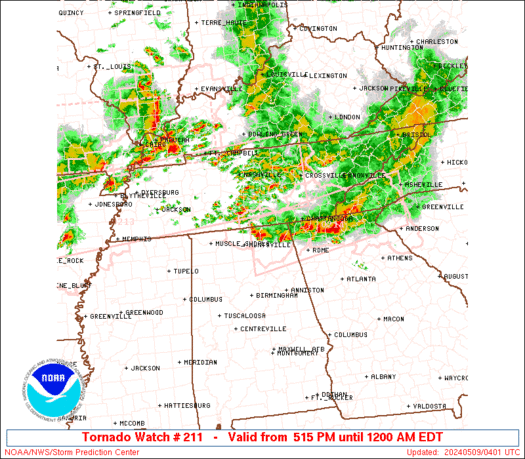
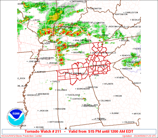
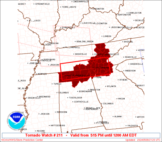
Tornado Watch Number 211
NWS Storm Prediction Center Norman OK
515 PM EDT Wed May 8 2024
The NWS Storm Prediction Center has issued a
* Tornado Watch for portions of
Northern Alabama
Northern Georgia
Far western North Carolina
Eastern Tennessee
* Effective this Wednesday afternoon from 515 PM until Midnight
EDT.
* Primary threats include...
A couple tornadoes possible
Scattered large hail likely with isolated very large hail events
to 2 inches in diameter possible
Scattered damaging wind gusts to 70 mph likely
SUMMARY...A few supercells will be possible this evening along a
remnant outflow boundary, where a couple of tornadoes will be
possible. Otherwise, additional storms could spread into this area
later this evening with an accompanying threat for damaging winds up
to 70 mph and large hail up to 2 inches in diameter.
The tornado watch area is approximately along and 40 statute miles
north and south of a line from 25 miles northwest of Muscle Shoals
AL to 75 miles east of Chattanooga TN. For a complete depiction of
the watch see the associated watch outline update (WOUS64 KWNS
WOU1).
PRECAUTIONARY/PREPAREDNESS ACTIONS...
REMEMBER...A Tornado Watch means conditions are favorable for
tornadoes and severe thunderstorms in and close to the watch
area. Persons in these areas should be on the lookout for
threatening weather conditions and listen for later statements
and possible warnings.
&&
OTHER WATCH INFORMATION...CONTINUE...WW 204...WW 205...WW
206...WW 207...WW 208...WW 209...WW 210...
AVIATION...Tornadoes and a few severe thunderstorms with hail
surface and aloft to 2 inches. Extreme turbulence and surface wind
gusts to 60 knots. A few cumulonimbi with maximum tops to 550. Mean
storm motion vector 27025.
...Thompson
   SEL1

   URGENT - IMMEDIATE BROADCAST REQUESTED
   Tornado Watch Number 211
   NWS Storm Prediction Center Norman OK
   515 PM EDT Wed May 8 2024

   The NWS Storm Prediction Center has issued a

   * Tornado Watch for portions of
     Northern Alabama
     Northern Georgia
     Far western North Carolina
     Eastern Tennessee

   * Effective this Wednesday afternoon from 515 PM until Midnight
     EDT.

   * Primary threats include...
     A couple tornadoes possible
     Scattered large hail likely with isolated very large hail events
       to 2 inches in diameter possible
     Scattered damaging wind gusts to 70 mph likely

   SUMMARY...A few supercells will be possible this evening along a
   remnant outflow boundary, where a couple of tornadoes will be
   possible.  Otherwise, additional storms could spread into this area
   later this evening with an accompanying threat for damaging winds up
   to 70 mph and large hail up to 2 inches in diameter.

   The tornado watch area is approximately along and 40 statute miles
   north and south of a line from 25 miles northwest of Muscle Shoals
   AL to 75 miles east of Chattanooga TN. For a complete depiction of
   the watch see the associated watch outline update (WOUS64 KWNS
   WOU1).

   PRECAUTIONARY/PREPAREDNESS ACTIONS...

   REMEMBER...A Tornado Watch means conditions are favorable for
   tornadoes and severe thunderstorms in and close to the watch
   area. Persons in these areas should be on the lookout for
   threatening weather conditions and listen for later statements
   and possible warnings.

   &&

   OTHER WATCH INFORMATION...CONTINUE...WW 204...WW 205...WW
   206...WW 207...WW 208...WW 209...WW 210...

   AVIATION...Tornadoes and a few severe thunderstorms with hail
   surface and aloft to 2 inches. Extreme turbulence and surface wind
   gusts to 60 knots. A few cumulonimbi with maximum tops to 550. Mean
   storm motion vector 27025.

   ...Thompson
 Note:
The Aviation Watch (SAW) product is an approximation to the watch area.
The actual watch is depicted by the shaded areas.
Note:
The Aviation Watch (SAW) product is an approximation to the watch area.
The actual watch is depicted by the shaded areas.
   SAW1
   WW 211 TORNADO AL GA NC TN 082115Z - 090400Z
   AXIS..40 STATUTE MILES NORTH AND SOUTH OF LINE..
   25NW MSL/MUSCLE SHOALS AL/ - 75E CHA/CHATTANOOGA TN/
   ..AVIATION COORDS.. 35NM N/S /29NW MSL - 34NW ODF/
   HAIL SURFACE AND ALOFT..2 INCHES. WIND GUSTS..60 KNOTS.
   MAX TOPS TO 550. MEAN STORM MOTION VECTOR 27025.

   LAT...LON 35588793 35598387 34438387 34438793

   THIS IS AN APPROXIMATION TO THE WATCH AREA.  FOR A
   COMPLETE DEPICTION OF THE WATCH SEE WOUS64 KWNS
   FOR WOU1.
Watch 211 Status Report Messages:
STATUS REPORT #6 ON WW 211

VALID 090140Z - 090240Z

THE SEVERE WEATHER THREAT CONTINUES ACROSS THE ENTIRE WATCH AREA.

..BENTLEY..05/09/24

ATTN...WFO...HUN...FFC...MRX...

&&

STATUS REPORT FOR WT 211

SEVERE WEATHER THREAT CONTINUES FOR THE FOLLOWING AREAS

ALC033-043-049-059-071-077-079-083-089-095-103-090240-

AL
.    ALABAMA COUNTIES INCLUDED ARE

COLBERT 	     CULLMAN		 DEKALB
FRANKLIN	     JACKSON		 LAUDERDALE
LAWRENCE	     LIMESTONE		 MADISON
MARSHALL	     MORGAN
$$


GAC047-055-083-085-111-123-129-187-213-227-281-291-295-311-313-
090240-

GA
.    GEORGIA COUNTIES INCLUDED ARE

CATOOSA 	     CHATTOOGA		 DADE
DAWSON		     FANNIN		 GILMER
GORDON		     LUMPKIN		 MURRAY
PICKENS 	     TOWNS		 UNION
WALKER		     WHITE		 WHITFIELD
$$


NCC039-043-090240-

NC
.    NORTH CAROLINA COUNTIES INCLUDED ARE

CHEROKEE	     CLAY
$$


TNC001-007-009-011-013-051-065-093-103-105-107-115-121-123-127-
129-139-143-145-151-153-090240-

TN
.    TENNESSEE COUNTIES INCLUDED ARE

ANDERSON	     BLEDSOE		 BLOUNT
BRADLEY 	     CAMPBELL		 FRANKLIN
HAMILTON	     KNOX		 LINCOLN
LOUDON		     MCMINN		 MARION
MEIGS		     MONROE		 MOORE
MORGAN		     POLK		 RHEA
ROANE		     SCOTT		 SEQUATCHIE
$$


THE WATCH STATUS MESSAGE IS FOR GUIDANCE PURPOSES ONLY.  PLEASE
REFER TO WATCH COUNTY NOTIFICATION STATEMENTS FOR OFFICIAL
INFORMATION ON COUNTIES...INDEPENDENT CITIES AND MARINE ZONES
CLEARED FROM SEVERE THUNDERSTORM AND TORNADO WATCHES.
$$

STATUS REPORT #5 ON WW 211

VALID 090110Z - 090240Z

THE SEVERE WEATHER THREAT CONTINUES ACROSS THE ENTIRE WATCH AREA.

..BENTLEY..05/09/24

ATTN...WFO...HUN...FFC...MRX...

&&

STATUS REPORT FOR WT 211

SEVERE WEATHER THREAT CONTINUES FOR THE FOLLOWING AREAS

ALC033-043-049-059-071-077-079-083-089-095-103-090240-

AL
.    ALABAMA COUNTIES INCLUDED ARE

COLBERT 	     CULLMAN		 DEKALB
FRANKLIN	     JACKSON		 LAUDERDALE
LAWRENCE	     LIMESTONE		 MADISON
MARSHALL	     MORGAN
$$


GAC047-055-083-085-111-123-129-187-213-227-281-291-295-311-313-
090240-

GA
.    GEORGIA COUNTIES INCLUDED ARE

CATOOSA 	     CHATTOOGA		 DADE
DAWSON		     FANNIN		 GILMER
GORDON		     LUMPKIN		 MURRAY
PICKENS 	     TOWNS		 UNION
WALKER		     WHITE		 WHITFIELD
$$


NCC039-043-090240-

NC
.    NORTH CAROLINA COUNTIES INCLUDED ARE

CHEROKEE	     CLAY
$$


TNC001-007-009-011-013-051-065-093-103-105-107-115-121-123-127-
129-139-143-145-151-153-090240-

TN
.    TENNESSEE COUNTIES INCLUDED ARE

ANDERSON	     BLEDSOE		 BLOUNT
BRADLEY 	     CAMPBELL		 FRANKLIN
HAMILTON	     KNOX		 LINCOLN
LOUDON		     MCMINN		 MARION
MEIGS		     MONROE		 MOORE
MORGAN		     POLK		 RHEA
ROANE		     SCOTT		 SEQUATCHIE
$$


THE WATCH STATUS MESSAGE IS FOR GUIDANCE PURPOSES ONLY.  PLEASE
REFER TO WATCH COUNTY NOTIFICATION STATEMENTS FOR OFFICIAL
INFORMATION ON COUNTIES...INDEPENDENT CITIES AND MARINE ZONES
CLEARED FROM SEVERE THUNDERSTORM AND TORNADO WATCHES.
$$

STATUS REPORT #4 ON WW 211

VALID 090010Z - 090140Z

THE SEVERE WEATHER THREAT CONTINUES ACROSS THE ENTIRE WATCH AREA.

..BENTLEY..05/09/24

ATTN...WFO...HUN...FFC...MRX...

&&

STATUS REPORT FOR WT 211

SEVERE WEATHER THREAT CONTINUES FOR THE FOLLOWING AREAS

ALC033-043-049-059-071-077-079-083-089-095-103-090140-

AL
.    ALABAMA COUNTIES INCLUDED ARE

COLBERT 	     CULLMAN		 DEKALB
FRANKLIN	     JACKSON		 LAUDERDALE
LAWRENCE	     LIMESTONE		 MADISON
MARSHALL	     MORGAN
$$


GAC047-055-083-085-111-123-129-187-213-227-281-291-295-311-313-
090140-

GA
.    GEORGIA COUNTIES INCLUDED ARE

CATOOSA 	     CHATTOOGA		 DADE
DAWSON		     FANNIN		 GILMER
GORDON		     LUMPKIN		 MURRAY
PICKENS 	     TOWNS		 UNION
WALKER		     WHITE		 WHITFIELD
$$


NCC039-043-090140-

NC
.    NORTH CAROLINA COUNTIES INCLUDED ARE

CHEROKEE	     CLAY
$$


TNC001-007-009-011-013-051-065-093-103-105-107-115-121-123-127-
129-139-143-145-151-153-090140-

TN
.    TENNESSEE COUNTIES INCLUDED ARE

ANDERSON	     BLEDSOE		 BLOUNT
BRADLEY 	     CAMPBELL		 FRANKLIN
HAMILTON	     KNOX		 LINCOLN
LOUDON		     MCMINN		 MARION
MEIGS		     MONROE		 MOORE
MORGAN		     POLK		 RHEA
ROANE		     SCOTT		 SEQUATCHIE
$$


THE WATCH STATUS MESSAGE IS FOR GUIDANCE PURPOSES ONLY.  PLEASE
REFER TO WATCH COUNTY NOTIFICATION STATEMENTS FOR OFFICIAL
INFORMATION ON COUNTIES...INDEPENDENT CITIES AND MARINE ZONES
CLEARED FROM SEVERE THUNDERSTORM AND TORNADO WATCHES.
$$

STATUS REPORT #3 ON WW 211

VALID 082330Z - 090040Z

THE SEVERE WEATHER THREAT CONTINUES ACROSS THE ENTIRE WATCH AREA.

..BENTLEY..05/08/24

ATTN...WFO...HUN...FFC...MRX...

&&

STATUS REPORT FOR WT 211

SEVERE WEATHER THREAT CONTINUES FOR THE FOLLOWING AREAS

ALC033-043-049-059-071-077-079-083-089-095-103-090040-

AL
.    ALABAMA COUNTIES INCLUDED ARE

COLBERT 	     CULLMAN		 DEKALB
FRANKLIN	     JACKSON		 LAUDERDALE
LAWRENCE	     LIMESTONE		 MADISON
MARSHALL	     MORGAN
$$


GAC047-055-083-085-111-123-129-187-213-227-281-291-295-311-313-
090040-

GA
.    GEORGIA COUNTIES INCLUDED ARE

CATOOSA 	     CHATTOOGA		 DADE
DAWSON		     FANNIN		 GILMER
GORDON		     LUMPKIN		 MURRAY
PICKENS 	     TOWNS		 UNION
WALKER		     WHITE		 WHITFIELD
$$


NCC039-043-090040-

NC
.    NORTH CAROLINA COUNTIES INCLUDED ARE

CHEROKEE	     CLAY
$$


TNC001-007-009-011-013-051-065-093-103-105-107-115-121-123-127-
129-139-143-145-151-153-090040-

TN
.    TENNESSEE COUNTIES INCLUDED ARE

ANDERSON	     BLEDSOE		 BLOUNT
BRADLEY 	     CAMPBELL		 FRANKLIN
HAMILTON	     KNOX		 LINCOLN
LOUDON		     MCMINN		 MARION
MEIGS		     MONROE		 MOORE
MORGAN		     POLK		 RHEA
ROANE		     SCOTT		 SEQUATCHIE
$$


THE WATCH STATUS MESSAGE IS FOR GUIDANCE PURPOSES ONLY.  PLEASE
REFER TO WATCH COUNTY NOTIFICATION STATEMENTS FOR OFFICIAL
INFORMATION ON COUNTIES...INDEPENDENT CITIES AND MARINE ZONES
CLEARED FROM SEVERE THUNDERSTORM AND TORNADO WATCHES.
$$

STATUS REPORT #2 ON WW 211

VALID 082235Z - 082340Z

THE SEVERE WEATHER THREAT CONTINUES ACROSS THE ENTIRE WATCH AREA.

..BENTLEY..05/08/24

ATTN...WFO...HUN...FFC...MRX...

&&

STATUS REPORT FOR WT 211

SEVERE WEATHER THREAT CONTINUES FOR THE FOLLOWING AREAS

ALC033-043-049-059-071-077-079-083-089-095-103-082340-

AL
.    ALABAMA COUNTIES INCLUDED ARE

COLBERT 	     CULLMAN		 DEKALB
FRANKLIN	     JACKSON		 LAUDERDALE
LAWRENCE	     LIMESTONE		 MADISON
MARSHALL	     MORGAN
$$


GAC047-055-083-085-111-123-129-187-213-227-281-291-295-311-313-
082340-

GA
.    GEORGIA COUNTIES INCLUDED ARE

CATOOSA 	     CHATTOOGA		 DADE
DAWSON		     FANNIN		 GILMER
GORDON		     LUMPKIN		 MURRAY
PICKENS 	     TOWNS		 UNION
WALKER		     WHITE		 WHITFIELD
$$


NCC039-043-082340-

NC
.    NORTH CAROLINA COUNTIES INCLUDED ARE

CHEROKEE	     CLAY
$$


TNC001-007-009-011-013-051-065-093-103-105-107-115-121-123-127-
129-139-143-145-151-153-082340-

TN
.    TENNESSEE COUNTIES INCLUDED ARE

ANDERSON	     BLEDSOE		 BLOUNT
BRADLEY 	     CAMPBELL		 FRANKLIN
HAMILTON	     KNOX		 LINCOLN
LOUDON		     MCMINN		 MARION
MEIGS		     MONROE		 MOORE
MORGAN		     POLK		 RHEA
ROANE		     SCOTT		 SEQUATCHIE
$$


THE WATCH STATUS MESSAGE IS FOR GUIDANCE PURPOSES ONLY.  PLEASE
REFER TO WATCH COUNTY NOTIFICATION STATEMENTS FOR OFFICIAL
INFORMATION ON COUNTIES...INDEPENDENT CITIES AND MARINE ZONES
CLEARED FROM SEVERE THUNDERSTORM AND TORNADO WATCHES.
$$

STATUS REPORT #1 ON WW 211

VALID 082135Z - 082240Z

THE SEVERE WEATHER THREAT CONTINUES ACROSS THE ENTIRE WATCH AREA.

..BENTLEY..05/08/24

ATTN...WFO...HUN...FFC...MRX...

&&

STATUS REPORT FOR WT 211

SEVERE WEATHER THREAT CONTINUES FOR THE FOLLOWING AREAS

ALC033-043-049-059-071-077-079-083-089-095-103-082240-

AL
.    ALABAMA COUNTIES INCLUDED ARE

COLBERT 	     CULLMAN		 DEKALB
FRANKLIN	     JACKSON		 LAUDERDALE
LAWRENCE	     LIMESTONE		 MADISON
MARSHALL	     MORGAN
$$


GAC047-055-083-085-111-123-129-187-213-227-281-291-295-311-313-
082240-

GA
.    GEORGIA COUNTIES INCLUDED ARE

CATOOSA 	     CHATTOOGA		 DADE
DAWSON		     FANNIN		 GILMER
GORDON		     LUMPKIN		 MURRAY
PICKENS 	     TOWNS		 UNION
WALKER		     WHITE		 WHITFIELD
$$


NCC039-043-082240-

NC
.    NORTH CAROLINA COUNTIES INCLUDED ARE

CHEROKEE	     CLAY
$$


TNC001-007-009-011-013-051-065-093-103-105-107-115-121-123-127-
129-139-143-145-151-153-082240-

TN
.    TENNESSEE COUNTIES INCLUDED ARE

ANDERSON	     BLEDSOE		 BLOUNT
BRADLEY 	     CAMPBELL		 FRANKLIN
HAMILTON	     KNOX		 LINCOLN
LOUDON		     MCMINN		 MARION
MEIGS		     MONROE		 MOORE
MORGAN		     POLK		 RHEA
ROANE		     SCOTT		 SEQUATCHIE
$$


THE WATCH STATUS MESSAGE IS FOR GUIDANCE PURPOSES ONLY.  PLEASE
REFER TO WATCH COUNTY NOTIFICATION STATEMENTS FOR OFFICIAL
INFORMATION ON COUNTIES...INDEPENDENT CITIES AND MARINE ZONES
CLEARED FROM SEVERE THUNDERSTORM AND TORNADO WATCHES.
$$
Note:
Click for Complete Product Text.
Tornadoes
Probability of 2 or more tornadoes
|
Mod (40%)
|
Probability of 1 or more strong (EF2-EF5) tornadoes
|
Low (20%)
|
Wind
Probability of 10 or more severe wind events
|
High (70%)
|
Probability of 1 or more wind events > 65 knots
|
Low (20%)
|
Hail
Probability of 10 or more severe hail events
|
Mod (60%)
|
Probability of 1 or more hailstones > 2 inches
|
Mod (30%)
|
Combined Severe Hail/Wind
Probability of 6 or more combined severe hail/wind events
|
High (90%)
|
For each watch, probabilities for particular events inside the watch
(listed above in each table) are determined by the issuing forecaster.
The "Low" category contains probability values ranging from less than 2%
to 20% (EF2-EF5 tornadoes), less than 5% to 20% (all other probabilities),
"Moderate" from 30% to 60%, and "High" from 70% to greater than 95%.
High values are bolded and lighter in color to provide awareness of
an increased threat for a particular event.


 @NWSSPC


