 Note:
The expiration time in the watch graphic is amended if the watch is
replaced, cancelled or extended.
Note:
Note:
The expiration time in the watch graphic is amended if the watch is
replaced, cancelled or extended.
Note: Click for
Watch Status Reports.
SEL9
URGENT - IMMEDIATE BROADCAST REQUESTED
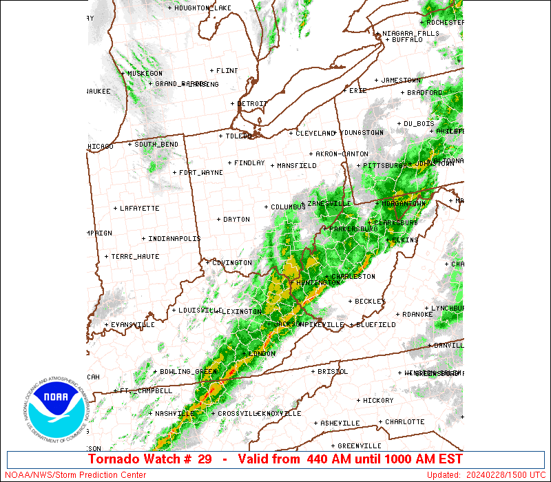
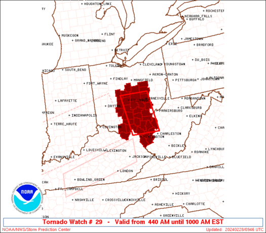
Tornado Watch Number 29
NWS Storm Prediction Center Norman OK
440 AM EST Wed Feb 28 2024
The NWS Storm Prediction Center has issued a
* Tornado Watch for portions of
parts of northeeastern Kentucky
central and southern Ohio
western West Virginia
* Effective this Wednesday morning from 440 AM until 1000 AM EST.
* Primary threats include...
A couple tornadoes possible
Isolated damaging wind gusts to 70 mph possible
SUMMARY...Strong/locally severe storms are ongoing across western
Ohio and northern Kentucky at this time, and will continue to spread
eastward over the next several hours. The storms will pose local
risk for damaging winds and hail, as well as potential for a couple
of tornadoes.
The tornado watch area is approximately along and 40 statute miles
east and west of a line from 25 miles northeast of Columbus OH to 50
miles south of Athens OH. For a complete depiction of the watch see
the associated watch outline update (WOUS64 KWNS WOU9).
PRECAUTIONARY/PREPAREDNESS ACTIONS...
REMEMBER...A Tornado Watch means conditions are favorable for
tornadoes and severe thunderstorms in and close to the watch
area. Persons in these areas should be on the lookout for
threatening weather conditions and listen for later statements
and possible warnings.
&&
OTHER WATCH INFORMATION...CONTINUE...WW 27...WW 28...
AVIATION...Tornadoes and a few severe thunderstorms with hail
surface and aloft to 1.5 inches. Extreme turbulence and surface wind
gusts to 60 knots. A few cumulonimbi with maximum tops to 400. Mean
storm motion vector 25040.
...Goss
   SEL9

   URGENT - IMMEDIATE BROADCAST REQUESTED
   Tornado Watch Number 29
   NWS Storm Prediction Center Norman OK
   440 AM EST Wed Feb 28 2024

   The NWS Storm Prediction Center has issued a

   * Tornado Watch for portions of
     parts of northeeastern Kentucky
     central and southern Ohio
     western West Virginia

   * Effective this Wednesday morning from 440 AM until 1000 AM EST.

   * Primary threats include...
     A couple tornadoes possible
     Isolated damaging wind gusts to 70 mph possible

   SUMMARY...Strong/locally severe storms are ongoing across western
   Ohio and northern Kentucky at this time, and will continue to spread
   eastward over the next several hours.  The storms will pose local
   risk for damaging winds and hail, as well as potential for a couple
   of tornadoes.

   The tornado watch area is approximately along and 40 statute miles
   east and west of a line from 25 miles northeast of Columbus OH to 50
   miles south of Athens OH. For a complete depiction of the watch see
   the associated watch outline update (WOUS64 KWNS WOU9).

   PRECAUTIONARY/PREPAREDNESS ACTIONS...

   REMEMBER...A Tornado Watch means conditions are favorable for
   tornadoes and severe thunderstorms in and close to the watch
   area. Persons in these areas should be on the lookout for
   threatening weather conditions and listen for later statements
   and possible warnings.

   &&

   OTHER WATCH INFORMATION...CONTINUE...WW 27...WW 28...

   AVIATION...Tornadoes and a few severe thunderstorms with hail
   surface and aloft to 1.5 inches. Extreme turbulence and surface wind
   gusts to 60 knots. A few cumulonimbi with maximum tops to 400. Mean
   storm motion vector 25040.

   ...Goss
 Note:
The Aviation Watch (SAW) product is an approximation to the watch area.
The actual watch is depicted by the shaded areas.
Note:
The Aviation Watch (SAW) product is an approximation to the watch area.
The actual watch is depicted by the shaded areas.
   SAW9
   WW 29 TORNADO KY OH WV 280940Z - 281500Z
   AXIS..40 STATUTE MILES EAST AND WEST OF LINE..
   25NE CMH/COLUMBUS OH/ - 50S UNI/ATHENS OH/
   ..AVIATION COORDS.. 35NM E/W /7NNE APE - 18SSW HNN/
   HAIL SURFACE AND ALOFT..1.5 INCHES. WIND GUSTS..60 KNOTS.
   MAX TOPS TO 400. MEAN STORM MOTION VECTOR 25040.

   LAT...LON 40258179 38498149 38498297 40258330

   THIS IS AN APPROXIMATION TO THE WATCH AREA.  FOR A
   COMPLETE DEPICTION OF THE WATCH SEE WOUS64 KWNS
   FOR WOU9.
Watch 29 Status Report Messages:
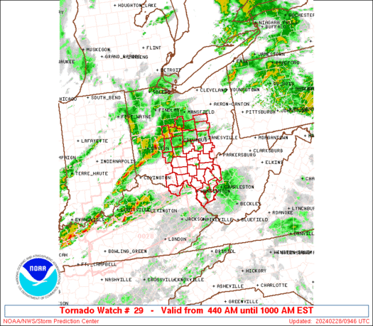
STATUS REPORT #3 ON WW 29
VALID 281420Z - 281500Z
SEVERE WEATHER THREAT CONTINUES RIGHT OF A LINE FROM 15 NW CRW TO
20 NNE CRW.
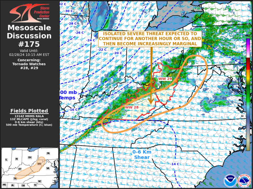
WW 29 WILL BE ALLOWED TO EXPIRE AT 281500Z.
FOR ADDITIONAL INFORMATION SEE MESOSCALE DISCUSSION 175.
..GRAMS..02/28/24
ATTN...WFO...ILN...RLX...PBZ...CLE...
&&
STATUS REPORT FOR WT 29
SEVERE WEATHER THREAT CONTINUES FOR THE FOLLOWING AREAS
WVC005-039-043-045-059-099-281500-
WV
. WEST VIRGINIA COUNTIES INCLUDED ARE
BOONE KANAWHA LINCOLN
LOGAN MINGO WAYNE
$$
THE WATCH STATUS MESSAGE IS FOR GUIDANCE PURPOSES ONLY. PLEASE
REFER TO WATCH COUNTY NOTIFICATION STATEMENTS FOR OFFICIAL
INFORMATION ON COUNTIES...INDEPENDENT CITIES AND MARINE ZONES
CLEARED FROM SEVERE THUNDERSTORM AND TORNADO WATCHES.
$$
STATUS REPORT #2 ON WW 29
VALID 281130Z - 281240Z
SEVERE WEATHER THREAT CONTINUES RIGHT OF A LINE FROM 45 SE DAY TO
20 ESE CMH TO 35 SW CAK.
..BROYLES..02/28/24
ATTN...WFO...ILN...RLX...PBZ...CLE...
&&
STATUS REPORT FOR WT 29
SEVERE WEATHER THREAT CONTINUES FOR THE FOLLOWING AREAS
KYC135-281240-
KY
. KENTUCKY COUNTIES INCLUDED ARE
LEWIS
$$
OHC001-009-031-045-053-073-079-087-105-115-119-127-129-131-141-
145-163-281240-
OH
. OHIO COUNTIES INCLUDED ARE
ADAMS ATHENS COSHOCTON
FAIRFIELD GALLIA HOCKING
JACKSON LAWRENCE MEIGS
MORGAN MUSKINGUM PERRY
PICKAWAY PIKE ROSS
SCIOTO VINTON
$$
WVC011-035-043-053-079-099-281240-
WV
. WEST VIRGINIA COUNTIES INCLUDED ARE
CABELL JACKSON LINCOLN
MASON PUTNAM WAYNE
$$
THE WATCH STATUS MESSAGE IS FOR GUIDANCE PURPOSES ONLY. PLEASE
REFER TO WATCH COUNTY NOTIFICATION STATEMENTS FOR OFFICIAL
INFORMATION ON COUNTIES...INDEPENDENT CITIES AND MARINE ZONES
CLEARED FROM SEVERE THUNDERSTORM AND TORNADO WATCHES.
$$
STATUS REPORT #1 ON WW 29
VALID 281030Z - 281140Z
THE SEVERE WEATHER THREAT CONTINUES ACROSS THE ENTIRE WATCH AREA.
..BROYLES..02/28/24
ATTN...WFO...ILN...RLX...PBZ...CLE...
&&
STATUS REPORT FOR WT 29
SEVERE WEATHER THREAT CONTINUES FOR THE FOLLOWING AREAS
KYC135-281140-
KY
. KENTUCKY COUNTIES INCLUDED ARE
LEWIS
$$
OHC001-009-031-041-045-047-049-053-073-075-079-083-087-089-097-
105-115-117-119-127-129-131-141-145-159-163-281140-
OH
. OHIO COUNTIES INCLUDED ARE
ADAMS ATHENS COSHOCTON
DELAWARE FAIRFIELD FAYETTE
FRANKLIN GALLIA HOCKING
HOLMES JACKSON KNOX
LAWRENCE LICKING MADISON
MEIGS MORGAN MORROW
MUSKINGUM PERRY PICKAWAY
PIKE ROSS SCIOTO
UNION VINTON
$$
WVC011-035-043-053-079-099-281140-
WV
. WEST VIRGINIA COUNTIES INCLUDED ARE
CABELL JACKSON LINCOLN
MASON PUTNAM WAYNE
$$
THE WATCH STATUS MESSAGE IS FOR GUIDANCE PURPOSES ONLY. PLEASE
REFER TO WATCH COUNTY NOTIFICATION STATEMENTS FOR OFFICIAL
INFORMATION ON COUNTIES...INDEPENDENT CITIES AND MARINE ZONES
CLEARED FROM SEVERE THUNDERSTORM AND TORNADO WATCHES.
$$
Note:
Click for Complete Product Text.
Tornadoes
Probability of 2 or more tornadoes
|
Mod (30%)
|
Probability of 1 or more strong (EF2-EF5) tornadoes
|
Low (10%)
|
Wind
Probability of 10 or more severe wind events
|
Low (20%)
|
Probability of 1 or more wind events > 65 knots
|
Low (10%)
|
Hail
Probability of 10 or more severe hail events
|
Low (10%)
|
Probability of 1 or more hailstones > 2 inches
|
Low (<5%)
|
Combined Severe Hail/Wind
Probability of 6 or more combined severe hail/wind events
|
Mod (50%)
|
For each watch, probabilities for particular events inside the watch
(listed above in each table) are determined by the issuing forecaster.
The "Low" category contains probability values ranging from less than 2%
to 20% (EF2-EF5 tornadoes), less than 5% to 20% (all other probabilities),
"Moderate" from 30% to 60%, and "High" from 70% to greater than 95%.
High values are bolded and lighter in color to provide awareness of
an increased threat for a particular event.


 @NWSSPC