 Note:
The expiration time in the watch graphic is amended if the watch is
replaced, cancelled or extended.
Note:
Note:
The expiration time in the watch graphic is amended if the watch is
replaced, cancelled or extended.
Note: Click for
Watch Status Reports.
SEL0
URGENT - IMMEDIATE BROADCAST REQUESTED
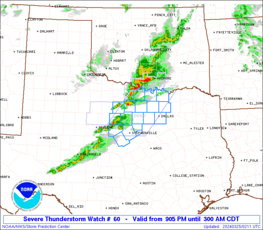
Severe Thunderstorm Watch Number 60
NWS Storm Prediction Center Norman OK
905 PM CDT Sun Mar 24 2024
The NWS Storm Prediction Center has issued a
* Severe Thunderstorm Watch for portions of
North Texas
* Effective this Sunday night and Monday morning from 905 PM
until 300 AM CDT.
* Primary threats include...
Scattered large hail and isolated very large hail events to 2
inches in diameter possible
Scattered damaging wind gusts to 65 mph possible
A tornado or two possible
SUMMARY...Strong to severe storms are expected to persist across
parts of North Texas through the late evening and overnight hours,
with some additional development and intensification possible
southwestward toward central Texas later this evening.
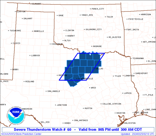
The severe thunderstorm watch area is approximately along and 60
statute miles east and west of a line from 25 miles west northwest
of Sherman TX to 20 miles west southwest of Stephenville TX. For a
complete depiction of the watch see the associated watch outline
update (WOUS64 KWNS WOU0).
PRECAUTIONARY/PREPAREDNESS ACTIONS...
REMEMBER...A Severe Thunderstorm Watch means conditions are
favorable for severe thunderstorms in and close to the watch area.
Persons in these areas should be on the lookout for threatening
weather conditions and listen for later statements and possible
warnings. Severe thunderstorms can and occasionally do produce
tornadoes.
&&
OTHER WATCH INFORMATION...CONTINUE...WW 59...
AVIATION...A few severe thunderstorms with hail surface and aloft to
2 inches. Extreme turbulence and surface wind gusts to 55 knots. A
few cumulonimbi with maximum tops to 450. Mean storm motion vector
25025.
...Guyer
   SEL0

   URGENT - IMMEDIATE BROADCAST REQUESTED
   Severe Thunderstorm Watch Number 60
   NWS Storm Prediction Center Norman OK
   905 PM CDT Sun Mar 24 2024

   The NWS Storm Prediction Center has issued a

   * Severe Thunderstorm Watch for portions of
     North Texas

   * Effective this Sunday night and Monday morning from 905 PM
     until 300 AM CDT.

   * Primary threats include...
     Scattered large hail and isolated very large hail events to 2
       inches in diameter possible
     Scattered damaging wind gusts to 65 mph possible
     A tornado or two possible

   SUMMARY...Strong to severe storms are expected to persist across
   parts of North Texas through the late evening and overnight hours,
   with some additional development and intensification possible
   southwestward toward central Texas later this evening.

   The severe thunderstorm watch area is approximately along and 60
   statute miles east and west of a line from 25 miles west northwest
   of Sherman TX to 20 miles west southwest of Stephenville TX. For a
   complete depiction of the watch see the associated watch outline
   update (WOUS64 KWNS WOU0).

   PRECAUTIONARY/PREPAREDNESS ACTIONS...

   REMEMBER...A Severe Thunderstorm Watch means conditions are
   favorable for severe thunderstorms in and close to the watch area.
   Persons in these areas should be on the lookout for threatening
   weather conditions and listen for later statements and possible
   warnings. Severe thunderstorms can and occasionally do produce
   tornadoes.

   &&

   OTHER WATCH INFORMATION...CONTINUE...WW 59...

   AVIATION...A few severe thunderstorms with hail surface and aloft to
   2 inches. Extreme turbulence and surface wind gusts to 55 knots. A
   few cumulonimbi with maximum tops to 450. Mean storm motion vector
   25025.

   ...Guyer
 Note:
The Aviation Watch (SAW) product is an approximation to the watch area.
The actual watch is depicted by the shaded areas.
Note:
The Aviation Watch (SAW) product is an approximation to the watch area.
The actual watch is depicted by the shaded areas.
   SAW0
   WW 60 SEVERE TSTM TX 250205Z - 250800Z
   AXIS..60 STATUTE MILES EAST AND WEST OF LINE..
   25WNW GYI/SHERMAN TX/ - 20WSW SEP/STEPHENVILLE TX/
   ..AVIATION COORDS.. 50NM E/W /22SSE ADM - 68WNW ACT/
   HAIL SURFACE AND ALOFT..2 INCHES. WIND GUSTS..55 KNOTS.
   MAX TOPS TO 450. MEAN STORM MOTION VECTOR 25025.

   LAT...LON 33849603 32099747 32099952 33849812

   THIS IS AN APPROXIMATION TO THE WATCH AREA.  FOR A
   COMPLETE DEPICTION OF THE WATCH SEE WOUS64 KWNS
   FOR WOU0.
Watch 60 Status Report Messages:
STATUS REPORT #2 ON WW 60

VALID 250610Z - 250740Z

SEVERE WEATHER THREAT CONTINUES RIGHT OF A LINE FROM 25 SE SEP TO
20 NW DAL TO 5 NE DUA.

..WENDT..03/25/24

ATTN...WFO...FWD...

&&

STATUS REPORT FOR WS 60

SEVERE WEATHER THREAT CONTINUES FOR THE FOLLOWING AREAS

TXC085-113-181-439-250740-

TX
.    TEXAS COUNTIES INCLUDED ARE

COLLIN		     DALLAS		 GRAYSON
TARRANT
$$


THE WATCH STATUS MESSAGE IS FOR GUIDANCE PURPOSES ONLY.  PLEASE
REFER TO WATCH COUNTY NOTIFICATION STATEMENTS FOR OFFICIAL
INFORMATION ON COUNTIES...INDEPENDENT CITIES AND MARINE ZONES
CLEARED FROM SEVERE THUNDERSTORM AND TORNADO WATCHES.
$$

STATUS REPORT #1 ON WW 60

VALID 250400Z - 250540Z

SEVERE WEATHER THREAT CONTINUES RIGHT OF A LINE FROM 25 WNW BWD
TO 15 NNW MWL TO 45 E SPS.

..BROYLES..03/25/24

ATTN...WFO...FWD...

&&

STATUS REPORT FOR WS 60

SEVERE WEATHER THREAT CONTINUES FOR THE FOLLOWING AREAS

TXC085-093-097-113-121-133-143-181-221-337-363-367-425-439-497-
250540-

TX
.    TEXAS COUNTIES INCLUDED ARE

COLLIN		     COMANCHE		 COOKE
DALLAS		     DENTON		 EASTLAND
ERATH		     GRAYSON		 HOOD
MONTAGUE	     PALO PINTO 	 PARKER
SOMERVELL	     TARRANT		 WISE
$$


THE WATCH STATUS MESSAGE IS FOR GUIDANCE PURPOSES ONLY.  PLEASE
REFER TO WATCH COUNTY NOTIFICATION STATEMENTS FOR OFFICIAL
INFORMATION ON COUNTIES...INDEPENDENT CITIES AND MARINE ZONES
CLEARED FROM SEVERE THUNDERSTORM AND TORNADO WATCHES.
$$
Note:
Click for Complete Product Text.
Tornadoes
Probability of 2 or more tornadoes
|
Low (20%)
|
Probability of 1 or more strong (EF2-EF5) tornadoes
|
Low (5%)
|
Wind
Probability of 10 or more severe wind events
|
Mod (40%)
|
Probability of 1 or more wind events > 65 knots
|
Low (10%)
|
Hail
Probability of 10 or more severe hail events
|
Mod (40%)
|
Probability of 1 or more hailstones > 2 inches
|
Mod (30%)
|
Combined Severe Hail/Wind
Probability of 6 or more combined severe hail/wind events
|
High (70%)
|
For each watch, probabilities for particular events inside the watch
(listed above in each table) are determined by the issuing forecaster.
The "Low" category contains probability values ranging from less than 2%
to 20% (EF2-EF5 tornadoes), less than 5% to 20% (all other probabilities),
"Moderate" from 30% to 60%, and "High" from 70% to greater than 95%.
High values are bolded and lighter in color to provide awareness of
an increased threat for a particular event.


 @NWSSPC


