Note:
The expiration time in the watch graphic is amended if the watch is
replaced, cancelled or extended.
Note:
Note:
The expiration time in the watch graphic is amended if the watch is
replaced, cancelled or extended.
Note: Click for
Watch Status Reports.
SEL6
URGENT - IMMEDIATE BROADCAST REQUESTED
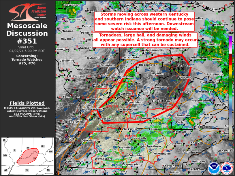
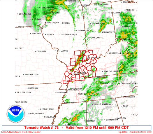
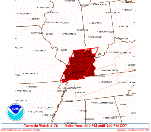
Tornado Watch Number 76
NWS Storm Prediction Center Norman OK
1210 PM CDT Tue Apr 2 2024
The NWS Storm Prediction Center has issued a
* Tornado Watch for portions of
Southeast Illinois
Southwest Indiana
Western Kentucky
Extreme southeast Missouri
* Effective this Tuesday afternoon and evening from 1210 PM until
600 PM CDT.
* Primary threats include...
A few tornadoes likely with a couple intense tornadoes possible
Scattered large hail and isolated very large hail events to 2
inches in diameter likely
Scattered damaging winds likely with isolated significant gusts
to 75 mph possible
SUMMARY...Scattered supercell development is expected along a wind
shift from extreme southeast Missouri into southeast Illinois early
this afternoon, and additional storms will form and move into
western Kentucky and southwest Indiana through the afternoon. The
environment favors fast-moving supercells capable of producing
tornadoes (a couple of which could be strong/EF2), large hail of 1-2
inches in diameter, and damaging gusts of 60-75 mph.
The tornado watch area is approximately along and 60 statute miles
east and west of a line from 40 miles north of Evansville IN to 40
miles south southwest of Paducah KY. For a complete depiction of the
watch see the associated watch outline update (WOUS64 KWNS WOU6).
PRECAUTIONARY/PREPAREDNESS ACTIONS...
REMEMBER...A Tornado Watch means conditions are favorable for
tornadoes and severe thunderstorms in and close to the watch
area. Persons in these areas should be on the lookout for
threatening weather conditions and listen for later statements
and possible warnings.
&&
OTHER WATCH INFORMATION...CONTINUE...WW 75...
AVIATION...Tornadoes and a few severe thunderstorms with hail
surface and aloft to 2 inches. Extreme turbulence and surface wind
gusts to 65 knots. A few cumulonimbi with maximum tops to 500. Mean
storm motion vector 24050.
...Thompson
   SEL6

   URGENT - IMMEDIATE BROADCAST REQUESTED
   Tornado Watch Number 76
   NWS Storm Prediction Center Norman OK
   1210 PM CDT Tue Apr 2 2024

   The NWS Storm Prediction Center has issued a

   * Tornado Watch for portions of
     Southeast Illinois
     Southwest Indiana
     Western Kentucky
     Extreme southeast Missouri

   * Effective this Tuesday afternoon and evening from 1210 PM until
     600 PM CDT.

   * Primary threats include...
     A few tornadoes likely with a couple intense tornadoes possible
     Scattered large hail and isolated very large hail events to 2
       inches in diameter likely
     Scattered damaging winds likely with isolated significant gusts
       to 75 mph possible

   SUMMARY...Scattered supercell development is expected along a wind
   shift from extreme southeast Missouri into southeast Illinois early
   this afternoon, and additional storms will form and move into
   western Kentucky and southwest Indiana through the afternoon.  The
   environment favors fast-moving supercells capable of producing
   tornadoes (a couple of which could be strong/EF2), large hail of 1-2
   inches in diameter, and damaging gusts of 60-75 mph.

   The tornado watch area is approximately along and 60 statute miles
   east and west of a line from 40 miles north of Evansville IN to 40
   miles south southwest of Paducah KY. For a complete depiction of the
   watch see the associated watch outline update (WOUS64 KWNS WOU6).

   PRECAUTIONARY/PREPAREDNESS ACTIONS...

   REMEMBER...A Tornado Watch means conditions are favorable for
   tornadoes and severe thunderstorms in and close to the watch
   area. Persons in these areas should be on the lookout for
   threatening weather conditions and listen for later statements
   and possible warnings.

   &&

   OTHER WATCH INFORMATION...CONTINUE...WW 75...

   AVIATION...Tornadoes and a few severe thunderstorms with hail
   surface and aloft to 2 inches. Extreme turbulence and surface wind
   gusts to 65 knots. A few cumulonimbi with maximum tops to 500. Mean
   storm motion vector 24050.

   ...Thompson
 Note:
The Aviation Watch (SAW) product is an approximation to the watch area.
The actual watch is depicted by the shaded areas.
Note:
The Aviation Watch (SAW) product is an approximation to the watch area.
The actual watch is depicted by the shaded areas.
   SAW6
   WW 76 TORNADO IL IN KY MO 021710Z - 022300Z
   AXIS..60 STATUTE MILES EAST AND WEST OF LINE..
   40N EVV/EVANSVILLE IN/ - 40SSW PAH/PADUCAH KY/
   ..AVIATION COORDS.. 50NM E/W /42NNE PXV - 34NNE DYR/
   HAIL SURFACE AND ALOFT..2 INCHES. WIND GUSTS..65 KNOTS.
   MAX TOPS TO 500. MEAN STORM MOTION VECTOR 24050.

   LAT...LON 38598642 36538797 36539013 38598864

   THIS IS AN APPROXIMATION TO THE WATCH AREA.  FOR A
   COMPLETE DEPICTION OF THE WATCH SEE WOUS64 KWNS
   FOR WOU6.
Watch 76 Status Report Messages:
STATUS REPORT #4 ON WW 76

VALID 022115Z - 022240Z

SEVERE WEATHER THREAT CONTINUES RIGHT OF A LINE FROM 35 SSE PAH
TO 35 SSW EVV TO 35 S BMG.

..LYONS..04/02/24

ATTN...WFO...PAH...

&&

STATUS REPORT FOR WT 76

SEVERE WEATHER THREAT CONTINUES FOR THE FOLLOWING AREAS

KYC033-035-047-059-107-143-149-157-177-219-221-233-022240-

KY
.    KENTUCKY COUNTIES INCLUDED ARE

CALDWELL	     CALLOWAY		 CHRISTIAN
DAVIESS 	     HOPKINS		 LYON
MCLEAN		     MARSHALL		 MUHLENBERG
TODD		     TRIGG		 WEBSTER
$$


THE WATCH STATUS MESSAGE IS FOR GUIDANCE PURPOSES ONLY.  PLEASE
REFER TO WATCH COUNTY NOTIFICATION STATEMENTS FOR OFFICIAL
INFORMATION ON COUNTIES...INDEPENDENT CITIES AND MARINE ZONES
CLEARED FROM SEVERE THUNDERSTORM AND TORNADO WATCHES.
$$

STATUS REPORT #3 ON WW 76

VALID 022015Z - 022140Z

SEVERE WEATHER THREAT CONTINUES RIGHT OF A LINE FROM 40 SSW PAH
TO 25 W EVV TO 50 S HUF.

..LYONS..04/02/24

ATTN...WFO...PAH...

&&

STATUS REPORT FOR WT 76

SEVERE WEATHER THREAT CONTINUES FOR THE FOLLOWING AREAS

INC051-125-129-147-163-173-022140-

IN
.    INDIANA COUNTIES INCLUDED ARE

GIBSON		     PIKE		 POSEY
SPENCER 	     VANDERBURGH	 WARRICK
$$


KYC033-035-039-047-055-059-083-101-105-107-139-143-149-157-177-
219-221-225-233-022140-

KY
.    KENTUCKY COUNTIES INCLUDED ARE

CALDWELL	     CALLOWAY		 CARLISLE
CHRISTIAN	     CRITTENDEN 	 DAVIESS
GRAVES		     HENDERSON		 HICKMAN
HOPKINS 	     LIVINGSTON 	 LYON
MCLEAN		     MARSHALL		 MUHLENBERG
TODD		     TRIGG		 UNION
WEBSTER
$$


THE WATCH STATUS MESSAGE IS FOR GUIDANCE PURPOSES ONLY.  PLEASE
REFER TO WATCH COUNTY NOTIFICATION STATEMENTS FOR OFFICIAL
INFORMATION ON COUNTIES...INDEPENDENT CITIES AND MARINE ZONES
CLEARED FROM SEVERE THUNDERSTORM AND TORNADO WATCHES.
$$

STATUS REPORT #2 ON WW 76

VALID 021905Z - 022040Z

SEVERE WEATHER THREAT CONTINUES RIGHT OF A LINE FROM 35 ESE POF
TO 25 S MDH TO 20 ESE MVN TO 40 E SLO.

..LYONS..04/02/24

ATTN...WFO...PAH...

&&

STATUS REPORT FOR WT 76

SEVERE WEATHER THREAT CONTINUES FOR THE FOLLOWING AREAS

ILC047-059-065-069-127-151-165-185-193-022040-

IL
.    ILLINOIS COUNTIES INCLUDED ARE

EDWARDS 	     GALLATIN		 HAMILTON
HARDIN		     MASSAC		 POPE
SALINE		     WABASH		 WHITE
$$


INC051-125-129-147-163-173-022040-

IN
.    INDIANA COUNTIES INCLUDED ARE

GIBSON		     PIKE		 POSEY
SPENCER 	     VANDERBURGH	 WARRICK
$$


KYC007-033-035-039-047-055-059-075-083-101-105-107-139-143-145-
149-157-177-219-221-225-233-022040-

KY
.    KENTUCKY COUNTIES INCLUDED ARE

BALLARD 	     CALDWELL		 CALLOWAY
CARLISLE	     CHRISTIAN		 CRITTENDEN
DAVIESS 	     FULTON		 GRAVES
HENDERSON	     HICKMAN		 HOPKINS
LIVINGSTON	     LYON		 MCCRACKEN
MCLEAN		     MARSHALL		 MUHLENBERG
TODD		     TRIGG		 UNION
WEBSTER
$$


MOC143-022040-

MO
.    MISSOURI COUNTIES INCLUDED ARE

NEW MADRID
$$


THE WATCH STATUS MESSAGE IS FOR GUIDANCE PURPOSES ONLY.  PLEASE
REFER TO WATCH COUNTY NOTIFICATION STATEMENTS FOR OFFICIAL
INFORMATION ON COUNTIES...INDEPENDENT CITIES AND MARINE ZONES
CLEARED FROM SEVERE THUNDERSTORM AND TORNADO WATCHES.
$$

STATUS REPORT #1 ON WW 76

VALID 021735Z - 021840Z

THE SEVERE WEATHER THREAT CONTINUES ACROSS THE ENTIRE WATCH AREA.

..LYONS..04/02/24

ATTN...WFO...PAH...

&&

STATUS REPORT FOR WT 76

SEVERE WEATHER THREAT CONTINUES FOR THE FOLLOWING AREAS

ILC003-047-055-059-065-069-087-127-151-153-165-181-185-191-193-
199-021840-

IL
.    ILLINOIS COUNTIES INCLUDED ARE

ALEXANDER	     EDWARDS		 FRANKLIN
GALLATIN	     HAMILTON		 HARDIN
JOHNSON 	     MASSAC		 POPE
PULASKI 	     SALINE		 UNION
WABASH		     WAYNE		 WHITE
WILLIAMSON
$$


INC051-125-129-147-163-173-021840-

IN
.    INDIANA COUNTIES INCLUDED ARE

GIBSON		     PIKE		 POSEY
SPENCER 	     VANDERBURGH	 WARRICK
$$


KYC007-033-035-039-047-055-059-075-083-101-105-107-139-143-145-
149-157-177-219-221-225-233-021840-

KY
.    KENTUCKY COUNTIES INCLUDED ARE

BALLARD 	     CALDWELL		 CALLOWAY
CARLISLE	     CHRISTIAN		 CRITTENDEN
DAVIESS 	     FULTON		 GRAVES
HENDERSON	     HICKMAN		 HOPKINS
LIVINGSTON	     LYON		 MCCRACKEN
MCLEAN		     MARSHALL		 MUHLENBERG
TODD		     TRIGG		 UNION
WEBSTER
$$


MOC133-143-201-021840-

MO
.    MISSOURI COUNTIES INCLUDED ARE

MISSISSIPPI	     NEW MADRID 	 SCOTT
$$


THE WATCH STATUS MESSAGE IS FOR GUIDANCE PURPOSES ONLY.  PLEASE
REFER TO WATCH COUNTY NOTIFICATION STATEMENTS FOR OFFICIAL
INFORMATION ON COUNTIES...INDEPENDENT CITIES AND MARINE ZONES
CLEARED FROM SEVERE THUNDERSTORM AND TORNADO WATCHES.
$$
Note:
Click for Complete Product Text.
Tornadoes
Probability of 2 or more tornadoes
|
Mod (60%)
|
Probability of 1 or more strong (EF2-EF5) tornadoes
|
Mod (30%)
|
Wind
Probability of 10 or more severe wind events
|
Mod (60%)
|
Probability of 1 or more wind events > 65 knots
|
Mod (30%)
|
Hail
Probability of 10 or more severe hail events
|
Mod (60%)
|
Probability of 1 or more hailstones > 2 inches
|
Mod (60%)
|
Combined Severe Hail/Wind
Probability of 6 or more combined severe hail/wind events
|
High (>95%)
|
For each watch, probabilities for particular events inside the watch
(listed above in each table) are determined by the issuing forecaster.
The "Low" category contains probability values ranging from less than 2%
to 20% (EF2-EF5 tornadoes), less than 5% to 20% (all other probabilities),
"Moderate" from 30% to 60%, and "High" from 70% to greater than 95%.
High values are bolded and lighter in color to provide awareness of
an increased threat for a particular event.


 @NWSSPC