 Note:
The expiration time in the watch graphic is amended if the watch is
replaced, cancelled or extended.
Note:
Note:
The expiration time in the watch graphic is amended if the watch is
replaced, cancelled or extended.
Note: Click for
Watch Status Reports.
SEL8
URGENT - IMMEDIATE BROADCAST REQUESTED
Tornado Watch Number 158
NWS Storm Prediction Center Norman OK
225 PM CDT Sun Apr 28 2024
The NWS Storm Prediction Center has issued a
* Tornado Watch for portions of
East Texas
* Effective this Sunday afternoon and evening from 225 PM until
900 PM CDT.
* Primary threats include...
A couple tornadoes possible
Scattered damaging wind gusts to 70 mph likely
Scattered large hail and isolated very large hail events to 2
inches in diameter possible
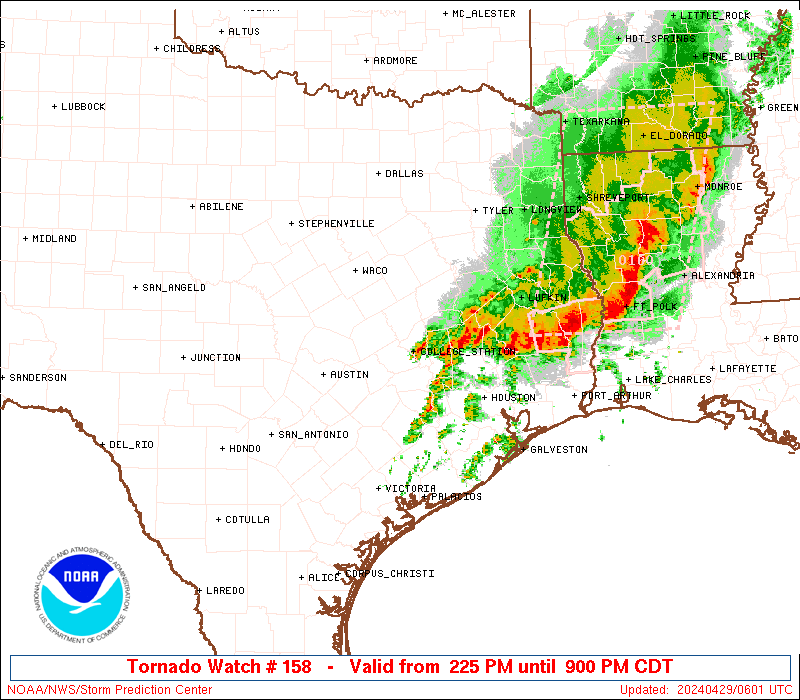
SUMMARY...Thunderstorms will continue to intensify and spread slowly
eastward across the watch area this afternoon. A few storms may
become supercellular, posing a risk of large hail, damaging wind
gusts, and a few tornadoes.
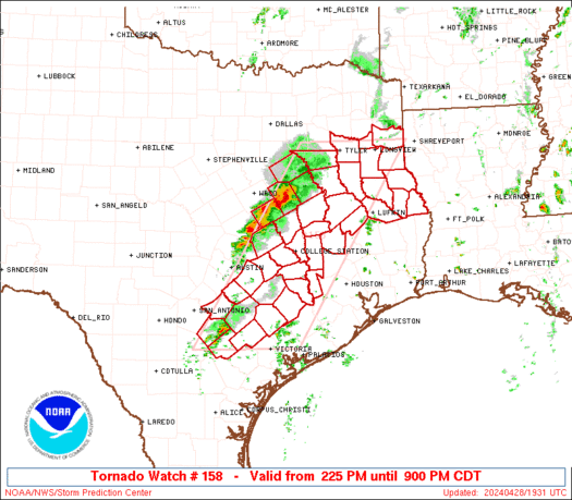
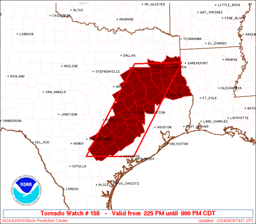
The tornado watch area is approximately along and 65 statute miles
east and west of a line from 30 miles west of Victoria TX to 25
miles west northwest of Longview TX. For a complete depiction of the
watch see the associated watch outline update (WOUS64 KWNS WOU8).
PRECAUTIONARY/PREPAREDNESS ACTIONS...
REMEMBER...A Tornado Watch means conditions are favorable for
tornadoes and severe thunderstorms in and close to the watch
area. Persons in these areas should be on the lookout for
threatening weather conditions and listen for later statements
and possible warnings.
&&
AVIATION...Tornadoes and a few severe thunderstorms with hail
surface and aloft to 2 inches. Extreme turbulence and surface wind
gusts to 60 knots. A few cumulonimbi with maximum tops to 500. Mean
storm motion vector 25035.
...Hart

   SEL8

   URGENT - IMMEDIATE BROADCAST REQUESTED
   Tornado Watch Number 158
   NWS Storm Prediction Center Norman OK
   225 PM CDT Sun Apr 28 2024

   The NWS Storm Prediction Center has issued a

   * Tornado Watch for portions of
     East Texas

   * Effective this Sunday afternoon and evening from 225 PM until
     900 PM CDT.

   * Primary threats include...
     A couple tornadoes possible
     Scattered damaging wind gusts to 70 mph likely
     Scattered large hail and isolated very large hail events to 2
       inches in diameter possible

   SUMMARY...Thunderstorms will continue to intensify and spread slowly
   eastward across the watch area this afternoon.  A few storms may
   become supercellular, posing a risk of large hail, damaging wind
   gusts, and a few tornadoes.

   The tornado watch area is approximately along and 65 statute miles
   east and west of a line from 30 miles west of Victoria TX to 25
   miles west northwest of Longview TX. For a complete depiction of the
   watch see the associated watch outline update (WOUS64 KWNS WOU8).

   PRECAUTIONARY/PREPAREDNESS ACTIONS...

   REMEMBER...A Tornado Watch means conditions are favorable for
   tornadoes and severe thunderstorms in and close to the watch
   area. Persons in these areas should be on the lookout for
   threatening weather conditions and listen for later statements
   and possible warnings.

   &&

   AVIATION...Tornadoes and a few severe thunderstorms with hail
   surface and aloft to 2 inches. Extreme turbulence and surface wind
   gusts to 60 knots. A few cumulonimbi with maximum tops to 500. Mean
   storm motion vector 25035.

   ...Hart
 Note:
The Aviation Watch (SAW) product is an approximation to the watch area.
The actual watch is depicted by the shaded areas.
Note:
The Aviation Watch (SAW) product is an approximation to the watch area.
The actual watch is depicted by the shaded areas.
   SAW8
   WW 158 TORNADO TX 281925Z - 290200Z
   AXIS..65 STATUTE MILES EAST AND WEST OF LINE..
   30W VCT/VICTORIA TX/ - 25WNW GGG/LONGVIEW TX/
   ..AVIATION COORDS.. 55NM E/W /57N CRP - 19WNW GGG/
   HAIL SURFACE AND ALOFT..2 INCHES. WIND GUSTS..60 KNOTS.
   MAX TOPS TO 500. MEAN STORM MOTION VECTOR 25035.

   LAT...LON 28849849 32509623 32509400 28849634

   THIS IS AN APPROXIMATION TO THE WATCH AREA.  FOR A
   COMPLETE DEPICTION OF THE WATCH SEE WOUS64 KWNS
   FOR WOU8.
Watch 158 Status Report Messages:
STATUS REPORT #1 ON WW 158

VALID 282030Z - 282140Z

THE SEVERE WEATHER THREAT CONTINUES ACROSS THE ENTIRE WATCH AREA.

..GRAMS..04/28/24

ATTN...WFO...FWD...SHV...HGX...EWX...

&&

STATUS REPORT FOR WT 158

SEVERE WEATHER THREAT CONTINUES FOR THE FOLLOWING AREAS

TXC001-005-015-021-041-051-055-073-089-123-145-149-161-177-183-
185-187-203-213-225-255-285-287-289-293-313-331-347-349-365-395-
401-403-405-419-423-455-471-473-477-493-282140-

TX
.    TEXAS COUNTIES INCLUDED ARE

ANDERSON	     ANGELINA		 AUSTIN
BASTROP 	     BRAZOS		 BURLESON
CALDWELL	     CHEROKEE		 COLORADO
DEWITT		     FALLS		 FAYETTE
FREESTONE	     GONZALES		 GREGG
GRIMES		     GUADALUPE		 HARRISON
HENDERSON	     HOUSTON		 KARNES
LAVACA		     LEE		 LEON
LIMESTONE	     MADISON		 MILAM
NACOGDOCHES	     NAVARRO		 PANOLA
ROBERTSON	     RUSK		 SABINE
SAN AUGUSTINE	     SHELBY		 SMITH
TRINITY 	     WALKER		 WALLER
WASHINGTON	     WILSON
$$


THE WATCH STATUS MESSAGE IS FOR GUIDANCE PURPOSES ONLY.  PLEASE
REFER TO WATCH COUNTY NOTIFICATION STATEMENTS FOR OFFICIAL
INFORMATION ON COUNTIES...INDEPENDENT CITIES AND MARINE ZONES
CLEARED FROM SEVERE THUNDERSTORM AND TORNADO WATCHES.
$$
Note:
Click for Complete Product Text.
Tornadoes
Probability of 2 or more tornadoes
|
Mod (40%)
|
Probability of 1 or more strong (EF2-EF5) tornadoes
|
Low (20%)
|
Wind
Probability of 10 or more severe wind events
|
Mod (60%)
|
Probability of 1 or more wind events > 65 knots
|
Low (20%)
|
Hail
Probability of 10 or more severe hail events
|
Mod (40%)
|
Probability of 1 or more hailstones > 2 inches
|
Mod (30%)
|
Combined Severe Hail/Wind
Probability of 6 or more combined severe hail/wind events
|
High (90%)
|
For each watch, probabilities for particular events inside the watch
(listed above in each table) are determined by the issuing forecaster.
The "Low" category contains probability values ranging from less than 2%
to 20% (EF2-EF5 tornadoes), less than 5% to 20% (all other probabilities),
"Moderate" from 30% to 60%, and "High" from 70% to greater than 95%.
High values are bolded and lighter in color to provide awareness of
an increased threat for a particular event.


 @NWSSPC