 Note:
The expiration time in the watch graphic is amended if the watch is
replaced, cancelled or extended.
Note:
Note:
The expiration time in the watch graphic is amended if the watch is
replaced, cancelled or extended.
Note: Click for
Watch Status Reports.
SEL8
URGENT - IMMEDIATE BROADCAST REQUESTED
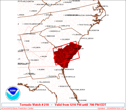
Tornado Watch Number 218
NWS Storm Prediction Center Norman OK
1210 PM EDT Thu May 9 2024
The NWS Storm Prediction Center has issued a
* Tornado Watch for portions of
Southeast Georgia
Southern South Carolina
Coastal Waters
* Effective this Thursday afternoon and evening from 1210 PM
until 700 PM EDT.
* Primary threats include...
A couple tornadoes possible
Scattered damaging wind gusts to 70 mph likely
Isolated large hail events to 1.5 inches in diameter possible
SUMMARY...Intensifying bands of storms will move into the Watch area
this afternoon and into the early evening. The stronger storms will
probably include a mix of line segments and a few supercells. The
more intense storms will potentially be capable of damaging gusts
and a couple of tornadoes.
The tornado watch area is approximately along and 55 statute miles
north and south of a line from 60 miles west northwest of Savannah
GA to 35 miles east southeast of Charleston SC. For a complete
depiction of the watch see the associated watch outline update
(WOUS64 KWNS WOU8).
PRECAUTIONARY/PREPAREDNESS ACTIONS...
REMEMBER...A Tornado Watch means conditions are favorable for
tornadoes and severe thunderstorms in and close to the watch
area. Persons in these areas should be on the lookout for
threatening weather conditions and listen for later statements
and possible warnings.
&&
OTHER WATCH INFORMATION...CONTINUE...WW 216...WW 217...
AVIATION...Tornadoes and a few severe thunderstorms with hail
surface and aloft to 1.5 inches. Extreme turbulence and surface wind
gusts to 60 knots. A few cumulonimbi with maximum tops to 500. Mean
storm motion vector 26035.
...Smith
 Note:
The Aviation Watch (SAW) product is an approximation to the watch area.
The actual watch is depicted by the shaded areas.
Note:
The Aviation Watch (SAW) product is an approximation to the watch area.
The actual watch is depicted by the shaded areas.
   SAW8
   WW 218 TORNADO GA SC CW 091610Z - 092300Z
   AXIS..55 STATUTE MILES NORTH AND SOUTH OF LINE..
   60WNW SAV/SAVANNAH GA/ - 35ESE CHS/CHARLESTON SC/
   ..AVIATION COORDS.. 50NM N/S /56WNW SAV - 31ESE CHS/
   HAIL SURFACE AND ALOFT..1.5 INCHES. WIND GUSTS..60 KNOTS.
   MAX TOPS TO 500. MEAN STORM MOTION VECTOR 26035.

   LAT...LON 33258215 33507947 31917947 31668215

   THIS IS AN APPROXIMATION TO THE WATCH AREA.  FOR A
   COMPLETE DEPICTION OF THE WATCH SEE WOUS64 KWNS
   FOR WOU8.
Watch 218 Status Report Messages:
STATUS REPORT #2 ON WW 218

VALID 091925Z - 092040Z

SEVERE WEATHER THREAT CONTINUES RIGHT OF A LINE FROM 20 SSE VDI
TO 20 NW SAV TO 35 WSW CHS TO 40 E CHS.

..BENTLEY..05/09/24

ATTN...WFO...CHS...

&&

STATUS REPORT FOR WT 218

SEVERE WEATHER THREAT CONTINUES FOR THE FOLLOWING AREAS

GAC029-051-103-179-183-191-267-092040-

GA
.    GEORGIA COUNTIES INCLUDED ARE

BRYAN		     CHATHAM		 EFFINGHAM
LIBERTY 	     LONG		 MCINTOSH
TATTNALL
$$


SCC013-019-029-053-092040-

SC
.    SOUTH CAROLINA COUNTIES INCLUDED ARE

BEAUFORT	     CHARLESTON 	 COLLETON
JASPER
$$


AMZ330-350-352-354-092040-

CW

.    ADJACENT COASTAL WATERS INCLUDED ARE

CHARLESTON HARBOR

COASTAL WATERS FROM SOUTH SANTEE RIVER TO EDISTO BEACH SC OUT 20
NM

COASTAL WATERS FROM EDISTO BEACH SC TO SAVANNAH GA OUT 20 NM

COASTAL WATERS FROM SAVANNAH GA TO ALTAMAHA SOUND GA OUT 20 NM
...INCLUDING GRAYS REEF NATIONAL MARINE SANCTUARY

$$
THE WATCH STATUS MESSAGE IS FOR GUIDANCE PURPOSES ONLY.  PLEASE
REFER TO WATCH COUNTY NOTIFICATION STATEMENTS FOR OFFICIAL
INFORMATION ON COUNTIES...INDEPENDENT CITIES AND MARINE ZONES
CLEARED FROM SEVERE THUNDERSTORM AND TORNADO WATCHES.
$$

STATUS REPORT #1 ON WW 218

VALID 091745Z - 091840Z

SEVERE WEATHER THREAT CONTINUES RIGHT OF A LINE FROM 35 N VDI TO
25 SSW OGB TO 35 NNW CHS TO 40 WSW CRE.

..BENTLEY..05/09/24

ATTN...WFO...CHS...

&&

STATUS REPORT FOR WT 218

SEVERE WEATHER THREAT CONTINUES FOR THE FOLLOWING AREAS

GAC029-031-043-051-103-109-165-179-183-191-251-267-091840-

GA
.    GEORGIA COUNTIES INCLUDED ARE

BRYAN		     BULLOCH		 CANDLER
CHATHAM 	     EFFINGHAM		 EVANS
JENKINS 	     LIBERTY		 LONG
MCINTOSH	     SCREVEN		 TATTNALL
$$


SCC005-013-015-019-029-035-049-053-091840-

SC
.    SOUTH CAROLINA COUNTIES INCLUDED ARE

ALLENDALE	     BEAUFORT		 BERKELEY
CHARLESTON	     COLLETON		 DORCHESTER
HAMPTON 	     JASPER
$$


AMZ330-350-352-354-091840-

CW

.    ADJACENT COASTAL WATERS INCLUDED ARE

CHARLESTON HARBOR

COASTAL WATERS FROM SOUTH SANTEE RIVER TO EDISTO BEACH SC OUT 20
NM

COASTAL WATERS FROM EDISTO BEACH SC TO SAVANNAH GA OUT 20 NM

COASTAL WATERS FROM SAVANNAH GA TO ALTAMAHA SOUND GA OUT 20 NM
...INCLUDING GRAYS REEF NATIONAL MARINE SANCTUARY

$$
THE WATCH STATUS MESSAGE IS FOR GUIDANCE PURPOSES ONLY.  PLEASE
REFER TO WATCH COUNTY NOTIFICATION STATEMENTS FOR OFFICIAL
INFORMATION ON COUNTIES...INDEPENDENT CITIES AND MARINE ZONES
CLEARED FROM SEVERE THUNDERSTORM AND TORNADO WATCHES.
$$
Note:
Click for Complete Product Text.
Tornadoes
Probability of 2 or more tornadoes
|
Mod (40%)
|
Probability of 1 or more strong (EF2-EF5) tornadoes
|
Low (20%)
|
Wind
Probability of 10 or more severe wind events
|
Mod (60%)
|
Probability of 1 or more wind events > 65 knots
|
Low (10%)
|
Hail
Probability of 10 or more severe hail events
|
Mod (30%)
|
Probability of 1 or more hailstones > 2 inches
|
Low (20%)
|
Combined Severe Hail/Wind
Probability of 6 or more combined severe hail/wind events
|
High (80%)
|
For each watch, probabilities for particular events inside the watch
(listed above in each table) are determined by the issuing forecaster.
The "Low" category contains probability values ranging from less than 2%
to 20% (EF2-EF5 tornadoes), less than 5% to 20% (all other probabilities),
"Moderate" from 30% to 60%, and "High" from 70% to greater than 95%.
High values are bolded and lighter in color to provide awareness of
an increased threat for a particular event.


 @NWSSPC


