 Note:
The expiration time in the watch graphic is amended if the watch is
replaced, cancelled or extended.
Note:
Note:
The expiration time in the watch graphic is amended if the watch is
replaced, cancelled or extended.
Note: Click for
Watch Status Reports.
SEL9
URGENT - IMMEDIATE BROADCAST REQUESTED
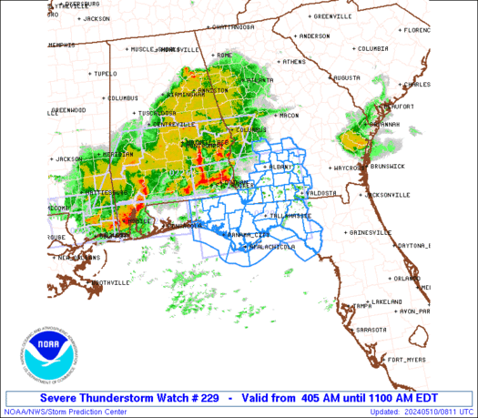
Severe Thunderstorm Watch Number 229
NWS Storm Prediction Center Norman OK
405 AM EDT Fri May 10 2024
The NWS Storm Prediction Center has issued a
* Severe Thunderstorm Watch for portions of
Northern Florida
Southern Georgia
Coastal Waters
* Effective this Friday morning from 405 AM until 1100 AM EDT.
* Primary threats include...
Widespread damaging winds likely with isolated significant gusts
to 80 mph possible
Isolated large hail events to 1.5 inches in diameter possible
A tornado or two possible
SUMMARY...Multiple well-organized squall lines with bowing segments
will quickly spread east-southeastward across the region through the
early morning hours, with damaging winds being the primary hazard.
The severe thunderstorm watch area is approximately along and 75
statute miles north and south of a line from 45 miles northwest of
Panama City FL to 5 miles east of Valdosta GA. For a complete
depiction of the watch see the associated watch outline update
(WOUS64 KWNS WOU9).
PRECAUTIONARY/PREPAREDNESS ACTIONS...
REMEMBER...A Severe Thunderstorm Watch means conditions are
favorable for severe thunderstorms in and close to the watch area.
Persons in these areas should be on the lookout for threatening
weather conditions and listen for later statements and possible
warnings. Severe thunderstorms can and occasionally do produce
tornadoes.
&&
OTHER WATCH INFORMATION...CONTINUE...WW 226...WW 227...WW 228...
AVIATION...A few severe thunderstorms with hail surface and aloft to
1.5 inches. Extreme turbulence and surface wind gusts to 70 knots. A
few cumulonimbi with maximum tops to 550. Mean storm motion vector
29045.
...Guyer

   SEL9

   URGENT - IMMEDIATE BROADCAST REQUESTED
   Severe Thunderstorm Watch Number 229
   NWS Storm Prediction Center Norman OK
   405 AM EDT Fri May 10 2024

   The NWS Storm Prediction Center has issued a

   * Severe Thunderstorm Watch for portions of
     Northern Florida
     Southern Georgia
     Coastal Waters

   * Effective this Friday morning from 405 AM until 1100 AM EDT.

   * Primary threats include...
     Widespread damaging winds likely with isolated significant gusts
       to 80 mph possible
     Isolated large hail events to 1.5 inches in diameter possible
     A tornado or two possible

   SUMMARY...Multiple well-organized squall lines with bowing segments
   will quickly spread east-southeastward across the region through the
   early morning hours, with damaging winds being the primary hazard.

   The severe thunderstorm watch area is approximately along and 75
   statute miles north and south of a line from 45 miles northwest of
   Panama City FL to 5 miles east of Valdosta GA. For a complete
   depiction of the watch see the associated watch outline update
   (WOUS64 KWNS WOU9).

   PRECAUTIONARY/PREPAREDNESS ACTIONS...

   REMEMBER...A Severe Thunderstorm Watch means conditions are
   favorable for severe thunderstorms in and close to the watch area.
   Persons in these areas should be on the lookout for threatening
   weather conditions and listen for later statements and possible
   warnings. Severe thunderstorms can and occasionally do produce
   tornadoes.

   &&

   OTHER WATCH INFORMATION...CONTINUE...WW 226...WW 227...WW 228...

   AVIATION...A few severe thunderstorms with hail surface and aloft to
   1.5 inches. Extreme turbulence and surface wind gusts to 70 knots. A
   few cumulonimbi with maximum tops to 550. Mean storm motion vector
   29045.

   ...Guyer
 Note:
The Aviation Watch (SAW) product is an approximation to the watch area.
The actual watch is depicted by the shaded areas.
Note:
The Aviation Watch (SAW) product is an approximation to the watch area.
The actual watch is depicted by the shaded areas.
   SAW9
   WW 229 SEVERE TSTM FL GA CW 100805Z - 101500Z
   AXIS..75 STATUTE MILES NORTH AND SOUTH OF LINE..
   45NW PFN/PANAMA CITY FL/ - 5E VLD/VALDOSTA GA/
   ..AVIATION COORDS.. 65NM N/S /26ESE CEW - 58SW AMG/
   HAIL SURFACE AND ALOFT..1.5 INCHES. WIND GUSTS..70 KNOTS.
   MAX TOPS TO 550. MEAN STORM MOTION VECTOR 29045.

   LAT...LON 31768622 31878320 29698320 29598622

   THIS IS AN APPROXIMATION TO THE WATCH AREA.  FOR A
   COMPLETE DEPICTION OF THE WATCH SEE WOUS64 KWNS
   FOR WOU9.
Watch 229 Status Report Messages:
STATUS REPORT #2 ON WW 229

VALID 101050Z - 101140Z

SEVERE WEATHER THREAT CONTINUES RIGHT OF A LINE FROM 45 WSW PFN
TO 20 E MAI TO 15 E ABY TO 45 NE ABY.

..BROYLES..05/10/24

ATTN...WFO...TAE...FFC...

&&

STATUS REPORT FOR WS 229

SEVERE WEATHER THREAT CONTINUES FOR THE FOLLOWING AREAS

FLC005-013-029-037-039-045-065-067-073-077-079-123-129-101140-

FL
.    FLORIDA COUNTIES INCLUDED ARE

BAY		     CALHOUN		 DIXIE
FRANKLIN	     GADSDEN		 GULF
JEFFERSON	     LAFAYETTE		 LEON
LIBERTY 	     MADISON		 TAYLOR
WAKULLA
$$


GAC017-019-027-071-075-087-131-155-173-185-205-253-275-277-287-
315-321-101140-

GA
.    GEORGIA COUNTIES INCLUDED ARE

BEN HILL	     BERRIEN		 BROOKS
COLQUITT	     COOK		 DECATUR
GRADY		     IRWIN		 LANIER
LOWNDES 	     MITCHELL		 SEMINOLE
THOMAS		     TIFT		 TURNER
WILCOX		     WORTH
$$


GMZ730-750-752-755-765-101140-

CW

.    ADJACENT COASTAL WATERS INCLUDED ARE

APALACHEE BAY OR COASTAL WATERS FROM KEATON BEACH TO OCHLOCKONEE
RIVER FL OUT TO 20 NM

COASTAL WATERS FROM OKALOOSA-WALTON COUNTY LINE TO MEXICO BEACH
OUT 20 NM

COASTAL WATERS FROM MEXICO BEACH TO APALACHICOLA OUT 20 NM

COASTAL WATERS FROM  OCHLOCKONEE RIVER TO APALACHICOLA FL OUT TO
20 NM

COASTAL WATERS FROM  SUWANNEE RIVER TO KEATON BEACH OUT 20 NM

$$
THE WATCH STATUS MESSAGE IS FOR GUIDANCE PURPOSES ONLY.  PLEASE
REFER TO WATCH COUNTY NOTIFICATION STATEMENTS FOR OFFICIAL
INFORMATION ON COUNTIES...INDEPENDENT CITIES AND MARINE ZONES
CLEARED FROM SEVERE THUNDERSTORM AND TORNADO WATCHES.
$$

STATUS REPORT #1 ON WW 229

VALID 100835Z - 100940Z

THE SEVERE WEATHER THREAT CONTINUES ACROSS THE ENTIRE WATCH AREA.

..BROYLES..05/10/24

ATTN...WFO...TAE...FFC...

&&

STATUS REPORT FOR WS 229

SEVERE WEATHER THREAT CONTINUES FOR THE FOLLOWING AREAS

FLC005-013-029-037-039-045-059-063-065-067-073-077-079-123-129-
131-133-100940-

FL
.    FLORIDA COUNTIES INCLUDED ARE

BAY		     CALHOUN		 DIXIE
FRANKLIN	     GADSDEN		 GULF
HOLMES		     JACKSON		 JEFFERSON
LAFAYETTE	     LEON		 LIBERTY
MADISON 	     TAYLOR		 WAKULLA
WALTON		     WASHINGTON
$$


GAC007-017-019-027-071-075-081-087-095-131-155-173-177-185-201-
205-253-261-275-277-287-315-321-100940-

GA
.    GEORGIA COUNTIES INCLUDED ARE

BAKER		     BEN HILL		 BERRIEN
BROOKS		     COLQUITT		 COOK
CRISP		     DECATUR		 DOUGHERTY
GRADY		     IRWIN		 LANIER
LEE		     LOWNDES		 MILLER
MITCHELL	     SEMINOLE		 SUMTER
THOMAS		     TIFT		 TURNER
WILCOX		     WORTH
$$


GMZ730-750-752-755-765-100940-

CW

.    ADJACENT COASTAL WATERS INCLUDED ARE

APALACHEE BAY OR COASTAL WATERS FROM KEATON BEACH TO OCHLOCKONEE
RIVER FL OUT TO 20 NM

COASTAL WATERS FROM OKALOOSA-WALTON COUNTY LINE TO MEXICO BEACH
OUT 20 NM

COASTAL WATERS FROM MEXICO BEACH TO APALACHICOLA OUT 20 NM

COASTAL WATERS FROM  OCHLOCKONEE RIVER TO APALACHICOLA FL OUT TO
20 NM

COASTAL WATERS FROM  SUWANNEE RIVER TO KEATON BEACH OUT 20 NM

$$
THE WATCH STATUS MESSAGE IS FOR GUIDANCE PURPOSES ONLY.  PLEASE
REFER TO WATCH COUNTY NOTIFICATION STATEMENTS FOR OFFICIAL
INFORMATION ON COUNTIES...INDEPENDENT CITIES AND MARINE ZONES
CLEARED FROM SEVERE THUNDERSTORM AND TORNADO WATCHES.
$$
Note:
Click for Complete Product Text.
Tornadoes
Probability of 2 or more tornadoes
|
Low (20%)
|
Probability of 1 or more strong (EF2-EF5) tornadoes
|
Low (10%)
|
Wind
Probability of 10 or more severe wind events
|
High (80%)
|
Probability of 1 or more wind events > 65 knots
|
Mod (40%)
|
Hail
Probability of 10 or more severe hail events
|
Low (20%)
|
Probability of 1 or more hailstones > 2 inches
|
Low (<5%)
|
Combined Severe Hail/Wind
Probability of 6 or more combined severe hail/wind events
|
High (>95%)
|
For each watch, probabilities for particular events inside the watch
(listed above in each table) are determined by the issuing forecaster.
The "Low" category contains probability values ranging from less than 2%
to 20% (EF2-EF5 tornadoes), less than 5% to 20% (all other probabilities),
"Moderate" from 30% to 60%, and "High" from 70% to greater than 95%.
High values are bolded and lighter in color to provide awareness of
an increased threat for a particular event.


 @NWSSPC


