Mesoscale Discussion 1521
NWS Storm Prediction Center Norman OK
1254 PM CDT Fri Aug 18 2017
Areas affected...Southeast NY...Eastern
PA...NJ...DE...MD...Northeast VA
Concerning...Severe potential...Watch possible
Valid 181754Z - 182000Z
Probability of Watch Issuance...60 percent
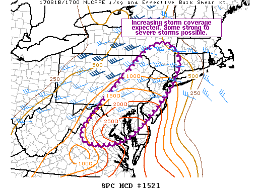
SUMMARY...Thunderstorm coverage is expected to increase over the
next few hours. Some strong to severe storms are anticipated, with
damaging wind gusts as the primary severe threat.
DISCUSSION...Latest surface analysis indicates a broadly confluent
frontal zone extending from the Adirondack mountains southwestward
through eastern PA and western VA. Visible satellite shows extensive
cloud cover across central and eastern NY/PA while the pre-frontal
areas of southeast PA, central MD and central/eastern VA remain
relatively cloud free. Temperatures have warmed into the low 90s in
these cloud free areas, which, in conjunction with a very moist
low-level airmass, supports MLCAPE greater around 2000-3000 J/kg.
Cooler surface temperatures exist farther north with a corresponding
drop in instability. However, better forcing for ascent is expected
farther north as the shortwave trough continues northeastward
through northern New England. Stronger mid-level flow and, as a
result, stronger bulk shear, are also anticipated across northern
portions of the discussion area (i.e. southeast NY, northeast PA,
and northern NJ).
Overall expectation is for storm coverage to gradually increase over
the next few hours as forcing for ascent associated both with the
shortwave trough and approaching cold front interact with the very
unstable airmass across much of the region. Wet microbursts capable
of damaging wind gusts are possible within the strongest updrafts
with some stronger wind gusts also possible along the leading edge
of any convective lines or bowing segments. Additionally, given the
enhanced low to mid-level flow and very moist airmass, a brief
tornado is also possible. Trends across the region will be monitored
for watch issuance.
..Mosier/Goss.. 08/18/2017
...Please see www.spc.noaa.gov for graphic product...
ATTN...WFO...OKX...ALY...PHI...BGM...AKQ...CTP...LWX...
LAT...LON 41157643 42397483 42387377 41527335 40007438 38207660
38357887 41157643
|


 @NWSSPC