|
| Mesoscale Discussion 1522 |
|
< Previous MD Next MD >
|
|
Mesoscale Discussion 1522
NWS Storm Prediction Center Norman OK
0254 PM CDT Fri Aug 18 2017
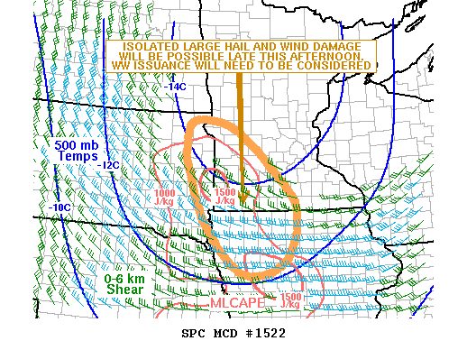
Areas affected...Northeast South Dakota...Southwest
Minnesota...Northwest Iowa
Concerning...Severe potential...Watch possible
Valid 181954Z - 182230Z
Probability of Watch Issuance...40 percent
SUMMARY...A threat for isolated large hail and wind damage should
continue to develop this afternoon from northeast South Dakota
southeastward into southwestern Minnesota. Weather watch issuance
will need to be considered.
DISCUSSION...The latest surface analysis shows a cold front moving
eastward across eastern South Dakota with surface dewpoints just
ahead of the front in the mid 60s F. In response to the low-level
moisture and surface heating, moderate instability has developed
with MLCAPE values estimated in the 1000 to 1500 J/kg range. In
addition, water vapor imagery shows an upper-level trough over the
upper Mississippi Valley with a cold pocket aloft where 500 mb
temperatures are in the -14 to -15 C range. This combined with
strong large-scale ascent associated with the upper-level trough and
increasing instability, will be favorable for an isolated severe
threat this afternoon. Although deep-layer shear is not that strong,
the cold temperatures aloft will be favorable for hail with the
stronger updrafts. As cells continue to move southeastward into
stronger instability and more favorable deep-layer shear, a wind
damage threat may also develop.
..Broyles/Goss.. 08/18/2017
...Please see www.spc.noaa.gov for graphic product...
ATTN...WFO...MPX...DMX...FSD...OAX...ABR...
LAT...LON 45549572 45749715 45089740 44629735 43169672 41919541
42219398 43469354 44439430 45549572
|
|
Top/All Mesoscale Discussions/Forecast Products/Home
|
|


 @NWSSPC