|
| Mesoscale Discussion 539 |
|
< Previous MD Next MD >
|
|
Mesoscale Discussion 0539
NWS Storm Prediction Center Norman OK
0929 PM CDT Mon May 04 2020
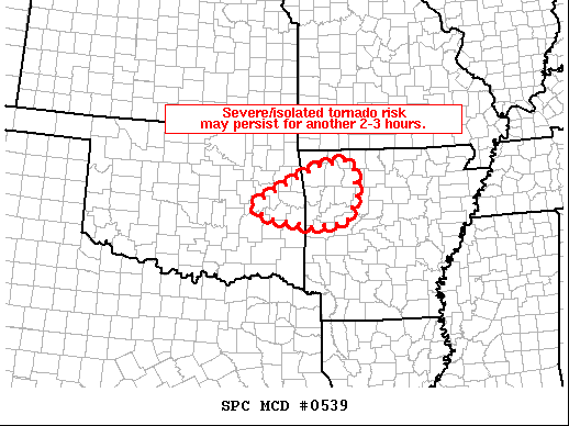
Areas affected...east-central Oklahoma...northwestern Arkansas
Concerning...Tornado Watch 163...
Valid 050229Z - 050330Z
The severe weather threat for Tornado Watch 163 continues.
SUMMARY...Severe/isolated tornado risk continues with a few stronger
cells, and my persist for a short time beyond the scheduled
expiration of WW 163. Local extensions in time/space may be
considered.
DISCUSSION...Recent radar data over the past hour reveals a very
gradual decrease in convective intensity and associated severe risk,
in tandem with the onset of diurnal boundary-layer cooling. A few
stronger cells persist however, particularly a supercell storm
crossing western Sequoyah County Oklahoma, which remains capable of
producing hail in excess of 2" in diameter per MRMS MESH data.
At this time, it appears that local severe risk may persist beyond
05/03Z, though a continuation of the overall, gradual decrease in
convective intensity should continue. Local extensions of the WW
may be considered to extend beyond 03Z for a portion of east-central
OK and adjacent western AR.
..Goss.. 05/05/2020
...Please see www.spc.noaa.gov for graphic product...
ATTN...WFO...LZK...TSA...
LAT...LON 35379575 36179412 36279339 36109322 35549313 35019340
34939430 35139547 35379575
|
|
Top/All Mesoscale Discussions/Forecast Products/Home
|
|


 @NWSSPC