|
| Mesoscale Discussion 574 |
|
< Previous MD Next MD >
|
|
Mesoscale Discussion 0574
NWS Storm Prediction Center Norman OK
0549 PM CDT Tue May 12 2020
Areas affected...Central and eastern Wyoming
Concerning...Severe potential...Watch unlikely
Valid 122249Z - 130045Z
Probability of Watch Issuance...5 percent
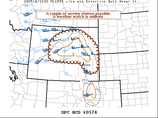
SUMMARY...Isolated severe weather is possible with thunderstorms
developing over portions of central and eastern Wyoming. Limited
instability and the lack of stronger forcing will likely mitigate
the need for a watch.
DISCUSSION...Afternoon water vapor imagery shows lift from a
shortwave trough embedded within 50 to 60 kt of southwesterly flow
overspreading portions of Wyoming. 22z surface analysis shows a 1001
mb low over southwestern Wyoming, drawing a plume of low to middle
40s F dewpoints northward across the eastern 3rd of the state. A few
storms have developed near the Bighorn Mountains and northeastern
Wyoming, near a narrow corridor of 250-500 J/kg MLCAPE and 40-50 kt
of vertical shear. Evolution of theses storms is uncertain given the
weak instability and lack of a stronger forcing mechanism.
Nevertheless, it seems possible that isolated severe weather could
develop from any multi cell or weak supercell structures that are
able to organize before moving east of the narrow instability axis.
The main threats would be isolated severe hail and damaging winds,
but the limited coverage and lack of a greater severe threat
suggests a weather watch is not needed at this time.
..Lyons/Grams.. 05/12/2020
...Please see www.spc.noaa.gov for graphic product...
ATTN...WFO...UNR...CYS...BYZ...RIW...
LAT...LON 43850894 44100866 44360826 44610754 44740600 44640575
44300521 44090483 43790452 43450421 42680415 42200418
41930429 41600441 41700490 41900548 42070554 42440602
42380664 42420751 42490856 42550892 43230904 43850894
|
|
Top/All Mesoscale Discussions/Forecast Products/Home
|
|


 @NWSSPC