|
| Mesoscale Discussion 575 |
|
< Previous MD Next MD >
|
|
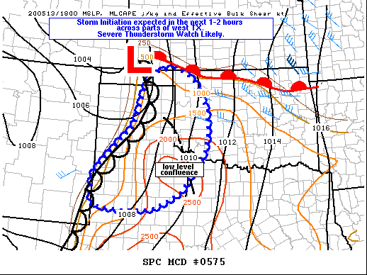
   Mesoscale Discussion 0575
   NWS Storm Prediction Center Norman OK
   0200 PM CDT Wed May 13 2020

   Areas affected...portions of the OK/TX Panhandles...western OK and
   western TX

   Concerning...Severe potential...Severe Thunderstorm Watch likely

   Valid 131900Z - 132030Z

   Probability of Watch Issuance...95 percent

   SUMMARY...Severe thunderstorms are expected within the next couple
   of hours. Damaging gusts and large hail will be the main hazards
   with these storms. A severe thunderstorm watch will be issued soon.

   DISCUSSION...Deepening CU has been noted over the last 30-60 minutes
   near the TX/NM boarder over Cochran to Gaines Counties just ahead of
   the surface dryline. South/southeasterly low level flow south of
   Lubbock southward toward Midland is resulting in strong low level
   convergence along the dryline in this area. Furthermore, strong
   surface heating is resulting in temperatures in the mid to upper
   80s, quickly approaching convective temperatures. 18z regional RAOBs
   indicate there is still some MLCIN, but additional heating and
   sharpening of the dryline will overcome this in the next couple of
   hours.

   Additional CU development has been noted further northeast toward
   CDS where low level stratus has mostly cleared and MLCAPE has
   increased to around 2000 J/kg. Surface analysis also showed a
   confluence zone from the eastern TX Panhandle toward far southwest
   OK/western north TX in this vicinity. This should foster increasing
   low level ascent as a dryline bulge mixes eastward toward the
   eastern TX Panhandle. As a result, there could be multiple areas of
   convective initiation around the same time this afternoon across the
   broader region from the OK/TX panhandle southward through the TX
   South Plains.

   18z RAOBs show very steep lapse rates across the region, but
   overall, effective bulk shear is rather marginal, on the order of
   25-35 kt. Some discrete cells could develop initially, especially
   near the TX/OK border where low level moisture is deeper and
   vertical shear is a bit more favorable. Semi-discrete storms will be
   capable of large hail and damaging gusts. Nevertheless, a transition
   toward clusters/bowing segments is likely to occur within 1-2 hours,
   especially further south where the deeply mixed boundary layer will
   result in strong downdraft potential.

   ..Leitman/Thompson.. 05/13/2020

   ...Please see www.spc.noaa.gov for graphic product...

   ATTN...WFO...OUN...DDC...SJT...LUB...AMA...MAF...

   LAT...LON   33500308 33910283 34610216 35200155 36010129 36550116
               36880087 36990054 37040002 36949967 36769936 36639925
               36299898 35729877 35039868 34369884 33879917 33109976
               32600067 32580083 32540182 32570269 32690302 32940309
               33500308
|
|
Top/All Mesoscale Discussions/Forecast Products/Home
|
|


 @NWSSPC