|
| Mesoscale Discussion 1037 |
|
< Previous MD Next MD >
|
|
Mesoscale Discussion 1037
NWS Storm Prediction Center Norman OK
0522 PM CDT Sun Jun 20 2021
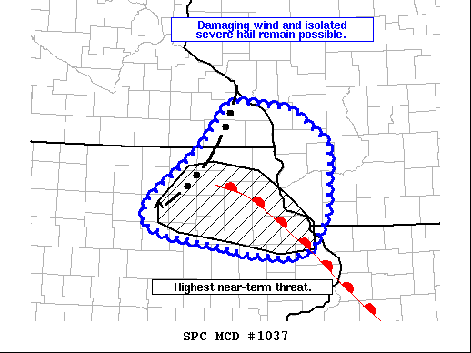
Areas affected...Far southeast Minnesota...northeast Iowa...and far
western Wisconsin
Concerning...Severe Thunderstorm Watch 293...
Valid 202222Z - 210015Z
The severe weather threat for Severe Thunderstorm Watch 293
continues.
SUMMARY...The threat for damaging winds and severe hail will
continue for the next 1-2 hours for WW 293. The greatest near-term
risk will likely reside across northeast Iowa.
DISCUSSION...A convective line continues to push eastward across
southeast MN and northern/northeast IA. So far, wind reports have
generally been sub-severe, but radar imagery from KMPX and KARX
suggest pockets of damaging wind remain possible as cold pool
organization continues. 0-3 km bulk shear in this region remains
nearly orthogonal to the line with magnitudes between 20-30 knots,
further supporting the idea of at least an isolated damaging wind
threat.
Although the line's eastward motion has phased well with the
eastward progression of the surface low and viable warm sector,
remnant stable outflow to the east across southern WI/northern IL
may hinder storm intensity to some degree - especially north of an
effective warm frontal boundary noted in recent surface obs. South
of this boundary, the higher theta-e air mass should provide enough
better instability to maintain storm intensity and the wind/hail
threat into the evening hours.
..Moore.. 06/20/2021
...Please see www.spc.noaa.gov for graphic product...
ATTN...WFO...MKX...DVN...ARX...DMX...
LAT...LON 43499249 44089199 43969092 43539028 42689033 42219062
42139105 42199173 42289223 42409303 42549345 42829337
43499249
|
|
Top/All Mesoscale Discussions/Forecast Products/Home
|
|


 @NWSSPC