Mesoscale Discussion 0582
NWS Storm Prediction Center Norman OK
0223 PM CDT Fri Apr 29 2022
Areas affected...east-central Kansas into north-central Oklahoma
Concerning...Severe potential...Tornado Watch likely
Valid 291923Z - 292200Z
Probability of Watch Issuance...80 percent
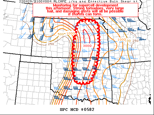
SUMMARY...Monitoring for supercell development along the dryline
this afternoon. Strong tornadoes, very large hail, and damaging
gusts will all be possible with this activity. A Tornado Watch will
likely be needed for parts of the area.
DISCUSSION...Water vapor imagery indicates a strong midlevel speed
maximum approaching KS/OK, where modest midlevel height falls are
occurring. As this speed maximum continues overspreading the area, a
NNE-SSW oriented dryline will sharpen across east-central KS into
north-central OK. The strengthening dryline circulation, combined
with south-southwesterly low-level flow oriented largely parallel to
the dryline should allow for isolated convective initiation between
20Z-23Z. Surface dewpoints in the middle/upper 60s F beneath very
steep midlevel lapse rates will support a strongly unstable airmass
(MLCAPE nearing 3000 J/kg), while effective bulk shear increases to
around 40 knots. These factors, coupled with strongly veering wind
profiles in the boundary-layer (200-300 m2/s2 effective SRH) would
certainly favor supercells capable of strong tornadoes, very large
hail, and damaging gusts. There is still some uncertainty in the
overall coverage and location of the severe threat, though trends
will continue to be monitored for Tornado Watch issuance for parts
of this area.
..Weinman/Hart.. 04/29/2022
...Please see www.spc.noaa.gov for graphic product...
ATTN...WFO...TSA...TOP...ICT...OUN...
LAT...LON 37189793 37609790 38129789 38719776 39699753 39879698
39849610 39589562 38019557 37269571 36679586 35969606
35279640 35149662 35129726 35259777 36139789 36559796
36919796 37189793
|


 @NWSSPC