|
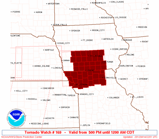
Initial List of Counties in SPC Tornado Watch 169 (WOU)
|
Back to Watch 169
|
 |
   WOUS64 KWNS 142156
   WOU9

   BULLETIN - IMMEDIATE BROADCAST REQUESTED
   TORNADO WATCH OUTLINE UPDATE FOR WT 169
   NWS STORM PREDICTION CENTER NORMAN OK
   500 PM CDT SAT APR 14 2012

   TORNADO WATCH 169 IS IN EFFECT UNTIL 1200 AM CDT FOR THE
    FOLLOWING LOCATIONS

   IAC001-003-007-009-029-039-049-051-053-077-099-117-121-123-125-
   135-153-157-159-173-175-179-181-185-150500-
   /O.NEW.KWNS.TO.A.0169.120414T2200Z-120415T0500Z/

   IA
   .    IOWA COUNTIES INCLUDED ARE

   ADAIR                ADAMS               APPANOOSE
   AUDUBON              CASS                CLARKE
   DALLAS               DAVIS               DECATUR
   GUTHRIE              JASPER              LUCAS
   MADISON              MAHASKA             MARION
   MONROE               POLK                POWESHIEK
   RINGGOLD             TAYLOR              UNION
   WAPELLO              WARREN              WAYNE


   KSC043-150500-
   /O.NEW.KWNS.TO.A.0169.120414T2200Z-120415T0500Z/

   KS
   .    KANSAS COUNTIES INCLUDED ARE

   DONIPHAN


   MOC001-003-005-021-025-049-061-063-075-079-081-087-115-117-121-
   129-147-171-197-211-227-150500-
   /O.NEW.KWNS.TO.A.0169.120414T2200Z-120415T0500Z/

   MO
   .    MISSOURI COUNTIES INCLUDED ARE

   ADAIR                ANDREW              ATCHISON
   BUCHANAN             CALDWELL            CLINTON
   DAVIESS              DEKALB              GENTRY
   GRUNDY               HARRISON            HOLT
   LINN                 LIVINGSTON          MACON
   MERCER               NODAWAY             PUTNAM
   SCHUYLER             SULLIVAN            WORTH


   ATTN...WFO...DMX...EAX...
|
| Aviation Watch (SAW) for WW169 |
|---|
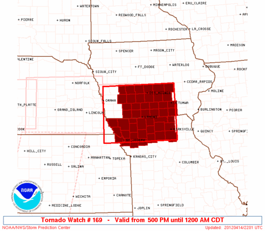 |
| Note:
The Aviation Watch (SAW) product is an approximation to the watch area.
The actual watch is depicted by the shaded areas. |
   SAW9
   WW 169 TORNADO IA KS MO 142200Z - 150500Z
   AXIS..75 STATUTE MILES NORTH AND SOUTH OF LINE..
   25W SDA/SHENANDOAH IA/ - 25SSE OTM/OTTUMWA IA/
   ..AVIATION COORDS.. 65NM N/S /26SSW OVR - 40NNE IRK/
   HAIL SURFACE AND ALOFT..2 INCHES. WIND GUSTS..60 KNOTS.
   MAX TOPS TO 500. MEAN STORM MOTION VECTOR 24035.

   LAT...LON 41839590 41849226 39689226 39659590

   THIS IS AN APPROXIMATION TO THE WATCH AREA.  FOR A
   COMPLETE DEPICTION OF THE WATCH SEE WOUS64 KWNS
   FOR WOU9.
|
|


 @NWSSPC
