 Note:
The expiration time in the watch graphic is amended if the watch is
replaced, cancelled or extended.
Note:
Note:
The expiration time in the watch graphic is amended if the watch is
replaced, cancelled or extended.
Note: Click for
Watch Status Reports.
SEL9
URGENT - IMMEDIATE BROADCAST REQUESTED
Severe Thunderstorm Watch Number 199
NWS Storm Prediction Center Norman OK
810 PM CDT Sun May 23 2021
The NWS Storm Prediction Center has issued a
* Severe Thunderstorm Watch for portions of
Northwest Kansas
Central Nebraska
South Central South Dakota
* Effective this Sunday night and Monday morning from 810 PM
until 100 AM CDT.
* Primary threats include...
Scattered large hail likely with isolated very large hail events
to 2 inches in diameter possible
Scattered damaging wind gusts to 70 mph likely
A tornado or two possible
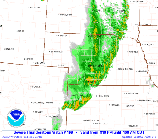
SUMMARY...A line of intense thunderstorms will track northeastward
across the watch area through the evening hours, posing a risk of
locally damaging wind gusts and hail.
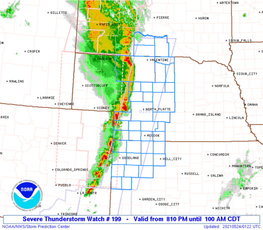
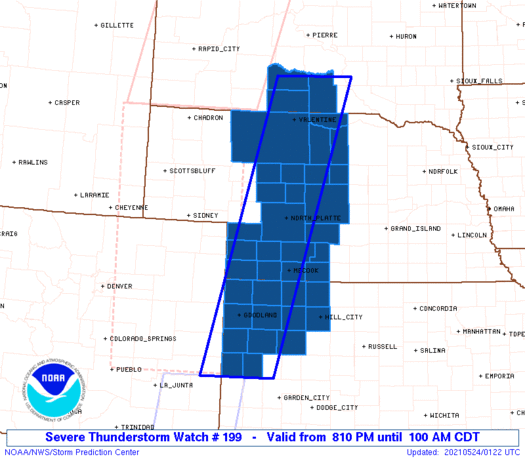
The severe thunderstorm watch area is approximately along and 45
statute miles east and west of a line from 60 miles north northeast
of Valentine NE to 75 miles south of Goodland KS. For a complete
depiction of the watch see the associated watch outline update
(WOUS64 KWNS WOU9).
PRECAUTIONARY/PREPAREDNESS ACTIONS...
REMEMBER...A Severe Thunderstorm Watch means conditions are
favorable for severe thunderstorms in and close to the watch area.
Persons in these areas should be on the lookout for threatening
weather conditions and listen for later statements and possible
warnings. Severe thunderstorms can and occasionally do produce
tornadoes.
&&
OTHER WATCH INFORMATION...CONTINUE...WW 196...WW 197...WW 198...
AVIATION...A few severe thunderstorms with hail surface and aloft to
2 inches. Extreme turbulence and surface wind gusts to 60 knots. A
few cumulonimbi with maximum tops to 500. Mean storm motion vector
24035.
...Hart
   SEL9

   URGENT - IMMEDIATE BROADCAST REQUESTED
   Severe Thunderstorm Watch Number 199
   NWS Storm Prediction Center Norman OK
   810 PM CDT Sun May 23 2021

   The NWS Storm Prediction Center has issued a

   * Severe Thunderstorm Watch for portions of
     Northwest Kansas
     Central Nebraska
     South Central South Dakota

   * Effective this Sunday night and Monday morning from 810 PM
     until 100 AM CDT.

   * Primary threats include...
     Scattered large hail likely with isolated very large hail events
       to 2 inches in diameter possible
     Scattered damaging wind gusts to 70 mph likely
     A tornado or two possible

   SUMMARY...A line of intense thunderstorms will track northeastward
   across the watch area through the evening hours, posing a risk of
   locally damaging wind gusts and hail.

   The severe thunderstorm watch area is approximately along and 45
   statute miles east and west of a line from 60 miles north northeast
   of Valentine NE to 75 miles south of Goodland KS. For a complete
   depiction of the watch see the associated watch outline update
   (WOUS64 KWNS WOU9).

   PRECAUTIONARY/PREPAREDNESS ACTIONS...

   REMEMBER...A Severe Thunderstorm Watch means conditions are
   favorable for severe thunderstorms in and close to the watch area.
   Persons in these areas should be on the lookout for threatening
   weather conditions and listen for later statements and possible
   warnings. Severe thunderstorms can and occasionally do produce
   tornadoes.

   &&

   OTHER WATCH INFORMATION...CONTINUE...WW 196...WW 197...WW 198...

   AVIATION...A few severe thunderstorms with hail surface and aloft to
   2 inches. Extreme turbulence and surface wind gusts to 60 knots. A
   few cumulonimbi with maximum tops to 500. Mean storm motion vector
   24035.

   ...Hart
 Note:
The Aviation Watch (SAW) product is an approximation to the watch area.
The actual watch is depicted by the shaded areas.
Note:
The Aviation Watch (SAW) product is an approximation to the watch area.
The actual watch is depicted by the shaded areas.
   SAW9
   WW 199 SEVERE TSTM KS NE SD 240110Z - 240600Z
   AXIS..45 STATUTE MILES EAST AND WEST OF LINE..
   60NNE VTN/VALENTINE NE/ - 75S GLD/GOODLAND KS/
   ..AVIATION COORDS.. 40NM E/W /45S PIR - 47E LAA/
   HAIL SURFACE AND ALOFT..2 INCHES. WIND GUSTS..60 KNOTS.
   MAX TOPS TO 500. MEAN STORM MOTION VECTOR 24035.

   LAT...LON 43659919 38270087 38270253 43650099

   THIS IS AN APPROXIMATION TO THE WATCH AREA.  FOR A
   COMPLETE DEPICTION OF THE WATCH SEE WOUS64 KWNS
   FOR WOU9.
Watch 199 Status Report Messages:
STATUS REPORT #2 ON WW 199

VALID 240435Z - 240540Z

SEVERE WEATHER THREAT CONTINUES RIGHT OF A LINE FROM 30 NNE ITR
TO 15 NW MCK TO 40 SE LBF.

..SPC..05/24/21

ATTN...WFO...GLD...LBF...GID...UNR...

&&

STATUS REPORT FOR WS 199

SEVERE WEATHER THREAT CONTINUES FOR THE FOLLOWING AREAS

KSC023-039-063-065-071-109-137-153-179-181-193-199-203-240540-

KS
.    KANSAS COUNTIES INCLUDED ARE

CHEYENNE	     DECATUR		 GOVE
GRAHAM		     GREELEY		 LOGAN
NORTON		     RAWLINS		 SHERIDAN
SHERMAN 	     THOMAS		 WALLACE
WICHITA
$$


NEC041-047-063-065-073-087-115-145-240540-

NE
.    NEBRASKA COUNTIES INCLUDED ARE

CUSTER		     DAWSON		 FRONTIER
FURNAS		     GOSPER		 HITCHCOCK
LOUP		     RED WILLOW
$$


THE WATCH STATUS MESSAGE IS FOR GUIDANCE PURPOSES ONLY.  PLEASE
REFER TO WATCH COUNTY NOTIFICATION STATEMENTS FOR OFFICIAL
INFORMATION ON COUNTIES...INDEPENDENT CITIES AND MARINE ZONES
CLEARED FROM SEVERE THUNDERSTORM AND TORNADO WATCHES.
$$

STATUS REPORT #1 ON WW 199

VALID 240225Z - 240340Z

THE SEVERE WEATHER THREAT CONTINUES ACROSS THE ENTIRE WATCH AREA.

..WENDT..05/24/21

ATTN...WFO...GLD...LBF...GID...UNR...

&&

STATUS REPORT FOR WS 199

SEVERE WEATHER THREAT CONTINUES FOR THE FOLLOWING AREAS

KSC023-039-063-065-071-109-137-153-179-181-193-199-203-240340-

KS
.    KANSAS COUNTIES INCLUDED ARE

CHEYENNE	     DECATUR		 GOVE
GRAHAM		     GREELEY		 LOGAN
NORTON		     RAWLINS		 SHERIDAN
SHERMAN 	     THOMAS		 WALLACE
WICHITA
$$


NEC009-017-029-031-041-047-057-063-065-073-085-087-091-103-111-
113-115-117-135-145-149-171-240340-

NE
.    NEBRASKA COUNTIES INCLUDED ARE

BLAINE		     BROWN		 CHASE
CHERRY		     CUSTER		 DAWSON
DUNDY		     FRONTIER		 FURNAS
GOSPER		     HAYES		 HITCHCOCK
HOOKER		     KEYA PAHA		 LINCOLN
LOGAN		     LOUP		 MCPHERSON
PERKINS 	     RED WILLOW 	 ROCK
THOMAS
$$


SDC095-121-123-240340-

SD
.    SOUTH DAKOTA COUNTIES INCLUDED ARE

MELLETTE	     TODD		 TRIPP
$$


THE WATCH STATUS MESSAGE IS FOR GUIDANCE PURPOSES ONLY.  PLEASE
REFER TO WATCH COUNTY NOTIFICATION STATEMENTS FOR OFFICIAL
INFORMATION ON COUNTIES...INDEPENDENT CITIES AND MARINE ZONES
CLEARED FROM SEVERE THUNDERSTORM AND TORNADO WATCHES.
$$
Note:
Click for Complete Product Text.
Tornadoes
Probability of 2 or more tornadoes
|
Low (20%)
|
Probability of 1 or more strong (EF2-EF5) tornadoes
|
Low (5%)
|
Wind
Probability of 10 or more severe wind events
|
High (70%)
|
Probability of 1 or more wind events > 65 knots
|
Low (20%)
|
Hail
Probability of 10 or more severe hail events
|
Mod (60%)
|
Probability of 1 or more hailstones > 2 inches
|
Mod (30%)
|
Combined Severe Hail/Wind
Probability of 6 or more combined severe hail/wind events
|
High (>95%)
|
For each watch, probabilities for particular events inside the watch
(listed above in each table) are determined by the issuing forecaster.
The "Low" category contains probability values ranging from less than 2%
to 20% (EF2-EF5 tornadoes), less than 5% to 20% (all other probabilities),
"Moderate" from 30% to 60%, and "High" from 70% to greater than 95%.
High values are bolded and lighter in color to provide awareness of
an increased threat for a particular event.


 @NWSSPC


