 Note:
The expiration time in the watch graphic is amended if the watch is
replaced, cancelled or extended.
Note:
Note:
The expiration time in the watch graphic is amended if the watch is
replaced, cancelled or extended.
Note: Click for
Watch Status Reports.
SEL3
URGENT - IMMEDIATE BROADCAST REQUESTED
Tornado Watch Number 213
NWS Storm Prediction Center Norman OK
345 PM CDT Thu May 11 2023
The NWS Storm Prediction Center has issued a
* Tornado Watch for portions of
Southern and Central Oklahoma
North Texas
* Effective this Thursday afternoon and evening from 345 PM until
1100 PM CDT.
* Primary threats include...
A few tornadoes and a couple intense tornadoes possible
Scattered large hail likely with isolated very large hail events
to 2.5 inches in diameter possible
Scattered damaging wind gusts to 70 mph possible
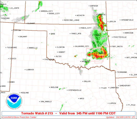
SUMMARY...Storms are expected to quickly develop and intensify
through late afternoon, initially across southern Oklahoma and far
north Texas in vicinity of a remnant boundary. Additional
development will likely occur east-northeastward into central
Oklahoma by early evening as the air mass continues to quickly
moisten and destabilize. Supercells capable of very large hail and
tornadoes can be expected through at least mid-evening as storms
spread toward/east of the I-35 corridor.
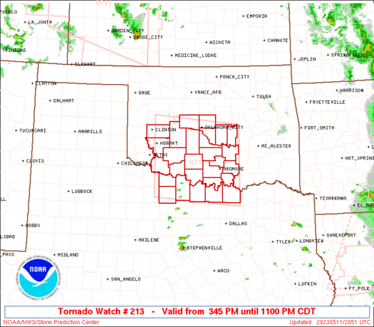
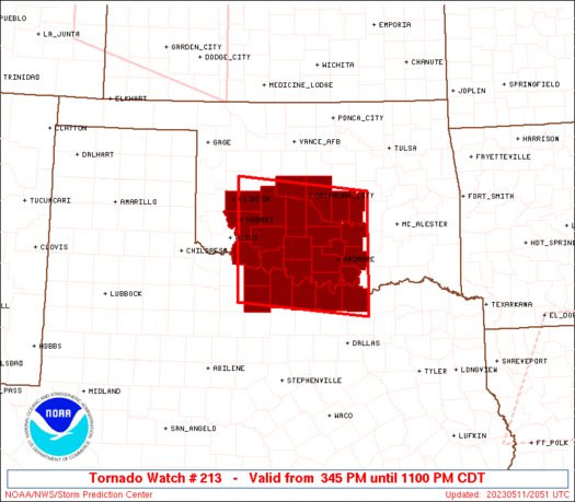
The tornado watch area is approximately along and 75 statute miles
north and south of a line from 40 miles west of Fort Sill OK to 30
miles north of Durant OK. For a complete depiction of the watch see
the associated watch outline update (WOUS64 KWNS WOU3).
PRECAUTIONARY/PREPAREDNESS ACTIONS...
REMEMBER...A Tornado Watch means conditions are favorable for
tornadoes and severe thunderstorms in and close to the watch
area. Persons in these areas should be on the lookout for
threatening weather conditions and listen for later statements
and possible warnings.
&&
OTHER WATCH INFORMATION...CONTINUE...WW 210...WW 211...WW 212...
AVIATION...Tornadoes and a few severe thunderstorms with hail
surface and aloft to 2.5 inches. Extreme turbulence and surface wind
gusts to 60 knots. A few cumulonimbi with maximum tops to 500. Mean
storm motion vector 22025.
...Guyer
   SEL3

   URGENT - IMMEDIATE BROADCAST REQUESTED
   Tornado Watch Number 213
   NWS Storm Prediction Center Norman OK
   345 PM CDT Thu May 11 2023

   The NWS Storm Prediction Center has issued a

   * Tornado Watch for portions of
     Southern and Central Oklahoma
     North Texas

   * Effective this Thursday afternoon and evening from 345 PM until
     1100 PM CDT.

   * Primary threats include...
     A few tornadoes and a couple intense tornadoes possible
     Scattered large hail likely with isolated very large hail events
       to 2.5 inches in diameter possible
     Scattered damaging wind gusts to 70 mph possible

   SUMMARY...Storms are expected to quickly develop and intensify
   through late afternoon, initially across southern Oklahoma and far
   north Texas in vicinity of a remnant boundary. Additional
   development will likely occur east-northeastward into central
   Oklahoma by early evening as the air mass continues to quickly
   moisten and destabilize. Supercells capable of very large hail and
   tornadoes can be expected through at least mid-evening as storms
   spread toward/east of the I-35 corridor.

   The tornado watch area is approximately along and 75 statute miles
   north and south of a line from 40 miles west of Fort Sill OK to 30
   miles north of Durant OK. For a complete depiction of the watch see
   the associated watch outline update (WOUS64 KWNS WOU3).

   PRECAUTIONARY/PREPAREDNESS ACTIONS...

   REMEMBER...A Tornado Watch means conditions are favorable for
   tornadoes and severe thunderstorms in and close to the watch
   area. Persons in these areas should be on the lookout for
   threatening weather conditions and listen for later statements
   and possible warnings.

   &&

   OTHER WATCH INFORMATION...CONTINUE...WW 210...WW 211...WW 212...

   AVIATION...Tornadoes and a few severe thunderstorms with hail
   surface and aloft to 2.5 inches. Extreme turbulence and surface wind
   gusts to 60 knots. A few cumulonimbi with maximum tops to 500. Mean
   storm motion vector 22025.

   ...Guyer
 Note:
The Aviation Watch (SAW) product is an approximation to the watch area.
The actual watch is depicted by the shaded areas.
Note:
The Aviation Watch (SAW) product is an approximation to the watch area.
The actual watch is depicted by the shaded areas.
   SAW3
   WW 213 TORNADO OK TX 112045Z - 120400Z
   AXIS..75 STATUTE MILES NORTH AND SOUTH OF LINE..
   40W FSI/FORT SILL OK/ - 30N DUA/DURANT OK/
   ..AVIATION COORDS.. 65NM N/S /47NNW SPS - 40ENE ADM/
   HAIL SURFACE AND ALOFT..2.5 INCHES. WIND GUSTS..60 KNOTS.
   MAX TOPS TO 500. MEAN STORM MOTION VECTOR 22025.

   LAT...LON 35739910 35479640 33309640 33569910

   THIS IS AN APPROXIMATION TO THE WATCH AREA.  FOR A
   COMPLETE DEPICTION OF THE WATCH SEE WOUS64 KWNS
   FOR WOU3.
Watch 213 Status Report Messages:
STATUS REPORT #6 ON WW 213

VALID 120340Z - 120440Z

SEVERE WEATHER THREAT CONTINUES RIGHT OF A LINE FROM 20 N DUA TO
15 NW ADM TO 25 SE OKC TO 20 SW CQB.

FOR ADDITIONAL INFORMATION SEE MESOSCALE DISCUSSION 770

..SMITH..05/12/23

ATTN...WFO...OUN...FWD...

&&

STATUS REPORT FOR WT 213

SEVERE WEATHER THREAT CONTINUES FOR THE FOLLOWING AREAS

OKC005-027-029-063-069-081-099-119-123-125-133-120440-

OK
.    OKLAHOMA COUNTIES INCLUDED ARE

ATOKA		     CLEVELAND		 COAL
HUGHES		     JOHNSTON		 LINCOLN
MURRAY		     PAYNE		 PONTOTOC
POTTAWATOMIE	     SEMINOLE
$$


THE WATCH STATUS MESSAGE IS FOR GUIDANCE PURPOSES ONLY.  PLEASE
REFER TO WATCH COUNTY NOTIFICATION STATEMENTS FOR OFFICIAL
INFORMATION ON COUNTIES...INDEPENDENT CITIES AND MARINE ZONES
CLEARED FROM SEVERE THUNDERSTORM AND TORNADO WATCHES.
$$

STATUS REPORT #5 ON WW 213

VALID 120140Z - 120240Z

SEVERE WEATHER THREAT CONTINUES RIGHT OF A LINE FROM 40 NNW MWL
TO 35 ESE SPS TO 10 SW END.

..WEINMAN..05/12/23

ATTN...WFO...OUN...FWD...

&&

STATUS REPORT FOR WT 213

SEVERE WEATHER THREAT CONTINUES FOR THE FOLLOWING AREAS

OKC017-019-027-047-049-051-067-069-073-081-083-085-087-095-099-
103-109-119-123-125-133-137-120240-

OK
.    OKLAHOMA COUNTIES INCLUDED ARE

CANADIAN	     CARTER		 CLEVELAND
GARFIELD	     GARVIN		 GRADY
JEFFERSON	     JOHNSTON		 KINGFISHER
LINCOLN 	     LOGAN		 LOVE
MCCLAIN 	     MARSHALL		 MURRAY
NOBLE		     OKLAHOMA		 PAYNE
PONTOTOC	     POTTAWATOMIE	 SEMINOLE
STEPHENS
$$


TXC097-181-237-337-497-120240-

TX
.    TEXAS COUNTIES INCLUDED ARE

COOKE		     GRAYSON		 JACK
MONTAGUE	     WISE
$$


THE WATCH STATUS MESSAGE IS FOR GUIDANCE PURPOSES ONLY.  PLEASE
REFER TO WATCH COUNTY NOTIFICATION STATEMENTS FOR OFFICIAL
INFORMATION ON COUNTIES...INDEPENDENT CITIES AND MARINE ZONES
CLEARED FROM SEVERE THUNDERSTORM AND TORNADO WATCHES.
$$

STATUS REPORT #4 ON WW 213

VALID 120030Z - 120140Z

SEVERE WEATHER THREAT CONTINUES RIGHT OF A LINE FROM 40 SSE SPS
TO 35 ESE SPS TO 35 SSW END.

FOR ADDITIONAL INFORMATION SEE MESOSCALE DISCUSSION 768

..THORNTON..05/12/23

ATTN...WFO...OUN...FWD...

&&

STATUS REPORT FOR WT 213

SEVERE WEATHER THREAT CONTINUES FOR THE FOLLOWING AREAS

OKC017-019-027-047-049-051-067-069-073-081-083-085-087-095-099-
103-109-119-123-125-133-137-120140-

OK
.    OKLAHOMA COUNTIES INCLUDED ARE

CANADIAN	     CARTER		 CLEVELAND
GARFIELD	     GARVIN		 GRADY
JEFFERSON	     JOHNSTON		 KINGFISHER
LINCOLN 	     LOGAN		 LOVE
MCCLAIN 	     MARSHALL		 MURRAY
NOBLE		     OKLAHOMA		 PAYNE
PONTOTOC	     POTTAWATOMIE	 SEMINOLE
STEPHENS
$$


TXC097-181-237-337-497-120140-

TX
.    TEXAS COUNTIES INCLUDED ARE

COOKE		     GRAYSON		 JACK
MONTAGUE	     WISE
$$


THE WATCH STATUS MESSAGE IS FOR GUIDANCE PURPOSES ONLY.  PLEASE
REFER TO WATCH COUNTY NOTIFICATION STATEMENTS FOR OFFICIAL
INFORMATION ON COUNTIES...INDEPENDENT CITIES AND MARINE ZONES
CLEARED FROM SEVERE THUNDERSTORM AND TORNADO WATCHES.
$$

STATUS REPORT #3 ON WW 213

VALID 112345Z - 120040Z

SEVERE WEATHER THREAT CONTINUES RIGHT OF A LINE FROM 45 NNW MWL
TO 20 SW FSI TO 45 NE CSM.

FOR ADDITIONAL INFORMATION SEE MESOSCALE DISCUSSION 767

..THORNTON..05/11/23

ATTN...WFO...OUN...FWD...

&&

STATUS REPORT FOR WT 213

SEVERE WEATHER THREAT CONTINUES FOR THE FOLLOWING AREAS

OKC015-017-019-027-031-033-047-049-051-067-069-073-081-083-085-
087-095-099-103-109-119-123-125-133-137-120040-

OK
.    OKLAHOMA COUNTIES INCLUDED ARE

CADDO		     CANADIAN		 CARTER
CLEVELAND	     COMANCHE		 COTTON
GARFIELD	     GARVIN		 GRADY
JEFFERSON	     JOHNSTON		 KINGFISHER
LINCOLN 	     LOGAN		 LOVE
MCCLAIN 	     MARSHALL		 MURRAY
NOBLE		     OKLAHOMA		 PAYNE
PONTOTOC	     POTTAWATOMIE	 SEMINOLE
STEPHENS
$$


TXC077-097-181-337-120040-

TX
.    TEXAS COUNTIES INCLUDED ARE

CLAY		     COOKE		 GRAYSON
MONTAGUE
$$


THE WATCH STATUS MESSAGE IS FOR GUIDANCE PURPOSES ONLY.  PLEASE
REFER TO WATCH COUNTY NOTIFICATION STATEMENTS FOR OFFICIAL
INFORMATION ON COUNTIES...INDEPENDENT CITIES AND MARINE ZONES
CLEARED FROM SEVERE THUNDERSTORM AND TORNADO WATCHES.
$$

STATUS REPORT #2 ON WW 213

VALID 112225Z - 112340Z

THE SEVERE WEATHER THREAT CONTINUES ACROSS THE ENTIRE WATCH AREA.

..THORNTON..05/11/23

ATTN...WFO...OUN...FWD...

&&

STATUS REPORT FOR WT 213

SEVERE WEATHER THREAT CONTINUES FOR THE FOLLOWING AREAS

OKC015-017-019-027-031-033-049-051-067-069-075-085-087-095-099-
109-123-125-133-137-141-149-112340-

OK
.    OKLAHOMA COUNTIES INCLUDED ARE

CADDO		     CANADIAN		 CARTER
CLEVELAND	     COMANCHE		 COTTON
GARVIN		     GRADY		 JEFFERSON
JOHNSTON	     KIOWA		 LOVE
MCCLAIN 	     MARSHALL		 MURRAY
OKLAHOMA	     PONTOTOC		 POTTAWATOMIE
SEMINOLE	     STEPHENS		 TILLMAN
WASHITA
$$


TXC009-077-097-181-337-485-112340-

TX
.    TEXAS COUNTIES INCLUDED ARE

ARCHER		     CLAY		 COOKE
GRAYSON 	     MONTAGUE		 WICHITA
$$


THE WATCH STATUS MESSAGE IS FOR GUIDANCE PURPOSES ONLY.  PLEASE
REFER TO WATCH COUNTY NOTIFICATION STATEMENTS FOR OFFICIAL
INFORMATION ON COUNTIES...INDEPENDENT CITIES AND MARINE ZONES
CLEARED FROM SEVERE THUNDERSTORM AND TORNADO WATCHES.
$$

STATUS REPORT #1 ON WW 213

VALID 112130Z - 112240Z

THE SEVERE WEATHER THREAT CONTINUES ACROSS THE ENTIRE WATCH AREA.

..THORNTON..05/11/23

ATTN...WFO...OUN...FWD...

&&

STATUS REPORT FOR WT 213

SEVERE WEATHER THREAT CONTINUES FOR THE FOLLOWING AREAS

OKC015-017-019-027-031-033-049-051-067-069-075-085-087-095-099-
109-123-125-133-137-141-149-112240-

OK
.    OKLAHOMA COUNTIES INCLUDED ARE

CADDO		     CANADIAN		 CARTER
CLEVELAND	     COMANCHE		 COTTON
GARVIN		     GRADY		 JEFFERSON
JOHNSTON	     KIOWA		 LOVE
MCCLAIN 	     MARSHALL		 MURRAY
OKLAHOMA	     PONTOTOC		 POTTAWATOMIE
SEMINOLE	     STEPHENS		 TILLMAN
WASHITA
$$


TXC009-077-097-181-337-485-112240-

TX
.    TEXAS COUNTIES INCLUDED ARE

ARCHER		     CLAY		 COOKE
GRAYSON 	     MONTAGUE		 WICHITA
$$


THE WATCH STATUS MESSAGE IS FOR GUIDANCE PURPOSES ONLY.  PLEASE
REFER TO WATCH COUNTY NOTIFICATION STATEMENTS FOR OFFICIAL
INFORMATION ON COUNTIES...INDEPENDENT CITIES AND MARINE ZONES
CLEARED FROM SEVERE THUNDERSTORM AND TORNADO WATCHES.
$$
Note:
Click for Complete Product Text.
Tornadoes
Probability of 2 or more tornadoes
|
Mod (50%)
|
Probability of 1 or more strong (EF2-EF5) tornadoes
|
Mod (40%)
|
Wind
Probability of 10 or more severe wind events
|
Mod (40%)
|
Probability of 1 or more wind events > 65 knots
|
Low (20%)
|
Hail
Probability of 10 or more severe hail events
|
High (70%)
|
Probability of 1 or more hailstones > 2 inches
|
Mod (50%)
|
Combined Severe Hail/Wind
Probability of 6 or more combined severe hail/wind events
|
High (90%)
|
For each watch, probabilities for particular events inside the watch
(listed above in each table) are determined by the issuing forecaster.
The "Low" category contains probability values ranging from less than 2%
to 20% (EF2-EF5 tornadoes), less than 5% to 20% (all other probabilities),
"Moderate" from 30% to 60%, and "High" from 70% to greater than 95%.
High values are bolded and lighter in color to provide awareness of
an increased threat for a particular event.


 @NWSSPC


