 Note:
The expiration time in the watch graphic is amended if the watch is
replaced, cancelled or extended.
Note:
Note:
The expiration time in the watch graphic is amended if the watch is
replaced, cancelled or extended.
Note: Click for
Watch Status Reports.
SEL2
URGENT - IMMEDIATE BROADCAST REQUESTED
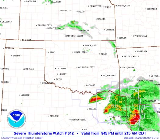
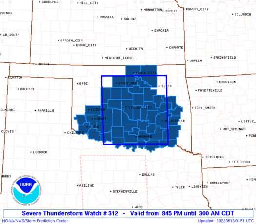
Severe Thunderstorm Watch Number 312
NWS Storm Prediction Center Norman OK
845 PM CDT Thu Jun 15 2023
The NWS Storm Prediction Center has issued a
* Severe Thunderstorm Watch for portions of
Oklahoma
* Effective this Thursday night and Friday morning from 845 PM
until 300 AM CDT.
* Primary threats include...
Scattered damaging winds likely with isolated significant gusts
to 75 mph possible
Scattered large hail and isolated very large hail events to 2
inches in diameter possible
A tornado or two possible
SUMMARY...Multiple convective complexes will spread east tonight
with large hail threat in semi-discrete storms and severe wind gusts
in linear clusters.
The severe thunderstorm watch area is approximately along and 85
statute miles east and west of a line from 50 miles east northeast
of Enid OK to 20 miles south of Ardmore OK. For a complete depiction
of the watch see the associated watch outline update (WOUS64 KWNS
WOU2).
PRECAUTIONARY/PREPAREDNESS ACTIONS...
REMEMBER...A Severe Thunderstorm Watch means conditions are
favorable for severe thunderstorms in and close to the watch area.
Persons in these areas should be on the lookout for threatening
weather conditions and listen for later statements and possible
warnings. Severe thunderstorms can and occasionally do produce
tornadoes.
&&
OTHER WATCH INFORMATION...This severe thunderstorm watch replaces
tornado watch number 307. Watch number 307 will not be in effect
after 845 PM CDT. CONTINUE...WW 308...WW 309...WW 311...
AVIATION...A few severe thunderstorms with hail surface and aloft to
2 inches. Extreme turbulence and surface wind gusts to 65 knots. A
few cumulonimbi with maximum tops to 550. Mean storm motion vector
31035.
...Grams
 Note:
The Aviation Watch (SAW) product is an approximation to the watch area.
The actual watch is depicted by the shaded areas.
Note:
The Aviation Watch (SAW) product is an approximation to the watch area.
The actual watch is depicted by the shaded areas.
   SAW2
   WW 312 SEVERE TSTM OK 160145Z - 160800Z
   AXIS..85 STATUTE MILES EAST AND WEST OF LINE..
   50ENE END/ENID OK/ - 20S ADM/ARDMORE OK/
   ..AVIATION COORDS.. 75NM E/W /43ENE END - 15SSE ADM/
   HAIL SURFACE AND ALOFT..2 INCHES. WIND GUSTS..65 KNOTS.
   MAX TOPS TO 550. MEAN STORM MOTION VECTOR 31035.

   REPLACES WW 307..OK TX

   LAT...LON 36619555 33999554 33999850 36619862

   THIS IS AN APPROXIMATION TO THE WATCH AREA.  FOR A
   COMPLETE DEPICTION OF THE WATCH SEE WOUS64 KWNS
   FOR WOU2.
Watch 312 Status Report Messages:
STATUS REPORT #5 ON WW 312

VALID 160635Z - 160740Z

SEVERE WEATHER THREAT CONTINUES RIGHT OF A LINE FROM 20 WNW GYI
TO 30 NNE DUA TO 30 SSE MLC TO 25 SSW RKR.

..JEWELL..06/16/23

ATTN...WFO...OUN...TSA...

&&

STATUS REPORT FOR WS 312

SEVERE WEATHER THREAT CONTINUES FOR THE FOLLOWING AREAS

OKC005-013-023-095-127-160740-

OK
.    OKLAHOMA COUNTIES INCLUDED ARE

ATOKA		     BRYAN		 CHOCTAW
MARSHALL	     PUSHMATAHA
$$


THE WATCH STATUS MESSAGE IS FOR GUIDANCE PURPOSES ONLY.  PLEASE
REFER TO WATCH COUNTY NOTIFICATION STATEMENTS FOR OFFICIAL
INFORMATION ON COUNTIES...INDEPENDENT CITIES AND MARINE ZONES
CLEARED FROM SEVERE THUNDERSTORM AND TORNADO WATCHES.
$$

STATUS REPORT #4 ON WW 312

VALID 160635Z - 160740Z

SEVERE WEATHER THREAT CONTINUES RIGHT OF A LINE FROM 20 WNW GYI
TO 30 NNE DUA TO 30 SSE MLC TO 25 SSW RKR.

..JEWELL..06/16/23

ATTN...WFO...OUN...TSA...

&&

STATUS REPORT FOR WS 312

SEVERE WEATHER THREAT CONTINUES FOR THE FOLLOWING AREAS

OKC005-013-023-095-127-160740-

OK
.    OKLAHOMA COUNTIES INCLUDED ARE

ATOKA		     BRYAN		 CHOCTAW
MARSHALL	     PUSHMATAHA
$$


THE WATCH STATUS MESSAGE IS FOR GUIDANCE PURPOSES ONLY.  PLEASE
REFER TO WATCH COUNTY NOTIFICATION STATEMENTS FOR OFFICIAL
INFORMATION ON COUNTIES...INDEPENDENT CITIES AND MARINE ZONES
CLEARED FROM SEVERE THUNDERSTORM AND TORNADO WATCHES.
$$

STATUS REPORT #3 ON WW 312

VALID 160505Z - 160640Z

SEVERE WEATHER THREAT CONTINUES RIGHT OF A LINE FROM 5 SE SPS TO
40 W ADM TO 35 N ADM TO 35 WNW MLC TO 35 SW MKO TO 20 N MKO.

FOR ADDITIONAL INFORMATION SEE MESOSCALE DISCUSSION 1093

..JIRAK..06/16/23

ATTN...WFO...OUN...TSA...

&&

STATUS REPORT FOR WS 312

SEVERE WEATHER THREAT CONTINUES FOR THE FOLLOWING AREAS

OKC005-013-019-023-029-061-067-069-077-085-091-095-099-101-121-
123-127-160640-

OK
.    OKLAHOMA COUNTIES INCLUDED ARE

ATOKA		     BRYAN		 CARTER
CHOCTAW 	     COAL		 HASKELL
JEFFERSON	     JOHNSTON		 LATIMER
LOVE		     MCINTOSH		 MARSHALL
MURRAY		     MUSKOGEE		 PITTSBURG
PONTOTOC	     PUSHMATAHA
$$


THE WATCH STATUS MESSAGE IS FOR GUIDANCE PURPOSES ONLY.  PLEASE
REFER TO WATCH COUNTY NOTIFICATION STATEMENTS FOR OFFICIAL
INFORMATION ON COUNTIES...INDEPENDENT CITIES AND MARINE ZONES
CLEARED FROM SEVERE THUNDERSTORM AND TORNADO WATCHES.
$$

STATUS REPORT #2 ON WW 312

VALID 160350Z - 160440Z

SEVERE WEATHER THREAT CONTINUES RIGHT OF A LINE FROM 15 WSW FSI
TO 15 S CHK TO 25 ESE OKC TO 15 SW CQB TO 20 NNW CQB TO 25 SSE
PNC TO PNC.

..JIRAK..06/16/23

ATTN...WFO...OUN...TSA...

&&

STATUS REPORT FOR WS 312

SEVERE WEATHER THREAT CONTINUES FOR THE FOLLOWING AREAS

OKC005-013-019-023-029-031-033-037-049-051-061-063-067-069-077-
081-085-087-091-095-099-101-107-111-113-117-119-121-123-125-127-
133-137-143-160440-

OK
.    OKLAHOMA COUNTIES INCLUDED ARE

ATOKA		     BRYAN		 CARTER
CHOCTAW 	     COAL		 COMANCHE
COTTON		     CREEK		 GARVIN
GRADY		     HASKELL		 HUGHES
JEFFERSON	     JOHNSTON		 LATIMER
LINCOLN 	     LOVE		 MCCLAIN
MCINTOSH	     MARSHALL		 MURRAY
MUSKOGEE	     OKFUSKEE		 OKMULGEE
OSAGE		     PAWNEE		 PAYNE
PITTSBURG	     PONTOTOC		 POTTAWATOMIE
PUSHMATAHA	     SEMINOLE		 STEPHENS
TULSA
$$


THE WATCH STATUS MESSAGE IS FOR GUIDANCE PURPOSES ONLY.  PLEASE
REFER TO WATCH COUNTY NOTIFICATION STATEMENTS FOR OFFICIAL
INFORMATION ON COUNTIES...INDEPENDENT CITIES AND MARINE ZONES
CLEARED FROM SEVERE THUNDERSTORM AND TORNADO WATCHES.
$$

STATUS REPORT #1 ON WW 312

VALID 160240Z - 160340Z

SEVERE WEATHER THREAT CONTINUES RIGHT OF A LINE FROM 30 ESE CSM
TO 30 WNW OKC TO 30 SSE END TO 15 ESE END TO 25 NE END TO 30 WNW
PNC.

FOR ADDITIONAL INFORMATION SEE MESOSCALE DISCUSSION 1091

..JIRAK..06/16/23

ATTN...WFO...OUN...TSA...

&&

STATUS REPORT FOR WS 312

SEVERE WEATHER THREAT CONTINUES FOR THE FOLLOWING AREAS

OKC005-013-015-017-019-023-027-029-031-033-037-049-051-055-061-
063-065-067-069-071-075-077-081-083-085-087-091-095-099-101-103-
107-109-111-113-117-119-121-123-125-127-133-137-141-143-
160340-

OK
.    OKLAHOMA COUNTIES INCLUDED ARE

ATOKA		     BRYAN		 CADDO
CANADIAN	     CARTER		 CHOCTAW
CLEVELAND	     COAL		 COMANCHE
COTTON		     CREEK		 GARVIN
GRADY		     GREER		 HASKELL
HUGHES		     JACKSON		 JEFFERSON
JOHNSTON	     KAY		 KIOWA
LATIMER 	     LINCOLN		 LOGAN
LOVE		     MCCLAIN		 MCINTOSH
MARSHALL	     MURRAY		 MUSKOGEE
NOBLE		     OKFUSKEE		 OKLAHOMA
OKMULGEE	     OSAGE		 PAWNEE
PAYNE		     PITTSBURG		 PONTOTOC
POTTAWATOMIE	     PUSHMATAHA 	 SEMINOLE
STEPHENS	     TILLMAN		 TULSA
$$


THE WATCH STATUS MESSAGE IS FOR GUIDANCE PURPOSES ONLY.  PLEASE
REFER TO WATCH COUNTY NOTIFICATION STATEMENTS FOR OFFICIAL
INFORMATION ON COUNTIES...INDEPENDENT CITIES AND MARINE ZONES
CLEARED FROM SEVERE THUNDERSTORM AND TORNADO WATCHES.
$$
Note:
Click for Complete Product Text.
Tornadoes
Probability of 2 or more tornadoes
|
Low (20%)
|
Probability of 1 or more strong (EF2-EF5) tornadoes
|
Low (10%)
|
Wind
Probability of 10 or more severe wind events
|
Mod (60%)
|
Probability of 1 or more wind events > 65 knots
|
Mod (40%)
|
Hail
Probability of 10 or more severe hail events
|
Mod (40%)
|
Probability of 1 or more hailstones > 2 inches
|
Mod (40%)
|
Combined Severe Hail/Wind
Probability of 6 or more combined severe hail/wind events
|
High (90%)
|
For each watch, probabilities for particular events inside the watch
(listed above in each table) are determined by the issuing forecaster.
The "Low" category contains probability values ranging from less than 2%
to 20% (EF2-EF5 tornadoes), less than 5% to 20% (all other probabilities),
"Moderate" from 30% to 60%, and "High" from 70% to greater than 95%.
High values are bolded and lighter in color to provide awareness of
an increased threat for a particular event.


 @NWSSPC


