 Note:
The expiration time in the watch graphic is amended if the watch is
replaced, cancelled or extended.
Note:
Note:
The expiration time in the watch graphic is amended if the watch is
replaced, cancelled or extended.
Note: Click for
Watch Status Reports.
SEL1
URGENT - IMMEDIATE BROADCAST REQUESTED
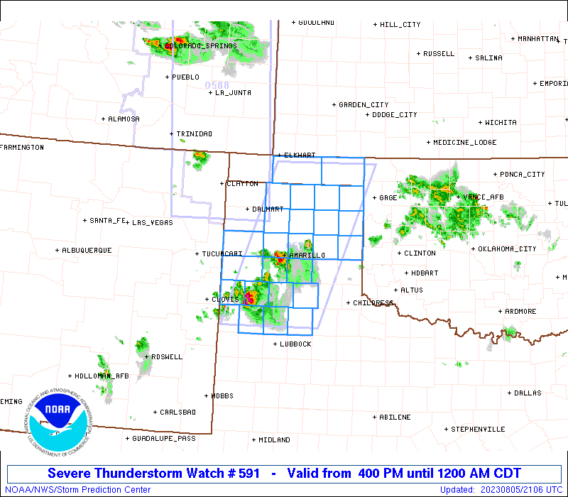
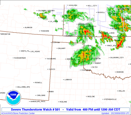
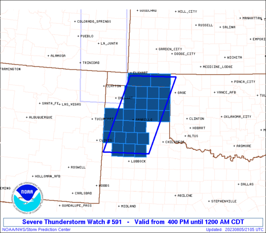
Severe Thunderstorm Watch Number 591
NWS Storm Prediction Center Norman OK
400 PM CDT Sat Aug 5 2023
The NWS Storm Prediction Center has issued a
* Severe Thunderstorm Watch for portions of
Oklahoma Panhandle
Texas Panhandle
* Effective this Saturday afternoon from 400 PM until Midnight
CDT.
* Primary threats include...
Scattered damaging winds and isolated significant gusts to 80
mph likely
Scattered large hail and isolated very large hail events to 2
inches in diameter possible
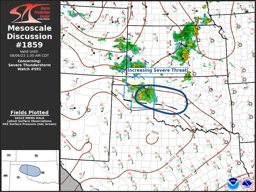
SUMMARY...Isolated severe thunderstorms are possible mainly this
afternoon with a large hail and severe gust risk. Additional storms
are forecast to develop this evening with a more significant severe
wind threat accompanying the stronger storms through the late
evening.
The severe thunderstorm watch area is approximately along and 60
statute miles east and west of a line from 40 miles east northeast
of Guymon OK to 20 miles southwest of Plainview TX. For a complete
depiction of the watch see the associated watch outline update
(WOUS64 KWNS WOU1).
PRECAUTIONARY/PREPAREDNESS ACTIONS...
REMEMBER...A Severe Thunderstorm Watch means conditions are
favorable for severe thunderstorms in and close to the watch area.
Persons in these areas should be on the lookout for threatening
weather conditions and listen for later statements and possible
warnings. Severe thunderstorms can and occasionally do produce
tornadoes.
&&
OTHER WATCH INFORMATION...CONTINUE...WW 588...WW 589...WW 590...
AVIATION...A few severe thunderstorms with hail surface and aloft to
2 inches. Extreme turbulence and surface wind gusts to 70 knots. A
few cumulonimbi with maximum tops to 500. Mean storm motion vector
27035.
...Smith
 Note:
The Aviation Watch (SAW) product is an approximation to the watch area.
The actual watch is depicted by the shaded areas.
Note:
The Aviation Watch (SAW) product is an approximation to the watch area.
The actual watch is depicted by the shaded areas.
   SAW1
   WW 591 SEVERE TSTM OK TX 052100Z - 060500Z
   AXIS..60 STATUTE MILES EAST AND WEST OF LINE..
   40ENE GUY/GUYMON OK/ - 20SW PVW/PLAINVIEW TX/
   ..AVIATION COORDS.. 50NM E/W /11SE LBL - 16N LBB/
   HAIL SURFACE AND ALOFT..2 INCHES. WIND GUSTS..70 KNOTS.
   MAX TOPS TO 500. MEAN STORM MOTION VECTOR 27035.

   LAT...LON 36899975 33960092 33960301 36890192

   THIS IS AN APPROXIMATION TO THE WATCH AREA.  FOR A
   COMPLETE DEPICTION OF THE WATCH SEE WOUS64 KWNS
   FOR WOU1.
Watch 591 Status Report Messages:
STATUS REPORT #4 ON WW 591

VALID 060050Z - 060140Z

SEVERE WEATHER THREAT CONTINUES RIGHT OF A LINE FROM 50 WNW CSM
TO 40 WSW DHT.

..LYONS..08/06/23

ATTN...WFO...AMA...LUB...

&&

STATUS REPORT FOR WS 591

SEVERE WEATHER THREAT CONTINUES FOR THE FOLLOWING AREAS

OKC007-139-060140-

OK
.    OKLAHOMA COUNTIES INCLUDED ARE

BEAVER		     TEXAS
$$


TXC195-211-233-295-341-357-393-421-060140-

TX
.    TEXAS COUNTIES INCLUDED ARE

HANSFORD	     HEMPHILL		 HUTCHINSON
LIPSCOMB	     MOORE		 OCHILTREE
ROBERTS 	     SHERMAN
$$


THE WATCH STATUS MESSAGE IS FOR GUIDANCE PURPOSES ONLY.  PLEASE
REFER TO WATCH COUNTY NOTIFICATION STATEMENTS FOR OFFICIAL
INFORMATION ON COUNTIES...INDEPENDENT CITIES AND MARINE ZONES
CLEARED FROM SEVERE THUNDERSTORM AND TORNADO WATCHES.
$$

STATUS REPORT #3 ON WW 591

VALID 052355Z - 060040Z

SEVERE WEATHER THREAT CONTINUES RIGHT OF A LINE FROM 25 NW CDS TO
20 ENE TCC.

..LYONS..08/05/23

ATTN...WFO...AMA...LUB...

&&

STATUS REPORT FOR WS 591

SEVERE WEATHER THREAT CONTINUES FOR THE FOLLOWING AREAS

OKC007-139-060040-

OK
.    OKLAHOMA COUNTIES INCLUDED ARE

BEAVER		     TEXAS
$$


TXC195-211-233-295-341-357-393-421-060040-

TX
.    TEXAS COUNTIES INCLUDED ARE

HANSFORD	     HEMPHILL		 HUTCHINSON
LIPSCOMB	     MOORE		 OCHILTREE
ROBERTS 	     SHERMAN
$$


THE WATCH STATUS MESSAGE IS FOR GUIDANCE PURPOSES ONLY.  PLEASE
REFER TO WATCH COUNTY NOTIFICATION STATEMENTS FOR OFFICIAL
INFORMATION ON COUNTIES...INDEPENDENT CITIES AND MARINE ZONES
CLEARED FROM SEVERE THUNDERSTORM AND TORNADO WATCHES.
$$

STATUS REPORT #2 ON WW 591

VALID 052245Z - 052340Z

THE SEVERE WEATHER THREAT CONTINUES ACROSS THE ENTIRE WATCH AREA.

..LYONS..08/05/23

ATTN...WFO...AMA...LUB...

&&

STATUS REPORT FOR WS 591

SEVERE WEATHER THREAT CONTINUES FOR THE FOLLOWING AREAS

OKC007-139-052340-

OK
.    OKLAHOMA COUNTIES INCLUDED ARE

BEAVER		     TEXAS
$$


TXC011-045-065-069-117-153-179-189-195-211-233-279-295-341-357-
359-369-375-381-393-421-437-483-052340-

TX
.    TEXAS COUNTIES INCLUDED ARE

ARMSTRONG	     BRISCOE		 CARSON
CASTRO		     DEAF SMITH 	 FLOYD
GRAY		     HALE		 HANSFORD
HEMPHILL	     HUTCHINSON 	 LAMB
LIPSCOMB	     MOORE		 OCHILTREE
OLDHAM		     PARMER		 POTTER
RANDALL 	     ROBERTS		 SHERMAN
SWISHER 	     WHEELER
$$


THE WATCH STATUS MESSAGE IS FOR GUIDANCE PURPOSES ONLY.  PLEASE
REFER TO WATCH COUNTY NOTIFICATION STATEMENTS FOR OFFICIAL
INFORMATION ON COUNTIES...INDEPENDENT CITIES AND MARINE ZONES
CLEARED FROM SEVERE THUNDERSTORM AND TORNADO WATCHES.
$$

STATUS REPORT #1 ON WW 591

VALID 052200Z - 052340Z

THE SEVERE WEATHER THREAT CONTINUES ACROSS THE ENTIRE WATCH AREA.

..LYONS..08/05/23

ATTN...WFO...AMA...LUB...

&&

STATUS REPORT FOR WS 591

SEVERE WEATHER THREAT CONTINUES FOR THE FOLLOWING AREAS

OKC007-139-052340-

OK
.    OKLAHOMA COUNTIES INCLUDED ARE

BEAVER		     TEXAS
$$


TXC011-045-065-069-117-153-179-189-195-211-233-279-295-341-357-
359-369-375-381-393-421-437-483-052340-

TX
.    TEXAS COUNTIES INCLUDED ARE

ARMSTRONG	     BRISCOE		 CARSON
CASTRO		     DEAF SMITH 	 FLOYD
GRAY		     HALE		 HANSFORD
HEMPHILL	     HUTCHINSON 	 LAMB
LIPSCOMB	     MOORE		 OCHILTREE
OLDHAM		     PARMER		 POTTER
RANDALL 	     ROBERTS		 SHERMAN
SWISHER 	     WHEELER
$$


THE WATCH STATUS MESSAGE IS FOR GUIDANCE PURPOSES ONLY.  PLEASE
REFER TO WATCH COUNTY NOTIFICATION STATEMENTS FOR OFFICIAL
INFORMATION ON COUNTIES...INDEPENDENT CITIES AND MARINE ZONES
CLEARED FROM SEVERE THUNDERSTORM AND TORNADO WATCHES.
$$
Note:
Click for Complete Product Text.
Tornadoes
Probability of 2 or more tornadoes
|
Low (10%)
|
Probability of 1 or more strong (EF2-EF5) tornadoes
|
Low (<2%)
|
Wind
Probability of 10 or more severe wind events
|
Mod (60%)
|
Probability of 1 or more wind events > 65 knots
|
Mod (60%)
|
Hail
Probability of 10 or more severe hail events
|
Mod (40%)
|
Probability of 1 or more hailstones > 2 inches
|
Mod (40%)
|
Combined Severe Hail/Wind
Probability of 6 or more combined severe hail/wind events
|
High (90%)
|
For each watch, probabilities for particular events inside the watch
(listed above in each table) are determined by the issuing forecaster.
The "Low" category contains probability values ranging from less than 2%
to 20% (EF2-EF5 tornadoes), less than 5% to 20% (all other probabilities),
"Moderate" from 30% to 60%, and "High" from 70% to greater than 95%.
High values are bolded and lighter in color to provide awareness of
an increased threat for a particular event.


 @NWSSPC