|
| Mesoscale Discussion 803 |
|
< Previous MD Next MD >
|
|
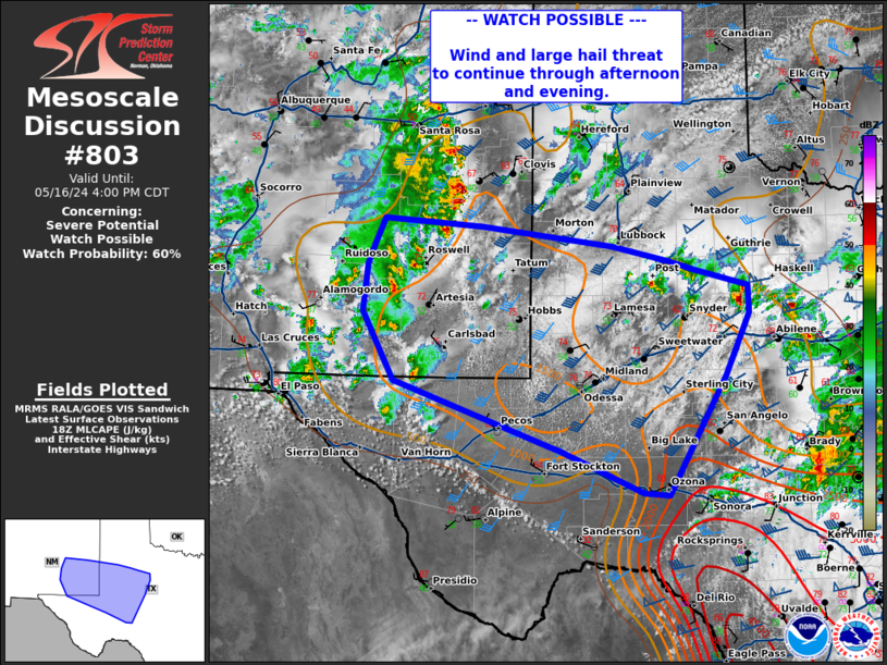
   Mesoscale Discussion 0803
   NWS Storm Prediction Center Norman OK
   0158 PM CDT Thu May 16 2024

   Areas affected...western Texas

   Concerning...Severe potential...Watch possible

   Valid 161858Z - 162100Z

   Probability of Watch Issuance...60 percent

   SUMMARY...Threat of large hail and damaging wind to continue through
   the afternoon/evening. A watch will be possible in the next couple
   of hours.

   DISCUSSION...Thunderstorm and supercell activity has increased
   across portions of eastern New Mexico into western Texas. Reports of
   hail up to 1.75" have been noted with storms near Synder, TX.
   Visible satellite shows continued development of cumulus across this
   region, with additional thunderstorm development expected through
   the afternoon.

   The environment in this region is characterized by MLCAPE 1000-1500
   J/kg and 40-45 kts of deep layer shear. Forecast soundings across
   this region depict steep lapse rates throughout the profile. The VAD
   profile from MAF shows a largely linear and elongated hodograph.
   Temperatures have warmed into the mid 70s to 80s with dew points in
   the upper 50s. Given these parameters, further development through
   the afternoon/evening will likely be capable of very large hail and
   damaging winds. A watch may be needed to encompass this threat this
   afternoon.

   ..Thornton/Thompson.. 05/16/2024

   ...Please see www.spc.noaa.gov for graphic product...

   ATTN...WFO...SJT...LUB...MAF...ABQ...EPZ...

   LAT...LON   30660153 30620118 31510067 32020038 32740005 33060007
               33250081 33340115 33530194 33760374 33850507 33530522
               33320530 32750537 31950494 31190277 31150267 30660153
|
|
Top/All Mesoscale Discussions/Forecast Products/Home
|
|


 @NWSSPC