Note:
The expiration time in the watch graphic is amended if the watch is
replaced, cancelled or extended.
Note:
Note:
The expiration time in the watch graphic is amended if the watch is
replaced, cancelled or extended.
Note: Click for
Watch Status Reports.
SEL3
URGENT - IMMEDIATE BROADCAST REQUESTED
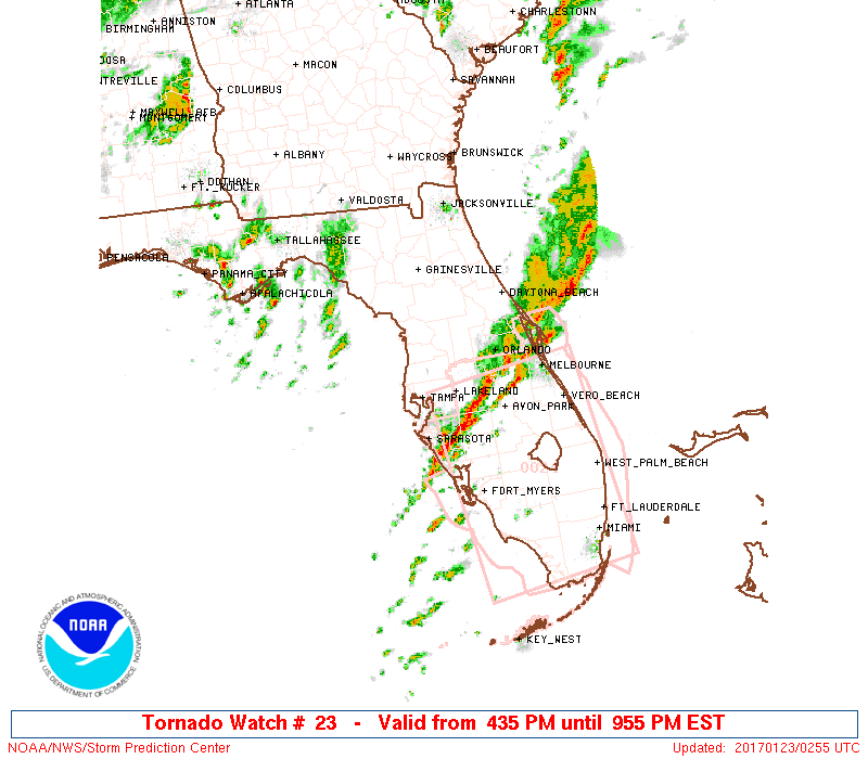
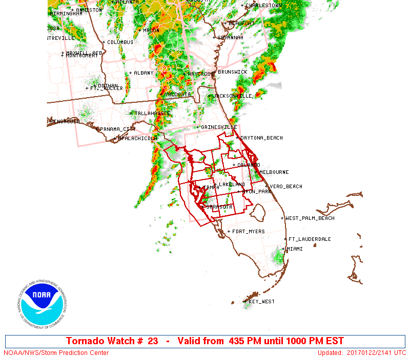
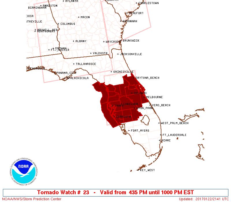
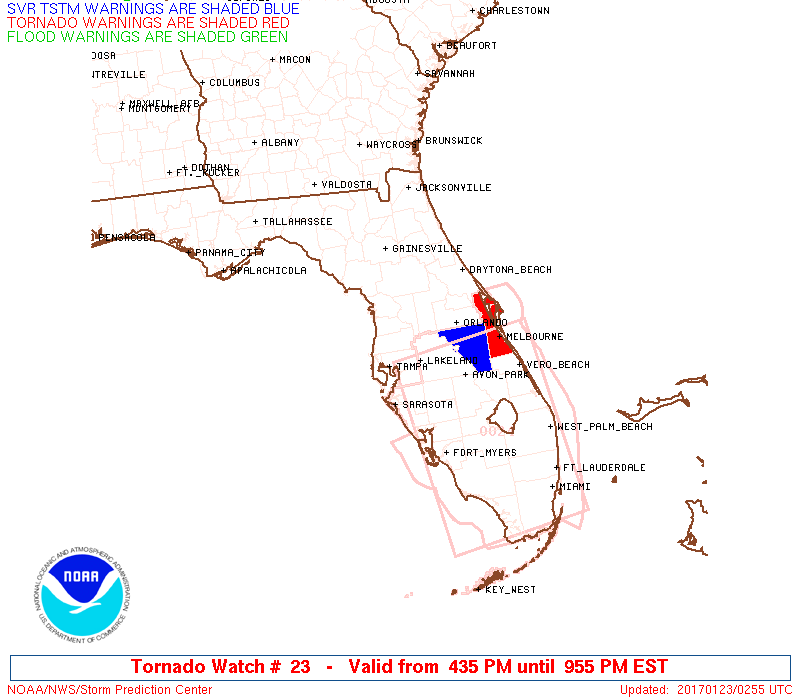
Tornado Watch Number 23
NWS Storm Prediction Center Norman OK
435 PM EST Sun Jan 22 2017
The NWS Storm Prediction Center has issued a
* Tornado Watch for portions of
Central Florida
Coastal Waters
* Effective this Sunday afternoon and evening from 435 PM until
1000 PM EST.
...THIS IS A PARTICULARLY DANGEROUS SITUATION...
* Primary threats include...
Several tornadoes and a few intense tornadoes likely
Widespread damaging wind gusts to 70 mph likely
Scattered large hail events to 1.5 inches in diameter possible
SUMMARY...A line of supercell thunderstorms over the Gulf Of Mexico
will track eastward across central FL late this afternoon and
evening, posing a risk of tornadoes and damaging wind gusts. Strong
tornadoes are possible.
The tornado watch area is approximately along and 55 statute miles
east and west of a line from 35 miles northeast of Ocala FL to 35
miles southeast of Sarasota FL. For a complete depiction of the
watch see the associated watch outline update (WOUS64 KWNS WOU3).
PRECAUTIONARY/PREPAREDNESS ACTIONS...
REMEMBER...A Tornado Watch means conditions are favorable for
tornadoes and severe thunderstorms in and close to the watch
area. Persons in these areas should be on the lookout for
threatening weather conditions and listen for later statements
and possible warnings.
&&
OTHER WATCH INFORMATION...CONTINUE...WW 21...WW 22...
AVIATION...Tornadoes and a few severe thunderstorms with hail
surface and aloft to 1.5 inches. Extreme turbulence and surface wind
gusts to 60 knots. A few cumulonimbi with maximum tops to 500. Mean
storm motion vector 25040.
...Hart

   SEL3

   URGENT - IMMEDIATE BROADCAST REQUESTED
   Tornado Watch Number 23
   NWS Storm Prediction Center Norman OK
   435 PM EST Sun Jan 22 2017

   The NWS Storm Prediction Center has issued a

   * Tornado Watch for portions of
     Central Florida
     Coastal Waters

   * Effective this Sunday afternoon and evening from 435 PM until
     1000 PM EST.

   ...THIS IS A PARTICULARLY DANGEROUS SITUATION...

   * Primary threats include...
     Several tornadoes and a few intense tornadoes likely
     Widespread damaging wind gusts to 70 mph likely
     Scattered large hail events to 1.5 inches in diameter possible

   SUMMARY...A line of supercell thunderstorms over the Gulf Of Mexico
   will track eastward across central FL late this afternoon and
   evening, posing a risk of tornadoes and damaging wind gusts.  Strong
   tornadoes are possible.

   The tornado watch area is approximately along and 55 statute miles
   east and west of a line from 35 miles northeast of Ocala FL to 35
   miles southeast of Sarasota FL. For a complete depiction of the
   watch see the associated watch outline update (WOUS64 KWNS WOU3).

   PRECAUTIONARY/PREPAREDNESS ACTIONS...

   REMEMBER...A Tornado Watch means conditions are favorable for
   tornadoes and severe thunderstorms in and close to the watch
   area. Persons in these areas should be on the lookout for
   threatening weather conditions and listen for later statements
   and possible warnings.

   &&

   OTHER WATCH INFORMATION...CONTINUE...WW 21...WW 22...

   AVIATION...Tornadoes and a few severe thunderstorms with hail
   surface and aloft to 1.5 inches. Extreme turbulence and surface wind
   gusts to 60 knots. A few cumulonimbi with maximum tops to 500. Mean
   storm motion vector 25040.

   ...Hart
 Note:
The Aviation Watch (SAW) product is an approximation to the watch area.
The actual watch is depicted by the shaded areas.
Note:
The Aviation Watch (SAW) product is an approximation to the watch area.
The actual watch is depicted by the shaded areas.
   SAW3
   WW 23 TORNADO FL CW 222135Z - 230300Z
   AXIS..55 STATUTE MILES EAST AND WEST OF LINE..
   35NE OCF/OCALA FL/ - 35SE SRQ/SARASOTA FL/
   ..AVIATION COORDS.. 50NM E/W /39WNW OMN - 30SE SRQ/
   HAIL SURFACE AND ALOFT..1.5 INCHES. WIND GUSTS..60 KNOTS.
   MAX TOPS TO 500. MEAN STORM MOTION VECTOR 25040.

   LAT...LON 29528088 27048125 27048304 29528272

   THIS IS AN APPROXIMATION TO THE WATCH AREA.  FOR A
   COMPLETE DEPICTION OF THE WATCH SEE WOUS64 KWNS
   FOR WOU3.
Watch 23 Status Report Messages:
STATUS REPORT #3 ON WW 23

VALID 230045Z - 230140Z

SEVERE WEATHER THREAT CONTINUES RIGHT OF A LINE FROM 20 WNW PIE
TO 30 ESE OCF TO 35 SSW SGJ.

..GOSS..01/23/17

ATTN...WFO...MLB...TBW...

&&

STATUS REPORT FOR WT 23

SEVERE WEATHER THREAT CONTINUES FOR THE FOLLOWING AREAS

FLC009-027-049-053-055-057-069-081-095-097-101-103-105-115-117-
119-127-230140-

FL
.    FLORIDA COUNTIES INCLUDED ARE

BREVARD 	     DESOTO		 HARDEE
HERNANDO	     HIGHLANDS		 HILLSBOROUGH
LAKE		     MANATEE		 ORANGE
OSCEOLA 	     PASCO		 PINELLAS
POLK		     SARASOTA		 SEMINOLE
SUMTER		     VOLUSIA
$$


GMZ830-853-230140-

CW

.    ADJACENT COASTAL WATERS INCLUDED ARE

TAMPA BAY WATERS

COASTAL WATERS FROM ENGLEWOOD TO TARPON SPRINGS FL OUT 20 NM

$$
THE WATCH STATUS MESSAGE IS FOR GUIDANCE PURPOSES ONLY.  PLEASE
REFER TO WATCH COUNTY NOTIFICATION STATEMENTS FOR OFFICIAL
INFORMATION ON COUNTIES...INDEPENDENT CITIES AND MARINE ZONES
CLEARED FROM SEVERE THUNDERSTORM AND TORNADO WATCHES.
$$

STATUS REPORT #2 ON WW 23

VALID 222330Z - 230040Z

SEVERE WEATHER THREAT CONTINUES RIGHT OF A LINE FROM 50 SW OCF TO
15 W OCF TO 10 SW GNV.

..GOSS..01/22/17

ATTN...WFO...MLB...TBW...

&&

STATUS REPORT FOR WT 23

SEVERE WEATHER THREAT CONTINUES FOR THE FOLLOWING AREAS

FLC009-017-027-049-053-055-057-069-081-095-097-101-103-105-115-
117-119-127-230040-

FL
.    FLORIDA COUNTIES INCLUDED ARE

BREVARD 	     CITRUS		 DESOTO
HARDEE		     HERNANDO		 HIGHLANDS
HILLSBOROUGH	     LAKE		 MANATEE
ORANGE		     OSCEOLA		 PASCO
PINELLAS	     POLK		 SARASOTA
SEMINOLE	     SUMTER		 VOLUSIA
$$


GMZ830-850-853-230040-

CW

.    ADJACENT COASTAL WATERS INCLUDED ARE

TAMPA BAY WATERS

COASTAL WATERS FROM TARPON SPRINGS TO SUWANNEE RIVER FL OUT 20 NM

COASTAL WATERS FROM ENGLEWOOD TO TARPON SPRINGS FL OUT 20 NM

$$
THE WATCH STATUS MESSAGE IS FOR GUIDANCE PURPOSES ONLY.  PLEASE
REFER TO WATCH COUNTY NOTIFICATION STATEMENTS FOR OFFICIAL
INFORMATION ON COUNTIES...INDEPENDENT CITIES AND MARINE ZONES
CLEARED FROM SEVERE THUNDERSTORM AND TORNADO WATCHES.
$$

STATUS REPORT #1 ON WW 23

VALID 222250Z - 222340Z

THE SEVERE WEATHER THREAT CONTINUES ACROSS THE ENTIRE WATCH AREA.

..GOSS..01/22/17

ATTN...WFO...MLB...TBW...

&&

STATUS REPORT FOR WT 23

SEVERE WEATHER THREAT CONTINUES FOR THE FOLLOWING AREAS

FLC009-017-027-049-053-055-057-069-081-095-097-101-103-105-115-
117-119-127-222340-

FL
.    FLORIDA COUNTIES INCLUDED ARE

BREVARD 	     CITRUS		 DESOTO
HARDEE		     HERNANDO		 HIGHLANDS
HILLSBOROUGH	     LAKE		 MANATEE
ORANGE		     OSCEOLA		 PASCO
PINELLAS	     POLK		 SARASOTA
SEMINOLE	     SUMTER		 VOLUSIA
$$


GMZ830-850-853-222340-

CW

.    ADJACENT COASTAL WATERS INCLUDED ARE

TAMPA BAY WATERS

COASTAL WATERS FROM TARPON SPRINGS TO SUWANNEE RIVER FL OUT 20 NM

COASTAL WATERS FROM ENGLEWOOD TO TARPON SPRINGS FL OUT 20 NM

$$
THE WATCH STATUS MESSAGE IS FOR GUIDANCE PURPOSES ONLY.  PLEASE
REFER TO WATCH COUNTY NOTIFICATION STATEMENTS FOR OFFICIAL
INFORMATION ON COUNTIES...INDEPENDENT CITIES AND MARINE ZONES
CLEARED FROM SEVERE THUNDERSTORM AND TORNADO WATCHES.
$$
Note:
Click for Complete Product Text.
Tornadoes
Probability of 2 or more tornadoes
|
High (80%)
|
Probability of 1 or more strong (F2-F5) tornadoes
|
High (80%)
|
Wind
Probability of 10 or more severe wind events
|
High (80%)
|
Probability of 1 or more wind events > 65 knots
|
Low (10%)
|
Hail
Probability of 10 or more severe hail events
|
Mod (50%)
|
Probability of 1 or more hailstones > 2 inches
|
Low (10%)
|
Combined Severe Hail/Wind
Probability of 6 or more combined severe hail/wind events
|
High (90%)
|
For each watch, probabilities for particular events inside the watch
(listed above in each table) are determined by the issuing forecaster.
The "Low" category contains probability values ranging from less than 2%
to 20% (F2-F5 tornadoes), less than 5% to 20% (all other probabilities),
"Moderate" from 30% to 60%, and "High" from 70% to greater than 95%.
High values are bolded and lighter in color to provide awareness of
an increased threat for a particular event.


 @NWSSPC