 Note:
The expiration time in the watch graphic is amended if the watch is
replaced, cancelled or extended.
Note:
Note:
The expiration time in the watch graphic is amended if the watch is
replaced, cancelled or extended.
Note: Click for
Watch Status Reports.
SEL4
URGENT - IMMEDIATE BROADCAST REQUESTED
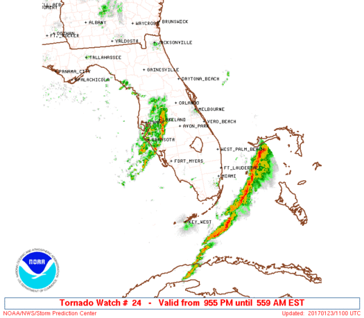
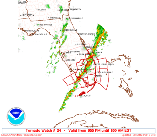
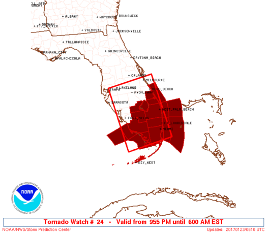
Tornado Watch Number 24
NWS Storm Prediction Center Norman OK
955 PM EST Sun Jan 22 2017
The NWS Storm Prediction Center has issued a
* Tornado Watch for portions of
Central and South Florida
Coastal Waters
* Effective this Sunday night and Monday morning from 955 PM
until 600 AM EST.
* Primary threats include...
A couple tornadoes possible
Isolated damaging wind gusts to 70 mph possible
Isolated large hail events to 1.5 inches in diameter possible
SUMMARY...A lingering threat for severe thunderstorms will shift
southeastward down the peninsula overnight, both from the main band
of thunderstorms initially across central Florida and relatively
discrete cells moving off the Gulf. Instability, moisture and
vertical shear all will remain favorable for several more hours at
least. The risk exists for damaging gusts, isolated large hail and
a couple of tornadoes.
The tornado watch area is approximately along and 70 statute miles
either side of a line from 35 miles north of Avon Park FL to 55
miles southwest of Miami FL. For a complete depiction of the watch
see the associated watch outline update (WOUS64 KWNS WOU4).
PRECAUTIONARY/PREPAREDNESS ACTIONS...
REMEMBER...A Tornado Watch means conditions are favorable for
tornadoes and severe thunderstorms in and close to the watch
area. Persons in these areas should be on the lookout for
threatening weather conditions and listen for later statements
and possible warnings.
&&
OTHER WATCH INFORMATION...This tornado watch replaces tornado
watch number 23. Watch number 23 will not be in effect after 955
PM EST.
AVIATION...Tornadoes and a few severe thunderstorms with hail
surface and aloft to 1.5 inches. Extreme turbulence and surface wind
gusts to 60 knots. A few cumulonimbi with maximum tops to 450. Mean
storm motion vector 25030.
...Edwards
   SEL4

   URGENT - IMMEDIATE BROADCAST REQUESTED
   Tornado Watch Number 24
   NWS Storm Prediction Center Norman OK
   955 PM EST Sun Jan 22 2017

   The NWS Storm Prediction Center has issued a

   * Tornado Watch for portions of
     Central and South Florida
     Coastal Waters

   * Effective this Sunday night and Monday morning from 955 PM
     until 600 AM EST.

   * Primary threats include...
     A couple tornadoes possible
     Isolated damaging wind gusts to 70 mph possible
     Isolated large hail events to 1.5 inches in diameter possible

   SUMMARY...A lingering threat for severe thunderstorms will shift
   southeastward down the peninsula overnight, both from the main band
   of thunderstorms initially across central Florida and relatively
   discrete cells moving off the Gulf.  Instability, moisture and
   vertical shear all will remain favorable for several more hours at
   least.  The risk exists for damaging gusts, isolated large hail and
   a couple of tornadoes.

   The tornado watch area is approximately along and 70 statute miles
   either side of a line from 35 miles north of Avon Park FL to 55
   miles southwest of Miami FL. For a complete depiction of the watch
   see the associated watch outline update (WOUS64 KWNS WOU4).

   PRECAUTIONARY/PREPAREDNESS ACTIONS...

   REMEMBER...A Tornado Watch means conditions are favorable for
   tornadoes and severe thunderstorms in and close to the watch
   area. Persons in these areas should be on the lookout for
   threatening weather conditions and listen for later statements
   and possible warnings.

   &&

   OTHER WATCH INFORMATION...This tornado watch replaces tornado
   watch number 23. Watch number 23 will not be in effect after 955
   PM EST.

   AVIATION...Tornadoes and a few severe thunderstorms with hail
   surface and aloft to 1.5 inches. Extreme turbulence and surface wind
   gusts to 60 knots. A few cumulonimbi with maximum tops to 450. Mean
   storm motion vector 25030.

   ...Edwards
 Note:
The Aviation Watch (SAW) product is an approximation to the watch area.
The actual watch is depicted by the shaded areas.
Note:
The Aviation Watch (SAW) product is an approximation to the watch area.
The actual watch is depicted by the shaded areas.
   SAW4
   WW 24 TORNADO FL CW 230255Z - 231100Z
   AXIS..70 STATUTE MILES EITHER SIDE OF LINE..
   35N AGR/AVON PARK FL/ - 55SW MIA/MIAMI FL/
   ..AVIATION COORDS.. 60NM EITHER SIDE /23S ORL - 47SW MIA/
   HAIL SURFACE AND ALOFT..1.5 INCHES. WIND GUSTS..60 KNOTS.
   MAX TOPS TO 450. MEAN STORM MOTION VECTOR 25030.

   REPLACES WW 23..FL CW

   LAT...LON 28328019 25407980 25058200 27978245

   THIS IS AN APPROXIMATION TO THE WATCH AREA.  FOR A
   COMPLETE DEPICTION OF THE WATCH SEE WOUS64 KWNS
   FOR WOU4.
Watch 24 Status Report Messages:
STATUS REPORT #6 ON WW 24

VALID 230945Z - 231040Z

SEVERE WEATHER THREAT CONTINUES RIGHT OF A LINE FROM 35 S MIA TO
30 NE MIA.

FOR ADDITIONAL INFORMATION SEE MESOSCALE DISCUSSION 129.

..PETERS..01/23/17

ATTN...WFO...MLB...MFL...TBW...

&&

STATUS REPORT FOR WT 24

SEVERE WEATHER THREAT CONTINUES FOR THE FOLLOWING AREAS

AMZ651-670-671-231040-

CW

.    ADJACENT COASTAL WATERS INCLUDED ARE

COASTAL WATERS FROM DEERFIELD BEACH TO OCEAN REEF FL OUT 20 NM

WATERS FROM JUPITER INLET TO DEERFIELD BEACH FL FROM 20 TO 60 NM

WATERS FROM DEERFIELD BEACH TO OCEAN REEF FL FROM 20 TO 60 NM
EXCLUDING THE TERRITORIAL WATERS OF BAHAMAS

$$
THE WATCH STATUS MESSAGE IS FOR GUIDANCE PURPOSES ONLY.  PLEASE
REFER TO WATCH COUNTY NOTIFICATION STATEMENTS FOR OFFICIAL
INFORMATION ON COUNTIES...INDEPENDENT CITIES AND MARINE ZONES
CLEARED FROM SEVERE THUNDERSTORM AND TORNADO WATCHES.
$$

STATUS REPORT #5 ON WW 24

VALID 230850Z - 230940Z

SEVERE WEATHER THREAT CONTINUES RIGHT OF A LINE FROM 30 N MTH TO
20 NW MIA TO 15 SSE PBI.

..PETERS..01/23/17

ATTN...WFO...MLB...MFL...TBW...

&&

STATUS REPORT FOR WT 24

SEVERE WEATHER THREAT CONTINUES FOR THE FOLLOWING AREAS

FLC011-086-087-230940-

FL
.    FLORIDA COUNTIES INCLUDED ARE

BROWARD 	     MIAMI-DADE 	 MONROE
$$


AMZ630-650-651-670-671-230940-

CW

.    ADJACENT COASTAL WATERS INCLUDED ARE

BISCAYNE BAY

COASTAL WATERS FROM JUPITER INLET TO DEERFIELD BEACH FL OUT 20 NM

COASTAL WATERS FROM DEERFIELD BEACH TO OCEAN REEF FL OUT 20 NM

WATERS FROM JUPITER INLET TO DEERFIELD BEACH FL FROM 20 TO 60 NM

WATERS FROM DEERFIELD BEACH TO OCEAN REEF FL FROM 20 TO 60 NM
EXCLUDING THE TERRITORIAL WATERS OF BAHAMAS

$$
THE WATCH STATUS MESSAGE IS FOR GUIDANCE PURPOSES ONLY.  PLEASE
REFER TO WATCH COUNTY NOTIFICATION STATEMENTS FOR OFFICIAL
INFORMATION ON COUNTIES...INDEPENDENT CITIES AND MARINE ZONES
CLEARED FROM SEVERE THUNDERSTORM AND TORNADO WATCHES.
$$

STATUS REPORT #4 ON WW 24

VALID 230740Z - 230840Z

SEVERE WEATHER THREAT CONTINUES RIGHT OF A LINE FROM 35 NNW EYW
TO 25 N PBI.

FOR ADDITIONAL INFORMATION SEE MESOSCALE DISCUSSION 128.

..PETERS..01/23/17

ATTN...WFO...MLB...MFL...TBW...

&&

STATUS REPORT FOR WT 24

SEVERE WEATHER THREAT CONTINUES FOR THE FOLLOWING AREAS

FLC011-086-087-099-230840-

FL
.    FLORIDA COUNTIES INCLUDED ARE

BROWARD 	     MIAMI-DADE 	 MONROE
PALM BEACH
$$


AMZ630-650-651-670-671-GMZ657-230840-

CW

.    ADJACENT COASTAL WATERS INCLUDED ARE

BISCAYNE BAY

COASTAL WATERS FROM JUPITER INLET TO DEERFIELD BEACH FL OUT 20 NM

COASTAL WATERS FROM DEERFIELD BEACH TO OCEAN REEF FL OUT 20 NM

WATERS FROM JUPITER INLET TO DEERFIELD BEACH FL FROM 20 TO 60 NM

WATERS FROM DEERFIELD BEACH TO OCEAN REEF FL FROM 20 TO 60 NM
EXCLUDING THE TERRITORIAL WATERS OF BAHAMAS

COASTAL WATERS FROM EAST CAPE SABLE TO CHOKOLOSKEE FL OUT 20 NM

$$
THE WATCH STATUS MESSAGE IS FOR GUIDANCE PURPOSES ONLY.  PLEASE
REFER TO WATCH COUNTY NOTIFICATION STATEMENTS FOR OFFICIAL
INFORMATION ON COUNTIES...INDEPENDENT CITIES AND MARINE ZONES
CLEARED FROM SEVERE THUNDERSTORM AND TORNADO WATCHES.
$$

STATUS REPORT #3 ON WW 24

VALID 230635Z - 230740Z

SEVERE WEATHER THREAT CONTINUES RIGHT OF A LINE FROM 35 SW APF TO
20 E VRB.

..PETERS..01/23/17

ATTN...WFO...MLB...MFL...TBW...

&&

STATUS REPORT FOR WT 24

SEVERE WEATHER THREAT CONTINUES FOR THE FOLLOWING AREAS

FLC011-021-051-085-086-087-099-111-230740-

FL
.    FLORIDA COUNTIES INCLUDED ARE

BROWARD 	     COLLIER		 HENDRY
MARTIN		     MIAMI-DADE 	 MONROE
PALM BEACH	     ST. LUCIE
$$


AMZ555-610-630-650-651-670-671-GMZ656-657-230740-

CW

.    ADJACENT COASTAL WATERS INCLUDED ARE

SEBASTIAN INLET TO JUPITER INLET 0-20 NM

LAKE OKEECHOBEE

BISCAYNE BAY

COASTAL WATERS FROM JUPITER INLET TO DEERFIELD BEACH FL OUT 20 NM

COASTAL WATERS FROM DEERFIELD BEACH TO OCEAN REEF FL OUT 20 NM

WATERS FROM JUPITER INLET TO DEERFIELD BEACH FL FROM 20 TO 60 NM

WATERS FROM DEERFIELD BEACH TO OCEAN REEF FL FROM 20 TO 60 NM
EXCLUDING THE TERRITORIAL WATERS OF BAHAMAS

COASTAL WATERS FROM CHOKOLOSKEE TO BONITA BEACH FL OUT 20 NM

COASTAL WATERS FROM EAST CAPE SABLE TO CHOKOLOSKEE FL OUT 20 NM

$$
THE WATCH STATUS MESSAGE IS FOR GUIDANCE PURPOSES ONLY.  PLEASE
REFER TO WATCH COUNTY NOTIFICATION STATEMENTS FOR OFFICIAL
INFORMATION ON COUNTIES...INDEPENDENT CITIES AND MARINE ZONES
CLEARED FROM SEVERE THUNDERSTORM AND TORNADO WATCHES.
$$

STATUS REPORT #2 ON WW 24

VALID 230520Z - 230640Z

SEVERE WEATHER THREAT CONTINUES RIGHT OF A LINE FROM 35 SW APF TO
30 ENE MLB.

..GOSS..01/23/17

ATTN...WFO...MLB...MFL...TBW...

&&

STATUS REPORT FOR WT 24

SEVERE WEATHER THREAT CONTINUES FOR THE FOLLOWING AREAS

FLC011-021-043-051-061-085-086-087-093-099-111-230640-

FL
.    FLORIDA COUNTIES INCLUDED ARE

BROWARD 	     COLLIER		 GLADES
HENDRY		     INDIAN RIVER	 MARTIN
MIAMI-DADE	     MONROE		 OKEECHOBEE
PALM BEACH	     ST. LUCIE
$$


AMZ555-610-630-650-651-670-671-GMZ656-657-676-230640-

CW

.    ADJACENT COASTAL WATERS INCLUDED ARE

SEBASTIAN INLET TO JUPITER INLET 0-20 NM

LAKE OKEECHOBEE

BISCAYNE BAY

COASTAL WATERS FROM JUPITER INLET TO DEERFIELD BEACH FL OUT 20 NM

COASTAL WATERS FROM DEERFIELD BEACH TO OCEAN REEF FL OUT 20 NM

WATERS FROM JUPITER INLET TO DEERFIELD BEACH FL FROM 20 TO 60 NM

WATERS FROM DEERFIELD BEACH TO OCEAN REEF FL FROM 20 TO 60 NM
EXCLUDING THE TERRITORIAL WATERS OF BAHAMAS

COASTAL WATERS FROM CHOKOLOSKEE TO BONITA BEACH FL OUT 20 NM

COASTAL WATERS FROM EAST CAPE SABLE TO CHOKOLOSKEE FL OUT 20 NM

WATERS FROM CHOKOLOSKEE TO BONITA BEACH FL FROM 20 TO 60 NM

$$
THE WATCH STATUS MESSAGE IS FOR GUIDANCE PURPOSES ONLY.  PLEASE
REFER TO WATCH COUNTY NOTIFICATION STATEMENTS FOR OFFICIAL
INFORMATION ON COUNTIES...INDEPENDENT CITIES AND MARINE ZONES
CLEARED FROM SEVERE THUNDERSTORM AND TORNADO WATCHES.
$$

STATUS REPORT #1 ON WW 24

VALID 230440Z - 230540Z

SEVERE WEATHER THREAT CONTINUES RIGHT OF A LINE FROM 30 SW FMY TO
20 NE MLB.

..GOSS..01/23/17

ATTN...WFO...MLB...MFL...TBW...

&&

STATUS REPORT FOR WT 24

SEVERE WEATHER THREAT CONTINUES FOR THE FOLLOWING AREAS

FLC009-011-021-043-051-055-061-071-085-086-087-093-097-099-111-
230540-

FL
.    FLORIDA COUNTIES INCLUDED ARE

BREVARD 	     BROWARD		 COLLIER
GLADES		     HENDRY		 HIGHLANDS
INDIAN RIVER	     LEE		 MARTIN
MIAMI-DADE	     MONROE		 OKEECHOBEE
OSCEOLA 	     PALM BEACH 	 ST. LUCIE
$$


AMZ552-555-610-630-650-651-670-671-GMZ656-657-676-230540-

CW

.    ADJACENT COASTAL WATERS INCLUDED ARE

VOLUSIA-BREVARD COUNTY LINE TO SEBASTIAN INLET 0-20 NM

SEBASTIAN INLET TO JUPITER INLET 0-20 NM

LAKE OKEECHOBEE

BISCAYNE BAY

COASTAL WATERS FROM JUPITER INLET TO DEERFIELD BEACH FL OUT 20 NM

COASTAL WATERS FROM DEERFIELD BEACH TO OCEAN REEF FL OUT 20 NM

WATERS FROM JUPITER INLET TO DEERFIELD BEACH FL FROM 20 TO 60 NM

WATERS FROM DEERFIELD BEACH TO OCEAN REEF FL FROM 20 TO 60 NM
EXCLUDING THE TERRITORIAL WATERS OF BAHAMAS

COASTAL WATERS FROM CHOKOLOSKEE TO BONITA BEACH FL OUT 20 NM

COASTAL WATERS FROM EAST CAPE SABLE TO CHOKOLOSKEE FL OUT 20 NM

WATERS FROM CHOKOLOSKEE TO BONITA BEACH FL FROM 20 TO 60 NM

$$
THE WATCH STATUS MESSAGE IS FOR GUIDANCE PURPOSES ONLY.  PLEASE
REFER TO WATCH COUNTY NOTIFICATION STATEMENTS FOR OFFICIAL
INFORMATION ON COUNTIES...INDEPENDENT CITIES AND MARINE ZONES
CLEARED FROM SEVERE THUNDERSTORM AND TORNADO WATCHES.
$$
Note:
Click for Complete Product Text.
Tornadoes
Probability of 2 or more tornadoes
|
Mod (30%)
|
Probability of 1 or more strong (F2-F5) tornadoes
|
Low (20%)
|
Wind
Probability of 10 or more severe wind events
|
Mod (30%)
|
Probability of 1 or more wind events > 65 knots
|
Low (10%)
|
Hail
Probability of 10 or more severe hail events
|
Low (20%)
|
Probability of 1 or more hailstones > 2 inches
|
Low (10%)
|
Combined Severe Hail/Wind
Probability of 6 or more combined severe hail/wind events
|
Mod (60%)
|
For each watch, probabilities for particular events inside the watch
(listed above in each table) are determined by the issuing forecaster.
The "Low" category contains probability values ranging from less than 2%
to 20% (F2-F5 tornadoes), less than 5% to 20% (all other probabilities),
"Moderate" from 30% to 60%, and "High" from 70% to greater than 95%.
High values are bolded and lighter in color to provide awareness of
an increased threat for a particular event.


 @NWSSPC


