 Note:
The expiration time in the watch graphic is amended if the watch is
replaced, cancelled or extended.
Note:
Note:
The expiration time in the watch graphic is amended if the watch is
replaced, cancelled or extended.
Note: Click for
Watch Status Reports.
SEL1
URGENT - IMMEDIATE BROADCAST REQUESTED
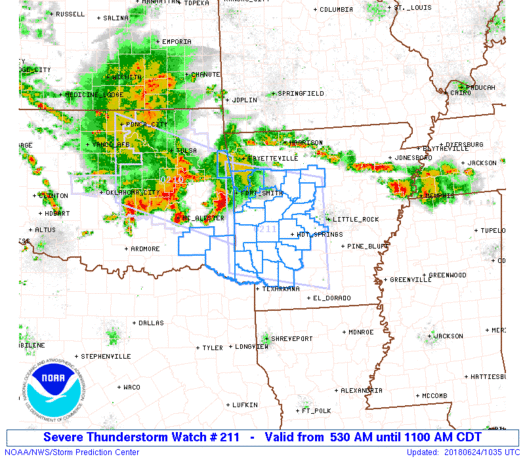
Severe Thunderstorm Watch Number 211
NWS Storm Prediction Center Norman OK
530 AM CDT Sun Jun 24 2018
The NWS Storm Prediction Center has issued a
* Severe Thunderstorm Watch for portions of
Western and central Arkansas
Far eastern Oklahoma
* Effective this Sunday morning from 530 AM until 1100 AM CDT.
* Primary threats include...
Scattered damaging wind gusts to 70 mph possible
Isolated large hail events to 1.5 inches in diameter possible
SUMMARY...A well-organized convective line will continue to quickly
progress east/southeastward from eastern Oklahoma into Arkansas this
morning, with additional strong to severe storms preceding this line
of storms. Damaging winds will be the primary concern but some hail
is also possible.
The severe thunderstorm watch area is approximately along and 75
statute miles north and south of a line from 35 miles south
southwest of Fort Smith AR to 45 miles east of Hot Springs AR. For a
complete depiction of the watch see the associated watch outline
update (WOUS64 KWNS WOU1).
PRECAUTIONARY/PREPAREDNESS ACTIONS...
REMEMBER...A Severe Thunderstorm Watch means conditions are
favorable for severe thunderstorms in and close to the watch area.
Persons in these areas should be on the lookout for threatening
weather conditions and listen for later statements and possible
warnings. Severe thunderstorms can and occasionally do produce
tornadoes.
&&
OTHER WATCH INFORMATION...CONTINUE...WW 210...
AVIATION...A few severe thunderstorms with hail surface and aloft to
1.5 inches. Extreme turbulence and surface wind gusts to 60 knots. A
few cumulonimbi with maximum tops to 550. Mean storm motion vector
29040.
...Guyer

   SEL1

   URGENT - IMMEDIATE BROADCAST REQUESTED
   Severe Thunderstorm Watch Number 211
   NWS Storm Prediction Center Norman OK
   530 AM CDT Sun Jun 24 2018

   The NWS Storm Prediction Center has issued a

   * Severe Thunderstorm Watch for portions of
     Western and central Arkansas
     Far eastern Oklahoma

   * Effective this Sunday morning from 530 AM until 1100 AM CDT.

   * Primary threats include...
     Scattered damaging wind gusts to 70 mph possible
     Isolated large hail events to 1.5 inches in diameter possible

   SUMMARY...A well-organized convective line will continue to quickly
   progress east/southeastward from eastern Oklahoma into Arkansas this
   morning, with additional strong to severe storms preceding this line
   of storms. Damaging winds will be the primary concern but some hail
   is also possible.

   The severe thunderstorm watch area is approximately along and 75
   statute miles north and south of a line from 35 miles south
   southwest of Fort Smith AR to 45 miles east of Hot Springs AR. For a
   complete depiction of the watch see the associated watch outline
   update (WOUS64 KWNS WOU1).

   PRECAUTIONARY/PREPAREDNESS ACTIONS...

   REMEMBER...A Severe Thunderstorm Watch means conditions are
   favorable for severe thunderstorms in and close to the watch area.
   Persons in these areas should be on the lookout for threatening
   weather conditions and listen for later statements and possible
   warnings. Severe thunderstorms can and occasionally do produce
   tornadoes.

   &&

   OTHER WATCH INFORMATION...CONTINUE...WW 210...

   AVIATION...A few severe thunderstorms with hail surface and aloft to
   1.5 inches. Extreme turbulence and surface wind gusts to 60 knots. A
   few cumulonimbi with maximum tops to 550. Mean storm motion vector
   29040.

   ...Guyer
 Note:
The Aviation Watch (SAW) product is an approximation to the watch area.
The actual watch is depicted by the shaded areas.
Note:
The Aviation Watch (SAW) product is an approximation to the watch area.
The actual watch is depicted by the shaded areas.
SAW1
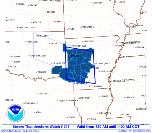
WW 211 SEVERE TSTM AR OK 241030Z - 241600Z
AXIS..75 STATUTE MILES NORTH AND SOUTH OF LINE..
35SSW FSM/FORT SMITH AR/ - 45E HOT/HOT SPRINGS AR/
..AVIATION COORDS.. 65NM N/S /35SSW FSM - 14SSW LIT/
HAIL SURFACE AND ALOFT..1.5 INCHES. WIND GUSTS..60 KNOTS.
MAX TOPS TO 550. MEAN STORM MOTION VECTOR 29040.
LAT...LON 35959461 35549230 33389230 33779461
THIS IS AN APPROXIMATION TO THE WATCH AREA. FOR A
COMPLETE DEPICTION OF THE WATCH SEE WOUS64 KWNS
FOR WOU1.
Watch 211 Status Report Messages:
STATUS REPORT #1 ON WW 211

VALID 241345Z - 241440Z

SEVERE WEATHER THREAT CONTINUES RIGHT OF A LINE FROM 30 NNE PRX
TO 45 NW HOT TO 30 SW FLP.

..PICCA..06/24/18

ATTN...WFO...LZK...TSA...SHV...

&&

STATUS REPORT FOR WS 211

SEVERE WEATHER THREAT CONTINUES FOR THE FOLLOWING AREAS

ARC019-029-051-057-059-061-081-097-099-105-109-113-115-125-133-
141-149-241440-

AR
.    ARKANSAS COUNTIES INCLUDED ARE

CLARK		     CONWAY		 GARLAND
HEMPSTEAD	     HOT SPRING 	 HOWARD
LITTLE RIVER	     MONTGOMERY 	 NEVADA
PERRY		     PIKE		 POLK
POPE		     SALINE		 SEVIER
VAN BUREN	     YELL
$$


OKC089-241440-

OK
.    OKLAHOMA COUNTIES INCLUDED ARE

MCCURTAIN
$$


THE WATCH STATUS MESSAGE IS FOR GUIDANCE PURPOSES ONLY.  PLEASE
REFER TO WATCH COUNTY NOTIFICATION STATEMENTS FOR OFFICIAL
INFORMATION ON COUNTIES...INDEPENDENT CITIES AND MARINE ZONES
CLEARED FROM SEVERE THUNDERSTORM AND TORNADO WATCHES.
$$
Note:
Click for Complete Product Text.
Tornadoes
Probability of 2 or more tornadoes
|
Low (10%)
|
Probability of 1 or more strong (F2-F5) tornadoes
|
Low (<2%)
|
Wind
Probability of 10 or more severe wind events
|
Mod (40%)
|
Probability of 1 or more wind events > 65 knots
|
Low (20%)
|
Hail
Probability of 10 or more severe hail events
|
Low (20%)
|
Probability of 1 or more hailstones > 2 inches
|
Low (10%)
|
Combined Severe Hail/Wind
Probability of 6 or more combined severe hail/wind events
|
High (70%)
|
For each watch, probabilities for particular events inside the watch
(listed above in each table) are determined by the issuing forecaster.
The "Low" category contains probability values ranging from less than 2%
to 20% (F2-F5 tornadoes), less than 5% to 20% (all other probabilities),
"Moderate" from 30% to 60%, and "High" from 70% to greater than 95%.
High values are bolded and lighter in color to provide awareness of
an increased threat for a particular event.


 @NWSSPC


