 Note:
The expiration time in the watch graphic is amended if the watch is
replaced, cancelled or extended.
Note:
Note:
The expiration time in the watch graphic is amended if the watch is
replaced, cancelled or extended.
Note: Click for
Watch Status Reports.
SEL0
URGENT - IMMEDIATE BROADCAST REQUESTED
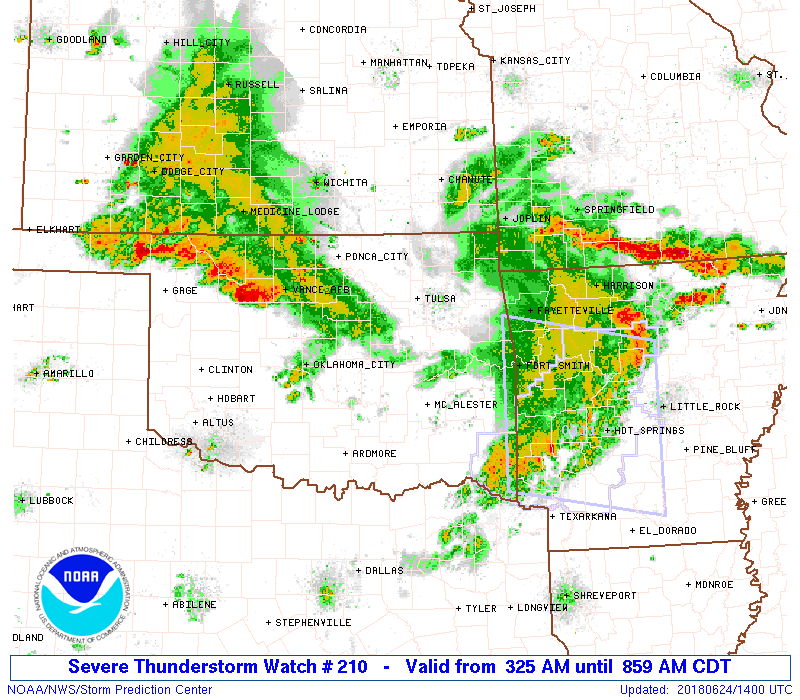
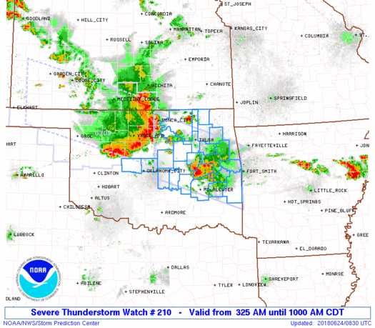
Severe Thunderstorm Watch Number 210
NWS Storm Prediction Center Norman OK
325 AM CDT Sun Jun 24 2018
The NWS Storm Prediction Center has issued a
* Severe Thunderstorm Watch for portions of
North-central and Eastern Oklahoma
* Effective this Sunday morning from 325 AM until 1000 AM CDT.
* Primary threats include...
Scattered damaging winds and isolated significant gusts to 75
mph possible
Isolated large hail events to 1.5 inches in diameter possible
A tornado or two possible
SUMMARY...A well-organized and intense convective line, with history
of measured 65+ mph wind gusts, will continue generally
southeastward across north-central and eastern Oklahoma through the
early morning hours. Pockets of wind damage can be expected along
with a few instances of hail. A brief line-embedded tornado cannot
be entirely ruled out.
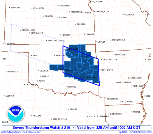
The severe thunderstorm watch area is approximately along and 60
statute miles north and south of a line from 15 miles northeast of
Poteau OK to 35 miles northwest of Chandler OK. For a complete
depiction of the watch see the associated watch outline update
(WOUS64 KWNS WOU0).
PRECAUTIONARY/PREPAREDNESS ACTIONS...
REMEMBER...A Severe Thunderstorm Watch means conditions are
favorable for severe thunderstorms in and close to the watch area.
Persons in these areas should be on the lookout for threatening
weather conditions and listen for later statements and possible
warnings. Severe thunderstorms can and occasionally do produce
tornadoes.
&&
OTHER WATCH INFORMATION...CONTINUE...WW 209...
AVIATION...A few severe thunderstorms with hail surface and aloft to
1.5 inches. Extreme turbulence and surface wind gusts to 65 knots. A
few cumulonimbi with maximum tops to 550. Mean storm motion vector
30040.
...Guyer

SEL0
URGENT - IMMEDIATE BROADCAST REQUESTED
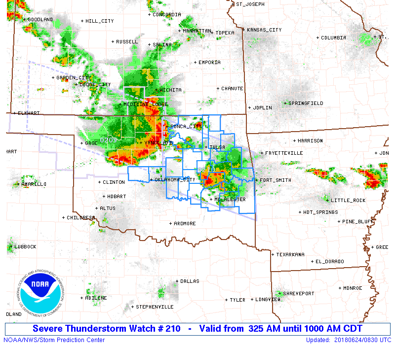
Severe Thunderstorm Watch Number 210
NWS Storm Prediction Center Norman OK
325 AM CDT Sun Jun 24 2018
The NWS Storm Prediction Center has issued a
* Severe Thunderstorm Watch for portions of
North-central and Eastern Oklahoma
* Effective this Sunday morning from 325 AM until 1000 AM CDT.
* Primary threats include...
Scattered damaging winds and isolated significant gusts to 75
mph possible
Isolated large hail events to 1.5 inches in diameter possible
A tornado or two possible
SUMMARY...A well-organized and intense convective line, with history
of measured 65+ mph wind gusts, will continue generally
southeastward across north-central and eastern Oklahoma through the
early morning hours. Pockets of wind damage can be expected along
with a few instances of hail. A brief line-embedded tornado cannot
be entirely ruled out.
The severe thunderstorm watch area is approximately along and 60
statute miles north and south of a line from 15 miles northeast of
Poteau OK to 35 miles northwest of Chandler OK. For a complete
depiction of the watch see the associated watch outline update
(WOUS64 KWNS WOU0).
PRECAUTIONARY/PREPAREDNESS ACTIONS...
REMEMBER...A Severe Thunderstorm Watch means conditions are
favorable for severe thunderstorms in and close to the watch area.
Persons in these areas should be on the lookout for threatening
weather conditions and listen for later statements and possible
warnings. Severe thunderstorms can and occasionally do produce
tornadoes.
&&
OTHER WATCH INFORMATION...CONTINUE...WW 209...
AVIATION...A few severe thunderstorms with hail surface and aloft to
1.5 inches. Extreme turbulence and surface wind gusts to 65 knots. A
few cumulonimbi with maximum tops to 550. Mean storm motion vector
30040.
...Guyer
 Note:
The Aviation Watch (SAW) product is an approximation to the watch area.
The actual watch is depicted by the shaded areas.
Note:
The Aviation Watch (SAW) product is an approximation to the watch area.
The actual watch is depicted by the shaded areas.
SAW0
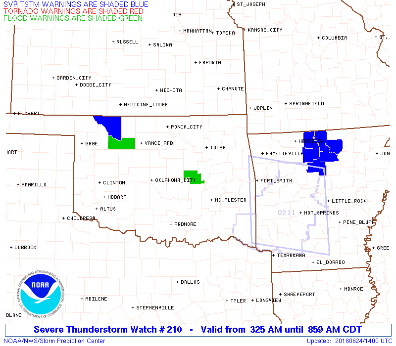
WW 210 SEVERE TSTM OK 240825Z - 241500Z
AXIS..60 STATUTE MILES NORTH AND SOUTH OF LINE..
15NE RKR/POTEAU OK/ - 35NW CQB/CHANDLER OK/
..AVIATION COORDS.. 50NM N/S /15SSW FSM - 36ESE END/
HAIL SURFACE AND ALOFT..1.5 INCHES. WIND GUSTS..65 KNOTS.
MAX TOPS TO 550. MEAN STORM MOTION VECTOR 30040.
LAT...LON 34319443 35209726 36959726 36049443
THIS IS AN APPROXIMATION TO THE WATCH AREA. FOR A
COMPLETE DEPICTION OF THE WATCH SEE WOUS64 KWNS
FOR WOU0.
Watch 210 Status Report Messages:
STATUS REPORT #4 ON WW 210
VALID 241130Z - 241240Z
SEVERE WEATHER THREAT CONTINUES RIGHT OF A LINE FROM 35 ESE OKC
TO 35 SE CQB TO 30 W MKO TO 15 SSE TUL TO 20 SSE BVO TO 15 N BVO
AND 10 SW MLC TO 30 ENE MLC TO 25 WNW FYV.
..MARSH..06/24/18
ATTN...WFO...OUN...TSA...
&&
STATUS REPORT FOR WS 210
SEVERE WEATHER THREAT CONTINUES FOR THE FOLLOWING AREAS
OKC077-079-135-241240-
OK
. OKLAHOMA COUNTIES INCLUDED ARE
LATIMER LE FLORE SEQUOYAH
$$
THE WATCH STATUS MESSAGE IS FOR GUIDANCE PURPOSES ONLY. PLEASE
REFER TO WATCH COUNTY NOTIFICATION STATEMENTS FOR OFFICIAL
INFORMATION ON COUNTIES...INDEPENDENT CITIES AND MARINE ZONES
CLEARED FROM SEVERE THUNDERSTORM AND TORNADO WATCHES.
$$
STATUS REPORT #3 ON WW 210
VALID 241130Z - 241240Z
SEVERE WEATHER THREAT CONTINUES RIGHT OF A LINE FROM 35 ESE OKC
TO 35 SE CQB TO 30 W MKO TO 15 SSE TUL TO 20 SSE BVO TO 15 N BVO
AND 10 SW MLC TO 30 ENE MLC TO 25 WNW FYV.
..MARSH..06/24/18
ATTN...WFO...OUN...TSA...
&&
STATUS REPORT FOR WS 210
SEVERE WEATHER THREAT CONTINUES FOR THE FOLLOWING AREAS
OKC077-079-135-241240-
OK
. OKLAHOMA COUNTIES INCLUDED ARE
LATIMER LE FLORE SEQUOYAH
$$
THE WATCH STATUS MESSAGE IS FOR GUIDANCE PURPOSES ONLY. PLEASE
REFER TO WATCH COUNTY NOTIFICATION STATEMENTS FOR OFFICIAL
INFORMATION ON COUNTIES...INDEPENDENT CITIES AND MARINE ZONES
CLEARED FROM SEVERE THUNDERSTORM AND TORNADO WATCHES.
$$
STATUS REPORT #2 ON WW 210
VALID 241025Z - 241140Z
SEVERE WEATHER THREAT CONTINUES RIGHT OF A LINE FROM 35 ESE OKC
TO 35 SE CQB TO 30 W MKO TO 15 SSE TUL TO 20 SSE BVO TO 15 N BVO.
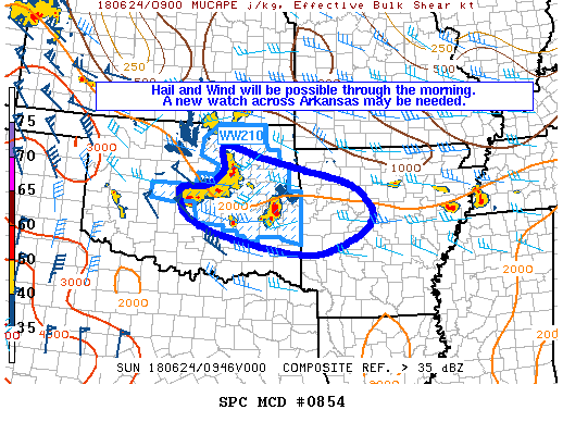
FOR ADDITIONAL INFORMATION SEE MESOSCALE DISCUSSION 854.
..MARSH..06/24/18
ATTN...WFO...OUN...TSA...
&&
STATUS REPORT FOR WS 210
SEVERE WEATHER THREAT CONTINUES FOR THE FOLLOWING AREAS
OKC021-061-063-077-079-091-097-101-105-121-131-135-145-241140-
OK
. OKLAHOMA COUNTIES INCLUDED ARE
CHEROKEE HASKELL HUGHES
LATIMER LE FLORE MCINTOSH
MAYES MUSKOGEE NOWATA
PITTSBURG ROGERS SEQUOYAH
WAGONER
$$
THE WATCH STATUS MESSAGE IS FOR GUIDANCE PURPOSES ONLY. PLEASE
REFER TO WATCH COUNTY NOTIFICATION STATEMENTS FOR OFFICIAL
INFORMATION ON COUNTIES...INDEPENDENT CITIES AND MARINE ZONES
CLEARED FROM SEVERE THUNDERSTORM AND TORNADO WATCHES.
$$
STATUS REPORT #1 ON WW 210
VALID 240940Z - 241040Z
SEVERE WEATHER THREAT CONTINUES RIGHT OF A LINE FROM 25 WNW CQB
TO 10 N CQB TO 40 W TUL TO 15 ESE PNC TO 10 N PNC.
..MARSH..06/24/18
ATTN...WFO...OUN...TSA...
&&
STATUS REPORT FOR WS 210
SEVERE WEATHER THREAT CONTINUES FOR THE FOLLOWING AREAS
OKC021-037-061-063-077-079-081-091-097-101-105-107-109-111-113-
117-121-125-131-133-135-143-145-147-241040-
OK
. OKLAHOMA COUNTIES INCLUDED ARE
CHEROKEE CREEK HASKELL
HUGHES LATIMER LE FLORE
LINCOLN MCINTOSH MAYES
MUSKOGEE NOWATA OKFUSKEE
OKLAHOMA OKMULGEE OSAGE
PAWNEE PITTSBURG POTTAWATOMIE
ROGERS SEMINOLE SEQUOYAH
TULSA WAGONER WASHINGTON
$$
THE WATCH STATUS MESSAGE IS FOR GUIDANCE PURPOSES ONLY. PLEASE
REFER TO WATCH COUNTY NOTIFICATION STATEMENTS FOR OFFICIAL
INFORMATION ON COUNTIES...INDEPENDENT CITIES AND MARINE ZONES
CLEARED FROM SEVERE THUNDERSTORM AND TORNADO WATCHES.
$$
Note:
Click for Complete Product Text.
Tornadoes
Probability of 2 or more tornadoes
|
Low (20%)
|
Probability of 1 or more strong (F2-F5) tornadoes
|
Low (<2%)
|
Wind
Probability of 10 or more severe wind events
|
Mod (50%)
|
Probability of 1 or more wind events > 65 knots
|
Mod (30%)
|
Hail
Probability of 10 or more severe hail events
|
Low (20%)
|
Probability of 1 or more hailstones > 2 inches
|
Low (10%)
|
Combined Severe Hail/Wind
Probability of 6 or more combined severe hail/wind events
|
High (80%)
|
For each watch, probabilities for particular events inside the watch
(listed above in each table) are determined by the issuing forecaster.
The "Low" category contains probability values ranging from less than 2%
to 20% (F2-F5 tornadoes), less than 5% to 20% (all other probabilities),
"Moderate" from 30% to 60%, and "High" from 70% to greater than 95%.
High values are bolded and lighter in color to provide awareness of
an increased threat for a particular event.


 @NWSSPC