 Note:
The expiration time in the watch graphic is amended if the watch is
replaced, cancelled or extended.
Note:
Note:
The expiration time in the watch graphic is amended if the watch is
replaced, cancelled or extended.
Note: Click for
Watch Status Reports.
SEL3
URGENT - IMMEDIATE BROADCAST REQUESTED
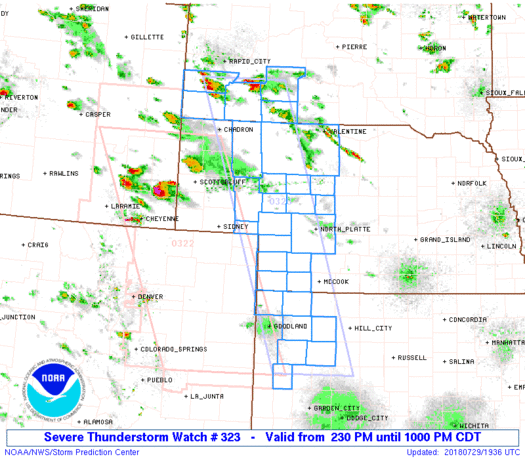
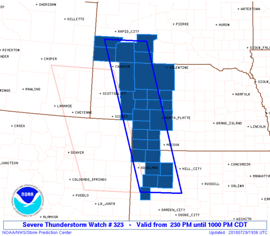
Severe Thunderstorm Watch Number 323
NWS Storm Prediction Center Norman OK
230 PM CDT Sun Jul 29 2018
The NWS Storm Prediction Center has issued a
* Severe Thunderstorm Watch for portions of
Northwest Kansas
Western Nebraska
Southwest South Dakota
* Effective this Sunday afternoon and evening from 230 PM until
1000 PM CDT.
* Primary threats include...
Scattered large hail and isolated very large hail events to 3
inches in diameter possible
Isolated significant damaging wind gusts to 75 mph possible
A tornado or two possible
SUMMARY...A couple supercells should develop southeast off the Black
Hills with an additional cluster of embedded supercells eventually
evolving from southeast Wyoming and northeast Colorado into
southwest Nebraska and northwest Kansas.
The severe thunderstorm watch area is approximately along and 50
statute miles east and west of a line from 70 miles north northeast
of Chadron NE to 80 miles southeast of Goodland KS. For a complete
depiction of the watch see the associated watch outline update
(WOUS64 KWNS WOU3).
PRECAUTIONARY/PREPAREDNESS ACTIONS...
REMEMBER...A Severe Thunderstorm Watch means conditions are
favorable for severe thunderstorms in and close to the watch area.
Persons in these areas should be on the lookout for threatening
weather conditions and listen for later statements and possible
warnings. Severe thunderstorms can and occasionally do produce
tornadoes.
&&
OTHER WATCH INFORMATION...CONTINUE...WW 322...
AVIATION...A few severe thunderstorms with hail surface and aloft to
3 inches. Extreme turbulence and surface wind gusts to 65 knots. A
few cumulonimbi with maximum tops to 500. Mean storm motion vector
32030.
...Grams
 Note:
The Aviation Watch (SAW) product is an approximation to the watch area.
The actual watch is depicted by the shaded areas.
Note:
The Aviation Watch (SAW) product is an approximation to the watch area.
The actual watch is depicted by the shaded areas.
   SAW3
   WW 323 SEVERE TSTM KS NE SD 291930Z - 300300Z
   AXIS..50 STATUTE MILES EAST AND WEST OF LINE..
   70NNE CDR/CHADRON NE/ - 80SE GLD/GOODLAND KS/
   ..AVIATION COORDS.. 45NM E/W /23ESE RAP - 37N GCK/
   HAIL SURFACE AND ALOFT..3 INCHES. WIND GUSTS..65 KNOTS.
   MAX TOPS TO 500. MEAN STORM MOTION VECTOR 32030.

   LAT...LON 43750155 38529973 38520158 43750356

   THIS IS AN APPROXIMATION TO THE WATCH AREA.  FOR A
   COMPLETE DEPICTION OF THE WATCH SEE WOUS64 KWNS
   FOR WOU3.
Watch 323 Status Report Messages:
STATUS REPORT #7 ON WW 323

VALID 300240Z - 300300Z

SEVERE WEATHER THREAT CONTINUES RIGHT OF A LINE FROM 50 SW IML TO
20 S IML TO 30 SW LBF TO 15 N LBF TO 15 WSW BUB AND 40 S GLD TO
45 S HLC TO 25 SSE LBF TO 30 SW BBW.

WW 323 WILL BE ALLOWED TO EXPIRE AT 300300Z.

..COOK..07/30/18

ATTN...WFO...GLD...LBF...UNR...

&&

STATUS REPORT FOR WS 323

SEVERE WEATHER THREAT CONTINUES FOR THE FOLLOWING AREAS

KSC203-300300-

KS
.    KANSAS COUNTIES INCLUDED ARE

WICHITA
$$


THE WATCH STATUS MESSAGE IS FOR GUIDANCE PURPOSES ONLY.  PLEASE
REFER TO WATCH COUNTY NOTIFICATION STATEMENTS FOR OFFICIAL
INFORMATION ON COUNTIES...INDEPENDENT CITIES AND MARINE ZONES
CLEARED FROM SEVERE THUNDERSTORM AND TORNADO WATCHES.
$$

STATUS REPORT #6 ON WW 323

VALID 300135Z - 300240Z

SEVERE WEATHER THREAT CONTINUES RIGHT OF A LINE FROM 50 SW IML TO
20 S IML TO 30 SW LBF TO 15 N LBF TO 15 WSW BUB.

..COOK..07/30/18

ATTN...WFO...GLD...LBF...UNR...

&&

STATUS REPORT FOR WS 323

SEVERE WEATHER THREAT CONTINUES FOR THE FOLLOWING AREAS

KSC023-063-109-153-179-193-203-300240-

KS
.    KANSAS COUNTIES INCLUDED ARE

CHEYENNE	     GOVE		 LOGAN
RAWLINS 	     SHERIDAN		 THOMAS
WICHITA
$$


NEC057-085-087-111-300240-

NE
.    NEBRASKA COUNTIES INCLUDED ARE

DUNDY		     HAYES		 HITCHCOCK
LINCOLN
$$


THE WATCH STATUS MESSAGE IS FOR GUIDANCE PURPOSES ONLY.  PLEASE
REFER TO WATCH COUNTY NOTIFICATION STATEMENTS FOR OFFICIAL
INFORMATION ON COUNTIES...INDEPENDENT CITIES AND MARINE ZONES
CLEARED FROM SEVERE THUNDERSTORM AND TORNADO WATCHES.
$$

STATUS REPORT #5 ON WW 323

VALID 300035Z - 300140Z

THE SEVERE WEATHER THREAT CONTINUES ACROSS THE ENTIRE WATCH AREA.

..COOK..07/30/18

ATTN...WFO...GLD...LBF...UNR...

&&

STATUS REPORT FOR WS 323

SEVERE WEATHER THREAT CONTINUES FOR THE FOLLOWING AREAS

KSC023-063-109-153-179-193-203-300140-

KS
.    KANSAS COUNTIES INCLUDED ARE

CHEYENNE	     GOVE		 LOGAN
RAWLINS 	     SHERIDAN		 THOMAS
WICHITA
$$


NEC005-029-031-049-057-069-075-085-087-091-101-111-113-117-135-
161-171-300140-

NE
.    NEBRASKA COUNTIES INCLUDED ARE

ARTHUR		     CHASE		 CHERRY
DEUEL		     DUNDY		 GARDEN
GRANT		     HAYES		 HITCHCOCK
HOOKER		     KEITH		 LINCOLN
LOGAN		     MCPHERSON		 PERKINS
SHERIDAN	     THOMAS
$$


SDC007-033-047-071-102-300140-

SD
.    SOUTH DAKOTA COUNTIES INCLUDED ARE

BENNETT 	     CUSTER		 FALL RIVER
JACKSON 	     OGLALA LAKOTA
$$


THE WATCH STATUS MESSAGE IS FOR GUIDANCE PURPOSES ONLY.  PLEASE
REFER TO WATCH COUNTY NOTIFICATION STATEMENTS FOR OFFICIAL
INFORMATION ON COUNTIES...INDEPENDENT CITIES AND MARINE ZONES
CLEARED FROM SEVERE THUNDERSTORM AND TORNADO WATCHES.
$$

STATUS REPORT #4 ON WW 323

VALID 292330Z - 300040Z

THE SEVERE WEATHER THREAT CONTINUES ACROSS THE ENTIRE WATCH AREA.

..COOK..07/29/18

ATTN...WFO...GLD...LBF...UNR...

&&

STATUS REPORT FOR WS 323

SEVERE WEATHER THREAT CONTINUES FOR THE FOLLOWING AREAS

KSC023-063-109-153-179-193-203-300040-

KS
.    KANSAS COUNTIES INCLUDED ARE

CHEYENNE	     GOVE		 LOGAN
RAWLINS 	     SHERIDAN		 THOMAS
WICHITA
$$


NEC005-029-031-049-057-069-075-085-087-091-101-111-113-117-135-
161-171-300040-

NE
.    NEBRASKA COUNTIES INCLUDED ARE

ARTHUR		     CHASE		 CHERRY
DEUEL		     DUNDY		 GARDEN
GRANT		     HAYES		 HITCHCOCK
HOOKER		     KEITH		 LINCOLN
LOGAN		     MCPHERSON		 PERKINS
SHERIDAN	     THOMAS
$$


SDC007-033-047-071-102-300040-

SD
.    SOUTH DAKOTA COUNTIES INCLUDED ARE

BENNETT 	     CUSTER		 FALL RIVER
JACKSON 	     OGLALA LAKOTA
$$


THE WATCH STATUS MESSAGE IS FOR GUIDANCE PURPOSES ONLY.  PLEASE
REFER TO WATCH COUNTY NOTIFICATION STATEMENTS FOR OFFICIAL
INFORMATION ON COUNTIES...INDEPENDENT CITIES AND MARINE ZONES
CLEARED FROM SEVERE THUNDERSTORM AND TORNADO WATCHES.
$$

STATUS REPORT #3 ON WW 323

VALID 292240Z - 292340Z

THE SEVERE WEATHER THREAT CONTINUES ACROSS THE ENTIRE WATCH AREA.

FOR ADDITIONAL INFORMATION SEE MESOSCALE DISCUSSION 1198

..COOK..07/29/18

ATTN...WFO...GLD...LBF...UNR...

&&

STATUS REPORT FOR WS 323

SEVERE WEATHER THREAT CONTINUES FOR THE FOLLOWING AREAS

KSC023-063-109-153-179-193-203-292340-

KS
.    KANSAS COUNTIES INCLUDED ARE

CHEYENNE	     GOVE		 LOGAN
RAWLINS 	     SHERIDAN		 THOMAS
WICHITA
$$


NEC005-029-031-049-057-069-075-085-087-091-101-111-113-117-135-
161-171-292340-

NE
.    NEBRASKA COUNTIES INCLUDED ARE

ARTHUR		     CHASE		 CHERRY
DEUEL		     DUNDY		 GARDEN
GRANT		     HAYES		 HITCHCOCK
HOOKER		     KEITH		 LINCOLN
LOGAN		     MCPHERSON		 PERKINS
SHERIDAN	     THOMAS
$$


SDC007-033-047-071-102-292340-

SD
.    SOUTH DAKOTA COUNTIES INCLUDED ARE

BENNETT 	     CUSTER		 FALL RIVER
JACKSON 	     OGLALA LAKOTA
$$


THE WATCH STATUS MESSAGE IS FOR GUIDANCE PURPOSES ONLY.  PLEASE
REFER TO WATCH COUNTY NOTIFICATION STATEMENTS FOR OFFICIAL
INFORMATION ON COUNTIES...INDEPENDENT CITIES AND MARINE ZONES
CLEARED FROM SEVERE THUNDERSTORM AND TORNADO WATCHES.
$$

STATUS REPORT #2 ON WW 323

VALID 292130Z - 292240Z

THE SEVERE WEATHER THREAT CONTINUES ACROSS THE ENTIRE WATCH AREA.

..COOK..07/29/18

ATTN...WFO...GLD...LBF...UNR...

&&

STATUS REPORT FOR WS 323

SEVERE WEATHER THREAT CONTINUES FOR THE FOLLOWING AREAS

KSC023-063-109-153-179-193-203-292240-

KS
.    KANSAS COUNTIES INCLUDED ARE

CHEYENNE	     GOVE		 LOGAN
RAWLINS 	     SHERIDAN		 THOMAS
WICHITA
$$


NEC005-029-031-049-057-069-075-085-087-091-101-111-113-117-135-
161-171-292240-

NE
.    NEBRASKA COUNTIES INCLUDED ARE

ARTHUR		     CHASE		 CHERRY
DEUEL		     DUNDY		 GARDEN
GRANT		     HAYES		 HITCHCOCK
HOOKER		     KEITH		 LINCOLN
LOGAN		     MCPHERSON		 PERKINS
SHERIDAN	     THOMAS
$$


SDC007-033-047-071-102-292240-

SD
.    SOUTH DAKOTA COUNTIES INCLUDED ARE

BENNETT 	     CUSTER		 FALL RIVER
JACKSON 	     OGLALA LAKOTA
$$


THE WATCH STATUS MESSAGE IS FOR GUIDANCE PURPOSES ONLY.  PLEASE
REFER TO WATCH COUNTY NOTIFICATION STATEMENTS FOR OFFICIAL
INFORMATION ON COUNTIES...INDEPENDENT CITIES AND MARINE ZONES
CLEARED FROM SEVERE THUNDERSTORM AND TORNADO WATCHES.
$$

STATUS REPORT #1 ON WW 323

VALID 292035Z - 292140Z

THE SEVERE WEATHER THREAT CONTINUES ACROSS THE ENTIRE WATCH AREA.

..SMITH..07/29/18

ATTN...WFO...GLD...LBF...UNR...

&&

STATUS REPORT FOR WS 323

SEVERE WEATHER THREAT CONTINUES FOR THE FOLLOWING AREAS

KSC023-063-109-153-179-193-203-292140-

KS
.    KANSAS COUNTIES INCLUDED ARE

CHEYENNE	     GOVE		 LOGAN
RAWLINS 	     SHERIDAN		 THOMAS
WICHITA
$$


NEC005-029-031-049-057-069-075-085-087-091-101-111-113-117-135-
161-171-292140-

NE
.    NEBRASKA COUNTIES INCLUDED ARE

ARTHUR		     CHASE		 CHERRY
DEUEL		     DUNDY		 GARDEN
GRANT		     HAYES		 HITCHCOCK
HOOKER		     KEITH		 LINCOLN
LOGAN		     MCPHERSON		 PERKINS
SHERIDAN	     THOMAS
$$


SDC007-033-047-071-102-292140-

SD
.    SOUTH DAKOTA COUNTIES INCLUDED ARE

BENNETT 	     CUSTER		 FALL RIVER
JACKSON 	     OGLALA LAKOTA
$$


THE WATCH STATUS MESSAGE IS FOR GUIDANCE PURPOSES ONLY.  PLEASE
REFER TO WATCH COUNTY NOTIFICATION STATEMENTS FOR OFFICIAL
INFORMATION ON COUNTIES...INDEPENDENT CITIES AND MARINE ZONES
CLEARED FROM SEVERE THUNDERSTORM AND TORNADO WATCHES.
$$
Note:
Click for Complete Product Text.
Tornadoes
Probability of 2 or more tornadoes
|
Low (20%)
|
Probability of 1 or more strong (EF2-EF5) tornadoes
|
Low (10%)
|
Wind
Probability of 10 or more severe wind events
|
Mod (30%)
|
Probability of 1 or more wind events > 65 knots
|
Mod (30%)
|
Hail
Probability of 10 or more severe hail events
|
Mod (50%)
|
Probability of 1 or more hailstones > 2 inches
|
Mod (40%)
|
Combined Severe Hail/Wind
Probability of 6 or more combined severe hail/wind events
|
High (70%)
|
For each watch, probabilities for particular events inside the watch
(listed above in each table) are determined by the issuing forecaster.
The "Low" category contains probability values ranging from less than 2%
to 20% (EF2-EF5 tornadoes), less than 5% to 20% (all other probabilities),
"Moderate" from 30% to 60%, and "High" from 70% to greater than 95%.
High values are bolded and lighter in color to provide awareness of
an increased threat for a particular event.


 @NWSSPC


