 Note:
The expiration time in the watch graphic is amended if the watch is
replaced, cancelled or extended.
Note:
Note:
The expiration time in the watch graphic is amended if the watch is
replaced, cancelled or extended.
Note: Click for
Watch Status Reports.
SEL2
URGENT - IMMEDIATE BROADCAST REQUESTED
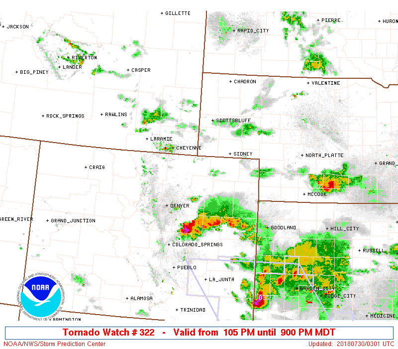
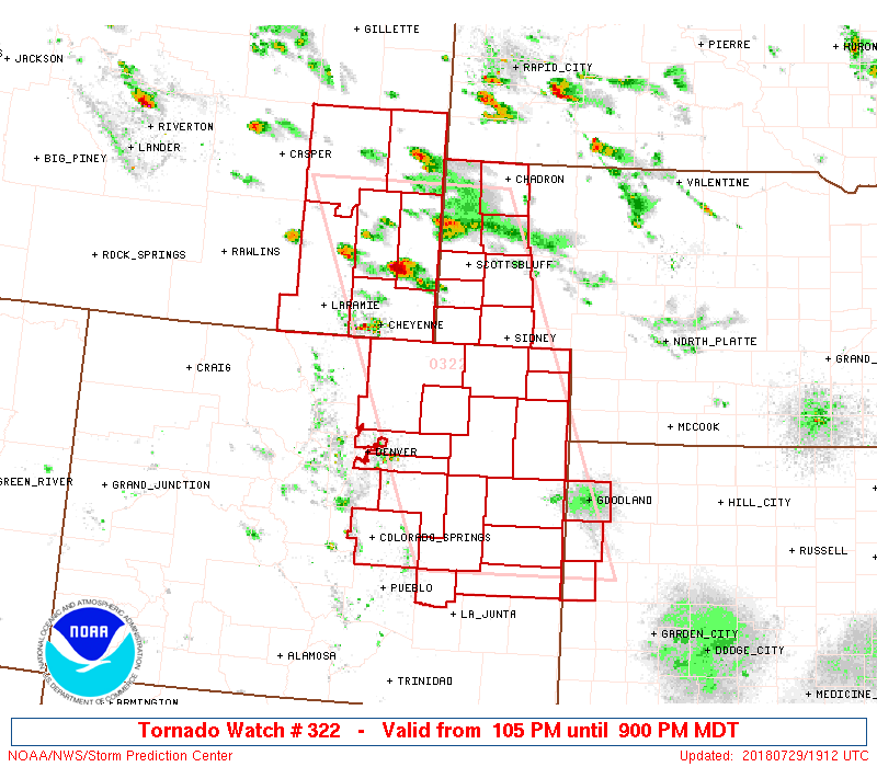
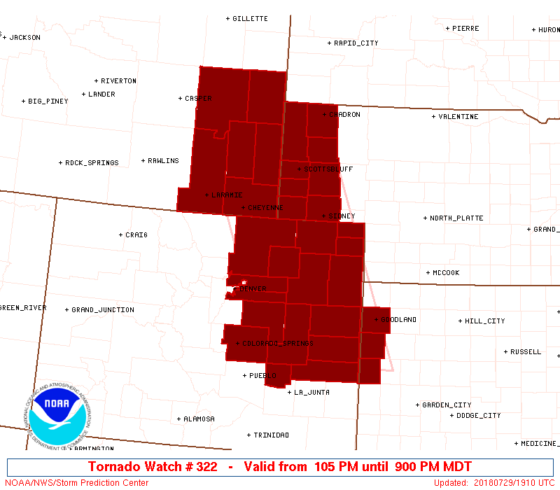
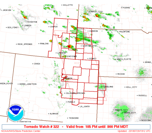
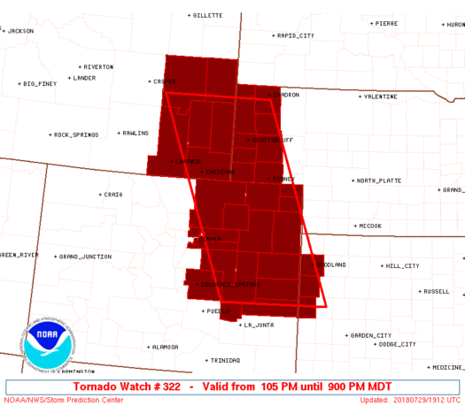
Tornado Watch Number 322
NWS Storm Prediction Center Norman OK
105 PM MDT Sun Jul 29 2018
The NWS Storm Prediction Center has issued a
* Tornado Watch for portions of
Eastern Colorado
Northwest Kansas
Nebraska Panhandle
Southeast Wyoming
* Effective this Sunday afternoon and evening from 105 PM until
900 PM MDT.
* Primary threats include...
A few tornadoes likely with a couple intense tornadoes possible
Scattered large hail and isolated very large hail events to 3.5
inches in diameter likely
Scattered damaging winds and isolated significant gusts to 80
mph possible
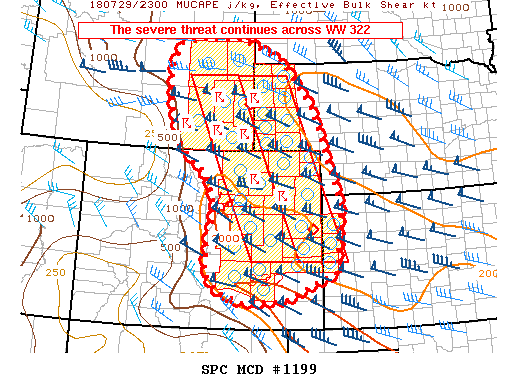
SUMMARY...Scattered discrete supercells should evolve southeast from
southeast Wyoming and may develop into a cluster near the
Colorado/Kansas border this evening. All hazards are anticipated.
The tornado watch area is approximately along and 75 statute miles
east and west of a line from 50 miles north northwest of Torrington
WY to 55 miles south southwest of Burlington CO. For a complete
depiction of the watch see the associated watch outline update
(WOUS64 KWNS WOU2).
PRECAUTIONARY/PREPAREDNESS ACTIONS...
REMEMBER...A Tornado Watch means conditions are favorable for
tornadoes and severe thunderstorms in and close to the watch
area. Persons in these areas should be on the lookout for
threatening weather conditions and listen for later statements
and possible warnings.
&&
AVIATION...Tornadoes and a few severe thunderstorms with hail
surface and aloft to 3.5 inches. Extreme turbulence and surface wind
gusts to 70 knots. A few cumulonimbi with maximum tops to 550. Mean
storm motion vector 31035.
...Grams
 Note:
The Aviation Watch (SAW) product is an approximation to the watch area.
The actual watch is depicted by the shaded areas.
Note:
The Aviation Watch (SAW) product is an approximation to the watch area.
The actual watch is depicted by the shaded areas.
   SAW2
   WW 322 TORNADO CO KS NE WY 291905Z - 300300Z
   AXIS..75 STATUTE MILES EAST AND WEST OF LINE..
   50NNW TOR/TORRINGTON WY/ - 55SSW ITR/BURLINGTON CO/
   ..AVIATION COORDS.. 65NM E/W /69NW BFF - 18N LAA/
   HAIL SURFACE AND ALOFT..3.5 INCHES. WIND GUSTS..70 KNOTS.
   MAX TOPS TO 550. MEAN STORM MOTION VECTOR 31035.

   LAT...LON 42720305 38500127 38500405 42720600

   THIS IS AN APPROXIMATION TO THE WATCH AREA.  FOR A
   COMPLETE DEPICTION OF THE WATCH SEE WOUS64 KWNS
   FOR WOU2.
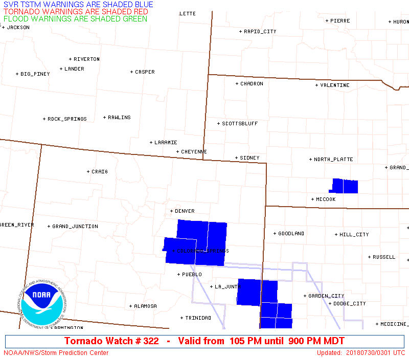
Watch 322 Status Report Messages:
STATUS REPORT #7 ON WW 322

VALID 300240Z - 300340Z

SEVERE WEATHER THREAT CONTINUES RIGHT OF A LINE FROM 5 WSW DEN TO
30 SW AKO TO 25 N ITR TO 15 N GLD.

..COOK..07/30/18

ATTN...WFO...BOU...GLD...PUB...CYS...

&&

STATUS REPORT FOR WT 322

SEVERE WEATHER THREAT CONTINUES FOR THE FOLLOWING AREAS

COC001-005-017-039-063-073-121-300340-

CO
.    COLORADO COUNTIES INCLUDED ARE

ADAMS		     ARAPAHOE		 CHEYENNE
ELBERT		     KIT CARSON 	 LINCOLN
WASHINGTON
$$


KSC071-181-199-300340-

KS
.    KANSAS COUNTIES INCLUDED ARE

GREELEY 	     SHERMAN		 WALLACE
$$


THE WATCH STATUS MESSAGE IS FOR GUIDANCE PURPOSES ONLY.  PLEASE
REFER TO WATCH COUNTY NOTIFICATION STATEMENTS FOR OFFICIAL
INFORMATION ON COUNTIES...INDEPENDENT CITIES AND MARINE ZONES
CLEARED FROM SEVERE THUNDERSTORM AND TORNADO WATCHES.
$$

STATUS REPORT #6 ON WW 322

VALID 300135Z - 300240Z

SEVERE WEATHER THREAT CONTINUES RIGHT OF A LINE FROM 20 SSW CYS
TO 55 NW AKO TO 20 SW AKO TO 15 N GLD.

..COOK..07/30/18

ATTN...WFO...BOU...GLD...PUB...CYS...

&&

STATUS REPORT FOR WT 322

SEVERE WEATHER THREAT CONTINUES FOR THE FOLLOWING AREAS

COC001-005-017-039-063-073-087-121-123-300240-

CO
.    COLORADO COUNTIES INCLUDED ARE

ADAMS		     ARAPAHOE		 CHEYENNE
ELBERT		     KIT CARSON 	 LINCOLN
MORGAN		     WASHINGTON 	 WELD
$$


KSC071-181-199-300240-

KS
.    KANSAS COUNTIES INCLUDED ARE

GREELEY 	     SHERMAN		 WALLACE
$$


THE WATCH STATUS MESSAGE IS FOR GUIDANCE PURPOSES ONLY.  PLEASE
REFER TO WATCH COUNTY NOTIFICATION STATEMENTS FOR OFFICIAL
INFORMATION ON COUNTIES...INDEPENDENT CITIES AND MARINE ZONES
CLEARED FROM SEVERE THUNDERSTORM AND TORNADO WATCHES.
$$

STATUS REPORT #5 ON WW 322

VALID 300040Z - 300140Z

THE SEVERE WEATHER THREAT CONTINUES ACROSS THE ENTIRE WATCH AREA.

..COOK..07/30/18

ATTN...WFO...BOU...GLD...PUB...CYS...

&&

STATUS REPORT FOR WT 322

SEVERE WEATHER THREAT CONTINUES FOR THE FOLLOWING AREAS

COC001-005-017-025-039-041-061-063-073-075-087-089-095-101-115-
121-123-125-300140-

CO
.    COLORADO COUNTIES INCLUDED ARE

ADAMS		     ARAPAHOE		 CHEYENNE
CROWLEY 	     ELBERT		 EL PASO
KIOWA		     KIT CARSON 	 LINCOLN
LOGAN		     MORGAN		 OTERO
PHILLIPS	     PUEBLO		 SEDGWICK
WASHINGTON	     WELD		 YUMA
$$


KSC071-181-199-300140-

KS
.    KANSAS COUNTIES INCLUDED ARE

GREELEY 	     SHERMAN		 WALLACE
$$


NEC007-013-033-045-105-123-157-165-300140-

NE
.    NEBRASKA COUNTIES INCLUDED ARE

BANNER		     BOX BUTTE		 CHEYENNE
DAWES		     KIMBALL		 MORRILL
SCOTTS BLUFF	     SIOUX
$$


WYC001-009-015-021-027-031-300140-

WY
.    WYOMING COUNTIES INCLUDED ARE

ALBANY		     CONVERSE		 GOSHEN
LARAMIE 	     NIOBRARA		 PLATTE
$$


THE WATCH STATUS MESSAGE IS FOR GUIDANCE PURPOSES ONLY.  PLEASE
REFER TO WATCH COUNTY NOTIFICATION STATEMENTS FOR OFFICIAL
INFORMATION ON COUNTIES...INDEPENDENT CITIES AND MARINE ZONES
CLEARED FROM SEVERE THUNDERSTORM AND TORNADO WATCHES.
$$

STATUS REPORT #4 ON WW 322

VALID 292325Z - 300040Z

THE SEVERE WEATHER THREAT CONTINUES ACROSS THE ENTIRE WATCH AREA.

FOR ADDITIONAL INFORMATION SEE MESOSCALE DISCUSSION 1199

..COOK..07/29/18

ATTN...WFO...BOU...GLD...PUB...CYS...

&&

STATUS REPORT FOR WT 322

SEVERE WEATHER THREAT CONTINUES FOR THE FOLLOWING AREAS

COC001-005-017-025-039-041-061-063-073-075-087-089-095-101-115-
121-123-125-300040-

CO
.    COLORADO COUNTIES INCLUDED ARE

ADAMS		     ARAPAHOE		 CHEYENNE
CROWLEY 	     ELBERT		 EL PASO
KIOWA		     KIT CARSON 	 LINCOLN
LOGAN		     MORGAN		 OTERO
PHILLIPS	     PUEBLO		 SEDGWICK
WASHINGTON	     WELD		 YUMA
$$


KSC071-181-199-300040-

KS
.    KANSAS COUNTIES INCLUDED ARE

GREELEY 	     SHERMAN		 WALLACE
$$


NEC007-013-033-045-105-123-157-165-300040-

NE
.    NEBRASKA COUNTIES INCLUDED ARE

BANNER		     BOX BUTTE		 CHEYENNE
DAWES		     KIMBALL		 MORRILL
SCOTTS BLUFF	     SIOUX
$$


WYC001-009-015-021-027-031-300040-

WY
.    WYOMING COUNTIES INCLUDED ARE

ALBANY		     CONVERSE		 GOSHEN
LARAMIE 	     NIOBRARA		 PLATTE
$$


THE WATCH STATUS MESSAGE IS FOR GUIDANCE PURPOSES ONLY.  PLEASE
REFER TO WATCH COUNTY NOTIFICATION STATEMENTS FOR OFFICIAL
INFORMATION ON COUNTIES...INDEPENDENT CITIES AND MARINE ZONES
CLEARED FROM SEVERE THUNDERSTORM AND TORNADO WATCHES.
$$

STATUS REPORT #3 ON WW 322

VALID 292240Z - 292340Z

THE SEVERE WEATHER THREAT CONTINUES ACROSS THE ENTIRE WATCH AREA.

..COOK..07/29/18

ATTN...WFO...BOU...GLD...PUB...CYS...

&&

STATUS REPORT FOR WT 322

SEVERE WEATHER THREAT CONTINUES FOR THE FOLLOWING AREAS

COC001-005-017-025-039-041-061-063-073-075-087-095-115-121-123-
125-292340-

CO
.    COLORADO COUNTIES INCLUDED ARE

ADAMS		     ARAPAHOE		 CHEYENNE
CROWLEY 	     ELBERT		 EL PASO
KIOWA		     KIT CARSON 	 LINCOLN
LOGAN		     MORGAN		 PHILLIPS
SEDGWICK	     WASHINGTON 	 WELD
YUMA
$$


KSC071-181-199-292340-

KS
.    KANSAS COUNTIES INCLUDED ARE

GREELEY 	     SHERMAN		 WALLACE
$$


NEC007-013-033-045-105-123-157-165-292340-

NE
.    NEBRASKA COUNTIES INCLUDED ARE

BANNER		     BOX BUTTE		 CHEYENNE
DAWES		     KIMBALL		 MORRILL
SCOTTS BLUFF	     SIOUX
$$


WYC001-009-015-021-027-031-292340-

WY
.    WYOMING COUNTIES INCLUDED ARE

ALBANY		     CONVERSE		 GOSHEN
LARAMIE 	     NIOBRARA		 PLATTE
$$


THE WATCH STATUS MESSAGE IS FOR GUIDANCE PURPOSES ONLY.  PLEASE
REFER TO WATCH COUNTY NOTIFICATION STATEMENTS FOR OFFICIAL
INFORMATION ON COUNTIES...INDEPENDENT CITIES AND MARINE ZONES
CLEARED FROM SEVERE THUNDERSTORM AND TORNADO WATCHES.
$$

STATUS REPORT #2 ON WW 322

VALID 292135Z - 292240Z

THE SEVERE WEATHER THREAT CONTINUES ACROSS THE ENTIRE WATCH AREA.

..COOK..07/29/18

ATTN...WFO...BOU...GLD...PUB...CYS...

&&

STATUS REPORT FOR WT 322

SEVERE WEATHER THREAT CONTINUES FOR THE FOLLOWING AREAS

COC001-005-017-025-039-041-061-063-073-075-087-095-115-121-123-
125-292240-

CO
.    COLORADO COUNTIES INCLUDED ARE

ADAMS		     ARAPAHOE		 CHEYENNE
CROWLEY 	     ELBERT		 EL PASO
KIOWA		     KIT CARSON 	 LINCOLN
LOGAN		     MORGAN		 PHILLIPS
SEDGWICK	     WASHINGTON 	 WELD
YUMA
$$


KSC071-181-199-292240-

KS
.    KANSAS COUNTIES INCLUDED ARE

GREELEY 	     SHERMAN		 WALLACE
$$


NEC007-013-033-045-105-123-157-165-292240-

NE
.    NEBRASKA COUNTIES INCLUDED ARE

BANNER		     BOX BUTTE		 CHEYENNE
DAWES		     KIMBALL		 MORRILL
SCOTTS BLUFF	     SIOUX
$$


WYC001-009-015-021-027-031-292240-

WY
.    WYOMING COUNTIES INCLUDED ARE

ALBANY		     CONVERSE		 GOSHEN
LARAMIE 	     NIOBRARA		 PLATTE
$$


THE WATCH STATUS MESSAGE IS FOR GUIDANCE PURPOSES ONLY.  PLEASE
REFER TO WATCH COUNTY NOTIFICATION STATEMENTS FOR OFFICIAL
INFORMATION ON COUNTIES...INDEPENDENT CITIES AND MARINE ZONES
CLEARED FROM SEVERE THUNDERSTORM AND TORNADO WATCHES.
$$

STATUS REPORT #1 ON WW 322

VALID 292035Z - 292140Z

THE SEVERE WEATHER THREAT CONTINUES ACROSS THE ENTIRE WATCH AREA.

FOR ADDITIONAL INFORMATION SEE MESOSCALE DISCUSSION 1196

..SMITH..07/29/18

ATTN...WFO...BOU...GLD...PUB...CYS...

&&

STATUS REPORT FOR WT 322

SEVERE WEATHER THREAT CONTINUES FOR THE FOLLOWING AREAS

COC001-005-017-025-039-041-061-063-073-075-087-095-115-121-123-
125-292140-

CO
.    COLORADO COUNTIES INCLUDED ARE

ADAMS		     ARAPAHOE		 CHEYENNE
CROWLEY 	     ELBERT		 EL PASO
KIOWA		     KIT CARSON 	 LINCOLN
LOGAN		     MORGAN		 PHILLIPS
SEDGWICK	     WASHINGTON 	 WELD
YUMA
$$


KSC071-181-199-292140-

KS
.    KANSAS COUNTIES INCLUDED ARE

GREELEY 	     SHERMAN		 WALLACE
$$


NEC007-013-033-045-105-123-157-165-292140-

NE
.    NEBRASKA COUNTIES INCLUDED ARE

BANNER		     BOX BUTTE		 CHEYENNE
DAWES		     KIMBALL		 MORRILL
SCOTTS BLUFF	     SIOUX
$$


WYC001-009-015-021-027-031-292140-

WY
.    WYOMING COUNTIES INCLUDED ARE

ALBANY		     CONVERSE		 GOSHEN
LARAMIE 	     NIOBRARA		 PLATTE
$$


THE WATCH STATUS MESSAGE IS FOR GUIDANCE PURPOSES ONLY.  PLEASE
REFER TO WATCH COUNTY NOTIFICATION STATEMENTS FOR OFFICIAL
INFORMATION ON COUNTIES...INDEPENDENT CITIES AND MARINE ZONES
CLEARED FROM SEVERE THUNDERSTORM AND TORNADO WATCHES.
$$
Note:
Click for Complete Product Text.
Tornadoes
Probability of 2 or more tornadoes
|
High (70%)
|
Probability of 1 or more strong (EF2-EF5) tornadoes
|
Mod (30%)
|
Wind
Probability of 10 or more severe wind events
|
Mod (50%)
|
Probability of 1 or more wind events > 65 knots
|
Mod (50%)
|
Hail
Probability of 10 or more severe hail events
|
Mod (60%)
|
Probability of 1 or more hailstones > 2 inches
|
Mod (60%)
|
Combined Severe Hail/Wind
Probability of 6 or more combined severe hail/wind events
|
High (90%)
|
For each watch, probabilities for particular events inside the watch
(listed above in each table) are determined by the issuing forecaster.
The "Low" category contains probability values ranging from less than 2%
to 20% (EF2-EF5 tornadoes), less than 5% to 20% (all other probabilities),
"Moderate" from 30% to 60%, and "High" from 70% to greater than 95%.
High values are bolded and lighter in color to provide awareness of
an increased threat for a particular event.


 @NWSSPC