 Note:
The expiration time in the watch graphic is amended if the watch is
replaced, cancelled or extended.
Note:
Note:
The expiration time in the watch graphic is amended if the watch is
replaced, cancelled or extended.
Note: Click for
Watch Status Reports.
SEL5
URGENT - IMMEDIATE BROADCAST REQUESTED
Severe Thunderstorm Watch Number 335
NWS Storm Prediction Center Norman OK
145 PM MDT Tue Aug 7 2018
The NWS Storm Prediction Center has issued a
* Severe Thunderstorm Watch for portions of
The central and southern Front Range of Colorado
Extreme northeastern New Mexico
* Effective this Tuesday afternoon and evening from 145 PM until
900 PM MDT.
* Primary threats include...
Scattered large hail and isolated very large hail events to 2.5
inches in diameter likely
Isolated damaging wind gusts to 70 mph possible
A tornado or two possible
SUMMARY...Thunderstorm development is expected by 21z along the
Front Range from Colorado Springs southward. The storm environment
will favor splitting supercells with very large hail and damaging
gusts, plus the potential for an isolated tornado. The severe-storm
threat should persist into the late evening hours as storms spread
southeastward onto the High Plains.
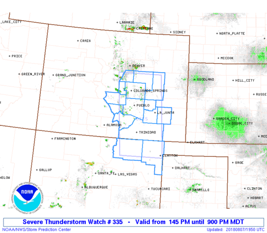
The severe thunderstorm watch area is approximately along and 55
statute miles east and west of a line from 40 miles west northwest
of Limon CO to 35 miles southeast of Raton NM. For a complete
depiction of the watch see the associated watch outline update
(WOUS64 KWNS WOU5).
PRECAUTIONARY/PREPAREDNESS ACTIONS...
REMEMBER...A Severe Thunderstorm Watch means conditions are
favorable for severe thunderstorms in and close to the watch area.
Persons in these areas should be on the lookout for threatening
weather conditions and listen for later statements and possible
warnings. Severe thunderstorms can and occasionally do produce
tornadoes.
&&
AVIATION...A few severe thunderstorms with hail surface and aloft to
2.5 inches. Extreme turbulence and surface wind gusts to 60 knots. A
few cumulonimbi with maximum tops to 550. Mean storm motion vector
31035.
...Thompson

   SEL5

   URGENT - IMMEDIATE BROADCAST REQUESTED
   Severe Thunderstorm Watch Number 335
   NWS Storm Prediction Center Norman OK
   145 PM MDT Tue Aug 7 2018

   The NWS Storm Prediction Center has issued a

   * Severe Thunderstorm Watch for portions of
     The central and southern Front Range of Colorado
     Extreme northeastern New Mexico

   * Effective this Tuesday afternoon and evening from 145 PM until
     900 PM MDT.

   * Primary threats include...
     Scattered large hail and isolated very large hail events to 2.5
       inches in diameter likely
     Isolated damaging wind gusts to 70 mph possible
     A tornado or two possible

   SUMMARY...Thunderstorm development is expected by 21z along the
   Front Range from Colorado Springs southward.  The storm environment
   will favor splitting supercells with very large hail and damaging
   gusts, plus the potential for an isolated tornado.  The severe-storm
   threat should persist into the late evening hours as storms spread
   southeastward onto the High Plains.

   The severe thunderstorm watch area is approximately along and 55
   statute miles east and west of a line from 40 miles west northwest
   of Limon CO to 35 miles southeast of Raton NM. For a complete
   depiction of the watch see the associated watch outline update
   (WOUS64 KWNS WOU5).

   PRECAUTIONARY/PREPAREDNESS ACTIONS...

   REMEMBER...A Severe Thunderstorm Watch means conditions are
   favorable for severe thunderstorms in and close to the watch area.
   Persons in these areas should be on the lookout for threatening
   weather conditions and listen for later statements and possible
   warnings. Severe thunderstorms can and occasionally do produce
   tornadoes.

   &&

   AVIATION...A few severe thunderstorms with hail surface and aloft to
   2.5 inches. Extreme turbulence and surface wind gusts to 60 knots. A
   few cumulonimbi with maximum tops to 550. Mean storm motion vector
   31035.

   ...Thompson
 Note:
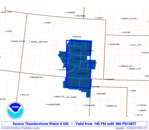
The Aviation Watch (SAW) product is an approximation to the watch area.
The actual watch is depicted by the shaded areas.
Note:
The Aviation Watch (SAW) product is an approximation to the watch area.
The actual watch is depicted by the shaded areas.
   SAW5
   WW 335 SEVERE TSTM CO NM 071945Z - 080300Z
   AXIS..55 STATUTE MILES EAST AND WEST OF LINE..
   40WNW LIC/LIMON CO/ - 35SE RTN/RATON NM/
   ..AVIATION COORDS.. 50NM E/W /24SE DEN - 40E CIM/
   HAIL SURFACE AND ALOFT..2.5 INCHES. WIND GUSTS..60 KNOTS.
   MAX TOPS TO 550. MEAN STORM MOTION VECTOR 31035.

   LAT...LON 39470333 36360306 36360504 39470538

   THIS IS AN APPROXIMATION TO THE WATCH AREA.  FOR A
   COMPLETE DEPICTION OF THE WATCH SEE WOUS64 KWNS
   FOR WOU5.
Watch 335 Status Report Messages:
STATUS REPORT #4 ON WW 335

VALID 080225Z - 080300Z

SEVERE WEATHER THREAT CONTINUES RIGHT OF A LINE FROM 30 NNE ALS
TO 25 SSE PUB TO 20 NNW SPD.

WW 335 WILL BE ALLOWED TO EXPIRE AT 080300Z.

FOR ADDITIONAL INFORMATION SEE MESOSCALE DISCUSSION 1260

..WENDT..08/08/18

ATTN...WFO...PUB...BOU...ABQ...

&&

STATUS REPORT FOR WS 335

SEVERE WEATHER THREAT CONTINUES FOR THE FOLLOWING AREAS

COC055-071-080300-

CO
.    COLORADO COUNTIES INCLUDED ARE

HUERFANO	     LAS ANIMAS
$$


NMC007-059-080300-

NM
.    NEW MEXICO COUNTIES INCLUDED ARE

COLFAX		     UNION
$$


THE WATCH STATUS MESSAGE IS FOR GUIDANCE PURPOSES ONLY.  PLEASE
REFER TO WATCH COUNTY NOTIFICATION STATEMENTS FOR OFFICIAL
INFORMATION ON COUNTIES...INDEPENDENT CITIES AND MARINE ZONES
CLEARED FROM SEVERE THUNDERSTORM AND TORNADO WATCHES.
$$

STATUS REPORT #3 ON WW 335

VALID 080025Z - 080140Z

SEVERE WEATHER THREAT CONTINUES RIGHT OF A LINE FROM 45 N ALS TO
25 WNW PUB TO 20 N PUB TO 25 NNE COS TO 20 SE DEN.

..WENDT..08/08/18

ATTN...WFO...PUB...BOU...ABQ...

&&

STATUS REPORT FOR WS 335

SEVERE WEATHER THREAT CONTINUES FOR THE FOLLOWING AREAS

COC011-025-027-039-055-071-073-089-101-080140-

CO
.    COLORADO COUNTIES INCLUDED ARE

BENT		     CROWLEY		 CUSTER
ELBERT		     HUERFANO		 LAS ANIMAS
LINCOLN 	     OTERO		 PUEBLO
$$


NMC007-059-080140-

NM
.    NEW MEXICO COUNTIES INCLUDED ARE

COLFAX		     UNION
$$


THE WATCH STATUS MESSAGE IS FOR GUIDANCE PURPOSES ONLY.  PLEASE
REFER TO WATCH COUNTY NOTIFICATION STATEMENTS FOR OFFICIAL
INFORMATION ON COUNTIES...INDEPENDENT CITIES AND MARINE ZONES
CLEARED FROM SEVERE THUNDERSTORM AND TORNADO WATCHES.
$$

STATUS REPORT #2 ON WW 335

VALID 072300Z - 080040Z

THE SEVERE WEATHER THREAT CONTINUES ACROSS THE ENTIRE WATCH AREA.

FOR ADDITIONAL INFORMATION SEE MESOSCALE DISCUSSION 1259

..WENDT..08/07/18

ATTN...WFO...PUB...BOU...ABQ...

&&

STATUS REPORT FOR WS 335

SEVERE WEATHER THREAT CONTINUES FOR THE FOLLOWING AREAS

COC011-025-027-035-039-041-043-055-071-073-089-101-119-080040-

CO
.    COLORADO COUNTIES INCLUDED ARE

BENT		     CROWLEY		 CUSTER
DOUGLAS 	     ELBERT		 EL PASO
FREMONT 	     HUERFANO		 LAS ANIMAS
LINCOLN 	     OTERO		 PUEBLO
TELLER
$$


NMC007-059-080040-

NM
.    NEW MEXICO COUNTIES INCLUDED ARE

COLFAX		     UNION
$$


THE WATCH STATUS MESSAGE IS FOR GUIDANCE PURPOSES ONLY.  PLEASE
REFER TO WATCH COUNTY NOTIFICATION STATEMENTS FOR OFFICIAL
INFORMATION ON COUNTIES...INDEPENDENT CITIES AND MARINE ZONES
CLEARED FROM SEVERE THUNDERSTORM AND TORNADO WATCHES.
$$

STATUS REPORT #1 ON WW 335

VALID 072145Z - 072240Z

THE SEVERE WEATHER THREAT CONTINUES ACROSS THE ENTIRE WATCH AREA.

..WENDT..08/07/18

ATTN...WFO...PUB...BOU...ABQ...

&&

STATUS REPORT FOR WS 335

SEVERE WEATHER THREAT CONTINUES FOR THE FOLLOWING AREAS

COC011-025-027-035-039-041-043-055-071-073-089-101-119-072240-

CO
.    COLORADO COUNTIES INCLUDED ARE

BENT		     CROWLEY		 CUSTER
DOUGLAS 	     ELBERT		 EL PASO
FREMONT 	     HUERFANO		 LAS ANIMAS
LINCOLN 	     OTERO		 PUEBLO
TELLER
$$


NMC007-059-072240-

NM
.    NEW MEXICO COUNTIES INCLUDED ARE

COLFAX		     UNION
$$


THE WATCH STATUS MESSAGE IS FOR GUIDANCE PURPOSES ONLY.  PLEASE
REFER TO WATCH COUNTY NOTIFICATION STATEMENTS FOR OFFICIAL
INFORMATION ON COUNTIES...INDEPENDENT CITIES AND MARINE ZONES
CLEARED FROM SEVERE THUNDERSTORM AND TORNADO WATCHES.
$$
Note:
Click for Complete Product Text.
Tornadoes
Probability of 2 or more tornadoes
|
Low (20%)
|
Probability of 1 or more strong (EF2-EF5) tornadoes
|
Low (<2%)
|
Wind
Probability of 10 or more severe wind events
|
Mod (30%)
|
Probability of 1 or more wind events > 65 knots
|
Low (10%)
|
Hail
Probability of 10 or more severe hail events
|
High (70%)
|
Probability of 1 or more hailstones > 2 inches
|
Mod (60%)
|
Combined Severe Hail/Wind
Probability of 6 or more combined severe hail/wind events
|
High (90%)
|
For each watch, probabilities for particular events inside the watch
(listed above in each table) are determined by the issuing forecaster.
The "Low" category contains probability values ranging from less than 2%
to 20% (EF2-EF5 tornadoes), less than 5% to 20% (all other probabilities),
"Moderate" from 30% to 60%, and "High" from 70% to greater than 95%.
High values are bolded and lighter in color to provide awareness of
an increased threat for a particular event.


 @NWSSPC


