Note:
The expiration time in the watch graphic is amended if the watch is
replaced, cancelled or extended.
Note:
Note:
The expiration time in the watch graphic is amended if the watch is
replaced, cancelled or extended.
Note: Click for
Watch Status Reports.
SEL6
URGENT - IMMEDIATE BROADCAST REQUESTED
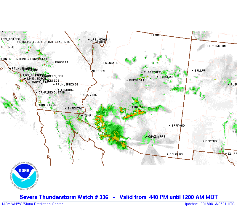
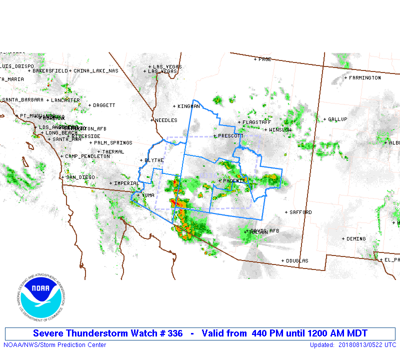
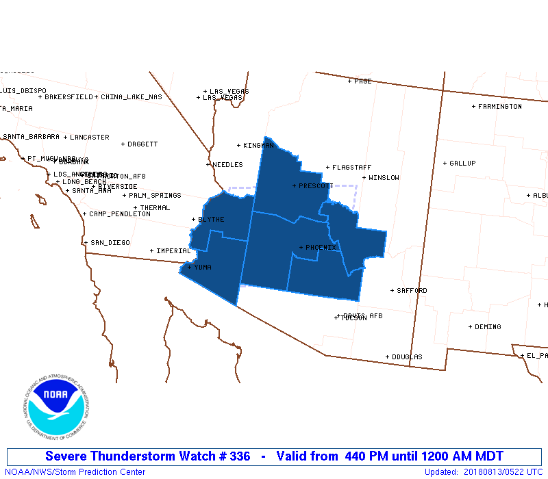
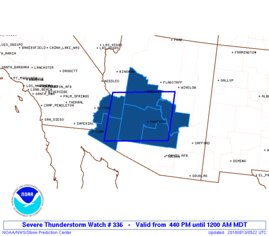
Severe Thunderstorm Watch Number 336
NWS Storm Prediction Center Norman OK
440 PM MDT Sun Aug 12 2018
The NWS Storm Prediction Center has issued a
* Severe Thunderstorm Watch for portions of
Central and southern Arizona
* Effective this Sunday afternoon from 440 PM until Midnight MDT.
* Primary threats include...
Scattered damaging winds and isolated significant gusts to 75
mph possible
SUMMARY...Storm clusters should develop west-southwest off the
Mogollon Rim across parts of the Gila Valley this evening,
potentially including the Phoenix metro area. Strong to severe wind
gusts are the main hazard.
The severe thunderstorm watch area is approximately along and 70
statute miles north and south of a line from 80 miles west northwest
of Gila Bend AZ to 70 miles east northeast of Phoenix AZ. For a
complete depiction of the watch see the associated watch outline
update (WOUS64 KWNS WOU6).
PRECAUTIONARY/PREPAREDNESS ACTIONS...
REMEMBER...A Severe Thunderstorm Watch means conditions are
favorable for severe thunderstorms in and close to the watch area.
Persons in these areas should be on the lookout for threatening
weather conditions and listen for later statements and possible
warnings. Severe thunderstorms can and occasionally do produce
tornadoes.
&&
AVIATION...A few severe thunderstorms with hail surface and aloft to
1.5 inches. Extreme turbulence and surface wind gusts to 65 knots. A
few cumulonimbi with maximum tops to 500. Mean storm motion vector
07025.
...Grams

   SEL6

   URGENT - IMMEDIATE BROADCAST REQUESTED
   Severe Thunderstorm Watch Number 336
   NWS Storm Prediction Center Norman OK
   440 PM MDT Sun Aug 12 2018

   The NWS Storm Prediction Center has issued a

   * Severe Thunderstorm Watch for portions of
     Central and southern Arizona

   * Effective this Sunday afternoon from 440 PM until Midnight MDT.

   * Primary threats include...
     Scattered damaging winds and isolated significant gusts to 75
       mph possible

   SUMMARY...Storm clusters should develop west-southwest off the
   Mogollon Rim across parts of the Gila Valley this evening,
   potentially including the Phoenix metro area. Strong to severe wind
   gusts are the main hazard.

   The severe thunderstorm watch area is approximately along and 70
   statute miles north and south of a line from 80 miles west northwest
   of Gila Bend AZ to 70 miles east northeast of Phoenix AZ. For a
   complete depiction of the watch see the associated watch outline
   update (WOUS64 KWNS WOU6).

   PRECAUTIONARY/PREPAREDNESS ACTIONS...

   REMEMBER...A Severe Thunderstorm Watch means conditions are
   favorable for severe thunderstorms in and close to the watch area.
   Persons in these areas should be on the lookout for threatening
   weather conditions and listen for later statements and possible
   warnings. Severe thunderstorms can and occasionally do produce
   tornadoes.

   &&

   AVIATION...A few severe thunderstorms with hail surface and aloft to
   1.5 inches. Extreme turbulence and surface wind gusts to 65 knots. A
   few cumulonimbi with maximum tops to 500. Mean storm motion vector
   07025.

   ...Grams
 Note:
The Aviation Watch (SAW) product is an approximation to the watch area.
The actual watch is depicted by the shaded areas.
Note:
The Aviation Watch (SAW) product is an approximation to the watch area.
The actual watch is depicted by the shaded areas.
   SAW6
   WW 336 SEVERE TSTM AZ 122240Z - 130600Z
   AXIS..70 STATUTE MILES NORTH AND SOUTH OF LINE..
   80WNW GBN/GILA BEND AZ/ - 70ENE PHX/PHOENIX AZ/
   ..AVIATION COORDS.. 60NM N/S /47NE BZA - 61ENE PHX/
   HAIL SURFACE AND ALOFT..1.5 INCHES. WIND GUSTS..65 KNOTS.
   MAX TOPS TO 500. MEAN STORM MOTION VECTOR 07025.

   LAT...LON 34381398 34831088 32791088 32341398

   THIS IS AN APPROXIMATION TO THE WATCH AREA.  FOR A
   COMPLETE DEPICTION OF THE WATCH SEE WOUS64 KWNS
   FOR WOU6.
Watch 336 Status Report Messages:
STATUS REPORT #4 ON WW 336

VALID 130545Z - 130640Z

SEVERE WEATHER THREAT CONTINUES RIGHT OF A LINE FROM 45 ESE BLH
TO 50 WNW GBN TO 40 SSW GBN.

..GOSS..08/13/18

ATTN...WFO...PSR...FGZ...

&&

STATUS REPORT FOR WS 336

SEVERE WEATHER THREAT CONTINUES FOR THE FOLLOWING AREAS

AZC013-027-130640-

AZ
.    ARIZONA COUNTIES INCLUDED ARE

MARICOPA	     YUMA
$$


THE WATCH STATUS MESSAGE IS FOR GUIDANCE PURPOSES ONLY.  PLEASE
REFER TO WATCH COUNTY NOTIFICATION STATEMENTS FOR OFFICIAL
INFORMATION ON COUNTIES...INDEPENDENT CITIES AND MARINE ZONES
CLEARED FROM SEVERE THUNDERSTORM AND TORNADO WATCHES.
$$

STATUS REPORT #3 ON WW 336

VALID 130430Z - 130540Z

SEVERE WEATHER THREAT CONTINUES RIGHT OF A LINE FROM 55 SSE IGM
TO 30 SE GBN.

..GRAMS..08/13/18

ATTN...WFO...PSR...FGZ...

&&

STATUS REPORT FOR WS 336

SEVERE WEATHER THREAT CONTINUES FOR THE FOLLOWING AREAS

AZC012-013-027-130540-

AZ
.    ARIZONA COUNTIES INCLUDED ARE

LA PAZ		     MARICOPA		 YUMA
$$


THE WATCH STATUS MESSAGE IS FOR GUIDANCE PURPOSES ONLY.  PLEASE
REFER TO WATCH COUNTY NOTIFICATION STATEMENTS FOR OFFICIAL
INFORMATION ON COUNTIES...INDEPENDENT CITIES AND MARINE ZONES
CLEARED FROM SEVERE THUNDERSTORM AND TORNADO WATCHES.
$$

STATUS REPORT #2 ON WW 336

VALID 130230Z - 130340Z

THE SEVERE WEATHER THREAT CONTINUES ACROSS THE ENTIRE WATCH AREA.

..PICCA..08/13/18

ATTN...WFO...PSR...FGZ...

&&

STATUS REPORT FOR WS 336

SEVERE WEATHER THREAT CONTINUES FOR THE FOLLOWING AREAS

AZC007-012-013-021-025-027-130340-

AZ
.    ARIZONA COUNTIES INCLUDED ARE

GILA		     LA PAZ		 MARICOPA
PINAL		     YAVAPAI		 YUMA
$$


THE WATCH STATUS MESSAGE IS FOR GUIDANCE PURPOSES ONLY.  PLEASE
REFER TO WATCH COUNTY NOTIFICATION STATEMENTS FOR OFFICIAL
INFORMATION ON COUNTIES...INDEPENDENT CITIES AND MARINE ZONES
CLEARED FROM SEVERE THUNDERSTORM AND TORNADO WATCHES.
$$

STATUS REPORT #1 ON WW 336

VALID 130025Z - 130140Z

THE SEVERE WEATHER THREAT CONTINUES ACROSS THE ENTIRE WATCH AREA.

..PICCA..08/13/18

ATTN...WFO...PSR...FGZ...

&&

STATUS REPORT FOR WS 336

SEVERE WEATHER THREAT CONTINUES FOR THE FOLLOWING AREAS

AZC007-012-013-021-025-027-130140-

AZ
.    ARIZONA COUNTIES INCLUDED ARE

GILA		     LA PAZ		 MARICOPA
PINAL		     YAVAPAI		 YUMA
$$


THE WATCH STATUS MESSAGE IS FOR GUIDANCE PURPOSES ONLY.  PLEASE
REFER TO WATCH COUNTY NOTIFICATION STATEMENTS FOR OFFICIAL
INFORMATION ON COUNTIES...INDEPENDENT CITIES AND MARINE ZONES
CLEARED FROM SEVERE THUNDERSTORM AND TORNADO WATCHES.
$$
Note:
Click for Complete Product Text.
Tornadoes
Probability of 2 or more tornadoes
|
Low (<5%)
|
Probability of 1 or more strong (EF2-EF5) tornadoes
|
Low (<2%)
|
Wind
Probability of 10 or more severe wind events
|
Mod (40%)
|
Probability of 1 or more wind events > 65 knots
|
Mod (30%)
|
Hail
Probability of 10 or more severe hail events
|
Low (10%)
|
Probability of 1 or more hailstones > 2 inches
|
Low (10%)
|
Combined Severe Hail/Wind
Probability of 6 or more combined severe hail/wind events
|
Mod (60%)
|
For each watch, probabilities for particular events inside the watch
(listed above in each table) are determined by the issuing forecaster.
The "Low" category contains probability values ranging from less than 2%
to 20% (EF2-EF5 tornadoes), less than 5% to 20% (all other probabilities),
"Moderate" from 30% to 60%, and "High" from 70% to greater than 95%.
High values are bolded and lighter in color to provide awareness of
an increased threat for a particular event.


 @NWSSPC