 Note:
The expiration time in the watch graphic is amended if the watch is
replaced, cancelled or extended.
Note:
Note:
The expiration time in the watch graphic is amended if the watch is
replaced, cancelled or extended.
Note: Click for
Watch Status Reports.
SEL7
URGENT - IMMEDIATE BROADCAST REQUESTED
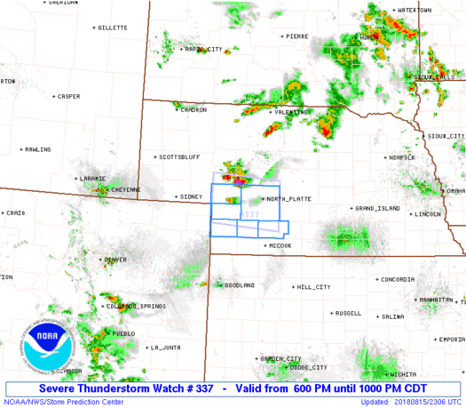
Severe Thunderstorm Watch Number 337
NWS Storm Prediction Center Norman OK
600 PM CDT Wed Aug 15 2018
The NWS Storm Prediction Center has issued a
* Severe Thunderstorm Watch for portions of
A small part of central and southwest Nebraska
* Effective this Wednesday evening from 600 PM until 1000 PM CDT.
* Primary threats include...
Scattered large hail and isolated very large hail events to 2
inches in diameter possible
Isolated damaging wind gusts to 70 mph possible
SUMMARY...A cluster of supercells along an outflow boundary should
persist through late evening while moving southeastward. The storm
environment will be sufficient to maintain the supercells with an
attendant threat for large hail and damaging winds.
The severe thunderstorm watch area is approximately along and 35
statute miles north and south of a line from 70 miles west of North
Platte NE to 25 miles east southeast of North Platte NE. For a
complete depiction of the watch see the associated watch outline
update (WOUS64 KWNS WOU7).
PRECAUTIONARY/PREPAREDNESS ACTIONS...
REMEMBER...A Severe Thunderstorm Watch means conditions are
favorable for severe thunderstorms in and close to the watch area.
Persons in these areas should be on the lookout for threatening
weather conditions and listen for later statements and possible
warnings. Severe thunderstorms can and occasionally do produce
tornadoes.
&&
AVIATION...A few severe thunderstorms with hail surface and aloft to
2 inches. Extreme turbulence and surface wind gusts to 60 knots. A
few cumulonimbi with maximum tops to 450. Mean storm motion vector
32020.
...Thompson
 Note:
The Aviation Watch (SAW) product is an approximation to the watch area.
The actual watch is depicted by the shaded areas.
Note:
The Aviation Watch (SAW) product is an approximation to the watch area.
The actual watch is depicted by the shaded areas.
   SAW7
   WW 337 SEVERE TSTM NE 152300Z - 160300Z
   AXIS..35 STATUTE MILES NORTH AND SOUTH OF LINE..
   70W LBF/NORTH PLATTE NE/ - 25ESE LBF/NORTH PLATTE NE/
   ..AVIATION COORDS.. 30NM N/S /43E SNY - 23ESE LBF/
   HAIL SURFACE AND ALOFT..2 INCHES. WIND GUSTS..60 KNOTS.
   MAX TOPS TO 450. MEAN STORM MOTION VECTOR 32020.

   LAT...LON 41630201 41500023 40470023 40610201

   THIS IS AN APPROXIMATION TO THE WATCH AREA.  FOR A
   COMPLETE DEPICTION OF THE WATCH SEE WOUS64 KWNS
   FOR WOU7.
Watch 337 Status Report Messages:
STATUS REPORT #3 ON WW 337

VALID 160225Z - 160300Z

WW 337 COULD BE CANCELLED EARLY, OR OTHERWISE MAY BE ALLOWED TO
EXPIRE AT 16/03Z.

..KERR..08/16/18

ATTN...WFO...LBF...

&&

STATUS REPORT FOR WS 337

SEVERE WEATHER THREAT CONTINUES FOR THE FOLLOWING AREAS

NEC029-063-085-101-111-135-160300-

NE
.    NEBRASKA COUNTIES INCLUDED ARE

CHASE		     FRONTIER		 HAYES
KEITH		     LINCOLN		 PERKINS
$$


THE WATCH STATUS MESSAGE IS FOR GUIDANCE PURPOSES ONLY.  PLEASE
REFER TO WATCH COUNTY NOTIFICATION STATEMENTS FOR OFFICIAL
INFORMATION ON COUNTIES...INDEPENDENT CITIES AND MARINE ZONES
CLEARED FROM SEVERE THUNDERSTORM AND TORNADO WATCHES.
$$

STATUS REPORT #2 ON WW 337

VALID 160125Z - 160240Z

THE SEVERE WEATHER THREAT CONTINUES ACROSS THE ENTIRE WATCH AREA.

..KERR..08/16/18

ATTN...WFO...LBF...

&&

STATUS REPORT FOR WS 337

SEVERE WEATHER THREAT CONTINUES FOR THE FOLLOWING AREAS

NEC029-063-085-101-111-135-160240-

NE
.    NEBRASKA COUNTIES INCLUDED ARE

CHASE		     FRONTIER		 HAYES
KEITH		     LINCOLN		 PERKINS
$$


THE WATCH STATUS MESSAGE IS FOR GUIDANCE PURPOSES ONLY.  PLEASE
REFER TO WATCH COUNTY NOTIFICATION STATEMENTS FOR OFFICIAL
INFORMATION ON COUNTIES...INDEPENDENT CITIES AND MARINE ZONES
CLEARED FROM SEVERE THUNDERSTORM AND TORNADO WATCHES.
$$

STATUS REPORT #1 ON WW 337

VALID 160025Z - 160140Z

THE SEVERE WEATHER THREAT CONTINUES ACROSS THE ENTIRE WATCH AREA.

..KERR..08/16/18

ATTN...WFO...LBF...

&&

STATUS REPORT FOR WS 337

SEVERE WEATHER THREAT CONTINUES FOR THE FOLLOWING AREAS

NEC029-063-085-101-111-135-160140-

NE
.    NEBRASKA COUNTIES INCLUDED ARE

CHASE		     FRONTIER		 HAYES
KEITH		     LINCOLN		 PERKINS
$$


THE WATCH STATUS MESSAGE IS FOR GUIDANCE PURPOSES ONLY.  PLEASE
REFER TO WATCH COUNTY NOTIFICATION STATEMENTS FOR OFFICIAL
INFORMATION ON COUNTIES...INDEPENDENT CITIES AND MARINE ZONES
CLEARED FROM SEVERE THUNDERSTORM AND TORNADO WATCHES.
$$
Note:
Click for Complete Product Text.
Tornadoes
Probability of 2 or more tornadoes
|
Low (10%)
|
Probability of 1 or more strong (EF2-EF5) tornadoes
|
Low (<2%)
|
Wind
Probability of 10 or more severe wind events
|
Mod (30%)
|
Probability of 1 or more wind events > 65 knots
|
Low (20%)
|
Hail
Probability of 10 or more severe hail events
|
Mod (40%)
|
Probability of 1 or more hailstones > 2 inches
|
Mod (30%)
|
Combined Severe Hail/Wind
Probability of 6 or more combined severe hail/wind events
|
High (70%)
|
For each watch, probabilities for particular events inside the watch
(listed above in each table) are determined by the issuing forecaster.
The "Low" category contains probability values ranging from less than 2%
to 20% (EF2-EF5 tornadoes), less than 5% to 20% (all other probabilities),
"Moderate" from 30% to 60%, and "High" from 70% to greater than 95%.
High values are bolded and lighter in color to provide awareness of
an increased threat for a particular event.


 @NWSSPC


