 Note:
The expiration time in the watch graphic is amended if the watch is
replaced, cancelled or extended.
Note:
Note:
The expiration time in the watch graphic is amended if the watch is
replaced, cancelled or extended.
Note: Click for
Watch Status Reports.
SEL5
URGENT - IMMEDIATE BROADCAST REQUESTED
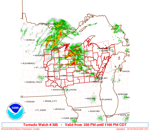
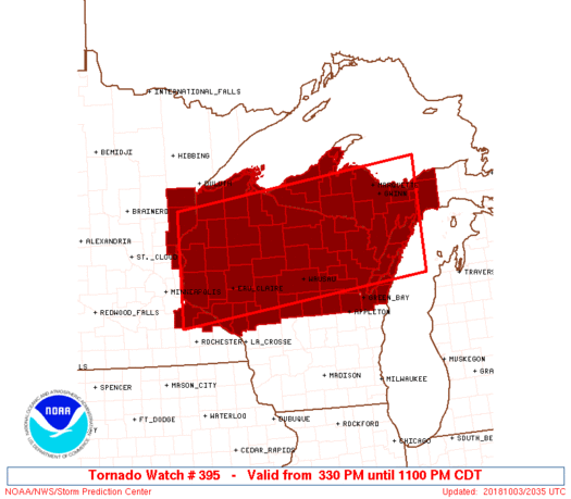
Tornado Watch Number 395
NWS Storm Prediction Center Norman OK
330 PM CDT Wed Oct 3 2018
The NWS Storm Prediction Center has issued a
* Tornado Watch for portions of
Upper Michigan
Eastern Minnesota
Northern and central Wisconsin
Lake Michigan
Lake Superior
* Effective this Wednesday afternoon and evening from 330 PM
until 1100 PM CDT.
* Primary threats include...
A few tornadoes likely with a couple intense tornadoes possible
Scattered damaging winds likely with isolated significant gusts
to 80 mph possible
Scattered large hail and isolated very large hail events to 2
inches in diameter possible
SUMMARY...The air mass will continue to rapidly moisten and
destabilize as a warm front continues to spread northward. This will
allow for storms to continue to intensify. Very strong winds through
a deep-layer will allow for both supercells and bowing segments.
Given the very moist environment and strength of the
deep-layer/low-level winds, a tornado risk exists, a few of which
could be strong/intense. Storms will steadily race
east-northeastward into northeast Wisconsin and the Upper Peninsula
of Michigan this evening.
The tornado watch area is approximately along and 75 statute miles
north and south of a line from 70 miles west northwest of Eau Claire
WI to 35 miles east northeast of Escanaba MI. For a complete
depiction of the watch see the associated watch outline update
(WOUS64 KWNS WOU5).
PRECAUTIONARY/PREPAREDNESS ACTIONS...
REMEMBER...A Tornado Watch means conditions are favorable for
tornadoes and severe thunderstorms in and close to the watch
area. Persons in these areas should be on the lookout for
threatening weather conditions and listen for later statements
and possible warnings.
&&
AVIATION...Tornadoes and a few severe thunderstorms with hail
surface and aloft to 2 inches. Extreme turbulence and surface wind
gusts to 70 knots. A few cumulonimbi with maximum tops to 550. Mean
storm motion vector 24040.
...Guyer

   SEL5

   URGENT - IMMEDIATE BROADCAST REQUESTED
   Tornado Watch Number 395
   NWS Storm Prediction Center Norman OK
   330 PM CDT Wed Oct 3 2018

   The NWS Storm Prediction Center has issued a

   * Tornado Watch for portions of
     Upper Michigan
     Eastern Minnesota
     Northern and central Wisconsin
     Lake Michigan
     Lake Superior

   * Effective this Wednesday afternoon and evening from 330 PM
     until 1100 PM CDT.

   * Primary threats include...
     A few tornadoes likely with a couple intense tornadoes possible
     Scattered damaging winds likely with isolated significant gusts
       to 80 mph possible
     Scattered large hail and isolated very large hail events to 2
       inches in diameter possible

   SUMMARY...The air mass will continue to rapidly moisten and
   destabilize as a warm front continues to spread northward. This will
   allow for storms to continue to intensify. Very strong winds through
   a deep-layer will allow for both supercells and bowing segments.
   Given the very moist environment and strength of the
   deep-layer/low-level winds, a tornado risk exists, a few of which
   could be strong/intense. Storms will steadily race
   east-northeastward into northeast Wisconsin and the Upper Peninsula
   of Michigan this evening.

   The tornado watch area is approximately along and 75 statute miles
   north and south of a line from 70 miles west northwest of Eau Claire
   WI to 35 miles east northeast of Escanaba MI. For a complete
   depiction of the watch see the associated watch outline update
   (WOUS64 KWNS WOU5).

   PRECAUTIONARY/PREPAREDNESS ACTIONS...

   REMEMBER...A Tornado Watch means conditions are favorable for
   tornadoes and severe thunderstorms in and close to the watch
   area. Persons in these areas should be on the lookout for
   threatening weather conditions and listen for later statements
   and possible warnings.

   &&

   AVIATION...Tornadoes and a few severe thunderstorms with hail
   surface and aloft to 2 inches. Extreme turbulence and surface wind
   gusts to 70 knots. A few cumulonimbi with maximum tops to 550. Mean
   storm motion vector 24040.

   ...Guyer
 Note:
The Aviation Watch (SAW) product is an approximation to the watch area.
The actual watch is depicted by the shaded areas.
Note:
The Aviation Watch (SAW) product is an approximation to the watch area.
The actual watch is depicted by the shaded areas.
   SAW5
   WW 395 TORNADO MI MN WI LM LS 032030Z - 040400Z
   AXIS..75 STATUTE MILES NORTH AND SOUTH OF LINE..
   70WNW EAU/EAU CLAIRE WI/ - 35ENE ESC/ESCANABA MI/
   ..AVIATION COORDS.. 65NM N/S /28NE MSP - 48ESE SAW/
   HAIL SURFACE AND ALOFT..2 INCHES. WIND GUSTS..70 KNOTS.
   MAX TOPS TO 550. MEAN STORM MOTION VECTOR 24040.

   LAT...LON 46349280 47008643 44838643 44159280

   THIS IS AN APPROXIMATION TO THE WATCH AREA.  FOR A
   COMPLETE DEPICTION OF THE WATCH SEE WOUS64 KWNS
   FOR WOU5.
Watch 395 Status Report Messages:
STATUS REPORT #4 ON WW 395

VALID 040225Z - 040340Z

SEVERE WEATHER THREAT CONTINUES RIGHT OF A LINE FROM 35 SSE CWA
TO 40 E AUW TO 35 S IMT TO 20 N ESC TO 70 WNW ANJ.

FOR ADDITIONAL INFORMATION SEE MESOSCALE DISCUSSION 1521

..JEWELL..10/04/18

ATTN...WFO...MQT...DLH...MPX...ARX...GRB...

&&

STATUS REPORT FOR WT 395

SEVERE WEATHER THREAT CONTINUES FOR THE FOLLOWING AREAS

MIC041-109-153-040340-

MI
.    MICHIGAN COUNTIES INCLUDED ARE

DELTA		     MENOMINEE		 SCHOOLCRAFT
$$


WIC009-029-061-075-083-087-115-135-040340-

WI
.    WISCONSIN COUNTIES INCLUDED ARE

BROWN		     DOOR		 KEWAUNEE
MARINETTE	     OCONTO		 OUTAGAMIE
SHAWANO 	     WAUPACA
$$


LMZ221-521-522-040340-

CW

.    ADJACENT COASTAL WATERS INCLUDED ARE

GREEN BAY NORTH OF LINE FROM CEDAR RIVER MI TO ROCK ISLAND
PASSAGE

GREEN BAY SOUTH OF LINE FROM  CEDAR RIVER TO ROCK ISLAND PASSAGE
AND NORTH OF A LINE FROM OCONTO WI TO LITTLE STURGEON BAY WI

GREEN BAY SOUTH OF LINE FROM  OCONTO WI TO LITTLE STURGEON BAY WI

$$
THE WATCH STATUS MESSAGE IS FOR GUIDANCE PURPOSES ONLY.  PLEASE
REFER TO WATCH COUNTY NOTIFICATION STATEMENTS FOR OFFICIAL
INFORMATION ON COUNTIES...INDEPENDENT CITIES AND MARINE ZONES
CLEARED FROM SEVERE THUNDERSTORM AND TORNADO WATCHES.
$$

STATUS REPORT #3 ON WW 395

VALID 040130Z - 040240Z

SEVERE WEATHER THREAT CONTINUES RIGHT OF A LINE FROM 25 WNW VOK
TO 25 SW CWA TO 20 N AUW TO 25 NE RHI TO 45 S CMX TO 35 ESE CMX.

..JEWELL..10/04/18

ATTN...WFO...MQT...DLH...MPX...ARX...GRB...

&&

STATUS REPORT FOR WT 395

SEVERE WEATHER THREAT CONTINUES FOR THE FOLLOWING AREAS

MIC003-013-041-043-071-103-109-153-040240-

MI
.    MICHIGAN COUNTIES INCLUDED ARE

ALGER		     BARAGA		 DELTA
DICKINSON	     IRON		 MARQUETTE
MENOMINEE	     SCHOOLCRAFT
$$


WIC009-029-037-041-061-067-073-075-078-083-087-097-115-135-141-
040240-

WI
.    WISCONSIN COUNTIES INCLUDED ARE

BROWN		     DOOR		 FLORENCE
FOREST		     KEWAUNEE		 LANGLADE
MARATHON	     MARINETTE		 MENOMINEE
OCONTO		     OUTAGAMIE		 PORTAGE
SHAWANO 	     WAUPACA		 WOOD
$$


LMZ221-521-522-040240-

CW

.    ADJACENT COASTAL WATERS INCLUDED ARE

GREEN BAY NORTH OF LINE FROM CEDAR RIVER MI TO ROCK ISLAND
PASSAGE

GREEN BAY SOUTH OF LINE FROM  CEDAR RIVER TO ROCK ISLAND PASSAGE
AND NORTH OF A LINE FROM OCONTO WI TO LITTLE STURGEON BAY WI

GREEN BAY SOUTH OF LINE FROM  OCONTO WI TO LITTLE STURGEON BAY WI

$$
THE WATCH STATUS MESSAGE IS FOR GUIDANCE PURPOSES ONLY.  PLEASE
REFER TO WATCH COUNTY NOTIFICATION STATEMENTS FOR OFFICIAL
INFORMATION ON COUNTIES...INDEPENDENT CITIES AND MARINE ZONES
CLEARED FROM SEVERE THUNDERSTORM AND TORNADO WATCHES.
$$

STATUS REPORT #2 ON WW 395

VALID 040025Z - 040140Z

SEVERE WEATHER THREAT CONTINUES RIGHT OF A LINE FROM 35 WNW RST
TO 35 ESE MSP TO 40 NW EAU TO 55 SW ASX TO 20 SSW ASX TO 35 NNW
IWD AND 15 NE RST TO 10 SW EAU TO 40 NNE EAU TO 30 SSW IWD TO 30
NE IWD.

..JEWELL..10/04/18

ATTN...WFO...MQT...DLH...MPX...ARX...GRB...

&&

STATUS REPORT FOR WT 395

SEVERE WEATHER THREAT CONTINUES FOR THE FOLLOWING AREAS

MIC003-013-041-043-053-061-071-103-109-131-153-040140-

MI
.    MICHIGAN COUNTIES INCLUDED ARE

ALGER		     BARAGA		 DELTA
DICKINSON	     GOGEBIC		 HOUGHTON
IRON		     MARQUETTE		 MENOMINEE
ONTONAGON	     SCHOOLCRAFT
$$


WIC009-011-017-019-029-035-037-041-051-053-061-067-069-073-075-
078-083-085-087-097-099-107-115-119-121-125-135-141-040140-

WI
.    WISCONSIN COUNTIES INCLUDED ARE

BROWN		     BUFFALO		 CHIPPEWA
CLARK		     DOOR		 EAU CLAIRE
FLORENCE	     FOREST		 IRON
JACKSON 	     KEWAUNEE		 LANGLADE
LINCOLN 	     MARATHON		 MARINETTE
MENOMINEE	     OCONTO		 ONEIDA
OUTAGAMIE	     PORTAGE		 PRICE
RUSK		     SHAWANO		 TAYLOR
TREMPEALEAU	     VILAS		 WAUPACA
WOOD
$$


LMZ221-521-522-LSZ148-162-040140-

CW

.    ADJACENT COASTAL WATERS INCLUDED ARE

GREEN BAY NORTH OF LINE FROM CEDAR RIVER MI TO ROCK ISLAND
PASSAGE

GREEN BAY SOUTH OF LINE FROM  CEDAR RIVER TO ROCK ISLAND PASSAGE
AND NORTH OF A LINE FROM OCONTO WI TO LITTLE STURGEON BAY WI

GREEN BAY SOUTH OF LINE FROM  OCONTO WI TO LITTLE STURGEON BAY WI

OAK POINT TO SAXON HARBOR WI

LAKE SUPERIOR WEST OF A LINE FROM SAXON HARBOR WI TO GRAND
PORTAGE MN BEYOND 5NM

$$
THE WATCH STATUS MESSAGE IS FOR GUIDANCE PURPOSES ONLY.  PLEASE
REFER TO WATCH COUNTY NOTIFICATION STATEMENTS FOR OFFICIAL
INFORMATION ON COUNTIES...INDEPENDENT CITIES AND MARINE ZONES
CLEARED FROM SEVERE THUNDERSTORM AND TORNADO WATCHES.
$$

STATUS REPORT #1 ON WW 395

VALID 032350Z - 040040Z

SEVERE WEATHER THREAT CONTINUES RIGHT OF A LINE FROM 35 WNW RST
TO 35 ESE MSP TO 40 NW EAU TO 55 SW ASX TO 20 SSW ASX TO 35 NNW
IWD.

..JEWELL..10/03/18

ATTN...WFO...MQT...DLH...MPX...ARX...GRB...

&&

STATUS REPORT FOR WT 395

SEVERE WEATHER THREAT CONTINUES FOR THE FOLLOWING AREAS

MIC003-013-041-043-053-061-071-103-109-131-153-040040-

MI
.    MICHIGAN COUNTIES INCLUDED ARE

ALGER		     BARAGA		 DELTA
DICKINSON	     GOGEBIC		 HOUGHTON
IRON		     MARQUETTE		 MENOMINEE
ONTONAGON	     SCHOOLCRAFT
$$


MNC049-157-040040-

MN
.    MINNESOTA COUNTIES INCLUDED ARE

GOODHUE 	     WABASHA
$$


WIC003-005-009-011-017-019-029-033-035-037-041-051-053-061-067-
069-073-075-078-083-085-087-091-093-097-099-107-113-115-119-121-
125-135-141-040040-

WI
.    WISCONSIN COUNTIES INCLUDED ARE

ASHLAND 	     BARRON		 BROWN
BUFFALO 	     CHIPPEWA		 CLARK
DOOR		     DUNN		 EAU CLAIRE
FLORENCE	     FOREST		 IRON
JACKSON 	     KEWAUNEE		 LANGLADE
LINCOLN 	     MARATHON		 MARINETTE
MENOMINEE	     OCONTO		 ONEIDA
OUTAGAMIE	     PEPIN		 PIERCE
PORTAGE 	     PRICE		 RUSK
SAWYER		     SHAWANO		 TAYLOR
TREMPEALEAU	     VILAS		 WAUPACA
WOOD
$$


LMZ221-521-522-LSZ148-040040-

CW

.    ADJACENT COASTAL WATERS INCLUDED ARE

GREEN BAY NORTH OF LINE FROM CEDAR RIVER MI TO ROCK ISLAND
PASSAGE

GREEN BAY SOUTH OF LINE FROM  CEDAR RIVER TO ROCK ISLAND PASSAGE
AND NORTH OF A LINE FROM OCONTO WI TO LITTLE STURGEON BAY WI

GREEN BAY SOUTH OF LINE FROM  OCONTO WI TO LITTLE STURGEON BAY WI

OAK POINT TO SAXON HARBOR WI

$$
THE WATCH STATUS MESSAGE IS FOR GUIDANCE PURPOSES ONLY.  PLEASE
REFER TO WATCH COUNTY NOTIFICATION STATEMENTS FOR OFFICIAL
INFORMATION ON COUNTIES...INDEPENDENT CITIES AND MARINE ZONES
CLEARED FROM SEVERE THUNDERSTORM AND TORNADO WATCHES.
$$
Note:
Click for Complete Product Text.
Tornadoes
Probability of 2 or more tornadoes
|
High (70%)
|
Probability of 1 or more strong (EF2-EF5) tornadoes
|
Mod (40%)
|
Wind
Probability of 10 or more severe wind events
|
High (70%)
|
Probability of 1 or more wind events > 65 knots
|
Mod (30%)
|
Hail
Probability of 10 or more severe hail events
|
Mod (50%)
|
Probability of 1 or more hailstones > 2 inches
|
Mod (30%)
|
Combined Severe Hail/Wind
Probability of 6 or more combined severe hail/wind events
|
High (>95%)
|
For each watch, probabilities for particular events inside the watch
(listed above in each table) are determined by the issuing forecaster.
The "Low" category contains probability values ranging from less than 2%
to 20% (EF2-EF5 tornadoes), less than 5% to 20% (all other probabilities),
"Moderate" from 30% to 60%, and "High" from 70% to greater than 95%.
High values are bolded and lighter in color to provide awareness of
an increased threat for a particular event.


 @NWSSPC


