 Note:
The expiration time in the watch graphic is amended if the watch is
replaced, cancelled or extended.
Note:
Note:
The expiration time in the watch graphic is amended if the watch is
replaced, cancelled or extended.
Note: Click for
Watch Status Reports.
SEL4
URGENT - IMMEDIATE BROADCAST REQUESTED
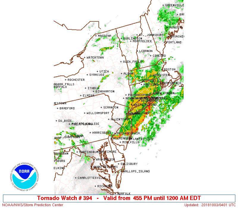
Tornado Watch Number 394
NWS Storm Prediction Center Norman OK
455 PM EDT Tue Oct 2 2018
The NWS Storm Prediction Center has issued a
* Tornado Watch for portions of
Western Connecticut
Northern New Jersey
Southeast New York
* Effective this Tuesday afternoon from 455 PM until Midnight
EDT.
* Primary threats include...
A couple tornadoes possible
Isolated damaging wind gusts to 70 mph possible
Isolated large hail events to 1.5 inches in diameter possible
SUMMARY...Near an effective warm front, at least some supercell
tornado risk will likely persist this evening, and potentially even
somewhat increase as winds just above the surface strengthen across
the region. Aside from a tornado risk, some hail/wind may also
occur.
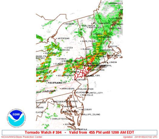
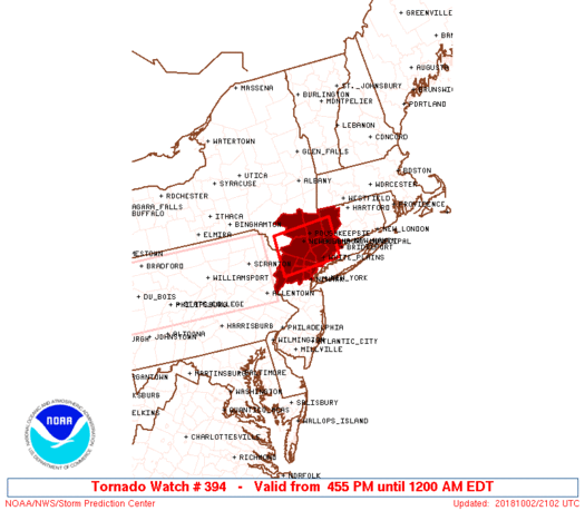
The tornado watch area is approximately along and 30 statute miles
north and south of a line from 55 miles west southwest of
Poughkeepsie NY to 35 miles east southeast of Poughkeepsie NY. For a
complete depiction of the watch see the associated watch outline
update (WOUS64 KWNS WOU4).
PRECAUTIONARY/PREPAREDNESS ACTIONS...
REMEMBER...A Tornado Watch means conditions are favorable for
tornadoes and severe thunderstorms in and close to the watch
area. Persons in these areas should be on the lookout for
threatening weather conditions and listen for later statements
and possible warnings.
&&
OTHER WATCH INFORMATION...CONTINUE...WW 392...WW 393...
AVIATION...Tornadoes and a few severe thunderstorms with hail
surface and aloft to 1.5 inches. Extreme turbulence and surface wind
gusts to 60 knots. A few cumulonimbi with maximum tops to 500. Mean
storm motion vector 27025.
...Guyer

   SEL4

   URGENT - IMMEDIATE BROADCAST REQUESTED
   Tornado Watch Number 394
   NWS Storm Prediction Center Norman OK
   455 PM EDT Tue Oct 2 2018

   The NWS Storm Prediction Center has issued a

   * Tornado Watch for portions of
     Western Connecticut
     Northern New Jersey
     Southeast New York

   * Effective this Tuesday afternoon from 455 PM until Midnight
     EDT.

   * Primary threats include...
     A couple tornadoes possible
     Isolated damaging wind gusts to 70 mph possible
     Isolated large hail events to 1.5 inches in diameter possible

   SUMMARY...Near an effective warm front, at least some supercell
   tornado risk will likely persist this evening, and potentially even
   somewhat increase as winds just above the surface strengthen across
   the region. Aside from a tornado risk, some hail/wind may also
   occur.

   The tornado watch area is approximately along and 30 statute miles
   north and south of a line from 55 miles west southwest of
   Poughkeepsie NY to 35 miles east southeast of Poughkeepsie NY. For a
   complete depiction of the watch see the associated watch outline
   update (WOUS64 KWNS WOU4).

   PRECAUTIONARY/PREPAREDNESS ACTIONS...

   REMEMBER...A Tornado Watch means conditions are favorable for
   tornadoes and severe thunderstorms in and close to the watch
   area. Persons in these areas should be on the lookout for
   threatening weather conditions and listen for later statements
   and possible warnings.

   &&

   OTHER WATCH INFORMATION...CONTINUE...WW 392...WW 393...

   AVIATION...Tornadoes and a few severe thunderstorms with hail
   surface and aloft to 1.5 inches. Extreme turbulence and surface wind
   gusts to 60 knots. A few cumulonimbi with maximum tops to 500. Mean
   storm motion vector 27025.

   ...Guyer
 Note:
The Aviation Watch (SAW) product is an approximation to the watch area.
The actual watch is depicted by the shaded areas.
Note:
The Aviation Watch (SAW) product is an approximation to the watch area.
The actual watch is depicted by the shaded areas.
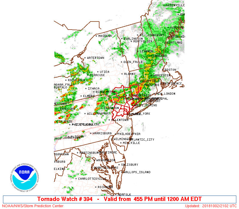
   SAW4
   WW 394 TORNADO CT NJ NY 022055Z - 030400Z
   AXIS..30 STATUTE MILES NORTH AND SOUTH OF LINE..
   55WSW POU/POUGHKEEPSIE NY/ - 35ESE POU/POUGHKEEPSIE NY/
   ..AVIATION COORDS.. 25NM N/S /21NW SAX - 40SW BDL/
   HAIL SURFACE AND ALOFT..1.5 INCHES. WIND GUSTS..60 KNOTS.
   MAX TOPS TO 500. MEAN STORM MOTION VECTOR 27025.

   LAT...LON 41757486 41867326 41007326 40887486

   THIS IS AN APPROXIMATION TO THE WATCH AREA.  FOR A
   COMPLETE DEPICTION OF THE WATCH SEE WOUS64 KWNS
   FOR WOU4.
Watch 394 Status Report Messages:
STATUS REPORT #2 ON WW 394

VALID 030055Z - 030140Z

SEVERE WEATHER THREAT CONTINUES RIGHT OF A LINE FROM 30 S MSV TO
25 WNW ISP.

..SPC..10/03/18

ATTN...WFO...OKX...ALY...PHI...

&&

STATUS REPORT FOR WT 394

SEVERE WEATHER THREAT CONTINUES FOR THE FOLLOWING AREAS

NJC003-013-027-031-037-041-030140-

NJ
.    NEW JERSEY COUNTIES INCLUDED ARE

BERGEN		     ESSEX		 MORRIS
PASSAIC 	     SUSSEX		 WARREN
$$


NYC119-030140-

NY
.    NEW YORK COUNTIES INCLUDED ARE

WESTCHESTER
$$


THE WATCH STATUS MESSAGE IS FOR GUIDANCE PURPOSES ONLY.  PLEASE
REFER TO WATCH COUNTY NOTIFICATION STATEMENTS FOR OFFICIAL
INFORMATION ON COUNTIES...INDEPENDENT CITIES AND MARINE ZONES
CLEARED FROM SEVERE THUNDERSTORM AND TORNADO WATCHES.
$$

STATUS REPORT #1 ON WW 394

VALID 022330Z - 030040Z

SEVERE WEATHER THREAT CONTINUES RIGHT OF A LINE FROM 25 S MSV TO
30 W BDR TO 10 WNW BDR.

..SPC..10/02/18

ATTN...WFO...OKX...ALY...PHI...

&&

STATUS REPORT FOR WT 394

SEVERE WEATHER THREAT CONTINUES FOR THE FOLLOWING AREAS

CTC001-030040-

CT
.    CONNECTICUT COUNTIES INCLUDED ARE

FAIRFIELD
$$


NJC003-013-027-031-037-041-030040-

NJ
.    NEW JERSEY COUNTIES INCLUDED ARE

BERGEN		     ESSEX		 MORRIS
PASSAIC 	     SUSSEX		 WARREN
$$


NYC087-119-030040-

NY
.    NEW YORK COUNTIES INCLUDED ARE

ROCKLAND	     WESTCHESTER
$$


THE WATCH STATUS MESSAGE IS FOR GUIDANCE PURPOSES ONLY.  PLEASE
REFER TO WATCH COUNTY NOTIFICATION STATEMENTS FOR OFFICIAL
INFORMATION ON COUNTIES...INDEPENDENT CITIES AND MARINE ZONES
CLEARED FROM SEVERE THUNDERSTORM AND TORNADO WATCHES.
$$
Note:
Click for Complete Product Text.
Tornadoes
Probability of 2 or more tornadoes
|
Mod (40%)
|
Probability of 1 or more strong (EF2-EF5) tornadoes
|
Low (20%)
|
Wind
Probability of 10 or more severe wind events
|
Mod (30%)
|
Probability of 1 or more wind events > 65 knots
|
Low (20%)
|
Hail
Probability of 10 or more severe hail events
|
Low (20%)
|
Probability of 1 or more hailstones > 2 inches
|
Low (<5%)
|
Combined Severe Hail/Wind
Probability of 6 or more combined severe hail/wind events
|
Mod (50%)
|
For each watch, probabilities for particular events inside the watch
(listed above in each table) are determined by the issuing forecaster.
The "Low" category contains probability values ranging from less than 2%
to 20% (EF2-EF5 tornadoes), less than 5% to 20% (all other probabilities),
"Moderate" from 30% to 60%, and "High" from 70% to greater than 95%.
High values are bolded and lighter in color to provide awareness of
an increased threat for a particular event.


 @NWSSPC