 Note:
The expiration time in the watch graphic is amended if the watch is
replaced, cancelled or extended.
Note:
Note:
The expiration time in the watch graphic is amended if the watch is
replaced, cancelled or extended.
Note: Click for
Watch Status Reports.
SEL1
URGENT - IMMEDIATE BROADCAST REQUESTED
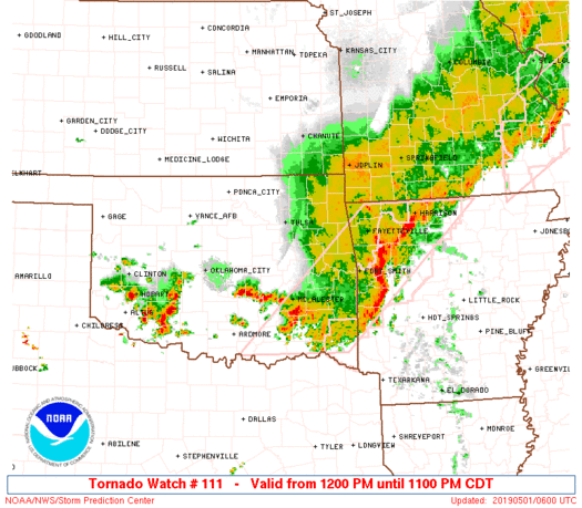
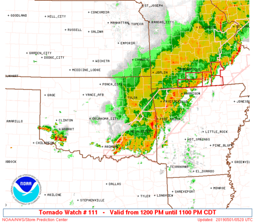
Tornado Watch Number 111
NWS Storm Prediction Center Norman OK
1200 PM CDT Tue Apr 30 2019
The NWS Storm Prediction Center has issued a
* Tornado Watch for portions of
Northwest Arkansas
Southeast Kansas
Southwest Missouri
Central and Eastern Oklahoma
* Effective this Tuesday afternoon and evening from NOON until
1100 PM CDT.
* Primary threats include...
A few tornadoes likely with a couple intense tornadoes possible
Widespread large hail and isolated very large hail events to 3
inches in diameter likely
Widespread damaging wind gusts to 70 mph likely
SUMMARY...Numerous rounds of thunderstorms will affect the watch
area this afternoon and evening, with parameters favorable for a
risk of large hail, damaging winds, and a few tornadoes. A strong
tornado or two is possible by late afternoon and early evening.
The tornado watch area is approximately along and 85 statute miles
east and west of a line from 45 miles northeast of Joplin MO to 30
miles south of Ardmore OK. For a complete depiction of the watch see
the associated watch outline update (WOUS64 KWNS WOU1).
PRECAUTIONARY/PREPAREDNESS ACTIONS...
REMEMBER...A Tornado Watch means conditions are favorable for
tornadoes and severe thunderstorms in and close to the watch
area. Persons in these areas should be on the lookout for
threatening weather conditions and listen for later statements
and possible warnings.
&&
AVIATION...Tornadoes and a few severe thunderstorms with hail
surface and aloft to 3 inches. Extreme turbulence and surface wind
gusts to 60 knots. A few cumulonimbi with maximum tops to 500. Mean
storm motion vector 24035.
...Hart
   SEL1

   URGENT - IMMEDIATE BROADCAST REQUESTED
   Tornado Watch Number 111
   NWS Storm Prediction Center Norman OK
   1200 PM CDT Tue Apr 30 2019

   The NWS Storm Prediction Center has issued a

   * Tornado Watch for portions of
     Northwest Arkansas
     Southeast Kansas
     Southwest Missouri
     Central and Eastern Oklahoma

   * Effective this Tuesday afternoon and evening from NOON until
     1100 PM CDT.

   * Primary threats include...
     A few tornadoes likely with a couple intense tornadoes possible
     Widespread large hail and isolated very large hail events to 3
       inches in diameter likely
     Widespread damaging wind gusts to 70 mph likely

   SUMMARY...Numerous rounds of thunderstorms will affect the watch
   area this afternoon and evening, with parameters favorable for a
   risk of large hail, damaging winds, and a few tornadoes.  A strong
   tornado or two is possible by late afternoon and early evening.

   The tornado watch area is approximately along and 85 statute miles
   east and west of a line from 45 miles northeast of Joplin MO to 30
   miles south of Ardmore OK. For a complete depiction of the watch see
   the associated watch outline update (WOUS64 KWNS WOU1).

   PRECAUTIONARY/PREPAREDNESS ACTIONS...

   REMEMBER...A Tornado Watch means conditions are favorable for
   tornadoes and severe thunderstorms in and close to the watch
   area. Persons in these areas should be on the lookout for
   threatening weather conditions and listen for later statements
   and possible warnings.

   &&

   AVIATION...Tornadoes and a few severe thunderstorms with hail
   surface and aloft to 3 inches. Extreme turbulence and surface wind
   gusts to 60 knots. A few cumulonimbi with maximum tops to 500. Mean
   storm motion vector 24035.

   ...Hart
 Note:
The Aviation Watch (SAW) product is an approximation to the watch area.
The actual watch is depicted by the shaded areas.
Note:
The Aviation Watch (SAW) product is an approximation to the watch area.
The actual watch is depicted by the shaded areas.
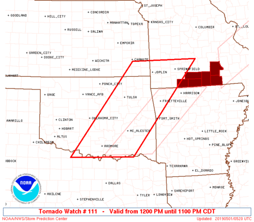
   SAW1
   WW 111 TORNADO AR KS MO OK 301700Z - 010400Z
   AXIS..85 STATUTE MILES EAST AND WEST OF LINE..
   45NE JLN/JOPLIN MO/ - 30S ADM/ARDMORE OK/
   ..AVIATION COORDS.. 75NM E/W /32WNW SGF - 23SSE ADM/
   HAIL SURFACE AND ALOFT..3 INCHES. WIND GUSTS..60 KNOTS.
   MAX TOPS TO 500. MEAN STORM MOTION VECTOR 24035.

   LAT...LON 37599237 33849554 33849850 37599547

   THIS IS AN APPROXIMATION TO THE WATCH AREA.  FOR A
   COMPLETE DEPICTION OF THE WATCH SEE WOUS64 KWNS
   FOR WOU1.
Watch 111 Status Report Messages:
STATUS REPORT #10 ON WW 111
VALID 010250Z - 010340Z
SEVERE WEATHER THREAT CONTINUES RIGHT OF A LINE FROM 15 SSW SPS
TO 35 NNE ADM TO 25 WNW MKO TO 5 E GMJ TO 35 ESE SGF TO 20 WNW
TBN TO 35 WSW JEF.
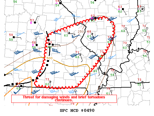
FOR ADDITIONAL INFORMATION SEE MESOSCALE DISCUSSION 489
..DEAN..05/01/19
ATTN...WFO...TSA...SGF...ICT...OUN...
&&
STATUS REPORT FOR WT 111
SEVERE WEATHER THREAT CONTINUES FOR THE FOLLOWING AREAS
ARC007-015-033-047-087-131-143-010340-
AR
. ARKANSAS COUNTIES INCLUDED ARE
BENTON CARROLL CRAWFORD
FRANKLIN MADISON SEBASTIAN
WASHINGTON
$$
MOC009-043-065-067-091-105-119-149-153-161-169-203-209-213-215-
229-010340-
MO
. MISSOURI COUNTIES INCLUDED ARE
BARRY CHRISTIAN DENT
DOUGLAS HOWELL LACLEDE
MCDONALD OREGON OZARK
PHELPS PULASKI SHANNON
STONE TANEY TEXAS
WRIGHT
$$
OKC001-005-013-019-021-023-029-041-061-063-067-069-077-079-085-
091-095-097-099-101-107-111-121-123-127-135-145-010340-
OK
. OKLAHOMA COUNTIES INCLUDED ARE
ADAIR ATOKA BRYAN
CARTER CHEROKEE CHOCTAW
COAL DELAWARE HASKELL
HUGHES JEFFERSON JOHNSTON
LATIMER LE FLORE LOVE
MCINTOSH MARSHALL MAYES
MURRAY MUSKOGEE OKFUSKEE
OKMULGEE PITTSBURG PONTOTOC
PUSHMATAHA SEQUOYAH WAGONER
$$
THE WATCH STATUS MESSAGE IS FOR GUIDANCE PURPOSES ONLY. PLEASE
REFER TO WATCH COUNTY NOTIFICATION STATEMENTS FOR OFFICIAL
INFORMATION ON COUNTIES...INDEPENDENT CITIES AND MARINE ZONES
CLEARED FROM SEVERE THUNDERSTORM AND TORNADO WATCHES.
$$
STATUS REPORT #9 ON WW 111
VALID 010140Z - 010240Z
SEVERE WEATHER THREAT CONTINUES RIGHT OF A LINE FROM 10 N SPS TO
35 NW ADM TO 25 SE CQB TO 5 S TUL TO 5 W UMN TO 40 N SGF.
..DEAN..05/01/19
ATTN...WFO...TSA...SGF...ICT...OUN...
&&
STATUS REPORT FOR WT 111
SEVERE WEATHER THREAT CONTINUES FOR THE FOLLOWING AREAS
ARC007-015-033-047-087-131-143-010240-
AR
. ARKANSAS COUNTIES INCLUDED ARE
BENTON CARROLL CRAWFORD
FRANKLIN MADISON SEBASTIAN
WASHINGTON
$$
MOC009-029-043-059-065-067-077-091-105-109-119-149-153-161-167-
169-203-209-213-215-225-229-010240-
MO
. MISSOURI COUNTIES INCLUDED ARE
BARRY CAMDEN CHRISTIAN
DALLAS DENT DOUGLAS
GREENE HOWELL LACLEDE
LAWRENCE MCDONALD OREGON
OZARK PHELPS POLK
PULASKI SHANNON STONE
TANEY TEXAS WEBSTER
WRIGHT
$$
OKC001-005-013-019-021-023-029-033-041-049-061-063-067-069-077-
079-085-091-095-097-099-101-107-111-121-123-125-127-133-135-137-
145-010240-
OK
. OKLAHOMA COUNTIES INCLUDED ARE
ADAIR ATOKA BRYAN
CARTER CHEROKEE CHOCTAW
COAL COTTON DELAWARE
GARVIN HASKELL HUGHES
JEFFERSON JOHNSTON LATIMER
LE FLORE LOVE MCINTOSH
MARSHALL MAYES MURRAY
MUSKOGEE OKFUSKEE OKMULGEE
PITTSBURG PONTOTOC POTTAWATOMIE
PUSHMATAHA SEMINOLE SEQUOYAH
STEPHENS WAGONER
$$
THE WATCH STATUS MESSAGE IS FOR GUIDANCE PURPOSES ONLY. PLEASE
REFER TO WATCH COUNTY NOTIFICATION STATEMENTS FOR OFFICIAL
INFORMATION ON COUNTIES...INDEPENDENT CITIES AND MARINE ZONES
CLEARED FROM SEVERE THUNDERSTORM AND TORNADO WATCHES.
$$
STATUS REPORT #8 ON WW 111
VALID 010045Z - 010140Z
SEVERE WEATHER THREAT CONTINUES RIGHT OF A LINE FROM 25 NNW SPS
TO 30 ESE CHK TO 20 SSE CQB TO 25 WSW TUL TO 15 WNW GMJ TO 10 ESE
JLN TO 30 S SZL.
..DEAN..05/01/19
ATTN...WFO...TSA...SGF...ICT...OUN...
&&
STATUS REPORT FOR WT 111
SEVERE WEATHER THREAT CONTINUES FOR THE FOLLOWING AREAS
ARC007-015-033-047-087-131-143-010140-
AR
. ARKANSAS COUNTIES INCLUDED ARE
BENTON CARROLL CRAWFORD
FRANKLIN MADISON SEBASTIAN
WASHINGTON
$$
MOC009-039-043-057-059-065-067-077-091-097-105-109-119-145-149-
153-167-203-209-213-215-225-229-010140-
MO
. MISSOURI COUNTIES INCLUDED ARE
BARRY CEDAR CHRISTIAN
DADE DALLAS DENT
DOUGLAS GREENE HOWELL
JASPER LACLEDE LAWRENCE
MCDONALD NEWTON OREGON
OZARK POLK SHANNON
STONE TANEY TEXAS
WEBSTER WRIGHT
$$
OKC001-005-013-019-021-023-027-029-033-035-037-041-049-061-063-
067-069-077-079-085-087-091-095-097-099-101-107-111-115-121-123-
125-127-131-133-135-137-143-145-010140-
OK
. OKLAHOMA COUNTIES INCLUDED ARE
ADAIR ATOKA BRYAN
CARTER CHEROKEE CHOCTAW
CLEVELAND COAL COTTON
CRAIG CREEK DELAWARE
GARVIN HASKELL HUGHES
JEFFERSON JOHNSTON LATIMER
LE FLORE LOVE MCCLAIN
MCINTOSH MARSHALL MAYES
MURRAY MUSKOGEE OKFUSKEE
OKMULGEE OTTAWA PITTSBURG
PONTOTOC POTTAWATOMIE PUSHMATAHA
ROGERS SEMINOLE SEQUOYAH
STEPHENS TULSA WAGONER
$$
THE WATCH STATUS MESSAGE IS FOR GUIDANCE PURPOSES ONLY. PLEASE
REFER TO WATCH COUNTY NOTIFICATION STATEMENTS FOR OFFICIAL
INFORMATION ON COUNTIES...INDEPENDENT CITIES AND MARINE ZONES
CLEARED FROM SEVERE THUNDERSTORM AND TORNADO WATCHES.
$$
STATUS REPORT #7 ON WW 111
VALID 302350Z - 010040Z
SEVERE WEATHER THREAT CONTINUES RIGHT OF A LINE FROM 25 SW FSI TO
15 SSE CHK TO 5 NE CQB TO 10 E BVO TO 25 W JLN TO 30 NNW JLN TO
50 SSE OJC.
FOR ADDITIONAL INFORMATION SEE MESOSCALE DISCUSSION 486
..DEAN..04/30/19
ATTN...WFO...TSA...SGF...ICT...OUN...
&&
STATUS REPORT FOR WT 111
SEVERE WEATHER THREAT CONTINUES FOR THE FOLLOWING AREAS
ARC007-015-033-047-087-131-143-010040-
AR
. ARKANSAS COUNTIES INCLUDED ARE
BENTON CARROLL CRAWFORD
FRANKLIN MADISON SEBASTIAN
WASHINGTON
$$
KSC021-037-010040-
KS
. KANSAS COUNTIES INCLUDED ARE
CHEROKEE CRAWFORD
$$
MOC009-011-039-043-057-059-065-067-077-091-097-105-109-119-145-
149-153-167-203-209-213-215-217-225-229-010040-
MO
. MISSOURI COUNTIES INCLUDED ARE
BARRY BARTON CEDAR
CHRISTIAN DADE DALLAS
DENT DOUGLAS GREENE
HOWELL JASPER LACLEDE
LAWRENCE MCDONALD NEWTON
OREGON OZARK POLK
SHANNON STONE TANEY
TEXAS VERNON WEBSTER
WRIGHT
$$
OKC001-005-013-019-021-023-027-029-031-033-035-037-041-049-051-
061-063-067-069-077-079-081-085-087-091-095-097-099-101-105-107-
111-113-115-121-123-125-127-131-133-135-137-141-143-145-147-
010040-
OK
. OKLAHOMA COUNTIES INCLUDED ARE
ADAIR ATOKA BRYAN
CARTER CHEROKEE CHOCTAW
CLEVELAND COAL COMANCHE
COTTON CRAIG CREEK
DELAWARE GARVIN GRADY
HASKELL HUGHES JEFFERSON
JOHNSTON LATIMER LE FLORE
LINCOLN LOVE MCCLAIN
MCINTOSH MARSHALL MAYES
MURRAY MUSKOGEE NOWATA
OKFUSKEE OKMULGEE OSAGE
OTTAWA PITTSBURG PONTOTOC
POTTAWATOMIE PUSHMATAHA ROGERS
SEMINOLE SEQUOYAH STEPHENS
TILLMAN TULSA WAGONER
WASHINGTON
$$
THE WATCH STATUS MESSAGE IS FOR GUIDANCE PURPOSES ONLY. PLEASE
REFER TO WATCH COUNTY NOTIFICATION STATEMENTS FOR OFFICIAL
INFORMATION ON COUNTIES...INDEPENDENT CITIES AND MARINE ZONES
CLEARED FROM SEVERE THUNDERSTORM AND TORNADO WATCHES.
$$
STATUS REPORT #6 ON WW 111
VALID 302230Z - 302340Z
THE SEVERE WEATHER THREAT CONTINUES ACROSS THE ENTIRE WATCH AREA.
FOR ADDITIONAL INFORMATION SEE MESOSCALE DISCUSSION 485
..DEAN..04/30/19
ATTN...WFO...TSA...SGF...ICT...OUN...
&&
STATUS REPORT FOR WT 111
SEVERE WEATHER THREAT CONTINUES FOR THE FOLLOWING AREAS
ARC007-015-033-047-087-131-143-302340-
AR
. ARKANSAS COUNTIES INCLUDED ARE
BENTON CARROLL CRAWFORD
FRANKLIN MADISON SEBASTIAN
WASHINGTON
$$
KSC011-021-037-099-125-133-302340-
KS
. KANSAS COUNTIES INCLUDED ARE
BOURBON CHEROKEE CRAWFORD
LABETTE MONTGOMERY NEOSHO
$$
MOC009-011-039-043-057-059-065-067-077-091-097-105-109-119-145-
149-153-167-203-209-213-215-217-225-229-302340-
MO
. MISSOURI COUNTIES INCLUDED ARE
BARRY BARTON CEDAR
CHRISTIAN DADE DALLAS
DENT DOUGLAS GREENE
HOWELL JASPER LACLEDE
LAWRENCE MCDONALD NEWTON
OREGON OZARK POLK
SHANNON STONE TANEY
TEXAS VERNON WEBSTER
WRIGHT
$$
OKC001-005-013-015-019-021-023-027-029-031-033-035-037-041-049-
051-061-063-067-069-077-079-081-083-085-087-091-095-097-099-101-
105-107-109-111-113-115-117-119-121-123-125-127-131-133-135-137-
141-143-145-147-302340-
OK
. OKLAHOMA COUNTIES INCLUDED ARE
ADAIR ATOKA BRYAN
CADDO CARTER CHEROKEE
CHOCTAW CLEVELAND COAL
COMANCHE COTTON CRAIG
CREEK DELAWARE GARVIN
GRADY HASKELL HUGHES
JEFFERSON JOHNSTON LATIMER
LE FLORE LINCOLN LOGAN
LOVE MCCLAIN MCINTOSH
MARSHALL MAYES MURRAY
MUSKOGEE NOWATA OKFUSKEE
OKLAHOMA OKMULGEE OSAGE
OTTAWA PAWNEE PAYNE
PITTSBURG PONTOTOC POTTAWATOMIE
PUSHMATAHA ROGERS SEMINOLE
SEQUOYAH STEPHENS TILLMAN
TULSA WAGONER WASHINGTON
$$
THE WATCH STATUS MESSAGE IS FOR GUIDANCE PURPOSES ONLY. PLEASE
REFER TO WATCH COUNTY NOTIFICATION STATEMENTS FOR OFFICIAL
INFORMATION ON COUNTIES...INDEPENDENT CITIES AND MARINE ZONES
CLEARED FROM SEVERE THUNDERSTORM AND TORNADO WATCHES.
$$
STATUS REPORT #5 ON WW 111
VALID 302135Z - 302240Z
THE SEVERE WEATHER THREAT CONTINUES ACROSS THE ENTIRE WATCH AREA.
FOR ADDITIONAL INFORMATION SEE MESOSCALE DISCUSSION 483
..DEAN..04/30/19
ATTN...WFO...TSA...SGF...ICT...OUN...
&&
STATUS REPORT FOR WT 111
SEVERE WEATHER THREAT CONTINUES FOR THE FOLLOWING AREAS
ARC007-015-033-047-087-131-143-302240-
AR
. ARKANSAS COUNTIES INCLUDED ARE
BENTON CARROLL CRAWFORD
FRANKLIN MADISON SEBASTIAN
WASHINGTON
$$
KSC011-021-037-099-125-133-302240-
KS
. KANSAS COUNTIES INCLUDED ARE
BOURBON CHEROKEE CRAWFORD
LABETTE MONTGOMERY NEOSHO
$$
MOC009-011-039-043-057-059-065-067-077-091-097-105-109-119-145-
149-153-167-203-209-213-215-217-225-229-302240-
MO
. MISSOURI COUNTIES INCLUDED ARE
BARRY BARTON CEDAR
CHRISTIAN DADE DALLAS
DENT DOUGLAS GREENE
HOWELL JASPER LACLEDE
LAWRENCE MCDONALD NEWTON
OREGON OZARK POLK
SHANNON STONE TANEY
TEXAS VERNON WEBSTER
WRIGHT
$$
OKC001-005-013-015-019-021-023-027-029-031-033-035-037-041-049-
051-061-063-067-069-077-079-081-083-085-087-091-095-097-099-101-
105-107-109-111-113-115-117-119-121-123-125-127-131-133-135-137-
141-143-145-147-302240-
OK
. OKLAHOMA COUNTIES INCLUDED ARE
ADAIR ATOKA BRYAN
CADDO CARTER CHEROKEE
CHOCTAW CLEVELAND COAL
COMANCHE COTTON CRAIG
CREEK DELAWARE GARVIN
GRADY HASKELL HUGHES
JEFFERSON JOHNSTON LATIMER
LE FLORE LINCOLN LOGAN
LOVE MCCLAIN MCINTOSH
MARSHALL MAYES MURRAY
MUSKOGEE NOWATA OKFUSKEE
OKLAHOMA OKMULGEE OSAGE
OTTAWA PAWNEE PAYNE
PITTSBURG PONTOTOC POTTAWATOMIE
PUSHMATAHA ROGERS SEMINOLE
SEQUOYAH STEPHENS TILLMAN
TULSA WAGONER WASHINGTON
$$
THE WATCH STATUS MESSAGE IS FOR GUIDANCE PURPOSES ONLY. PLEASE
REFER TO WATCH COUNTY NOTIFICATION STATEMENTS FOR OFFICIAL
INFORMATION ON COUNTIES...INDEPENDENT CITIES AND MARINE ZONES
CLEARED FROM SEVERE THUNDERSTORM AND TORNADO WATCHES.
$$
STATUS REPORT #4 ON WW 111
VALID 302040Z - 302140Z
THE SEVERE WEATHER THREAT CONTINUES ACROSS THE ENTIRE WATCH AREA.
..BROYLES..04/30/19
ATTN...WFO...TSA...SGF...ICT...OUN...
&&
STATUS REPORT FOR WT 111
SEVERE WEATHER THREAT CONTINUES FOR THE FOLLOWING AREAS
ARC007-015-033-047-087-131-143-302140-
AR
. ARKANSAS COUNTIES INCLUDED ARE
BENTON CARROLL CRAWFORD
FRANKLIN MADISON SEBASTIAN
WASHINGTON
$$
KSC011-021-037-099-125-133-302140-
KS
. KANSAS COUNTIES INCLUDED ARE
BOURBON CHEROKEE CRAWFORD
LABETTE MONTGOMERY NEOSHO
$$
MOC009-011-039-043-057-059-077-097-109-119-145-167-209-213-217-
225-302140-
MO
. MISSOURI COUNTIES INCLUDED ARE
BARRY BARTON CEDAR
CHRISTIAN DADE DALLAS
GREENE JASPER LAWRENCE
MCDONALD NEWTON POLK
STONE TANEY VERNON
WEBSTER
$$
OKC001-005-013-019-021-023-027-029-031-033-035-037-041-049-051-
061-063-067-069-077-079-081-083-085-087-091-095-097-099-101-105-
107-109-111-113-115-117-119-121-123-125-127-131-133-135-137-143-
145-147-302140-
OK
. OKLAHOMA COUNTIES INCLUDED ARE
ADAIR ATOKA BRYAN
CARTER CHEROKEE CHOCTAW
CLEVELAND COAL COMANCHE
COTTON CRAIG CREEK
DELAWARE GARVIN GRADY
HASKELL HUGHES JEFFERSON
JOHNSTON LATIMER LE FLORE
LINCOLN LOGAN LOVE
MCCLAIN MCINTOSH MARSHALL
MAYES MURRAY MUSKOGEE
NOWATA OKFUSKEE OKLAHOMA
OKMULGEE OSAGE OTTAWA
PAWNEE PAYNE PITTSBURG
PONTOTOC POTTAWATOMIE PUSHMATAHA
ROGERS SEMINOLE SEQUOYAH
STEPHENS TULSA WAGONER
WASHINGTON
$$
THE WATCH STATUS MESSAGE IS FOR GUIDANCE PURPOSES ONLY. PLEASE
REFER TO WATCH COUNTY NOTIFICATION STATEMENTS FOR OFFICIAL
INFORMATION ON COUNTIES...INDEPENDENT CITIES AND MARINE ZONES
CLEARED FROM SEVERE THUNDERSTORM AND TORNADO WATCHES.
$$
STATUS REPORT #3 ON WW 111
VALID 301945Z - 302040Z
THE SEVERE WEATHER THREAT CONTINUES ACROSS THE ENTIRE WATCH AREA.
..BROYLES..04/30/19
ATTN...WFO...TSA...SGF...ICT...OUN...
&&
STATUS REPORT FOR WT 111
SEVERE WEATHER THREAT CONTINUES FOR THE FOLLOWING AREAS
ARC007-015-033-047-087-131-143-302040-
AR
. ARKANSAS COUNTIES INCLUDED ARE
BENTON CARROLL CRAWFORD
FRANKLIN MADISON SEBASTIAN
WASHINGTON
$$
KSC011-021-037-099-125-133-302040-
KS
. KANSAS COUNTIES INCLUDED ARE
BOURBON CHEROKEE CRAWFORD
LABETTE MONTGOMERY NEOSHO
$$
MOC009-011-039-043-057-059-077-097-109-119-145-167-209-213-217-
225-302040-
MO
. MISSOURI COUNTIES INCLUDED ARE
BARRY BARTON CEDAR
CHRISTIAN DADE DALLAS
GREENE JASPER LAWRENCE
MCDONALD NEWTON POLK
STONE TANEY VERNON
WEBSTER
$$
OKC001-005-013-019-021-023-027-029-031-033-035-037-041-049-051-
061-063-067-069-077-079-081-083-085-087-091-095-097-099-101-105-
107-109-111-113-115-117-119-121-123-125-127-131-133-135-137-143-
145-147-302040-
OK
. OKLAHOMA COUNTIES INCLUDED ARE
ADAIR ATOKA BRYAN
CARTER CHEROKEE CHOCTAW
CLEVELAND COAL COMANCHE
COTTON CRAIG CREEK
DELAWARE GARVIN GRADY
HASKELL HUGHES JEFFERSON
JOHNSTON LATIMER LE FLORE
LINCOLN LOGAN LOVE
MCCLAIN MCINTOSH MARSHALL
MAYES MURRAY MUSKOGEE
NOWATA OKFUSKEE OKLAHOMA
OKMULGEE OSAGE OTTAWA
PAWNEE PAYNE PITTSBURG
PONTOTOC POTTAWATOMIE PUSHMATAHA
ROGERS SEMINOLE SEQUOYAH
STEPHENS TULSA WAGONER
WASHINGTON
$$
THE WATCH STATUS MESSAGE IS FOR GUIDANCE PURPOSES ONLY. PLEASE
REFER TO WATCH COUNTY NOTIFICATION STATEMENTS FOR OFFICIAL
INFORMATION ON COUNTIES...INDEPENDENT CITIES AND MARINE ZONES
CLEARED FROM SEVERE THUNDERSTORM AND TORNADO WATCHES.
$$
STATUS REPORT #2 ON WW 111
VALID 301825Z - 301940Z
THE SEVERE WEATHER THREAT CONTINUES ACROSS THE ENTIRE WATCH AREA.
..BROYLES..04/30/19
ATTN...WFO...TSA...SGF...ICT...OUN...
&&
STATUS REPORT FOR WT 111
SEVERE WEATHER THREAT CONTINUES FOR THE FOLLOWING AREAS
ARC007-015-033-047-087-131-143-301940-
AR
. ARKANSAS COUNTIES INCLUDED ARE
BENTON CARROLL CRAWFORD
FRANKLIN MADISON SEBASTIAN
WASHINGTON
$$
KSC011-021-037-099-125-133-301940-
KS
. KANSAS COUNTIES INCLUDED ARE
BOURBON CHEROKEE CRAWFORD
LABETTE MONTGOMERY NEOSHO
$$
MOC009-011-039-043-057-059-077-097-109-119-145-167-209-213-217-
225-301940-
MO
. MISSOURI COUNTIES INCLUDED ARE
BARRY BARTON CEDAR
CHRISTIAN DADE DALLAS
GREENE JASPER LAWRENCE
MCDONALD NEWTON POLK
STONE TANEY VERNON
WEBSTER
$$
OKC001-005-013-019-021-023-027-029-031-033-035-037-041-049-051-
061-063-067-069-077-079-081-083-085-087-091-095-097-099-101-105-
107-109-111-113-115-117-119-121-123-125-127-131-133-135-137-143-
145-147-301940-
OK
. OKLAHOMA COUNTIES INCLUDED ARE
ADAIR ATOKA BRYAN
CARTER CHEROKEE CHOCTAW
CLEVELAND COAL COMANCHE
COTTON CRAIG CREEK
DELAWARE GARVIN GRADY
HASKELL HUGHES JEFFERSON
JOHNSTON LATIMER LE FLORE
LINCOLN LOGAN LOVE
MCCLAIN MCINTOSH MARSHALL
MAYES MURRAY MUSKOGEE
NOWATA OKFUSKEE OKLAHOMA
OKMULGEE OSAGE OTTAWA
PAWNEE PAYNE PITTSBURG
PONTOTOC POTTAWATOMIE PUSHMATAHA
ROGERS SEMINOLE SEQUOYAH
STEPHENS TULSA WAGONER
WASHINGTON
$$
THE WATCH STATUS MESSAGE IS FOR GUIDANCE PURPOSES ONLY. PLEASE
REFER TO WATCH COUNTY NOTIFICATION STATEMENTS FOR OFFICIAL
INFORMATION ON COUNTIES...INDEPENDENT CITIES AND MARINE ZONES
CLEARED FROM SEVERE THUNDERSTORM AND TORNADO WATCHES.
$$
STATUS REPORT #1 ON WW 111
VALID 301740Z - 301840Z
THE SEVERE WEATHER THREAT CONTINUES ACROSS THE ENTIRE WATCH AREA.
..BROYLES..04/30/19
ATTN...WFO...TSA...SGF...ICT...OUN...
&&
STATUS REPORT FOR WT 111
SEVERE WEATHER THREAT CONTINUES FOR THE FOLLOWING AREAS
ARC007-015-033-047-087-131-143-301840-
AR
. ARKANSAS COUNTIES INCLUDED ARE
BENTON CARROLL CRAWFORD
FRANKLIN MADISON SEBASTIAN
WASHINGTON
$$
KSC011-021-037-099-125-133-301840-
KS
. KANSAS COUNTIES INCLUDED ARE
BOURBON CHEROKEE CRAWFORD
LABETTE MONTGOMERY NEOSHO
$$
MOC009-011-039-043-057-059-077-097-109-119-145-167-209-213-217-
225-301840-
MO
. MISSOURI COUNTIES INCLUDED ARE
BARRY BARTON CEDAR
CHRISTIAN DADE DALLAS
GREENE JASPER LAWRENCE
MCDONALD NEWTON POLK
STONE TANEY VERNON
WEBSTER
$$
OKC001-005-013-019-021-023-027-029-031-033-035-037-041-049-051-
061-063-067-069-077-079-081-083-085-087-091-095-097-099-101-105-
107-109-111-113-115-117-119-121-123-125-127-131-133-135-137-143-
145-147-301840-
OK
. OKLAHOMA COUNTIES INCLUDED ARE
ADAIR ATOKA BRYAN
CARTER CHEROKEE CHOCTAW
CLEVELAND COAL COMANCHE
COTTON CRAIG CREEK
DELAWARE GARVIN GRADY
HASKELL HUGHES JEFFERSON
JOHNSTON LATIMER LE FLORE
LINCOLN LOGAN LOVE
MCCLAIN MCINTOSH MARSHALL
MAYES MURRAY MUSKOGEE
NOWATA OKFUSKEE OKLAHOMA
OKMULGEE OSAGE OTTAWA
PAWNEE PAYNE PITTSBURG
PONTOTOC POTTAWATOMIE PUSHMATAHA
ROGERS SEMINOLE SEQUOYAH
STEPHENS TULSA WAGONER
WASHINGTON
$$
THE WATCH STATUS MESSAGE IS FOR GUIDANCE PURPOSES ONLY. PLEASE
REFER TO WATCH COUNTY NOTIFICATION STATEMENTS FOR OFFICIAL
INFORMATION ON COUNTIES...INDEPENDENT CITIES AND MARINE ZONES
CLEARED FROM SEVERE THUNDERSTORM AND TORNADO WATCHES.
$$
Note:
Click for Complete Product Text.
Tornadoes
Probability of 2 or more tornadoes
|
High (70%)
|
Probability of 1 or more strong (EF2-EF5) tornadoes
|
Mod (50%)
|
Wind
Probability of 10 or more severe wind events
|
High (80%)
|
Probability of 1 or more wind events > 65 knots
|
Low (20%)
|
Hail
Probability of 10 or more severe hail events
|
High (90%)
|
Probability of 1 or more hailstones > 2 inches
|
Mod (60%)
|
Combined Severe Hail/Wind
Probability of 6 or more combined severe hail/wind events
|
High (>95%)
|
For each watch, probabilities for particular events inside the watch
(listed above in each table) are determined by the issuing forecaster.
The "Low" category contains probability values ranging from less than 2%
to 20% (EF2-EF5 tornadoes), less than 5% to 20% (all other probabilities),
"Moderate" from 30% to 60%, and "High" from 70% to greater than 95%.
High values are bolded and lighter in color to provide awareness of
an increased threat for a particular event.


 @NWSSPC