 Note:
The expiration time in the watch graphic is amended if the watch is
replaced, cancelled or extended.
Note:
Note:
The expiration time in the watch graphic is amended if the watch is
replaced, cancelled or extended.
Note: Click for
Watch Status Reports.
SEL6
URGENT - IMMEDIATE BROADCAST REQUESTED
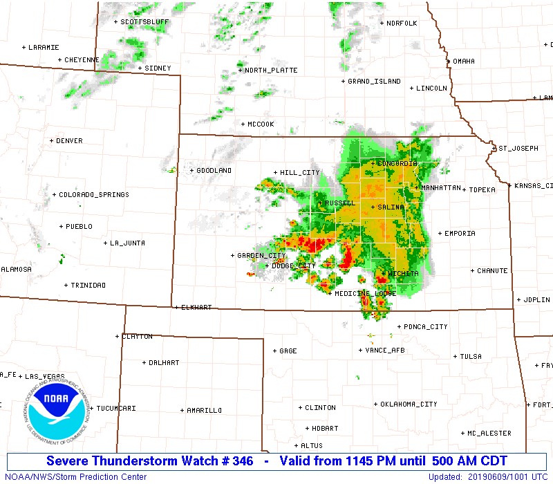
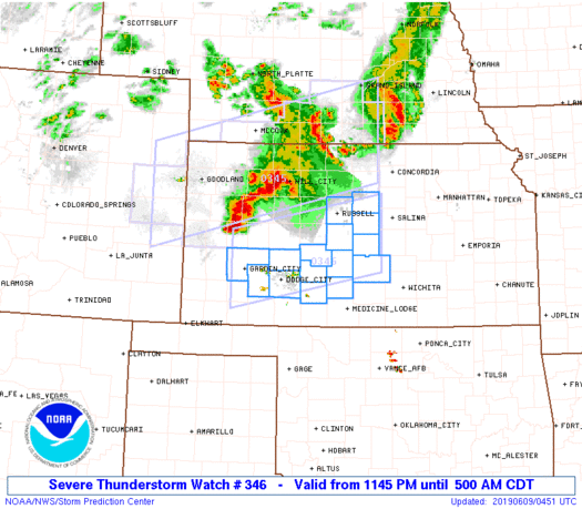
Severe Thunderstorm Watch Number 346
NWS Storm Prediction Center Norman OK
1145 PM CDT Sat Jun 8 2019
The NWS Storm Prediction Center has issued a
* Severe Thunderstorm Watch for portions of
Southwest to central Kansas
* Effective this Saturday night and Sunday morning from 1145 PM
until 500 AM CDT.
* Primary threats include...
Scattered damaging winds and isolated significant gusts to 75
mph possible
Isolated large hail events to 1.5 inches in diameter possible
SUMMARY...Organized thunderstorm cluster over west-central Kansas
should persist and track east-southeast into portions of southwest
and central Kansas through predawn. Severe wind gusts are the
primary hazard.
The severe thunderstorm watch area is approximately along and 45
statute miles north and south of a line from 15 miles west of Garden
City KS to 55 miles east southeast of Russell KS. For a complete
depiction of the watch see the associated watch outline update
(WOUS64 KWNS WOU6).
PRECAUTIONARY/PREPAREDNESS ACTIONS...
REMEMBER...A Severe Thunderstorm Watch means conditions are
favorable for severe thunderstorms in and close to the watch area.
Persons in these areas should be on the lookout for threatening
weather conditions and listen for later statements and possible
warnings. Severe thunderstorms can and occasionally do produce
tornadoes.
&&
OTHER WATCH INFORMATION...CONTINUE...WW 345...
AVIATION...A few severe thunderstorms with hail surface and aloft to
1.5 inches. Extreme turbulence and surface wind gusts to 65 knots. A
few cumulonimbi with maximum tops to 600. Mean storm motion vector
29030.
...Grams
 Note:
The Aviation Watch (SAW) product is an approximation to the watch area.
The actual watch is depicted by the shaded areas.
Note:
The Aviation Watch (SAW) product is an approximation to the watch area.
The actual watch is depicted by the shaded areas.
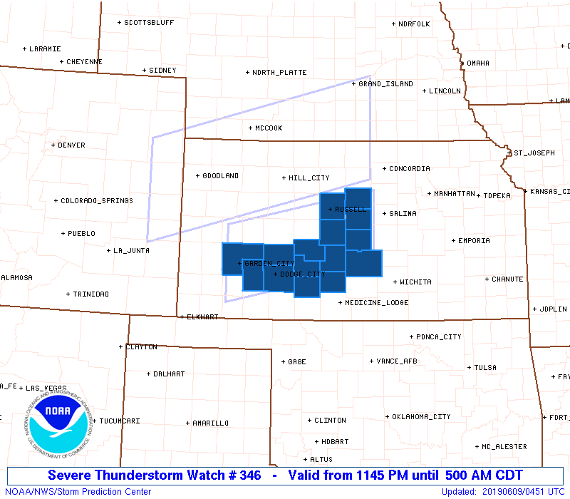
   SAW6
   WW 346 SEVERE TSTM KS 090445Z - 091000Z
   AXIS..45 STATUTE MILES NORTH AND SOUTH OF LINE..
   15W GCK/GARDEN CITY KS/ - 55ESE RSL/RUSSELL KS/
   ..AVIATION COORDS.. 40NM N/S /13W GCK - 26SSW SLN/
   HAIL SURFACE AND ALOFT..1.5 INCHES. WIND GUSTS..65 KNOTS.
   MAX TOPS TO 600. MEAN STORM MOTION VECTOR 29030.

   LAT...LON 38580100 39209787 37909787 37270100

   THIS IS AN APPROXIMATION TO THE WATCH AREA.  FOR A
   COMPLETE DEPICTION OF THE WATCH SEE WOUS64 KWNS
   FOR WOU6.
Watch 346 Status Report Messages:
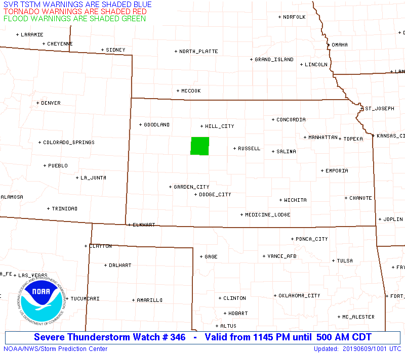
STATUS REPORT #5 ON WW 346

VALID 090935Z - 091040Z

SEVERE WEATHER THREAT CONTINUES RIGHT OF A LINE FROM 30 NNE P28
TO 35 WNW HUT TO 15 N HUT.

..GOSS..06/09/19

ATTN...WFO...ICT...DDC...

&&

STATUS REPORT FOR WS 346

SEVERE WEATHER THREAT CONTINUES FOR THE FOLLOWING AREAS

KSC015-017-079-113-115-155-159-173-091040-

KS
.    KANSAS COUNTIES INCLUDED ARE

BUTLER		     CHASE		 HARVEY
MCPHERSON	     MARION		 RENO
RICE		     SEDGWICK
$$


THE WATCH STATUS MESSAGE IS FOR GUIDANCE PURPOSES ONLY.  PLEASE
REFER TO WATCH COUNTY NOTIFICATION STATEMENTS FOR OFFICIAL
INFORMATION ON COUNTIES...INDEPENDENT CITIES AND MARINE ZONES
CLEARED FROM SEVERE THUNDERSTORM AND TORNADO WATCHES.
$$

STATUS REPORT #4 ON WW 346

VALID 090935Z - 091040Z

SEVERE WEATHER THREAT CONTINUES RIGHT OF A LINE FROM 30 NNE P28
TO 35 WNW HUT TO 15 N HUT.

..GOSS..06/09/19

ATTN...WFO...ICT...DDC...

&&

STATUS REPORT FOR WS 346

SEVERE WEATHER THREAT CONTINUES FOR THE FOLLOWING AREAS

KSC015-017-079-113-115-155-159-173-091040-

KS
.    KANSAS COUNTIES INCLUDED ARE

BUTLER		     CHASE		 HARVEY
MCPHERSON	     MARION		 RENO
RICE		     SEDGWICK
$$


THE WATCH STATUS MESSAGE IS FOR GUIDANCE PURPOSES ONLY.  PLEASE
REFER TO WATCH COUNTY NOTIFICATION STATEMENTS FOR OFFICIAL
INFORMATION ON COUNTIES...INDEPENDENT CITIES AND MARINE ZONES
CLEARED FROM SEVERE THUNDERSTORM AND TORNADO WATCHES.
$$

STATUS REPORT #3 ON WW 346

VALID 090745Z - 090840Z

SEVERE WEATHER THREAT CONTINUES RIGHT OF A LINE FROM 20 W GCK TO
40 WSW RSL TO 30 W RSL.

..GOSS..06/09/19

ATTN...WFO...ICT...DDC...

&&

STATUS REPORT FOR WS 346

SEVERE WEATHER THREAT CONTINUES FOR THE FOLLOWING AREAS

KSC009-047-053-055-057-069-083-097-105-113-145-151-155-159-167-
169-185-090840-

KS
.    KANSAS COUNTIES INCLUDED ARE

BARTON		     EDWARDS		 ELLSWORTH
FINNEY		     FORD		 GRAY
HODGEMAN	     KIOWA		 LINCOLN
MCPHERSON	     PAWNEE		 PRATT
RENO		     RICE		 RUSSELL
SALINE		     STAFFORD
$$


THE WATCH STATUS MESSAGE IS FOR GUIDANCE PURPOSES ONLY.  PLEASE
REFER TO WATCH COUNTY NOTIFICATION STATEMENTS FOR OFFICIAL
INFORMATION ON COUNTIES...INDEPENDENT CITIES AND MARINE ZONES
CLEARED FROM SEVERE THUNDERSTORM AND TORNADO WATCHES.
$$

STATUS REPORT #2 ON WW 346

VALID 090645Z - 090740Z

SEVERE WEATHER THREAT CONTINUES RIGHT OF A LINE FROM 15 W GCK TO
40 WSW RSL TO 30 W RSL.

..GOSS..06/09/19

ATTN...WFO...ICT...DDC...

&&

STATUS REPORT FOR WS 346

SEVERE WEATHER THREAT CONTINUES FOR THE FOLLOWING AREAS

KSC009-047-053-055-057-069-083-097-105-113-145-151-155-159-167-
169-185-090740-

KS
.    KANSAS COUNTIES INCLUDED ARE

BARTON		     EDWARDS		 ELLSWORTH
FINNEY		     FORD		 GRAY
HODGEMAN	     KIOWA		 LINCOLN
MCPHERSON	     PAWNEE		 PRATT
RENO		     RICE		 RUSSELL
SALINE		     STAFFORD
$$


THE WATCH STATUS MESSAGE IS FOR GUIDANCE PURPOSES ONLY.  PLEASE
REFER TO WATCH COUNTY NOTIFICATION STATEMENTS FOR OFFICIAL
INFORMATION ON COUNTIES...INDEPENDENT CITIES AND MARINE ZONES
CLEARED FROM SEVERE THUNDERSTORM AND TORNADO WATCHES.
$$

STATUS REPORT #1 ON WW 346

VALID 090540Z - 090640Z

THE SEVERE WEATHER THREAT CONTINUES ACROSS THE ENTIRE WATCH AREA.

..GOSS..06/09/19

ATTN...WFO...ICT...DDC...

&&

STATUS REPORT FOR WS 346

SEVERE WEATHER THREAT CONTINUES FOR THE FOLLOWING AREAS

KSC009-047-053-055-057-069-083-097-105-145-151-155-159-167-185-
090640-

KS
.    KANSAS COUNTIES INCLUDED ARE

BARTON		     EDWARDS		 ELLSWORTH
FINNEY		     FORD		 GRAY
HODGEMAN	     KIOWA		 LINCOLN
PAWNEE		     PRATT		 RENO
RICE		     RUSSELL		 STAFFORD
$$


THE WATCH STATUS MESSAGE IS FOR GUIDANCE PURPOSES ONLY.  PLEASE
REFER TO WATCH COUNTY NOTIFICATION STATEMENTS FOR OFFICIAL
INFORMATION ON COUNTIES...INDEPENDENT CITIES AND MARINE ZONES
CLEARED FROM SEVERE THUNDERSTORM AND TORNADO WATCHES.
$$
Note:
Click for Complete Product Text.
Tornadoes
Probability of 2 or more tornadoes
|
Low (10%)
|
Probability of 1 or more strong (EF2-EF5) tornadoes
|
Low (5%)
|
Wind
Probability of 10 or more severe wind events
|
Mod (40%)
|
Probability of 1 or more wind events > 65 knots
|
Mod (30%)
|
Hail
Probability of 10 or more severe hail events
|
Low (20%)
|
Probability of 1 or more hailstones > 2 inches
|
Low (10%)
|
Combined Severe Hail/Wind
Probability of 6 or more combined severe hail/wind events
|
Mod (60%)
|
For each watch, probabilities for particular events inside the watch
(listed above in each table) are determined by the issuing forecaster.
The "Low" category contains probability values ranging from less than 2%
to 20% (EF2-EF5 tornadoes), less than 5% to 20% (all other probabilities),
"Moderate" from 30% to 60%, and "High" from 70% to greater than 95%.
High values are bolded and lighter in color to provide awareness of
an increased threat for a particular event.


 @NWSSPC