 Note:
The expiration time in the watch graphic is amended if the watch is
replaced, cancelled or extended.
Note:
Note:
The expiration time in the watch graphic is amended if the watch is
replaced, cancelled or extended.
Note: Click for
Watch Status Reports.
SEL7
URGENT - IMMEDIATE BROADCAST REQUESTED
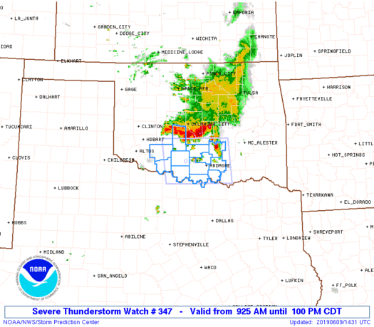
Severe Thunderstorm Watch Number 347
NWS Storm Prediction Center Norman OK
925 AM CDT Sun Jun 9 2019
The NWS Storm Prediction Center has issued a
* Severe Thunderstorm Watch for portions of
South central Oklahoma
* Effective this Sunday morning and afternoon from 925 AM until
100 PM CDT.
* Primary threats include...
Scattered damaging winds and isolated significant gusts to 75
mph possible
Scattered large hail events to 1.5 inches in diameter possible
SUMMARY...A small convective system, though initially elevated, is
producing a substantial cold pool and downdraft with damaging gusts,
as well as large hail. The storm environment could support the
storms persisting at least to the Red River through midday.
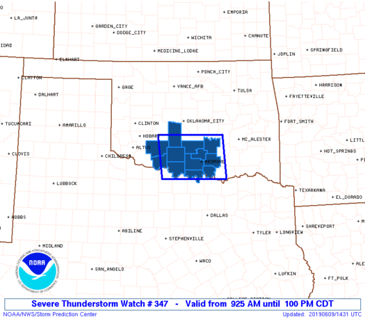
The severe thunderstorm watch area is approximately along and 60
statute miles east and west of a line from 55 miles north northwest
of Ardmore OK to 35 miles south southwest of Ardmore OK. For a
complete depiction of the watch see the associated watch outline
update (WOUS64 KWNS WOU7).
PRECAUTIONARY/PREPAREDNESS ACTIONS...
REMEMBER...A Severe Thunderstorm Watch means conditions are
favorable for severe thunderstorms in and close to the watch area.
Persons in these areas should be on the lookout for threatening
weather conditions and listen for later statements and possible
warnings. Severe thunderstorms can and occasionally do produce
tornadoes.
&&
AVIATION...A few severe thunderstorms with hail surface and aloft to
1.5 inches. Extreme turbulence and surface wind gusts to 65 knots. A
few cumulonimbi with maximum tops to 550. Mean storm motion vector
33035.
...Thompson
   SEL7

   URGENT - IMMEDIATE BROADCAST REQUESTED
   Severe Thunderstorm Watch Number 347
   NWS Storm Prediction Center Norman OK
   925 AM CDT Sun Jun 9 2019

   The NWS Storm Prediction Center has issued a

   * Severe Thunderstorm Watch for portions of
     South central Oklahoma

   * Effective this Sunday morning and afternoon from 925 AM until
     100 PM CDT.

   * Primary threats include...
     Scattered damaging winds and isolated significant gusts to 75
       mph possible
     Scattered large hail events to 1.5 inches in diameter possible

   SUMMARY...A small convective system, though initially elevated, is
   producing a substantial cold pool and downdraft with damaging gusts,
   as well as large hail.  The storm environment could support the
   storms persisting at least to the Red River through midday.

   The severe thunderstorm watch area is approximately along and 60
   statute miles east and west of a line from 55 miles north northwest
   of Ardmore OK to 35 miles south southwest of Ardmore OK. For a
   complete depiction of the watch see the associated watch outline
   update (WOUS64 KWNS WOU7).

   PRECAUTIONARY/PREPAREDNESS ACTIONS...

   REMEMBER...A Severe Thunderstorm Watch means conditions are
   favorable for severe thunderstorms in and close to the watch area.
   Persons in these areas should be on the lookout for threatening
   weather conditions and listen for later statements and possible
   warnings. Severe thunderstorms can and occasionally do produce
   tornadoes.

   &&

   AVIATION...A few severe thunderstorms with hail surface and aloft to
   1.5 inches. Extreme turbulence and surface wind gusts to 65 knots. A
   few cumulonimbi with maximum tops to 550. Mean storm motion vector
   33035.

   ...Thompson
 Note:
The Aviation Watch (SAW) product is an approximation to the watch area.
The actual watch is depicted by the shaded areas.
Note:
The Aviation Watch (SAW) product is an approximation to the watch area.
The actual watch is depicted by the shaded areas.
   SAW7
   WW 347 SEVERE TSTM OK 091425Z - 091800Z
   AXIS..60 STATUTE MILES EAST AND WEST OF LINE..
   55NNW ADM/ARDMORE OK/ - 35SSW ADM/ARDMORE OK/
   ..AVIATION COORDS.. 50NM E/W /23SSE OKC - 24S ADM/
   HAIL SURFACE AND ALOFT..1.5 INCHES. WIND GUSTS..65 KNOTS.
   MAX TOPS TO 550. MEAN STORM MOTION VECTOR 33035.

   LAT...LON 35029633 33819620 33819830 35029844

   THIS IS AN APPROXIMATION TO THE WATCH AREA.  FOR A
   COMPLETE DEPICTION OF THE WATCH SEE WOUS64 KWNS
   FOR WOU7.
Watch 347 Status Report Messages:
STATUS REPORT #3 ON WW 347

VALID 091735Z - 091840Z

SEVERE WEATHER THREAT CONTINUES RIGHT OF A LINE FROM 45 ESE SPS
TO 20 S ADM TO 15 NE DUA.

..GUYER..06/09/19

ATTN...WFO...OUN...

&&

STATUS REPORT FOR WS 347

SEVERE WEATHER THREAT CONTINUES FOR THE FOLLOWING AREAS

OKC085-095-091840-

OK
.    OKLAHOMA COUNTIES INCLUDED ARE

LOVE		     MARSHALL
$$


THE WATCH STATUS MESSAGE IS FOR GUIDANCE PURPOSES ONLY.  PLEASE
REFER TO WATCH COUNTY NOTIFICATION STATEMENTS FOR OFFICIAL
INFORMATION ON COUNTIES...INDEPENDENT CITIES AND MARINE ZONES
CLEARED FROM SEVERE THUNDERSTORM AND TORNADO WATCHES.
$$

STATUS REPORT #2 ON WW 347

VALID 091630Z - 091740Z

SEVERE WEATHER THREAT CONTINUES RIGHT OF A LINE FROM 25 NNE SPS
TO 35 WNW ADM TO 20 NNE ADM TO 35 SW MLC.

FOR ADDITIONAL INFORMATION SEE MESOSCALE DISCUSSION 1039

..GUYER..06/09/19

ATTN...WFO...OUN...

&&

STATUS REPORT FOR WS 347

SEVERE WEATHER THREAT CONTINUES FOR THE FOLLOWING AREAS

OKC019-033-067-069-085-095-099-123-137-091740-

OK
.    OKLAHOMA COUNTIES INCLUDED ARE

CARTER		     COTTON		 JEFFERSON
JOHNSTON	     LOVE		 MARSHALL
MURRAY		     PONTOTOC		 STEPHENS
$$


THE WATCH STATUS MESSAGE IS FOR GUIDANCE PURPOSES ONLY.  PLEASE
REFER TO WATCH COUNTY NOTIFICATION STATEMENTS FOR OFFICIAL
INFORMATION ON COUNTIES...INDEPENDENT CITIES AND MARINE ZONES
CLEARED FROM SEVERE THUNDERSTORM AND TORNADO WATCHES.
$$

STATUS REPORT #1 ON WW 347

VALID 091545Z - 091640Z

SEVERE WEATHER THREAT CONTINUES RIGHT OF A LINE FROM 25 N FSI TO
20 SSE CHK TO 35 ESE CHK TO 40 SE OKC.

FOR ADDITIONAL INFORMATION SEE MESOSCALE DISCUSSION 1039

..GUYER..06/09/19

ATTN...WFO...OUN...

&&

STATUS REPORT FOR WS 347

SEVERE WEATHER THREAT CONTINUES FOR THE FOLLOWING AREAS

OKC019-031-033-049-067-069-085-095-099-123-137-091640-

OK
.    OKLAHOMA COUNTIES INCLUDED ARE

CARTER		     COMANCHE		 COTTON
GARVIN		     JEFFERSON		 JOHNSTON
LOVE		     MARSHALL		 MURRAY
PONTOTOC	     STEPHENS
$$


THE WATCH STATUS MESSAGE IS FOR GUIDANCE PURPOSES ONLY.  PLEASE
REFER TO WATCH COUNTY NOTIFICATION STATEMENTS FOR OFFICIAL
INFORMATION ON COUNTIES...INDEPENDENT CITIES AND MARINE ZONES
CLEARED FROM SEVERE THUNDERSTORM AND TORNADO WATCHES.
$$
Note:
Click for Complete Product Text.
Tornadoes
Probability of 2 or more tornadoes
|
Low (10%)
|
Probability of 1 or more strong (EF2-EF5) tornadoes
|
Low (<2%)
|
Wind
Probability of 10 or more severe wind events
|
Mod (40%)
|
Probability of 1 or more wind events > 65 knots
|
Mod (30%)
|
Hail
Probability of 10 or more severe hail events
|
Mod (40%)
|
Probability of 1 or more hailstones > 2 inches
|
Low (20%)
|
Combined Severe Hail/Wind
Probability of 6 or more combined severe hail/wind events
|
High (70%)
|
For each watch, probabilities for particular events inside the watch
(listed above in each table) are determined by the issuing forecaster.
The "Low" category contains probability values ranging from less than 2%
to 20% (EF2-EF5 tornadoes), less than 5% to 20% (all other probabilities),
"Moderate" from 30% to 60%, and "High" from 70% to greater than 95%.
High values are bolded and lighter in color to provide awareness of
an increased threat for a particular event.


 @NWSSPC


