 Note:
The expiration time in the watch graphic is amended if the watch is
replaced, cancelled or extended.
Note:
Note:
The expiration time in the watch graphic is amended if the watch is
replaced, cancelled or extended.
Note: Click for
Watch Status Reports.
SEL2
URGENT - IMMEDIATE BROADCAST REQUESTED
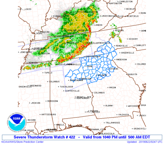
Severe Thunderstorm Watch Number 422
NWS Storm Prediction Center Norman OK
1040 PM EDT Fri Jun 21 2019
The NWS Storm Prediction Center has issued a
* Severe Thunderstorm Watch for portions of
northeast Alabama
northern Georgia
western North Carolina
Upstate South Carolina
* Effective this Friday night and Saturday morning from 1040 PM
until 500 AM EDT.
* Primary threats include...
Scattered damaging wind gusts to 70 mph possible
SUMMARY...Strong to severe thunderstorm activity is expected to be
maintained into the overnight hours along the southeastward
advancing, leading edge of cool outflow produced by the storms,
which may continue to be accompanied by a risk for potential
damaging wind gusts.
The severe thunderstorm watch area is approximately along and 60
statute miles north and south of a line from 20 miles west northwest
of Birmingham AL to 40 miles north of Athens GA. For a complete
depiction of the watch see the associated watch outline update
(WOUS64 KWNS WOU2).
PRECAUTIONARY/PREPAREDNESS ACTIONS...
REMEMBER...A Severe Thunderstorm Watch means conditions are
favorable for severe thunderstorms in and close to the watch area.
Persons in these areas should be on the lookout for threatening
weather conditions and listen for later statements and possible
warnings. Severe thunderstorms can and occasionally do produce
tornadoes.
&&
OTHER WATCH INFORMATION...CONTINUE...WW 419...WW 420...WW 421...
AVIATION...A few severe thunderstorms with hail surface and aloft to
1 inch. Extreme turbulence and surface wind gusts to 60 knots. A few
cumulonimbi with maximum tops to 500. Mean storm motion vector
31035.
...Kerr

   SEL2

   URGENT - IMMEDIATE BROADCAST REQUESTED
   Severe Thunderstorm Watch Number 422
   NWS Storm Prediction Center Norman OK
   1040 PM EDT Fri Jun 21 2019

   The NWS Storm Prediction Center has issued a

   * Severe Thunderstorm Watch for portions of
     northeast Alabama
     northern Georgia
     western North Carolina
     Upstate South Carolina

   * Effective this Friday night and Saturday morning from 1040 PM
     until 500 AM EDT.

   * Primary threats include...
     Scattered damaging wind gusts to 70 mph possible

   SUMMARY...Strong to severe thunderstorm activity is expected to be
   maintained into the overnight hours along the southeastward
   advancing, leading edge of cool outflow produced by the storms,
   which may continue to be accompanied by a risk for potential
   damaging wind gusts.

   The severe thunderstorm watch area is approximately along and 60
   statute miles north and south of a line from 20 miles west northwest
   of Birmingham AL to 40 miles north of Athens GA. For a complete
   depiction of the watch see the associated watch outline update
   (WOUS64 KWNS WOU2).

   PRECAUTIONARY/PREPAREDNESS ACTIONS...

   REMEMBER...A Severe Thunderstorm Watch means conditions are
   favorable for severe thunderstorms in and close to the watch area.
   Persons in these areas should be on the lookout for threatening
   weather conditions and listen for later statements and possible
   warnings. Severe thunderstorms can and occasionally do produce
   tornadoes.

   &&

   OTHER WATCH INFORMATION...CONTINUE...WW 419...WW 420...WW 421...

   AVIATION...A few severe thunderstorms with hail surface and aloft to
   1 inch. Extreme turbulence and surface wind gusts to 60 knots. A few
   cumulonimbi with maximum tops to 500. Mean storm motion vector
   31035.

   ...Kerr
 Note:
The Aviation Watch (SAW) product is an approximation to the watch area.
The actual watch is depicted by the shaded areas.
Note:
The Aviation Watch (SAW) product is an approximation to the watch area.
The actual watch is depicted by the shaded areas.
SAW2
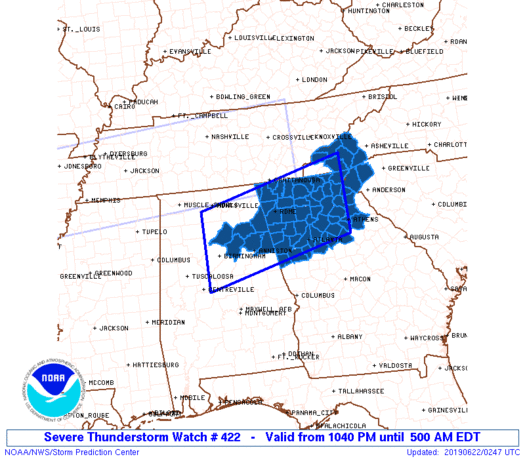
WW 422 SEVERE TSTM AL GA NC SC 220240Z - 220900Z
AXIS..60 STATUTE MILES NORTH AND SOUTH OF LINE..
20WNW BHM/BIRMINGHAM AL/ - 40N AHN/ATHENS GA/
..AVIATION COORDS.. 50NM N/S /9W VUZ - 10S ODF/
HAIL SURFACE AND ALOFT..1 INCH. WIND GUSTS..60 KNOTS.
MAX TOPS TO 500. MEAN STORM MOTION VECTOR 31035.
LAT...LON 34548706 35408333 33658333 32818706
THIS IS AN APPROXIMATION TO THE WATCH AREA. FOR A
COMPLETE DEPICTION OF THE WATCH SEE WOUS64 KWNS
FOR WOU2.
Watch 422 Status Report Messages:
STATUS REPORT #3 ON WW 422

VALID 220650Z - 220740Z

SEVERE WEATHER THREAT CONTINUES RIGHT OF A LINE FROM 20 NNW LGC
TO ATL TO 25 WSW AHN TO 10 NNE AHN.

..MOSIER..06/22/19

ATTN...WFO...BMX...FFC...GSP...

&&

STATUS REPORT FOR WS 422

SEVERE WEATHER THREAT CONTINUES FOR THE FOLLOWING AREAS

GAC059-063-077-105-113-149-151-211-217-219-221-247-297-220740-

GA
.    GEORGIA COUNTIES INCLUDED ARE

CLARKE		     CLAYTON		 COWETA
ELBERT		     FAYETTE		 HEARD
HENRY		     MORGAN		 NEWTON
OCONEE		     OGLETHORPE 	 ROCKDALE
WALTON
$$


SCC001-007-047-220740-

SC
.    SOUTH CAROLINA COUNTIES INCLUDED ARE

ABBEVILLE	     ANDERSON		 GREENWOOD
$$


THE WATCH STATUS MESSAGE IS FOR GUIDANCE PURPOSES ONLY.  PLEASE
REFER TO WATCH COUNTY NOTIFICATION STATEMENTS FOR OFFICIAL
INFORMATION ON COUNTIES...INDEPENDENT CITIES AND MARINE ZONES
CLEARED FROM SEVERE THUNDERSTORM AND TORNADO WATCHES.
$$

STATUS REPORT #2 ON WW 422

VALID 220440Z - 220540Z

SEVERE WEATHER THREAT CONTINUES RIGHT OF A LINE FROM 40 NW BHM TO
25 NE GAD TO 15 NE RMG TO 50 ESE CHA TO 40 SW HSS TO 5 WSW HSS.

..LEITMAN..06/22/19

ATTN...WFO...BMX...FFC...GSP...

&&

STATUS REPORT FOR WS 422

SEVERE WEATHER THREAT CONTINUES FOR THE FOLLOWING AREAS

ALC009-015-019-029-055-115-220540-

AL
.    ALABAMA COUNTIES INCLUDED ARE

BLOUNT		     CALHOUN		 CHEROKEE
CLEBURNE	     ETOWAH		 ST. CLAIR
$$


GAC011-013-015-045-055-057-059-063-067-077-085-089-097-111-113-
115-117-119-121-123-129-135-137-139-143-149-151-157-187-195-211-
217-219-221-223-227-233-241-247-257-281-291-297-311-220540-

GA
.    GEORGIA COUNTIES INCLUDED ARE

BANKS		     BARROW		 BARTOW
CARROLL 	     CHATTOOGA		 CHEROKEE
CLARKE		     CLAYTON		 COBB
COWETA		     DAWSON		 DEKALB
DOUGLAS 	     FANNIN		 FAYETTE
FLOYD		     FORSYTH		 FRANKLIN
FULTON		     GILMER		 GORDON
GWINNETT	     HABERSHAM		 HALL
HARALSON	     HEARD		 HENRY
JACKSON 	     LUMPKIN		 MADISON
MORGAN		     NEWTON		 OCONEE
OGLETHORPE	     PAULDING		 PICKENS
POLK		     RABUN		 ROCKDALE
STEPHENS	     TOWNS		 UNION
WALTON		     WHITE
$$


NCC087-099-113-175-220540-

NC
.    NORTH CAROLINA COUNTIES INCLUDED ARE

HAYWOOD 	     JACKSON		 MACON
TRANSYLVANIA
$$


SCC073-077-220540-

SC
.    SOUTH CAROLINA COUNTIES INCLUDED ARE

OCONEE		     PICKENS
$$


THE WATCH STATUS MESSAGE IS FOR GUIDANCE PURPOSES ONLY.  PLEASE
REFER TO WATCH COUNTY NOTIFICATION STATEMENTS FOR OFFICIAL
INFORMATION ON COUNTIES...INDEPENDENT CITIES AND MARINE ZONES
CLEARED FROM SEVERE THUNDERSTORM AND TORNADO WATCHES.
$$

STATUS REPORT #1 ON WW 422

VALID 220340Z - 220440Z

THE SEVERE WEATHER THREAT CONTINUES ACROSS THE ENTIRE WATCH AREA.

..LEITMAN..06/22/19

ATTN...WFO...BMX...FFC...GSP...

&&

STATUS REPORT FOR WS 422

SEVERE WEATHER THREAT CONTINUES FOR THE FOLLOWING AREAS

ALC009-015-019-029-055-115-220440-

AL
.    ALABAMA COUNTIES INCLUDED ARE

BLOUNT		     CALHOUN		 CHEROKEE
CLEBURNE	     ETOWAH		 ST. CLAIR
$$


GAC011-013-015-045-047-055-057-059-063-067-077-083-085-089-097-
111-113-115-117-119-121-123-129-135-137-139-143-149-151-157-187-
195-211-213-217-219-221-223-227-233-241-247-257-281-291-295-297-
311-313-220440-

GA
.    GEORGIA COUNTIES INCLUDED ARE

BANKS		     BARROW		 BARTOW
CARROLL 	     CATOOSA		 CHATTOOGA
CHEROKEE	     CLARKE		 CLAYTON
COBB		     COWETA		 DADE
DAWSON		     DEKALB		 DOUGLAS
FANNIN		     FAYETTE		 FLOYD
FORSYTH 	     FRANKLIN		 FULTON
GILMER		     GORDON		 GWINNETT
HABERSHAM	     HALL		 HARALSON
HEARD		     HENRY		 JACKSON
LUMPKIN 	     MADISON		 MORGAN
MURRAY		     NEWTON		 OCONEE
OGLETHORPE	     PAULDING		 PICKENS
POLK		     RABUN		 ROCKDALE
STEPHENS	     TOWNS		 UNION
WALKER		     WALTON		 WHITE
WHITFIELD
$$


NCC075-087-099-113-173-175-220440-

NC
.    NORTH CAROLINA COUNTIES INCLUDED ARE

GRAHAM		     HAYWOOD		 JACKSON
MACON		     SWAIN		 TRANSYLVANIA
$$


SCC073-077-220440-

SC
.    SOUTH CAROLINA COUNTIES INCLUDED ARE

OCONEE		     PICKENS
$$


THE WATCH STATUS MESSAGE IS FOR GUIDANCE PURPOSES ONLY.  PLEASE
REFER TO WATCH COUNTY NOTIFICATION STATEMENTS FOR OFFICIAL
INFORMATION ON COUNTIES...INDEPENDENT CITIES AND MARINE ZONES
CLEARED FROM SEVERE THUNDERSTORM AND TORNADO WATCHES.
$$
Note:
Click for Complete Product Text.
Tornadoes
Probability of 2 or more tornadoes
|
Low (<5%)
|
Probability of 1 or more strong (EF2-EF5) tornadoes
|
Low (<2%)
|
Wind
Probability of 10 or more severe wind events
|
Mod (40%)
|
Probability of 1 or more wind events > 65 knots
|
Low (20%)
|
Hail
Probability of 10 or more severe hail events
|
Low (10%)
|
Probability of 1 or more hailstones > 2 inches
|
Low (<5%)
|
Combined Severe Hail/Wind
Probability of 6 or more combined severe hail/wind events
|
Mod (60%)
|
For each watch, probabilities for particular events inside the watch
(listed above in each table) are determined by the issuing forecaster.
The "Low" category contains probability values ranging from less than 2%
to 20% (EF2-EF5 tornadoes), less than 5% to 20% (all other probabilities),
"Moderate" from 30% to 60%, and "High" from 70% to greater than 95%.
High values are bolded and lighter in color to provide awareness of
an increased threat for a particular event.


 @NWSSPC


