 Note:
The expiration time in the watch graphic is amended if the watch is
replaced, cancelled or extended.
Note:
Note:
The expiration time in the watch graphic is amended if the watch is
replaced, cancelled or extended.
Note: Click for
Watch Status Reports.
SEL5
URGENT - IMMEDIATE BROADCAST REQUESTED
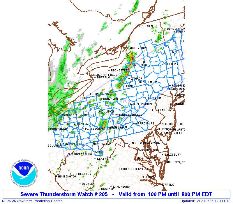
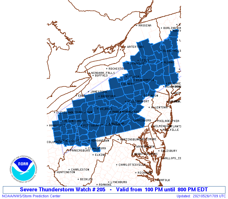
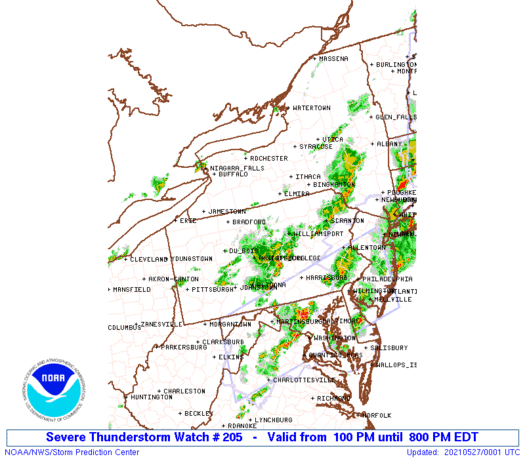
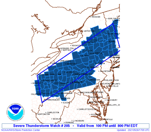
Severe Thunderstorm Watch Number 205
NWS Storm Prediction Center Norman OK
100 PM EDT Wed May 26 2021
The NWS Storm Prediction Center has issued a
* Severe Thunderstorm Watch for portions of
Western Connecticut
Western Massachusetts
Central and Eastern New York
Eastern Ohio
Much of Pennsylvania
Southern Vermont
Northern West Virginia
* Effective this Wednesday afternoon and evening from 100 PM
until 800 PM EDT.
* Primary threats include...
Scattered damaging wind gusts to 70 mph likely
Scattered large hail events to 1 inch in diameter possible
SUMMARY...Scattered thunderstorms will continue to develop through
the afternoon in a warm/humid air mass. The strongest storms will
pose a risk of gusty/damaging wind gusts through early evening.
The severe thunderstorm watch area is approximately along and 75
statute miles north and south of a line from 50 miles south
southwest of Akron OH to 45 miles northeast of Pittsfield MA. For a
complete depiction of the watch see the associated watch outline
update (WOUS64 KWNS WOU5).
PRECAUTIONARY/PREPAREDNESS ACTIONS...
REMEMBER...A Severe Thunderstorm Watch means conditions are
favorable for severe thunderstorms in and close to the watch area.
Persons in these areas should be on the lookout for threatening
weather conditions and listen for later statements and possible
warnings. Severe thunderstorms can and occasionally do produce
tornadoes.
&&
AVIATION...A few severe thunderstorms with hail surface and aloft to
1 inch. Extreme turbulence and surface wind gusts to 60 knots. A few
cumulonimbi with maximum tops to 450. Mean storm motion vector
26035.
...Hart
 Note:
The Aviation Watch (SAW) product is an approximation to the watch area.
The actual watch is depicted by the shaded areas.
Note:
The Aviation Watch (SAW) product is an approximation to the watch area.
The actual watch is depicted by the shaded areas.
   SAW5
   WW 205 SEVERE TSTM CT MA NY OH PA VT WV 261700Z - 270000Z
   AXIS..75 STATUTE MILES NORTH AND SOUTH OF LINE..
   50SSW CAK/AKRON OH/ - 45NE PSF/PITTSFIELD MA/
   ..AVIATION COORDS.. 65NM N/S /37E APE - 50E ALB/
   HAIL SURFACE AND ALOFT..1 INCH. WIND GUSTS..60 KNOTS.
   MAX TOPS TO 450. MEAN STORM MOTION VECTOR 26035.

   LAT...LON 41348179 43977267 41807267 39168179

   THIS IS AN APPROXIMATION TO THE WATCH AREA.  FOR A
   COMPLETE DEPICTION OF THE WATCH SEE WOUS64 KWNS
   FOR WOU5.
Watch 205 Status Report Messages:
STATUS REPORT #3 ON WW 205

VALID 262205Z - 262340Z

SEVERE WEATHER THREAT CONTINUES RIGHT OF A LINE FROM 20 WNW MGW
TO 35 SSW DUJ TO 40 NW IPT TO 20 SSW ELM TO 15 WSW SYR.

..WENDT..05/26/21

ATTN...WFO...ALY...BGM...PBZ...CLE...CTP...BTV...

&&

STATUS REPORT FOR WS 205

SEVERE WEATHER THREAT CONTINUES FOR THE FOLLOWING AREAS

CTC005-262340-

CT
.    CONNECTICUT COUNTIES INCLUDED ARE

LITCHFIELD
$$


MAC003-262340-

MA
.    MASSACHUSETTS COUNTIES INCLUDED ARE

BERKSHIRE
$$


NYC001-007-017-021-023-025-027-035-039-041-043-053-057-065-067-
077-083-091-093-095-105-107-109-111-113-115-262340-

NY
.    NEW YORK COUNTIES INCLUDED ARE

ALBANY		     BROOME		 CHENANGO
COLUMBIA	     CORTLAND		 DELAWARE
DUTCHESS	     FULTON		 GREENE
HAMILTON	     HERKIMER		 MADISON
MONTGOMERY	     ONEIDA		 ONONDAGA
OTSEGO		     RENSSELAER 	 SARATOGA
SCHENECTADY	     SCHOHARIE		 SULLIVAN
TIOGA		     TOMPKINS		 ULSTER
WARREN		     WASHINGTON
$$


PAC001-009-013-015-021-027-033-035-037-041-043-051-055-057-061-
063-067-069-071-075-079-081-087-093-097-099-103-107-109-111-113-
115-119-127-129-131-133-262340-

PA
.    PENNSYLVANIA COUNTIES INCLUDED ARE

ADAMS		     BEDFORD		 BLAIR
BRADFORD	     CAMBRIA		 CENTRE
CLEARFIELD	     CLINTON		 COLUMBIA
CUMBERLAND	     DAUPHIN		 FAYETTE
FRANKLIN	     FULTON		 HUNTINGDON
INDIANA 	     JUNIATA		 LACKAWANNA
LANCASTER	     LEBANON		 LUZERNE
LYCOMING	     MIFFLIN		 MONTOUR
NORTHUMBERLAND	     PERRY		 PIKE
SCHUYLKILL	     SNYDER		 SOMERSET
SULLIVAN	     SUSQUEHANNA	 UNION
WAYNE		     WESTMORELAND	 WYOMING
YORK
$$


VTC003-025-262340-

VT
.    VERMONT COUNTIES INCLUDED ARE

BENNINGTON	     WINDHAM
$$


WVC077-093-262340-

WV
.    WEST VIRGINIA COUNTIES INCLUDED ARE

PRESTON 	     TUCKER
$$


THE WATCH STATUS MESSAGE IS FOR GUIDANCE PURPOSES ONLY.  PLEASE
REFER TO WATCH COUNTY NOTIFICATION STATEMENTS FOR OFFICIAL
INFORMATION ON COUNTIES...INDEPENDENT CITIES AND MARINE ZONES
CLEARED FROM SEVERE THUNDERSTORM AND TORNADO WATCHES.
$$

STATUS REPORT #2 ON WW 205

VALID 262030Z - 262140Z

SEVERE WEATHER THREAT CONTINUES RIGHT OF A LINE FROM 15 ESE PKB
TO 25 SW DUJ TO 25 ESE BFD TO 25 SSE ROC.

..LEITMAN..05/26/21

ATTN...WFO...ALY...BGM...PBZ...CLE...CTP...BTV...

&&

STATUS REPORT FOR WS 205

SEVERE WEATHER THREAT CONTINUES FOR THE FOLLOWING AREAS

CTC005-262140-

CT
.    CONNECTICUT COUNTIES INCLUDED ARE

LITCHFIELD
$$


MAC003-262140-

MA
.    MASSACHUSETTS COUNTIES INCLUDED ARE

BERKSHIRE
$$


NYC001-007-015-017-021-023-025-027-035-039-041-043-053-057-065-
067-077-083-091-093-095-097-101-105-107-109-111-113-115-
262140-

NY
.    NEW YORK COUNTIES INCLUDED ARE

ALBANY		     BROOME		 CHEMUNG
CHENANGO	     COLUMBIA		 CORTLAND
DELAWARE	     DUTCHESS		 FULTON
GREENE		     HAMILTON		 HERKIMER
MADISON 	     MONTGOMERY 	 ONEIDA
ONONDAGA	     OTSEGO		 RENSSELAER
SARATOGA	     SCHENECTADY	 SCHOHARIE
SCHUYLER	     STEUBEN		 SULLIVAN
TIOGA		     TOMPKINS		 ULSTER
WARREN		     WASHINGTON
$$


PAC001-003-005-009-013-015-021-023-027-033-035-037-041-043-047-
051-055-057-059-061-063-065-067-069-071-075-079-081-087-093-097-
099-103-105-107-109-111-113-115-117-119-125-127-129-131-133-
262140-

PA
.    PENNSYLVANIA COUNTIES INCLUDED ARE

ADAMS		     ALLEGHENY		 ARMSTRONG
BEDFORD 	     BLAIR		 BRADFORD
CAMBRIA 	     CAMERON		 CENTRE
CLEARFIELD	     CLINTON		 COLUMBIA
CUMBERLAND	     DAUPHIN		 ELK
FAYETTE 	     FRANKLIN		 FULTON
GREENE		     HUNTINGDON 	 INDIANA
JEFFERSON	     JUNIATA		 LACKAWANNA
LANCASTER	     LEBANON		 LUZERNE
LYCOMING	     MIFFLIN		 MONTOUR
NORTHUMBERLAND	     PERRY		 PIKE
POTTER		     SCHUYLKILL 	 SNYDER
SOMERSET	     SULLIVAN		 SUSQUEHANNA
TIOGA		     UNION		 WASHINGTON
WAYNE		     WESTMORELAND	 WYOMING
YORK
$$


VTC003-017-021-025-027-262140-

VT
.    VERMONT COUNTIES INCLUDED ARE

BENNINGTON	     ORANGE		 RUTLAND
WINDHAM 	     WINDSOR
$$


WVC049-061-077-093-103-262140-

WV
.    WEST VIRGINIA COUNTIES INCLUDED ARE

MARION		     MONONGALIA 	 PRESTON
TUCKER		     WETZEL
$$


THE WATCH STATUS MESSAGE IS FOR GUIDANCE PURPOSES ONLY.  PLEASE
REFER TO WATCH COUNTY NOTIFICATION STATEMENTS FOR OFFICIAL
INFORMATION ON COUNTIES...INDEPENDENT CITIES AND MARINE ZONES
CLEARED FROM SEVERE THUNDERSTORM AND TORNADO WATCHES.
$$

STATUS REPORT #1 ON WW 205

VALID 261925Z - 262040Z

SEVERE WEATHER THREAT CONTINUES RIGHT OF A LINE FROM 15 S PKB TO
25 NW PIT TO 30 NNW DUJ TO 30 S BUF.

..LEITMAN..05/26/21

ATTN...WFO...ALY...BGM...PBZ...CLE...CTP...BTV...

&&

STATUS REPORT FOR WS 205

SEVERE WEATHER THREAT CONTINUES FOR THE FOLLOWING AREAS

CTC005-262040-

CT
.    CONNECTICUT COUNTIES INCLUDED ARE

LITCHFIELD
$$


MAC003-262040-

MA
.    MASSACHUSETTS COUNTIES INCLUDED ARE

BERKSHIRE
$$


NYC001-007-015-017-021-023-025-027-035-039-041-043-053-057-065-
067-077-083-091-093-095-097-101-105-107-109-111-113-115-
262040-

NY
.    NEW YORK COUNTIES INCLUDED ARE

ALBANY		     BROOME		 CHEMUNG
CHENANGO	     COLUMBIA		 CORTLAND
DELAWARE	     DUTCHESS		 FULTON
GREENE		     HAMILTON		 HERKIMER
MADISON 	     MONTGOMERY 	 ONEIDA
ONONDAGA	     OTSEGO		 RENSSELAER
SARATOGA	     SCHENECTADY	 SCHOHARIE
SCHUYLER	     STEUBEN		 SULLIVAN
TIOGA		     TOMPKINS		 ULSTER
WARREN		     WASHINGTON
$$


OHC013-081-111-262040-

OH
.    OHIO COUNTIES INCLUDED ARE

BELMONT 	     JEFFERSON		 MONROE
$$


PAC001-003-005-007-009-013-015-019-021-023-027-031-033-035-037-
041-043-047-051-053-055-057-059-061-063-065-067-069-071-075-079-
081-083-087-093-097-099-103-105-107-109-111-113-115-117-119-125-
127-129-131-133-262040-

PA
.    PENNSYLVANIA COUNTIES INCLUDED ARE

ADAMS		     ALLEGHENY		 ARMSTRONG
BEAVER		     BEDFORD		 BLAIR
BRADFORD	     BUTLER		 CAMBRIA
CAMERON 	     CENTRE		 CLARION
CLEARFIELD	     CLINTON		 COLUMBIA
CUMBERLAND	     DAUPHIN		 ELK
FAYETTE 	     FOREST		 FRANKLIN
FULTON		     GREENE		 HUNTINGDON
INDIANA 	     JEFFERSON		 JUNIATA
LACKAWANNA	     LANCASTER		 LEBANON
LUZERNE 	     LYCOMING		 MCKEAN
MIFFLIN 	     MONTOUR		 NORTHUMBERLAND
PERRY		     PIKE		 POTTER
SCHUYLKILL	     SNYDER		 SOMERSET
SULLIVAN	     SUSQUEHANNA	 TIOGA
UNION		     WASHINGTON 	 WAYNE
WESTMORELAND	     WYOMING		 YORK
$$


VTC003-017-021-025-027-262040-

VT
.    VERMONT COUNTIES INCLUDED ARE

BENNINGTON	     ORANGE		 RUTLAND
WINDHAM 	     WINDSOR
$$


WVC009-029-049-051-061-069-077-093-103-262040-

WV
.    WEST VIRGINIA COUNTIES INCLUDED ARE

BROOKE		     HANCOCK		 MARION
MARSHALL	     MONONGALIA 	 OHIO
PRESTON 	     TUCKER		 WETZEL
$$


THE WATCH STATUS MESSAGE IS FOR GUIDANCE PURPOSES ONLY.  PLEASE
REFER TO WATCH COUNTY NOTIFICATION STATEMENTS FOR OFFICIAL
INFORMATION ON COUNTIES...INDEPENDENT CITIES AND MARINE ZONES
CLEARED FROM SEVERE THUNDERSTORM AND TORNADO WATCHES.
$$
Note:
Click for Complete Product Text.
Tornadoes
Probability of 2 or more tornadoes
|
Low (10%)
|
Probability of 1 or more strong (EF2-EF5) tornadoes
|
Low (<2%)
|
Wind
Probability of 10 or more severe wind events
|
Mod (60%)
|
Probability of 1 or more wind events > 65 knots
|
Low (20%)
|
Hail
Probability of 10 or more severe hail events
|
Mod (40%)
|
Probability of 1 or more hailstones > 2 inches
|
Low (<5%)
|
Combined Severe Hail/Wind
Probability of 6 or more combined severe hail/wind events
|
High (90%)
|
For each watch, probabilities for particular events inside the watch
(listed above in each table) are determined by the issuing forecaster.
The "Low" category contains probability values ranging from less than 2%
to 20% (EF2-EF5 tornadoes), less than 5% to 20% (all other probabilities),
"Moderate" from 30% to 60%, and "High" from 70% to greater than 95%.
High values are bolded and lighter in color to provide awareness of
an increased threat for a particular event.


 @NWSSPC