 Note:
The expiration time in the watch graphic is amended if the watch is
replaced, cancelled or extended.
Note:
Note:
The expiration time in the watch graphic is amended if the watch is
replaced, cancelled or extended.
Note: Click for
Watch Status Reports.
SEL5
URGENT - IMMEDIATE BROADCAST REQUESTED
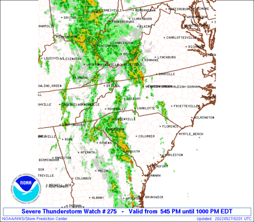
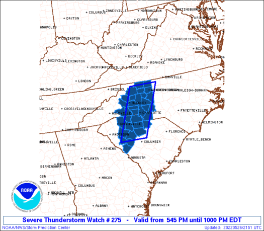
Severe Thunderstorm Watch Number 275
NWS Storm Prediction Center Norman OK
545 PM EDT Thu May 26 2022
The NWS Storm Prediction Center has issued a
* Severe Thunderstorm Watch for portions of
Western North Carolina
Western South Carolina
* Effective this Thursday afternoon and evening from 545 PM until
1000 PM EDT.
* Primary threats include...
Scattered damaging wind gusts to 65 mph possible
A tornado or two possible
SUMMARY...A mix of transient supercell structures and clusters
should spread north-northeast over the next few hours with a primary
threat of damaging winds and a brief tornado or two.
The severe thunderstorm watch area is approximately along and 40
statute miles east and west of a line from 70 miles northeast of
Hickory NC to 85 miles south southwest of Charlotte NC. For a
complete depiction of the watch see the associated watch outline
update (WOUS64 KWNS WOU5).
PRECAUTIONARY/PREPAREDNESS ACTIONS...
REMEMBER...A Severe Thunderstorm Watch means conditions are
favorable for severe thunderstorms in and close to the watch area.
Persons in these areas should be on the lookout for threatening
weather conditions and listen for later statements and possible
warnings. Severe thunderstorms can and occasionally do produce
tornadoes.
&&
AVIATION...A few severe thunderstorms with hail surface and aloft to
1 inch. Extreme turbulence and surface wind gusts to 55 knots. A few
cumulonimbi with maximum tops to 400. Mean storm motion vector
20035.
...Grams
 Note:
The Aviation Watch (SAW) product is an approximation to the watch area.
The actual watch is depicted by the shaded areas.
Note:
The Aviation Watch (SAW) product is an approximation to the watch area.
The actual watch is depicted by the shaded areas.
   SAW5
   WW 275 SEVERE TSTM NC SC 262145Z - 270200Z
   AXIS..40 STATUTE MILES EAST AND WEST OF LINE..
   70NE HKY/HICKORY NC/ - 85SSW CLT/CHARLOTTE NC/
   ..AVIATION COORDS.. 35NM E/W /34NW GSO - 27WNW CAE/
   HAIL SURFACE AND ALOFT..1 INCH. WIND GUSTS..55 KNOTS.
   MAX TOPS TO 400. MEAN STORM MOTION VECTOR 20035.

   LAT...LON 36437976 34088082 34088222 36438121

   THIS IS AN APPROXIMATION TO THE WATCH AREA.  FOR A
   COMPLETE DEPICTION OF THE WATCH SEE WOUS64 KWNS
   FOR WOU5.
Watch 275 Status Report Messages:
STATUS REPORT #2 ON WW 275

VALID 270055Z - 270140Z

SEVERE WEATHER THREAT CONTINUES RIGHT OF A LINE FROM 35 NNW AGS
TO 35 SSE SPA TO 10 WNW CLT TO 30 ENE HKY TO 30 SSW PSK.

FOR ADDITIONAL INFORMATION SEE MESOSCALE DISCUSSION 931

..JEWELL..05/27/22

ATTN...WFO...GSP...RAH...RNK...CAE...

&&

STATUS REPORT FOR WS 275

SEVERE WEATHER THREAT CONTINUES FOR THE FOLLOWING AREAS

NCC025-035-057-059-067-071-097-109-119-159-167-169-171-179-197-
270140-

NC
.    NORTH CAROLINA COUNTIES INCLUDED ARE

CABARRUS	     CATAWBA		 DAVIDSON
DAVIE		     FORSYTH		 GASTON
IREDELL 	     LINCOLN		 MECKLENBURG
ROWAN		     STANLY		 STOKES
SURRY		     UNION		 YADKIN
$$


SCC023-037-039-057-071-081-087-091-270140-

SC
.    SOUTH CAROLINA COUNTIES INCLUDED ARE

CHESTER 	     EDGEFIELD		 FAIRFIELD
LANCASTER	     NEWBERRY		 SALUDA
UNION		     YORK
$$


THE WATCH STATUS MESSAGE IS FOR GUIDANCE PURPOSES ONLY.  PLEASE
REFER TO WATCH COUNTY NOTIFICATION STATEMENTS FOR OFFICIAL
INFORMATION ON COUNTIES...INDEPENDENT CITIES AND MARINE ZONES
CLEARED FROM SEVERE THUNDERSTORM AND TORNADO WATCHES.
$$

STATUS REPORT #1 ON WW 275

VALID 262335Z - 270040Z

THE SEVERE WEATHER THREAT CONTINUES ACROSS THE ENTIRE WATCH AREA.

..JEWELL..05/26/22

ATTN...WFO...GSP...RAH...RNK...CAE...

&&

STATUS REPORT FOR WS 275

SEVERE WEATHER THREAT CONTINUES FOR THE FOLLOWING AREAS

NCC003-023-025-027-035-045-057-059-067-071-097-109-119-159-161-
167-169-171-179-193-197-270040-

NC
.    NORTH CAROLINA COUNTIES INCLUDED ARE

ALEXANDER	     BURKE		 CABARRUS
CALDWELL	     CATAWBA		 CLEVELAND
DAVIDSON	     DAVIE		 FORSYTH
GASTON		     IREDELL		 LINCOLN
MECKLENBURG	     ROWAN		 RUTHERFORD
STANLY		     STOKES		 SURRY
UNION		     WILKES		 YADKIN
$$


SCC021-023-037-039-047-057-059-071-081-083-087-091-270040-

SC
.    SOUTH CAROLINA COUNTIES INCLUDED ARE

CHEROKEE	     CHESTER		 EDGEFIELD
FAIRFIELD	     GREENWOOD		 LANCASTER
LAURENS 	     NEWBERRY		 SALUDA
SPARTANBURG	     UNION		 YORK
$$


THE WATCH STATUS MESSAGE IS FOR GUIDANCE PURPOSES ONLY.  PLEASE
REFER TO WATCH COUNTY NOTIFICATION STATEMENTS FOR OFFICIAL
INFORMATION ON COUNTIES...INDEPENDENT CITIES AND MARINE ZONES
CLEARED FROM SEVERE THUNDERSTORM AND TORNADO WATCHES.
$$
Note:
Click for Complete Product Text.
Tornadoes
Probability of 2 or more tornadoes
|
Low (20%)
|
Probability of 1 or more strong (EF2-EF5) tornadoes
|
Low (10%)
|
Wind
Probability of 10 or more severe wind events
|
Mod (40%)
|
Probability of 1 or more wind events > 65 knots
|
Low (10%)
|
Hail
Probability of 10 or more severe hail events
|
Low (10%)
|
Probability of 1 or more hailstones > 2 inches
|
Low (<5%)
|
Combined Severe Hail/Wind
Probability of 6 or more combined severe hail/wind events
|
Mod (60%)
|
For each watch, probabilities for particular events inside the watch
(listed above in each table) are determined by the issuing forecaster.
The "Low" category contains probability values ranging from less than 2%
to 20% (EF2-EF5 tornadoes), less than 5% to 20% (all other probabilities),
"Moderate" from 30% to 60%, and "High" from 70% to greater than 95%.
High values are bolded and lighter in color to provide awareness of
an increased threat for a particular event.


 @NWSSPC


