 Note:
The expiration time in the watch graphic is amended if the watch is
replaced, cancelled or extended.
Note:
Note:
The expiration time in the watch graphic is amended if the watch is
replaced, cancelled or extended.
Note: Click for
Watch Status Reports.
SEL6
URGENT - IMMEDIATE BROADCAST REQUESTED
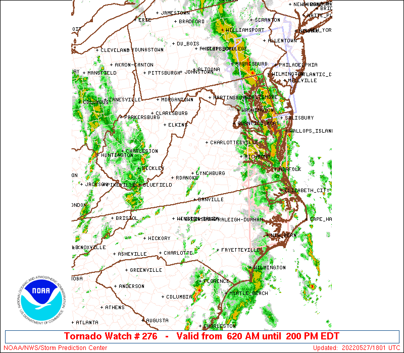
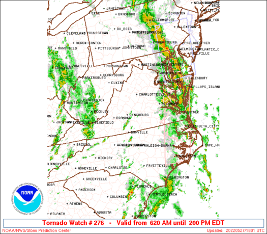
Tornado Watch Number 276
NWS Storm Prediction Center Norman OK
620 AM EDT Fri May 27 2022
The NWS Storm Prediction Center has issued a
* Tornado Watch for portions of
District Of Columbia
Central and northern Maryland
Central and northern North Carolina
Central and northern Virginia
Extreme northeastern West Virginia
Coastal Waters
* Effective this Friday morning and afternoon from 620 AM until
200 PM EDT.
* Primary threats include...
A few tornadoes possible
Scattered damaging wind gusts to 70 mph possible
SUMMARY...A gradual ramp-up of thunderstorm intensity and coverage
should continue through the remainder of the morning in a
destabilizing, moist environment, with enough shear to support
supercells and bowing segments. A few tornadoes and scattered
damaging to locally severe gusts are possible.
The tornado watch area is approximately along and 65 statute miles
east and west of a line from 25 miles southwest of Southern Pines NC
to 40 miles east northeast of Martinsburg WV. For a complete
depiction of the watch see the associated watch outline update
(WOUS64 KWNS WOU6).
PRECAUTIONARY/PREPAREDNESS ACTIONS...
REMEMBER...A Tornado Watch means conditions are favorable for
tornadoes and severe thunderstorms in and close to the watch
area. Persons in these areas should be on the lookout for
threatening weather conditions and listen for later statements
and possible warnings.
&&
AVIATION...Tornadoes and a few severe thunderstorms with hail
surface and aloft to 1 inch. Extreme turbulence and surface wind
gusts to 60 knots. A few cumulonimbi with maximum tops to 500. Mean
storm motion vector 22030.
...Edwards
   SEL6

   URGENT - IMMEDIATE BROADCAST REQUESTED
   Tornado Watch Number 276
   NWS Storm Prediction Center Norman OK
   620 AM EDT Fri May 27 2022

   The NWS Storm Prediction Center has issued a

   * Tornado Watch for portions of
     District Of Columbia
     Central and northern Maryland
     Central and northern North Carolina
     Central and northern Virginia
     Extreme northeastern West Virginia
     Coastal Waters

   * Effective this Friday morning and afternoon from 620 AM until
     200 PM EDT.

   * Primary threats include...
     A few tornadoes possible
     Scattered damaging wind gusts to 70 mph possible

   SUMMARY...A gradual ramp-up of thunderstorm intensity and coverage
   should continue through the remainder of the morning in a
   destabilizing, moist environment, with enough shear to support
   supercells and bowing segments.  A few tornadoes and scattered
   damaging to locally severe gusts are possible.

   The tornado watch area is approximately along and 65 statute miles
   east and west of a line from 25 miles southwest of Southern Pines NC
   to 40 miles east northeast of Martinsburg WV. For a complete
   depiction of the watch see the associated watch outline update
   (WOUS64 KWNS WOU6).

   PRECAUTIONARY/PREPAREDNESS ACTIONS...

   REMEMBER...A Tornado Watch means conditions are favorable for
   tornadoes and severe thunderstorms in and close to the watch
   area. Persons in these areas should be on the lookout for
   threatening weather conditions and listen for later statements
   and possible warnings.

   &&

   AVIATION...Tornadoes and a few severe thunderstorms with hail
   surface and aloft to 1 inch. Extreme turbulence and surface wind
   gusts to 60 knots. A few cumulonimbi with maximum tops to 500. Mean
   storm motion vector 22030.

   ...Edwards
 Note:
The Aviation Watch (SAW) product is an approximation to the watch area.
The actual watch is depicted by the shaded areas.
Note:
The Aviation Watch (SAW) product is an approximation to the watch area.
The actual watch is depicted by the shaded areas.
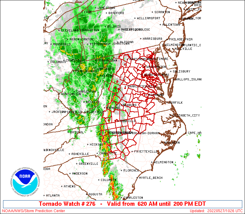
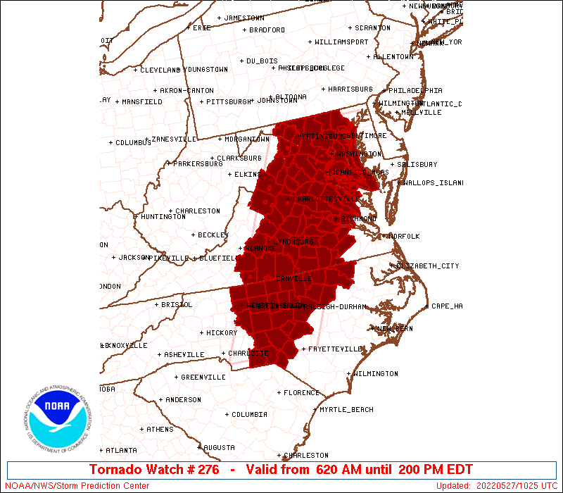
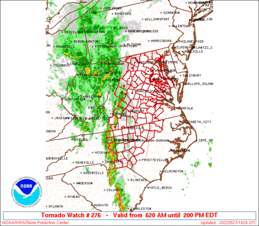
   SAW6
   WW 276 TORNADO DC MD NC VA WV CW 271020Z - 271800Z
   AXIS..65 STATUTE MILES EAST AND WEST OF LINE..
   25SW SOP/SOUTHERN PINES NC/ - 40ENE MRB/MARTINSBURG WV/
   ..AVIATION COORDS.. 55NM E/W /44N FLO - 16WNW EMI/
   HAIL SURFACE AND ALOFT..1 INCH. WIND GUSTS..60 KNOTS.
   MAX TOPS TO 500. MEAN STORM MOTION VECTOR 22030.

   LAT...LON 34968083 39617851 39617606 34967854

   THIS IS AN APPROXIMATION TO THE WATCH AREA.  FOR A
   COMPLETE DEPICTION OF THE WATCH SEE WOUS64 KWNS
   FOR WOU6.
Watch 276 Status Report Messages:
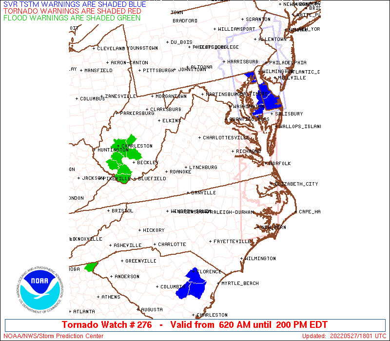
STATUS REPORT #4 ON WW 276

VALID 271740Z - 271800Z

SEVERE WEATHER THREAT CONTINUES RIGHT OF A LINE FROM 25 SSW NHK
TO 30 SSE CXY.

WW 276 WILL BE ALLOWED TO EXPIRE AT 271800Z.

..DEAN..05/27/22

ATTN...WFO...LWX...RAH...RNK...AKQ...

&&

STATUS REPORT FOR WT 276

SEVERE WEATHER THREAT CONTINUES FOR THE FOLLOWING AREAS

MDC003-009-037-271800-

MD
.    MARYLAND COUNTIES INCLUDED ARE

ANNE ARUNDEL	     CALVERT		 ST. MARYS
$$


ANZ531-532-533-534-537-542-271800-

CW

.    ADJACENT COASTAL WATERS INCLUDED ARE

CHESAPEAKE BAY FROM POOLES ISLAND TO SANDY POINT MD

CHESAPEAKE BAY FROM SANDY POINT TO NORTH BEACH MD

CHESAPEAKE BAY FROM NORTH BEACH TO DRUM POINT MD

CHESAPEAKE BAY FROM DRUM POINT MD TO SMITH POINT VA

TIDAL POTOMAC FROM COBB ISLAND MD TO SMITH POINT VA

PATUXENT RIVER TO BROOMES ISLAND MD

$$
THE WATCH STATUS MESSAGE IS FOR GUIDANCE PURPOSES ONLY.  PLEASE
REFER TO WATCH COUNTY NOTIFICATION STATEMENTS FOR OFFICIAL
INFORMATION ON COUNTIES...INDEPENDENT CITIES AND MARINE ZONES
CLEARED FROM SEVERE THUNDERSTORM AND TORNADO WATCHES.
$$

STATUS REPORT #3 ON WW 276

VALID 271620Z - 271740Z

SEVERE WEATHER THREAT CONTINUES RIGHT OF A LINE FROM 45 WSW SOP
TO 20 N RDU TO 25 ENE AVC TO 40 N RIC TO 35 WSW DCA TO 20 NNE HGR.

FOR ADDITIONAL INFORMATION SEE MESOSCALE DISCUSSION 936

..DEAN..05/27/22

ATTN...WFO...LWX...RAH...RNK...AKQ...

&&

STATUS REPORT FOR WT 276

SEVERE WEATHER THREAT CONTINUES FOR THE FOLLOWING AREAS

DCC001-271740-

DC
.    DISTRICT OF COLUMBIA COUNTIES INCLUDED ARE

DISTRICT OF COLUMBIA
$$


MDC003-005-009-013-017-021-027-031-033-037-510-271740-

MD
.    MARYLAND COUNTIES INCLUDED ARE

ANNE ARUNDEL	     BALTIMORE		 CALVERT
CARROLL 	     CHARLES		 FREDERICK
HOWARD		     MONTGOMERY 	 PRINCE GEORGES
ST. MARYS


MARYLAND INDEPENDENT CITIES INCLUDED ARE

BALTIMORE CITY
$$


NCC037-063-065-069-077-083-085-093-105-125-127-131-153-165-181-
183-185-195-271740-

NC
.    NORTH CAROLINA COUNTIES INCLUDED ARE

CHATHAM 	     DURHAM		 EDGECOMBE
FRANKLIN	     GRANVILLE		 HALIFAX
HARNETT 	     HOKE		 LEE
MOORE		     NASH		 NORTHAMPTON
RICHMOND	     SCOTLAND		 VANCE
WAKE		     WARREN		 WILSON
$$


VAC013-036-057-059-081-097-099-101-127-149-153-159-183-193-510-
570-595-600-610-670-683-685-730-271740-

VA
.    VIRGINIA COUNTIES INCLUDED ARE

ARLINGTON	     CHARLES CITY	 ESSEX
FAIRFAX 	     GREENSVILLE	 KING AND QUEEN
KING GEORGE	     KING WILLIAM	 NEW KENT
PRINCE GEORGE	     PRINCE WILLIAM	 RICHMOND
SUSSEX		     WESTMORELAND


VIRGINIA INDEPENDENT CITIES INCLUDED ARE

ALEXANDRIA	     COLONIAL HEIGHTS	 EMPORIA
FAIRFAX 	     FALLS CHURCH	 HOPEWELL
MANASSAS	     MANASSAS PARK	 PETERSBURG
$$


ANZ531-532-533-534-535-537-538-542-271740-

CW

.    ADJACENT COASTAL WATERS INCLUDED ARE

CHESAPEAKE BAY FROM POOLES ISLAND TO SANDY POINT MD

CHESAPEAKE BAY FROM SANDY POINT TO NORTH BEACH MD

CHESAPEAKE BAY FROM NORTH BEACH TO DRUM POINT MD

CHESAPEAKE BAY FROM DRUM POINT MD TO SMITH POINT VA

TIDAL POTOMAC FROM KEY BRIDGE TO INDIAN HEAD MD

TIDAL POTOMAC FROM COBB ISLAND MD TO SMITH POINT VA

PATAPSCO RIVER INCLUDING BALTIMORE HARBOR

PATUXENT RIVER TO BROOMES ISLAND MD

$$
THE WATCH STATUS MESSAGE IS FOR GUIDANCE PURPOSES ONLY.  PLEASE
REFER TO WATCH COUNTY NOTIFICATION STATEMENTS FOR OFFICIAL
INFORMATION ON COUNTIES...INDEPENDENT CITIES AND MARINE ZONES
CLEARED FROM SEVERE THUNDERSTORM AND TORNADO WATCHES.
$$

STATUS REPORT #2 ON WW 276

VALID 271505Z - 271640Z

SEVERE WEATHER THREAT CONTINUES RIGHT OF A LINE FROM 50 NW FLO TO
35 SE GSO TO 25 NE DAN TO 25 NE LYH TO 20 SSW AOO.

FOR ADDITIONAL INFORMATION SEE MESOSCALE DISCUSSION 936

..DEAN..05/27/22

ATTN...WFO...LWX...RAH...RNK...AKQ...

&&

STATUS REPORT FOR WT 276

SEVERE WEATHER THREAT CONTINUES FOR THE FOLLOWING AREAS

DCC001-271640-

DC
.    DISTRICT OF COLUMBIA COUNTIES INCLUDED ARE

DISTRICT OF COLUMBIA
$$


MDC003-005-009-013-017-021-027-031-033-037-043-510-271640-

MD
.    MARYLAND COUNTIES INCLUDED ARE

ANNE ARUNDEL	     BALTIMORE		 CALVERT
CARROLL 	     CHARLES		 FREDERICK
HOWARD		     MONTGOMERY 	 PRINCE GEORGES
ST. MARYS	     WASHINGTON


MARYLAND INDEPENDENT CITIES INCLUDED ARE

BALTIMORE CITY
$$


NCC037-063-069-077-083-085-093-105-125-127-131-135-145-153-165-
181-183-185-271640-

NC
.    NORTH CAROLINA COUNTIES INCLUDED ARE

CHATHAM 	     DURHAM		 FRANKLIN
GRANVILLE	     HALIFAX		 HARNETT
HOKE		     LEE		 MOORE
NASH		     NORTHAMPTON	 ORANGE
PERSON		     RICHMOND		 SCOTLAND
VANCE		     WAKE		 WARREN
$$


VAC003-007-011-013-025-029-033-036-037-041-043-047-049-053-057-
059-061-065-069-075-079-081-083-085-087-097-099-101-107-109-111-
113-117-127-135-137-139-145-147-149-153-157-159-177-179-183-187-
193-510-540-570-595-600-610-630-670-683-685-730-760-840-
271640-

VA
.    VIRGINIA COUNTIES INCLUDED ARE

ALBEMARLE	     AMELIA		 APPOMATTOX
ARLINGTON	     BRUNSWICK		 BUCKINGHAM
CAROLINE	     CHARLES CITY	 CHARLOTTE
CHESTERFIELD	     CLARKE		 CULPEPER
CUMBERLAND	     DINWIDDIE		 ESSEX
FAIRFAX 	     FAUQUIER		 FLUVANNA
FREDERICK	     GOOCHLAND		 GREENE
GREENSVILLE	     HALIFAX		 HANOVER
HENRICO 	     KING AND QUEEN	 KING GEORGE
KING WILLIAM	     LOUDOUN		 LOUISA
LUNENBURG	     MADISON		 MECKLENBURG
NEW KENT	     NOTTOWAY		 ORANGE
PAGE		     POWHATAN		 PRINCE EDWARD
PRINCE GEORGE	     PRINCE WILLIAM	 RAPPAHANNOCK
RICHMOND	     SPOTSYLVANIA	 STAFFORD
SUSSEX		     WARREN		 WESTMORELAND


VIRGINIA INDEPENDENT CITIES INCLUDED ARE

ALEXANDRIA	     CHARLOTTESVILLE	 COLONIAL HEIGHTS
EMPORIA 	     FAIRFAX		 FALLS CHURCH
FREDERICKSBURG	     HOPEWELL		 MANASSAS
MANASSAS PARK	     PETERSBURG 	 RICHMOND
WINCHESTER
$$


WVC003-037-065-271640-

WV
.    WEST VIRGINIA COUNTIES INCLUDED ARE

BERKELEY	     JEFFERSON		 MORGAN
$$


ANZ531-532-533-534-535-536-537-538-542-271640-

CW

.    ADJACENT COASTAL WATERS INCLUDED ARE

CHESAPEAKE BAY FROM POOLES ISLAND TO SANDY POINT MD

CHESAPEAKE BAY FROM SANDY POINT TO NORTH BEACH MD

CHESAPEAKE BAY FROM NORTH BEACH TO DRUM POINT MD

CHESAPEAKE BAY FROM DRUM POINT MD TO SMITH POINT VA

TIDAL POTOMAC FROM KEY BRIDGE TO INDIAN HEAD MD

TIDAL POTOMAC FROM INDIAN HEAD TO COBB ISLAND MD

TIDAL POTOMAC FROM COBB ISLAND MD TO SMITH POINT VA

PATAPSCO RIVER INCLUDING BALTIMORE HARBOR

PATUXENT RIVER TO BROOMES ISLAND MD

$$
THE WATCH STATUS MESSAGE IS FOR GUIDANCE PURPOSES ONLY.  PLEASE
REFER TO WATCH COUNTY NOTIFICATION STATEMENTS FOR OFFICIAL
INFORMATION ON COUNTIES...INDEPENDENT CITIES AND MARINE ZONES
CLEARED FROM SEVERE THUNDERSTORM AND TORNADO WATCHES.
$$

STATUS REPORT #1 ON WW 276

VALID 271340Z - 271440Z

THE SEVERE WEATHER THREAT CONTINUES ACROSS THE ENTIRE WATCH AREA.

..DEAN..05/27/22

ATTN...WFO...LWX...RAH...RNK...AKQ...

&&

STATUS REPORT FOR WT 276

SEVERE WEATHER THREAT CONTINUES FOR THE FOLLOWING AREAS

DCC001-271440-

DC
.    DISTRICT OF COLUMBIA COUNTIES INCLUDED ARE

DISTRICT OF COLUMBIA
$$


MDC003-005-009-013-017-021-027-031-033-037-043-510-271440-

MD
.    MARYLAND COUNTIES INCLUDED ARE

ANNE ARUNDEL	     BALTIMORE		 CALVERT
CARROLL 	     CHARLES		 FREDERICK
HOWARD		     MONTGOMERY 	 PRINCE GEORGES
ST. MARYS	     WASHINGTON


MARYLAND INDEPENDENT CITIES INCLUDED ARE

BALTIMORE CITY
$$


NCC001-007-033-037-057-063-067-069-077-081-083-085-093-105-123-
125-127-131-135-145-151-153-157-165-167-169-181-183-185-
271440-

NC
.    NORTH CAROLINA COUNTIES INCLUDED ARE

ALAMANCE	     ANSON		 CASWELL
CHATHAM 	     DAVIDSON		 DURHAM
FORSYTH 	     FRANKLIN		 GRANVILLE
GUILFORD	     HALIFAX		 HARNETT
HOKE		     LEE		 MONTGOMERY
MOORE		     NASH		 NORTHAMPTON
ORANGE		     PERSON		 RANDOLPH
RICHMOND	     ROCKINGHAM 	 SCOTLAND
STANLY		     STOKES		 VANCE
WAKE		     WARREN
$$


VAC003-007-009-011-013-015-019-025-029-031-033-036-037-041-043-
047-049-053-057-059-061-065-067-069-075-079-081-083-085-087-089-
097-099-101-107-109-111-113-117-125-127-135-137-139-143-145-147-
149-153-157-159-165-171-177-179-183-187-193-510-540-570-590-595-
600-610-630-660-670-680-683-685-690-730-760-790-820-840-
271440-

VA
.    VIRGINIA COUNTIES INCLUDED ARE

ALBEMARLE	     AMELIA		 AMHERST
APPOMATTOX	     ARLINGTON		 AUGUSTA
BEDFORD 	     BRUNSWICK		 BUCKINGHAM
CAMPBELL	     CAROLINE		 CHARLES CITY
CHARLOTTE	     CHESTERFIELD	 CLARKE
CULPEPER	     CUMBERLAND 	 DINWIDDIE
ESSEX		     FAIRFAX		 FAUQUIER
FLUVANNA	     FRANKLIN		 FREDERICK
GOOCHLAND	     GREENE		 GREENSVILLE
HALIFAX 	     HANOVER		 HENRICO
HENRY		     KING AND QUEEN	 KING GEORGE
KING WILLIAM	     LOUDOUN		 LOUISA
LUNENBURG	     MADISON		 MECKLENBURG
NELSON		     NEW KENT		 NOTTOWAY
ORANGE		     PAGE		 PITTSYLVANIA
POWHATAN	     PRINCE EDWARD	 PRINCE GEORGE
PRINCE WILLIAM	     RAPPAHANNOCK	 RICHMOND
ROCKINGHAM	     SHENANDOAH 	 SPOTSYLVANIA
STAFFORD	     SUSSEX		 WARREN
WESTMORELAND


VIRGINIA INDEPENDENT CITIES INCLUDED ARE

ALEXANDRIA	     CHARLOTTESVILLE	 COLONIAL HEIGHTS
DANVILLE	     EMPORIA		 FAIRFAX
FALLS CHURCH	     FREDERICKSBURG	 HARRISONBURG
HOPEWELL	     LYNCHBURG		 MANASSAS
MANASSAS PARK	     MARTINSVILLE	 PETERSBURG
RICHMOND	     STAUNTON		 WAYNESBORO
WINCHESTER
$$


WVC003-037-065-271440-

WV
.    WEST VIRGINIA COUNTIES INCLUDED ARE

BERKELEY	     JEFFERSON		 MORGAN
$$


ANZ531-532-533-534-535-536-537-538-542-271440-

CW

.    ADJACENT COASTAL WATERS INCLUDED ARE

CHESAPEAKE BAY FROM POOLES ISLAND TO SANDY POINT MD

CHESAPEAKE BAY FROM SANDY POINT TO NORTH BEACH MD

CHESAPEAKE BAY FROM NORTH BEACH TO DRUM POINT MD

CHESAPEAKE BAY FROM DRUM POINT MD TO SMITH POINT VA

TIDAL POTOMAC FROM KEY BRIDGE TO INDIAN HEAD MD

TIDAL POTOMAC FROM INDIAN HEAD TO COBB ISLAND MD

TIDAL POTOMAC FROM COBB ISLAND MD TO SMITH POINT VA

PATAPSCO RIVER INCLUDING BALTIMORE HARBOR

PATUXENT RIVER TO BROOMES ISLAND MD

$$
THE WATCH STATUS MESSAGE IS FOR GUIDANCE PURPOSES ONLY.  PLEASE
REFER TO WATCH COUNTY NOTIFICATION STATEMENTS FOR OFFICIAL
INFORMATION ON COUNTIES...INDEPENDENT CITIES AND MARINE ZONES
CLEARED FROM SEVERE THUNDERSTORM AND TORNADO WATCHES.
$$
Note:
Click for Complete Product Text.
Tornadoes
Probability of 2 or more tornadoes
|
Mod (50%)
|
Probability of 1 or more strong (EF2-EF5) tornadoes
|
Low (20%)
|
Wind
Probability of 10 or more severe wind events
|
Mod (50%)
|
Probability of 1 or more wind events > 65 knots
|
Low (20%)
|
Hail
Probability of 10 or more severe hail events
|
Low (10%)
|
Probability of 1 or more hailstones > 2 inches
|
Low (10%)
|
Combined Severe Hail/Wind
Probability of 6 or more combined severe hail/wind events
|
Mod (60%)
|
For each watch, probabilities for particular events inside the watch
(listed above in each table) are determined by the issuing forecaster.
The "Low" category contains probability values ranging from less than 2%
to 20% (EF2-EF5 tornadoes), less than 5% to 20% (all other probabilities),
"Moderate" from 30% to 60%, and "High" from 70% to greater than 95%.
High values are bolded and lighter in color to provide awareness of
an increased threat for a particular event.


 @NWSSPC