 Note:
The expiration time in the watch graphic is amended if the watch is
replaced, cancelled or extended.
Note:
Note:
The expiration time in the watch graphic is amended if the watch is
replaced, cancelled or extended.
Note: Click for
Watch Status Reports.
SEL7
URGENT - IMMEDIATE BROADCAST REQUESTED
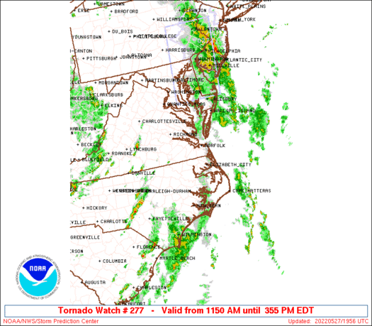
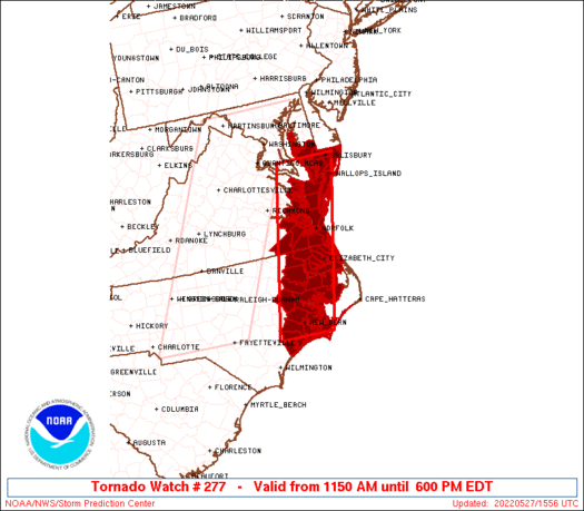
Tornado Watch Number 277
NWS Storm Prediction Center Norman OK
1150 AM EDT Fri May 27 2022
The NWS Storm Prediction Center has issued a
* Tornado Watch for portions of
Southern Maryland
Eastern North Carolina
Eastern Virginia
Coastal Waters
* Effective this Friday morning and evening from 1150 AM until
600 PM EDT.
* Primary threats include...
A couple tornadoes possible
Scattered damaging wind gusts to 65 mph possible
SUMMARY...A broken band of storms will continue to spread
eastward/northeastward through the afternoon, with additional storm
development expected from eastern North Carolina into eastern
Virginia and southern Maryland this afternoon. The storm
environment will support a mix of line segments and rotating storms
capable of producing occasional damaging gusts and a tornado or two.
The tornado watch area is approximately along and 40 statute miles
east and west of a line from 20 miles east northeast of Patuxent
River MD to 20 miles south of New Bern NC. For a complete depiction
of the watch see the associated watch outline update (WOUS64 KWNS
WOU7).
PRECAUTIONARY/PREPAREDNESS ACTIONS...
REMEMBER...A Tornado Watch means conditions are favorable for
tornadoes and severe thunderstorms in and close to the watch
area. Persons in these areas should be on the lookout for
threatening weather conditions and listen for later statements
and possible warnings.
&&
OTHER WATCH INFORMATION...CONTINUE...WW 276...
AVIATION...Tornadoes and a few severe thunderstorms with hail
surface and aloft to 0.5 inches. Extreme turbulence and surface wind
gusts to 55 knots. A few cumulonimbi with maximum tops to 500. Mean
storm motion vector 22030.
...Thompson
SEL7
URGENT - IMMEDIATE BROADCAST REQUESTED
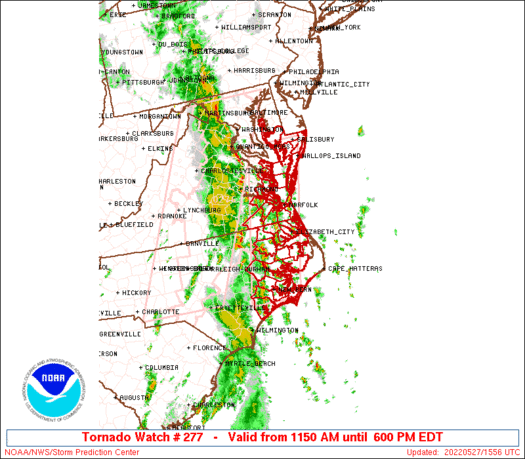
Tornado Watch Number 277
NWS Storm Prediction Center Norman OK
1150 AM EDT Fri May 27 2022
The NWS Storm Prediction Center has issued a
* Tornado Watch for portions of
Southern Maryland
Eastern North Carolina
Eastern Virginia
Coastal Waters
* Effective this Friday morning and evening from 1150 AM until
600 PM EDT.
* Primary threats include...
A couple tornadoes possible
Scattered damaging wind gusts to 65 mph possible
SUMMARY...A broken band of storms will continue to spread
eastward/northeastward through the afternoon, with additional storm
development expected from eastern North Carolina into eastern
Virginia and southern Maryland this afternoon. The storm
environment will support a mix of line segments and rotating storms
capable of producing occasional damaging gusts and a tornado or two.
The tornado watch area is approximately along and 40 statute miles
east and west of a line from 20 miles east northeast of Patuxent
River MD to 20 miles south of New Bern NC. For a complete depiction
of the watch see the associated watch outline update (WOUS64 KWNS
WOU7).
PRECAUTIONARY/PREPAREDNESS ACTIONS...
REMEMBER...A Tornado Watch means conditions are favorable for
tornadoes and severe thunderstorms in and close to the watch
area. Persons in these areas should be on the lookout for
threatening weather conditions and listen for later statements
and possible warnings.
&&
OTHER WATCH INFORMATION...CONTINUE...WW 276...
AVIATION...Tornadoes and a few severe thunderstorms with hail
surface and aloft to 0.5 inches. Extreme turbulence and surface wind
gusts to 55 knots. A few cumulonimbi with maximum tops to 500. Mean
storm motion vector 22030.
...Thompson
 Note:
The Aviation Watch (SAW) product is an approximation to the watch area.
The actual watch is depicted by the shaded areas.
Note:
The Aviation Watch (SAW) product is an approximation to the watch area.
The actual watch is depicted by the shaded areas.
   SAW7
   WW 277 TORNADO MD NC VA CW 271550Z - 272200Z
   AXIS..40 STATUTE MILES EAST AND WEST OF LINE..
   20ENE NHK/PATUXENT RIVER MD/ - 20S EWN/NEW BERN NC/
   ..AVIATION COORDS.. 35NM E/W /26W SBY - 48ENE ILM/
   HAIL SURFACE AND ALOFT..0.5 INCH. WIND GUSTS..55 KNOTS.
   MAX TOPS TO 500. MEAN STORM MOTION VECTOR 22030.

   LAT...LON 38397533 34787635 34787775 38397682

   THIS IS AN APPROXIMATION TO THE WATCH AREA.  FOR A
   COMPLETE DEPICTION OF THE WATCH SEE WOUS64 KWNS
   FOR WOU7.
Watch 277 Status Report Messages:
STATUS REPORT #3 ON WW 277

VALID 271850Z - 271940Z

SEVERE WEATHER THREAT CONTINUES RIGHT OF A LINE FROM 25 ESE ECG
TO 20 N ECG TO 20 WSW WAL TO 5 E SBY TO 70 E SBY.

..DEAN..05/27/22

ATTN...WFO...AKQ...MHX...LWX...

&&

STATUS REPORT FOR WT 277

SEVERE WEATHER THREAT CONTINUES FOR THE FOLLOWING AREAS

MDC045-047-271940-

MD
.    MARYLAND COUNTIES INCLUDED ARE

WICOMICO	     WORCESTER
$$


VAC001-131-271940-

VA
.    VIRGINIA COUNTIES INCLUDED ARE

ACCOMACK	     NORTHAMPTON
$$


THE WATCH STATUS MESSAGE IS FOR GUIDANCE PURPOSES ONLY.  PLEASE
REFER TO WATCH COUNTY NOTIFICATION STATEMENTS FOR OFFICIAL
INFORMATION ON COUNTIES...INDEPENDENT CITIES AND MARINE ZONES
CLEARED FROM SEVERE THUNDERSTORM AND TORNADO WATCHES.
$$

STATUS REPORT #2 ON WW 277

VALID 271800Z - 271940Z

SEVERE WEATHER THREAT CONTINUES RIGHT OF A LINE FROM 45 SE OAJ TO
15 NNE ORF TO 25 WNW SBY.

..DEAN..05/27/22

ATTN...WFO...AKQ...MHX...LWX...

&&

STATUS REPORT FOR WT 277

SEVERE WEATHER THREAT CONTINUES FOR THE FOLLOWING AREAS

MDC015-019-025-039-045-047-271940-

MD
.    MARYLAND COUNTIES INCLUDED ARE

CECIL		     DORCHESTER 	 HARFORD
SOMERSET	     WICOMICO		 WORCESTER
$$


NCC013-029-053-095-139-177-271940-

NC
.    NORTH CAROLINA COUNTIES INCLUDED ARE

BEAUFORT	     CAMDEN		 CURRITUCK
HYDE		     PASQUOTANK 	 TYRRELL
$$


VAC001-115-131-810-271940-

VA
.    VIRGINIA COUNTIES INCLUDED ARE

ACCOMACK	     MATHEWS		 NORTHAMPTON


VIRGINIA INDEPENDENT CITIES INCLUDED ARE

VIRGINIA BEACH
$$


AMZ131-136-230-ANZ530-531-539-540-541-543-630-631-632-633-634-
271940-

CW

.    ADJACENT COASTAL WATERS INCLUDED ARE

ALLIGATOR RIVER

PAMLICO AND PUNGO RIVERS

ALBEMARLE SOUND

CHESAPEAKE BAY NORTH OF POOLES ISLAND MD

CHESAPEAKE BAY FROM POOLES ISLAND TO SANDY POINT MD

CHESTER RIVER TO QUEENSTOWN MD

EASTERN BAY

CHOPTANK RIVER TO CAMBRIDGE MD AND THE LITTLE CHOPTANK RIVER

TANGIER SOUND AND THE INLAND WATERS SURROUNDING BLOODSWORTH
ISLAND

CHESAPEAKE BAY FROM SMITH POINT TO WINDMILL POINT VA

CHESAPEAKE BAY FROM WINDMILL POINT TO NEW POINT COMFORT VA

CHESAPEAKE BAY FROM NEW POINT COMFORT TO LITTLE CREEK VA

CURRITUCK SOUND

CHESAPEAKE BAY FROM LITTLE CREEK VA TO CAPE HENRY VA INCLUDING
THE CHESAPEAKE BAY BRIDGE TUNNEL

$$
THE WATCH STATUS MESSAGE IS FOR GUIDANCE PURPOSES ONLY.  PLEASE
REFER TO WATCH COUNTY NOTIFICATION STATEMENTS FOR OFFICIAL
INFORMATION ON COUNTIES...INDEPENDENT CITIES AND MARINE ZONES
CLEARED FROM SEVERE THUNDERSTORM AND TORNADO WATCHES.
$$

STATUS REPORT #1 ON WW 277

VALID 271620Z - 271740Z

THE SEVERE WEATHER THREAT CONTINUES ACROSS THE ENTIRE WATCH AREA.

..DEAN..05/27/22

ATTN...WFO...AKQ...MHX...LWX...

&&

STATUS REPORT FOR WT 277

SEVERE WEATHER THREAT CONTINUES FOR THE FOLLOWING AREAS

MDC019-039-045-047-271740-

MD
.    MARYLAND COUNTIES INCLUDED ARE

DORCHESTER	     SOMERSET		 WICOMICO
WORCESTER
$$


NCC013-015-029-031-041-049-053-073-091-095-103-117-133-137-139-
143-147-177-187-271740-

NC
.    NORTH CAROLINA COUNTIES INCLUDED ARE

BEAUFORT	     BERTIE		 CAMDEN
CARTERET	     CHOWAN		 CRAVEN
CURRITUCK	     GATES		 HERTFORD
HYDE		     JONES		 MARTIN
ONSLOW		     PAMLICO		 PASQUOTANK
PERQUIMANS	     PITT		 TYRRELL
WASHINGTON
$$


VAC001-073-093-095-103-115-119-131-133-175-181-199-550-620-650-
700-710-735-740-800-810-830-271740-

VA
.    VIRGINIA COUNTIES INCLUDED ARE

ACCOMACK	     GLOUCESTER 	 ISLE OF WIGHT
JAMES CITY	     LANCASTER		 MATHEWS
MIDDLESEX	     NORTHAMPTON	 NORTHUMBERLAND
SOUTHAMPTON	     SURRY		 YORK


VIRGINIA INDEPENDENT CITIES INCLUDED ARE

CHESAPEAKE	     FRANKLIN		 HAMPTON
NEWPORT NEWS	     NORFOLK		 POQUOSON
PORTSMOUTH	     SUFFOLK		 VIRGINIA BEACH
WILLIAMSBURG
$$


AMZ131-136-137-230-ANZ540-541-543-630-631-632-633-634-635-636-637-
638-271740-

CW

.    ADJACENT COASTAL WATERS INCLUDED ARE

ALLIGATOR RIVER

PAMLICO AND PUNGO RIVERS

NEUSE AND BAY RIVERS

ALBEMARLE SOUND

EASTERN BAY

CHOPTANK RIVER TO CAMBRIDGE MD AND THE LITTLE CHOPTANK RIVER

TANGIER SOUND AND THE INLAND WATERS SURROUNDING BLOODSWORTH
ISLAND

CHESAPEAKE BAY FROM SMITH POINT TO WINDMILL POINT VA

CHESAPEAKE BAY FROM WINDMILL POINT TO NEW POINT COMFORT VA

CHESAPEAKE BAY FROM NEW POINT COMFORT TO LITTLE CREEK VA

CURRITUCK SOUND

CHESAPEAKE BAY FROM LITTLE CREEK VA TO CAPE HENRY VA INCLUDING
THE CHESAPEAKE BAY BRIDGE TUNNEL

RAPPAHANNOCK RIVER FROM URBANNA TO WINDMILL POINT

YORK RIVER

JAMES RIVER FROM JAMESTOWN TO THE JAMES RIVER BRIDGE

JAMES RIVER FROM JAMES RIVER BRIDGE TO HAMPTON ROADS
BRIDGE-TUNNEL

$$
THE WATCH STATUS MESSAGE IS FOR GUIDANCE PURPOSES ONLY.  PLEASE
REFER TO WATCH COUNTY NOTIFICATION STATEMENTS FOR OFFICIAL
INFORMATION ON COUNTIES...INDEPENDENT CITIES AND MARINE ZONES
CLEARED FROM SEVERE THUNDERSTORM AND TORNADO WATCHES.
$$
Note:
Click for Complete Product Text.
Tornadoes
Probability of 2 or more tornadoes
|
Mod (30%)
|
Probability of 1 or more strong (EF2-EF5) tornadoes
|
Low (10%)
|
Wind
Probability of 10 or more severe wind events
|
Mod (40%)
|
Probability of 1 or more wind events > 65 knots
|
Low (20%)
|
Hail
Probability of 10 or more severe hail events
|
Low (<5%)
|
Probability of 1 or more hailstones > 2 inches
|
Low (<5%)
|
Combined Severe Hail/Wind
Probability of 6 or more combined severe hail/wind events
|
Mod (50%)
|
For each watch, probabilities for particular events inside the watch
(listed above in each table) are determined by the issuing forecaster.
The "Low" category contains probability values ranging from less than 2%
to 20% (EF2-EF5 tornadoes), less than 5% to 20% (all other probabilities),
"Moderate" from 30% to 60%, and "High" from 70% to greater than 95%.
High values are bolded and lighter in color to provide awareness of
an increased threat for a particular event.


 @NWSSPC


