 Note:
The expiration time in the watch graphic is amended if the watch is
replaced, cancelled or extended.
Note:
Note:
The expiration time in the watch graphic is amended if the watch is
replaced, cancelled or extended.
Note: Click for
Watch Status Reports.
SEL5
URGENT - IMMEDIATE BROADCAST REQUESTED
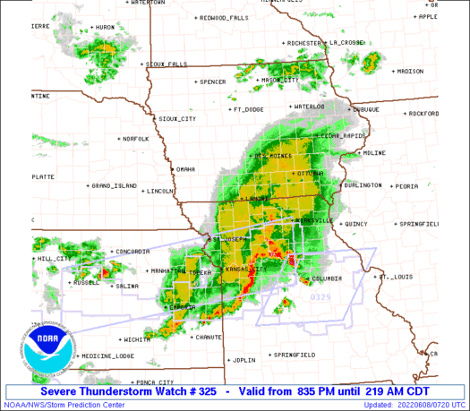
Severe Thunderstorm Watch Number 325
NWS Storm Prediction Center Norman OK
835 PM CDT Tue Jun 7 2022
The NWS Storm Prediction Center has issued a
* Severe Thunderstorm Watch for portions of
Southern Iowa
Northeast Kansas
Northern Missouri
* Effective this Tuesday night and Wednesday morning from 835 PM
until 300 AM CDT.
* Primary threats include...
Scattered large hail and isolated very large hail events to 2
inches in diameter possible
Scattered damaging wind gusts to 70 mph possible
SUMMARY...Thunderstorms capable of large hail will affect parts of
southern Iowa and northern Missouri for the next few hours.
The severe thunderstorm watch area is approximately along and 45
statute miles north and south of a line from 70 miles west of Lamoni
IA to 30 miles north northeast of Kirksville MO. For a complete
depiction of the watch see the associated watch outline update
(WOUS64 KWNS WOU5).
PRECAUTIONARY/PREPAREDNESS ACTIONS...
REMEMBER...A Severe Thunderstorm Watch means conditions are
favorable for severe thunderstorms in and close to the watch area.
Persons in these areas should be on the lookout for threatening
weather conditions and listen for later statements and possible
warnings. Severe thunderstorms can and occasionally do produce
tornadoes.
&&
OTHER WATCH INFORMATION...CONTINUE...WW 322...WW 323...WW 324...
AVIATION...A few severe thunderstorms with hail surface and aloft to
2 inches. Extreme turbulence and surface wind gusts to 60 knots. A
few cumulonimbi with maximum tops to 500. Mean storm motion vector
29030.
...Hart
 Note:
The Aviation Watch (SAW) product is an approximation to the watch area.
The actual watch is depicted by the shaded areas.
Note:
The Aviation Watch (SAW) product is an approximation to the watch area.
The actual watch is depicted by the shaded areas.
SAW5
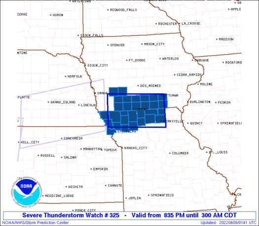
WW 325 SEVERE TSTM IA KS MO 080135Z - 080800Z
AXIS..45 STATUTE MILES NORTH AND SOUTH OF LINE..
70W LWD/LAMONI IA/ - 30NNE IRK/KIRKSVILLE MO/
..AVIATION COORDS.. 40NM N/S /40SSE OVR - 25NNE IRK/
HAIL SURFACE AND ALOFT..2 INCHES. WIND GUSTS..60 KNOTS.
MAX TOPS TO 500. MEAN STORM MOTION VECTOR 29030.
LAT...LON 41259526 41159233 39849233 39959526
THIS IS AN APPROXIMATION TO THE WATCH AREA. FOR A
COMPLETE DEPICTION OF THE WATCH SEE WOUS64 KWNS
FOR WOU5.
Watch 325 Status Report Messages:
STATUS REPORT #3 ON WW 325

VALID 080445Z - 080540Z

THE SEVERE WEATHER THREAT CONTINUES ACROSS THE ENTIRE WATCH AREA.

..SPC..06/08/22

ATTN...WFO...DMX...EAX...

&&

STATUS REPORT FOR WS 325

SEVERE WEATHER THREAT CONTINUES FOR THE FOLLOWING AREAS

IAC003-007-039-051-053-117-135-159-173-175-179-185-080540-

IA
.    IOWA COUNTIES INCLUDED ARE

ADAMS		     APPANOOSE		 CLARKE
DAVIS		     DECATUR		 LUCAS
MONROE		     RINGGOLD		 TAYLOR
UNION		     WAPELLO		 WAYNE
$$


KSC043-080540-

KS
.    KANSAS COUNTIES INCLUDED ARE

DONIPHAN
$$


MOC001-003-005-061-063-075-079-081-087-129-147-171-197-211-227-
080540-

MO
.    MISSOURI COUNTIES INCLUDED ARE

ADAIR		     ANDREW		 ATCHISON
DAVIESS 	     DEKALB		 GENTRY
GRUNDY		     HARRISON		 HOLT
MERCER		     NODAWAY		 PUTNAM
SCHUYLER	     SULLIVAN		 WORTH
$$


THE WATCH STATUS MESSAGE IS FOR GUIDANCE PURPOSES ONLY.  PLEASE
REFER TO WATCH COUNTY NOTIFICATION STATEMENTS FOR OFFICIAL
INFORMATION ON COUNTIES...INDEPENDENT CITIES AND MARINE ZONES
CLEARED FROM SEVERE THUNDERSTORM AND TORNADO WATCHES.
$$

STATUS REPORT #2 ON WW 325

VALID 080350Z - 080440Z

SEVERE WEATHER THREAT CONTINUES RIGHT OF A LINE FROM 10 ENE SDA
TO 35 SW DSM.

..SPC..06/08/22

ATTN...WFO...DMX...EAX...

&&

STATUS REPORT FOR WS 325

SEVERE WEATHER THREAT CONTINUES FOR THE FOLLOWING AREAS

IAC003-007-039-051-053-117-135-159-173-175-179-185-080440-

IA
.    IOWA COUNTIES INCLUDED ARE

ADAMS		     APPANOOSE		 CLARKE
DAVIS		     DECATUR		 LUCAS
MONROE		     RINGGOLD		 TAYLOR
UNION		     WAPELLO		 WAYNE
$$


KSC043-080440-

KS
.    KANSAS COUNTIES INCLUDED ARE

DONIPHAN
$$


MOC001-003-005-061-063-075-079-081-087-129-147-171-197-211-227-
080440-

MO
.    MISSOURI COUNTIES INCLUDED ARE

ADAIR		     ANDREW		 ATCHISON
DAVIESS 	     DEKALB		 GENTRY
GRUNDY		     HARRISON		 HOLT
MERCER		     NODAWAY		 PUTNAM
SCHUYLER	     SULLIVAN		 WORTH
$$


THE WATCH STATUS MESSAGE IS FOR GUIDANCE PURPOSES ONLY.  PLEASE
REFER TO WATCH COUNTY NOTIFICATION STATEMENTS FOR OFFICIAL
INFORMATION ON COUNTIES...INDEPENDENT CITIES AND MARINE ZONES
CLEARED FROM SEVERE THUNDERSTORM AND TORNADO WATCHES.
$$

STATUS REPORT #1 ON WW 325

VALID 080235Z - 080340Z

THE SEVERE WEATHER THREAT CONTINUES ACROSS THE ENTIRE WATCH AREA.

..SPC..06/08/22

ATTN...WFO...DMX...EAX...

&&

STATUS REPORT FOR WS 325

SEVERE WEATHER THREAT CONTINUES FOR THE FOLLOWING AREAS

IAC001-003-007-029-039-051-053-117-135-159-173-175-179-185-
080340-

IA
.    IOWA COUNTIES INCLUDED ARE

ADAIR		     ADAMS		 APPANOOSE
CASS		     CLARKE		 DAVIS
DECATUR 	     LUCAS		 MONROE
RINGGOLD	     TAYLOR		 UNION
WAPELLO 	     WAYNE
$$


KSC043-080340-

KS
.    KANSAS COUNTIES INCLUDED ARE

DONIPHAN
$$


MOC001-003-005-061-063-075-079-081-087-129-147-171-197-211-227-
080340-

MO
.    MISSOURI COUNTIES INCLUDED ARE

ADAIR		     ANDREW		 ATCHISON
DAVIESS 	     DEKALB		 GENTRY
GRUNDY		     HARRISON		 HOLT
MERCER		     NODAWAY		 PUTNAM
SCHUYLER	     SULLIVAN		 WORTH
$$


THE WATCH STATUS MESSAGE IS FOR GUIDANCE PURPOSES ONLY.  PLEASE
REFER TO WATCH COUNTY NOTIFICATION STATEMENTS FOR OFFICIAL
INFORMATION ON COUNTIES...INDEPENDENT CITIES AND MARINE ZONES
CLEARED FROM SEVERE THUNDERSTORM AND TORNADO WATCHES.
$$
Note:
Click for Complete Product Text.
Tornadoes
Probability of 2 or more tornadoes
|
Low (10%)
|
Probability of 1 or more strong (EF2-EF5) tornadoes
|
Low (<2%)
|
Wind
Probability of 10 or more severe wind events
|
Mod (40%)
|
Probability of 1 or more wind events > 65 knots
|
Low (20%)
|
Hail
Probability of 10 or more severe hail events
|
Mod (40%)
|
Probability of 1 or more hailstones > 2 inches
|
Mod (30%)
|
Combined Severe Hail/Wind
Probability of 6 or more combined severe hail/wind events
|
High (70%)
|
For each watch, probabilities for particular events inside the watch
(listed above in each table) are determined by the issuing forecaster.
The "Low" category contains probability values ranging from less than 2%
to 20% (EF2-EF5 tornadoes), less than 5% to 20% (all other probabilities),
"Moderate" from 30% to 60%, and "High" from 70% to greater than 95%.
High values are bolded and lighter in color to provide awareness of
an increased threat for a particular event.


 @NWSSPC


