 Note:
The expiration time in the watch graphic is amended if the watch is
replaced, cancelled or extended.
Note:
Note:
The expiration time in the watch graphic is amended if the watch is
replaced, cancelled or extended.
Note: Click for
Watch Status Reports.
SEL9
URGENT - IMMEDIATE BROADCAST REQUESTED
Severe Thunderstorm Watch Number 359
NWS Storm Prediction Center Norman OK
730 PM EDT Mon Jun 13 2022
The NWS Storm Prediction Center has issued a
* Severe Thunderstorm Watch for portions of
Extreme northeast Kentucky
Southeast Ohio
Extreme western Virginia
West Virginia
* Effective this Monday night and Tuesday morning from 730 PM
until 100 AM EDT.
* Primary threats include...
Scattered damaging wind gusts to 70 mph likely
Isolated large hail events to 1 inch in diameter possible
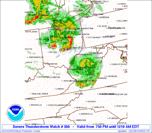
SUMMARY...An ongoing convective system in southern Ohio is expected
to persist for the next several hours while moving
east-southeastward into West Virginia. The strongest updrafts could
produce isolated large hail near 1 inch in diameter, but the main
threat will be damaging outflow winds of 60-70 mph.
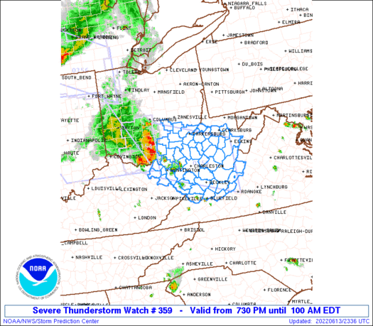
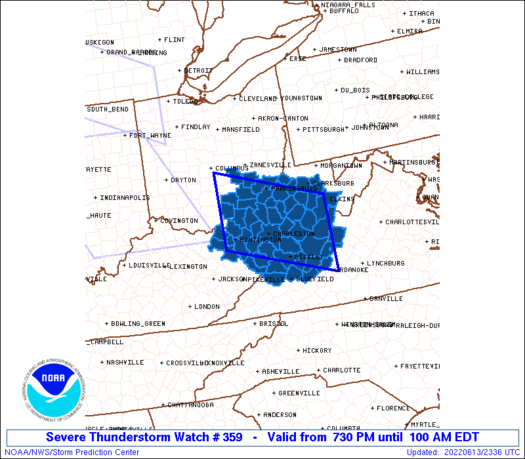
The severe thunderstorm watch area is approximately along and 60
statute miles north and south of a line from 35 miles west southwest
of Athens OH to 35 miles northeast of White Sulphur Springs WV. For
a complete depiction of the watch see the associated watch outline
update (WOUS64 KWNS WOU9).
PRECAUTIONARY/PREPAREDNESS ACTIONS...
REMEMBER...A Severe Thunderstorm Watch means conditions are
favorable for severe thunderstorms in and close to the watch area.
Persons in these areas should be on the lookout for threatening
weather conditions and listen for later statements and possible
warnings. Severe thunderstorms can and occasionally do produce
tornadoes.
&&
OTHER WATCH INFORMATION...CONTINUE...WW 354...WW 355...WW
356...WW 357...WW 358...
AVIATION...A few severe thunderstorms with hail surface and aloft to
1 inch. Extreme turbulence and surface wind gusts to 60 knots. A few
cumulonimbi with maximum tops to 600. Mean storm motion vector
30040.
...Thompson
   SEL9

   URGENT - IMMEDIATE BROADCAST REQUESTED
   Severe Thunderstorm Watch Number 359
   NWS Storm Prediction Center Norman OK
   730 PM EDT Mon Jun 13 2022

   The NWS Storm Prediction Center has issued a

   * Severe Thunderstorm Watch for portions of
     Extreme northeast Kentucky
     Southeast Ohio
     Extreme western Virginia
     West Virginia

   * Effective this Monday night and Tuesday morning from 730 PM
     until 100 AM EDT.

   * Primary threats include...
     Scattered damaging wind gusts to 70 mph likely
     Isolated large hail events to 1 inch in diameter possible

   SUMMARY...An ongoing convective system in southern Ohio is expected
   to persist for the next several hours while moving
   east-southeastward into West Virginia.  The strongest updrafts could
   produce isolated large hail near 1 inch in diameter, but the main
   threat will be damaging outflow winds of 60-70 mph.

   The severe thunderstorm watch area is approximately along and 60
   statute miles north and south of a line from 35 miles west southwest
   of Athens OH to 35 miles northeast of White Sulphur Springs WV. For
   a complete depiction of the watch see the associated watch outline
   update (WOUS64 KWNS WOU9).

   PRECAUTIONARY/PREPAREDNESS ACTIONS...

   REMEMBER...A Severe Thunderstorm Watch means conditions are
   favorable for severe thunderstorms in and close to the watch area.
   Persons in these areas should be on the lookout for threatening
   weather conditions and listen for later statements and possible
   warnings. Severe thunderstorms can and occasionally do produce
   tornadoes.

   &&

   OTHER WATCH INFORMATION...CONTINUE...WW 354...WW 355...WW
   356...WW 357...WW 358...

   AVIATION...A few severe thunderstorms with hail surface and aloft to
   1 inch. Extreme turbulence and surface wind gusts to 60 knots. A few
   cumulonimbi with maximum tops to 600. Mean storm motion vector
   30040.

   ...Thompson
 Note:
The Aviation Watch (SAW) product is an approximation to the watch area.
The actual watch is depicted by the shaded areas.
Note:
The Aviation Watch (SAW) product is an approximation to the watch area.
The actual watch is depicted by the shaded areas.
   SAW9
   WW 359 SEVERE TSTM KY OH VA WV 132330Z - 140500Z
   AXIS..60 STATUTE MILES NORTH AND SOUTH OF LINE..
   35WSW UNI/ATHENS OH/ - 35NE SSU/WHITE SULPHUR SPRINGS WV/
   ..AVIATION COORDS.. 50NM N/S /41WNW HNN - 48SSE EKN/
   HAIL SURFACE AND ALOFT..1 INCH. WIND GUSTS..60 KNOTS.
   MAX TOPS TO 600. MEAN STORM MOTION VECTOR 30040.

   LAT...LON 39898283 39007987 37277987 38168283

   THIS IS AN APPROXIMATION TO THE WATCH AREA.  FOR A
   COMPLETE DEPICTION OF THE WATCH SEE WOUS64 KWNS
   FOR WOU9.
Watch 359 Status Report Messages:
STATUS REPORT #3 ON WW 359

VALID 140310Z - 140440Z

SEVERE WEATHER THREAT CONTINUES RIGHT OF A LINE FROM 15 SSW BKW
TO 20 NNE EKN.

FOR ADDITIONAL INFORMATION SEE MESOSCALE DISCUSSION 1153

..WEINMAN..06/14/22

ATTN...WFO...RLX...RNK...

&&

STATUS REPORT FOR WS 359

SEVERE WEATHER THREAT CONTINUES FOR THE FOLLOWING AREAS

VAC005-017-045-071-580-140440-

VA
.    VIRGINIA COUNTIES INCLUDED ARE

ALLEGHANY	     BATH		 CRAIG
GILES


VIRGINIA INDEPENDENT CITIES INCLUDED ARE

COVINGTON
$$


WVC025-045-047-055-059-063-075-083-089-101-109-140440-

WV
.    WEST VIRGINIA COUNTIES INCLUDED ARE

GREENBRIER	     LOGAN		 MCDOWELL
MERCER		     MINGO		 MONROE
POCAHONTAS	     RANDOLPH		 SUMMERS
WEBSTER 	     WYOMING
$$


THE WATCH STATUS MESSAGE IS FOR GUIDANCE PURPOSES ONLY.  PLEASE
REFER TO WATCH COUNTY NOTIFICATION STATEMENTS FOR OFFICIAL
INFORMATION ON COUNTIES...INDEPENDENT CITIES AND MARINE ZONES
CLEARED FROM SEVERE THUNDERSTORM AND TORNADO WATCHES.
$$

STATUS REPORT #2 ON WW 359

VALID 140150Z - 140240Z

SEVERE WEATHER THREAT CONTINUES RIGHT OF A LINE FROM 50 NW HTS TO
25 NNE HTS TO 20 SE UNI TO 20 ESE CMH.

..WEINMAN..06/14/22

ATTN...WFO...RLX...RNK...

&&

STATUS REPORT FOR WS 359

SEVERE WEATHER THREAT CONTINUES FOR THE FOLLOWING AREAS

KYC019-043-089-127-140240-

KY
.    KENTUCKY COUNTIES INCLUDED ARE

BOYD		     CARTER		 GREENUP
LAWRENCE
$$


OHC009-115-167-140240-

OH
.    OHIO COUNTIES INCLUDED ARE

ATHENS		     MORGAN		 WASHINGTON
$$


VAC005-017-045-071-580-140240-

VA
.    VIRGINIA COUNTIES INCLUDED ARE

ALLEGHANY	     BATH		 CRAIG
GILES


VIRGINIA INDEPENDENT CITIES INCLUDED ARE

COVINGTON
$$


WVC001-005-007-011-013-015-017-019-021-025-033-035-039-041-043-
045-047-055-059-063-067-073-075-079-081-083-085-087-089-091-095-
097-099-101-105-107-109-140240-

WV
.    WEST VIRGINIA COUNTIES INCLUDED ARE

BARBOUR 	     BOONE		 BRAXTON
CABELL		     CALHOUN		 CLAY
DODDRIDGE	     FAYETTE		 GILMER
GREENBRIER	     HARRISON		 JACKSON
KANAWHA 	     LEWIS		 LINCOLN
LOGAN		     MCDOWELL		 MERCER
MINGO		     MONROE		 NICHOLAS
PLEASANTS	     POCAHONTAS 	 PUTNAM
RALEIGH 	     RANDOLPH		 RITCHIE
ROANE		     SUMMERS		 TAYLOR
TYLER		     UPSHUR		 WAYNE
WEBSTER 	     WIRT		 WOOD
WYOMING
$$


THE WATCH STATUS MESSAGE IS FOR GUIDANCE PURPOSES ONLY.  PLEASE
REFER TO WATCH COUNTY NOTIFICATION STATEMENTS FOR OFFICIAL
INFORMATION ON COUNTIES...INDEPENDENT CITIES AND MARINE ZONES
CLEARED FROM SEVERE THUNDERSTORM AND TORNADO WATCHES.
$$

STATUS REPORT #1 ON WW 359

VALID 140045Z - 140140Z

SEVERE WEATHER THREAT CONTINUES RIGHT OF A LINE FROM 40 WNW HTS
TO 30 SW UNI TO 5 NW UNI TO 15 SSW CMH.

..MOORE..06/14/22

ATTN...WFO...RLX...RNK...

&&

STATUS REPORT FOR WS 359

SEVERE WEATHER THREAT CONTINUES FOR THE FOLLOWING AREAS

KYC019-043-089-127-140140-

KY
.    KENTUCKY COUNTIES INCLUDED ARE

BOYD		     CARTER		 GREENUP
LAWRENCE
$$


OHC009-053-087-105-115-127-167-140140-

OH
.    OHIO COUNTIES INCLUDED ARE

ATHENS		     GALLIA		 LAWRENCE
MEIGS		     MORGAN		 PERRY
WASHINGTON
$$


VAC005-017-045-071-580-140140-

VA
.    VIRGINIA COUNTIES INCLUDED ARE

ALLEGHANY	     BATH		 CRAIG
GILES


VIRGINIA INDEPENDENT CITIES INCLUDED ARE

COVINGTON
$$


WVC001-005-007-011-013-015-017-019-021-025-033-035-039-041-043-
045-047-053-055-059-063-067-073-075-079-081-083-085-087-089-091-
095-097-099-101-105-107-109-140140-

WV
.    WEST VIRGINIA COUNTIES INCLUDED ARE

BARBOUR 	     BOONE		 BRAXTON
CABELL		     CALHOUN		 CLAY
DODDRIDGE	     FAYETTE		 GILMER
GREENBRIER	     HARRISON		 JACKSON
KANAWHA 	     LEWIS		 LINCOLN
LOGAN		     MCDOWELL		 MASON
MERCER		     MINGO		 MONROE
NICHOLAS	     PLEASANTS		 POCAHONTAS
PUTNAM		     RALEIGH		 RANDOLPH
RITCHIE 	     ROANE		 SUMMERS
TAYLOR		     TYLER		 UPSHUR
WAYNE		     WEBSTER		 WIRT
WOOD		     WYOMING
$$


THE WATCH STATUS MESSAGE IS FOR GUIDANCE PURPOSES ONLY.  PLEASE
REFER TO WATCH COUNTY NOTIFICATION STATEMENTS FOR OFFICIAL
INFORMATION ON COUNTIES...INDEPENDENT CITIES AND MARINE ZONES
CLEARED FROM SEVERE THUNDERSTORM AND TORNADO WATCHES.
$$
Note:
Click for Complete Product Text.
Tornadoes
Probability of 2 or more tornadoes
|
Low (10%)
|
Probability of 1 or more strong (EF2-EF5) tornadoes
|
Low (<2%)
|
Wind
Probability of 10 or more severe wind events
|
High (70%)
|
Probability of 1 or more wind events > 65 knots
|
Low (10%)
|
Hail
Probability of 10 or more severe hail events
|
Low (20%)
|
Probability of 1 or more hailstones > 2 inches
|
Low (10%)
|
Combined Severe Hail/Wind
Probability of 6 or more combined severe hail/wind events
|
High (90%)
|
For each watch, probabilities for particular events inside the watch
(listed above in each table) are determined by the issuing forecaster.
The "Low" category contains probability values ranging from less than 2%
to 20% (EF2-EF5 tornadoes), less than 5% to 20% (all other probabilities),
"Moderate" from 30% to 60%, and "High" from 70% to greater than 95%.
High values are bolded and lighter in color to provide awareness of
an increased threat for a particular event.


 @NWSSPC


