 Note:
The expiration time in the watch graphic is amended if the watch is
replaced, cancelled or extended.
Note:
Note:
The expiration time in the watch graphic is amended if the watch is
replaced, cancelled or extended.
Note: Click for
Watch Status Reports.
SEL0
URGENT - IMMEDIATE BROADCAST REQUESTED
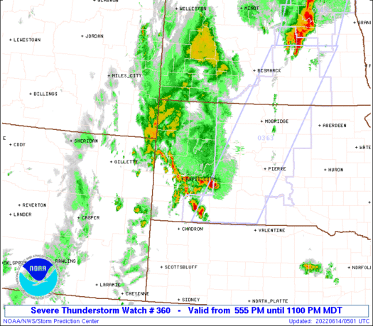
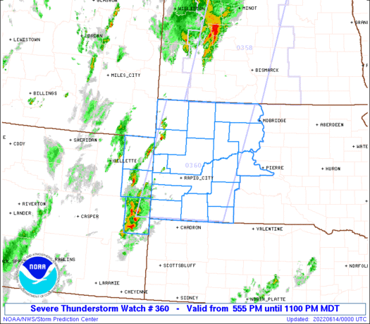
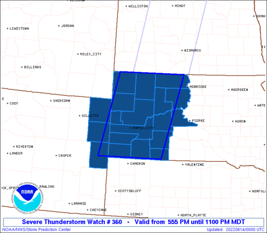
Severe Thunderstorm Watch Number 360
NWS Storm Prediction Center Norman OK
555 PM MDT Mon Jun 13 2022
The NWS Storm Prediction Center has issued a
* Severe Thunderstorm Watch for portions of
Western South Dakota
Northeast Wyoming
* Effective this Monday afternoon and evening from 555 PM until
1100 PM MDT.
* Primary threats include...
Scattered damaging winds and isolated significant gusts to 75
mph likely
Scattered large hail and isolated very large hail events to 3
inches in diameter likely
A tornado or two possible
SUMMARY...Clusters of storms are forming in eastern Wyoming, and
convection is expected to increase in coverage/intensity through
this evening into western South Dakota. The environment supports
the potential for supercells with isolated very large hail up to 3
inches in diameter, while clustering of storms in time will favor
the potential for severe outflow gusts up to 75 mph. A tornado or
two may also occur with the more persistent supercells, or with
embedded circulations in any storm clusters/line segments.
The severe thunderstorm watch area is approximately along and 75
statute miles east and west of a line from 70 miles east northeast
of Buffalo SD to 70 miles south of Rapid City SD. For a complete
depiction of the watch see the associated watch outline update
(WOUS64 KWNS WOU0).
PRECAUTIONARY/PREPAREDNESS ACTIONS...
REMEMBER...A Severe Thunderstorm Watch means conditions are
favorable for severe thunderstorms in and close to the watch area.
Persons in these areas should be on the lookout for threatening
weather conditions and listen for later statements and possible
warnings. Severe thunderstorms can and occasionally do produce
tornadoes.
&&
OTHER WATCH INFORMATION...CONTINUE...WW 354...WW 355...WW
356...WW 357...WW 358...WW 359...
AVIATION...A few severe thunderstorms with hail surface and aloft to
3 inches. Extreme turbulence and surface wind gusts to 65 knots. A
few cumulonimbi with maximum tops to 550. Mean storm motion vector
23035.
...Thompson
   SEL0

   URGENT - IMMEDIATE BROADCAST REQUESTED
   Severe Thunderstorm Watch Number 360
   NWS Storm Prediction Center Norman OK
   555 PM MDT Mon Jun 13 2022

   The NWS Storm Prediction Center has issued a

   * Severe Thunderstorm Watch for portions of
     Western South Dakota
     Northeast Wyoming

   * Effective this Monday afternoon and evening from 555 PM until
     1100 PM MDT.

   * Primary threats include...
     Scattered damaging winds and isolated significant gusts to 75
       mph likely
     Scattered large hail and isolated very large hail events to 3
       inches in diameter likely
     A tornado or two possible

   SUMMARY...Clusters of storms are forming in eastern Wyoming, and
   convection is expected to increase in coverage/intensity through
   this evening into western South Dakota.  The environment supports
   the potential for supercells with isolated very large hail up to 3
   inches in diameter, while clustering of storms in time will favor
   the potential for severe outflow gusts up to 75 mph.  A tornado or
   two may also occur with the more persistent supercells, or with
   embedded circulations in any storm clusters/line segments.

   The severe thunderstorm watch area is approximately along and 75
   statute miles east and west of a line from 70 miles east northeast
   of Buffalo SD to 70 miles south of Rapid City SD. For a complete
   depiction of the watch see the associated watch outline update
   (WOUS64 KWNS WOU0).

   PRECAUTIONARY/PREPAREDNESS ACTIONS...

   REMEMBER...A Severe Thunderstorm Watch means conditions are
   favorable for severe thunderstorms in and close to the watch area.
   Persons in these areas should be on the lookout for threatening
   weather conditions and listen for later statements and possible
   warnings. Severe thunderstorms can and occasionally do produce
   tornadoes.

   &&

   OTHER WATCH INFORMATION...CONTINUE...WW 354...WW 355...WW
   356...WW 357...WW 358...WW 359...

   AVIATION...A few severe thunderstorms with hail surface and aloft to
   3 inches. Extreme turbulence and surface wind gusts to 65 knots. A
   few cumulonimbi with maximum tops to 550. Mean storm motion vector
   23035.

   ...Thompson
 Note:
The Aviation Watch (SAW) product is an approximation to the watch area.
The actual watch is depicted by the shaded areas.
Note:
The Aviation Watch (SAW) product is an approximation to the watch area.
The actual watch is depicted by the shaded areas.
   SAW0
   WW 360 SEVERE TSTM SD WY 132355Z - 140500Z
   AXIS..75 STATUTE MILES EAST AND WEST OF LINE..
   70ENE 2WX/BUFFALO SD/ - 70S RAP/RAPID CITY SD/
   ..AVIATION COORDS.. 65NM E/W /56NNW DPR - 57S RAP/
   HAIL SURFACE AND ALOFT..3 INCHES. WIND GUSTS..65 KNOTS.
   MAX TOPS TO 550. MEAN STORM MOTION VECTOR 23035.

   LAT...LON 45940061 43030157 43030453 45940373

   THIS IS AN APPROXIMATION TO THE WATCH AREA.  FOR A
   COMPLETE DEPICTION OF THE WATCH SEE WOUS64 KWNS
   FOR WOU0.
Watch 360 Status Report Messages:
STATUS REPORT #3 ON WW 360

VALID 140335Z - 140440Z

THE SEVERE WEATHER THREAT CONTINUES ACROSS THE ENTIRE WATCH AREA.

..SPC..06/14/22

ATTN...WFO...UNR...ABR...CYS...

&&

STATUS REPORT FOR WS 360

SEVERE WEATHER THREAT CONTINUES FOR THE FOLLOWING AREAS

SDC007-019-031-033-041-047-055-063-071-081-093-102-103-105-117-
137-140440-

SD
.    SOUTH DAKOTA COUNTIES INCLUDED ARE

BENNETT 	     BUTTE		 CORSON
CUSTER		     DEWEY		 FALL RIVER
HAAKON		     HARDING		 JACKSON
LAWRENCE	     MEADE		 OGLALA LAKOTA
PENNINGTON	     PERKINS		 STANLEY
ZIEBACH
$$


WYC011-027-045-140440-

WY
.    WYOMING COUNTIES INCLUDED ARE

CROOK		     NIOBRARA		 WESTON
$$


THE WATCH STATUS MESSAGE IS FOR GUIDANCE PURPOSES ONLY.  PLEASE
REFER TO WATCH COUNTY NOTIFICATION STATEMENTS FOR OFFICIAL
INFORMATION ON COUNTIES...INDEPENDENT CITIES AND MARINE ZONES
CLEARED FROM SEVERE THUNDERSTORM AND TORNADO WATCHES.
$$

STATUS REPORT #2 ON WW 360

VALID 140140Z - 140240Z

THE SEVERE WEATHER THREAT CONTINUES ACROSS THE ENTIRE WATCH AREA.

..SPC..06/14/22

ATTN...WFO...UNR...ABR...CYS...

&&

STATUS REPORT FOR WS 360

SEVERE WEATHER THREAT CONTINUES FOR THE FOLLOWING AREAS

SDC007-019-031-033-041-047-055-063-071-081-093-102-103-105-117-
137-140240-

SD
.    SOUTH DAKOTA COUNTIES INCLUDED ARE

BENNETT 	     BUTTE		 CORSON
CUSTER		     DEWEY		 FALL RIVER
HAAKON		     HARDING		 JACKSON
LAWRENCE	     MEADE		 OGLALA LAKOTA
PENNINGTON	     PERKINS		 STANLEY
ZIEBACH
$$


WYC011-027-045-140240-

WY
.    WYOMING COUNTIES INCLUDED ARE

CROOK		     NIOBRARA		 WESTON
$$


THE WATCH STATUS MESSAGE IS FOR GUIDANCE PURPOSES ONLY.  PLEASE
REFER TO WATCH COUNTY NOTIFICATION STATEMENTS FOR OFFICIAL
INFORMATION ON COUNTIES...INDEPENDENT CITIES AND MARINE ZONES
CLEARED FROM SEVERE THUNDERSTORM AND TORNADO WATCHES.
$$

STATUS REPORT #1 ON WW 360

VALID 140045Z - 140140Z

THE SEVERE WEATHER THREAT CONTINUES ACROSS THE ENTIRE WATCH AREA.

..MOORE..06/14/22

ATTN...WFO...UNR...ABR...CYS...

&&

STATUS REPORT FOR WS 360

SEVERE WEATHER THREAT CONTINUES FOR THE FOLLOWING AREAS

SDC007-019-031-033-041-047-055-063-071-081-093-102-103-105-117-
137-140140-

SD
.    SOUTH DAKOTA COUNTIES INCLUDED ARE

BENNETT 	     BUTTE		 CORSON
CUSTER		     DEWEY		 FALL RIVER
HAAKON		     HARDING		 JACKSON
LAWRENCE	     MEADE		 OGLALA LAKOTA
PENNINGTON	     PERKINS		 STANLEY
ZIEBACH
$$


WYC011-027-045-140140-

WY
.    WYOMING COUNTIES INCLUDED ARE

CROOK		     NIOBRARA		 WESTON
$$


THE WATCH STATUS MESSAGE IS FOR GUIDANCE PURPOSES ONLY.  PLEASE
REFER TO WATCH COUNTY NOTIFICATION STATEMENTS FOR OFFICIAL
INFORMATION ON COUNTIES...INDEPENDENT CITIES AND MARINE ZONES
CLEARED FROM SEVERE THUNDERSTORM AND TORNADO WATCHES.
$$
Note:
Click for Complete Product Text.
Tornadoes
Probability of 2 or more tornadoes
|
Low (20%)
|
Probability of 1 or more strong (EF2-EF5) tornadoes
|
Low (5%)
|
Wind
Probability of 10 or more severe wind events
|
Mod (60%)
|
Probability of 1 or more wind events > 65 knots
|
Mod (60%)
|
Hail
Probability of 10 or more severe hail events
|
Mod (60%)
|
Probability of 1 or more hailstones > 2 inches
|
Mod (60%)
|
Combined Severe Hail/Wind
Probability of 6 or more combined severe hail/wind events
|
High (>95%)
|
For each watch, probabilities for particular events inside the watch
(listed above in each table) are determined by the issuing forecaster.
The "Low" category contains probability values ranging from less than 2%
to 20% (EF2-EF5 tornadoes), less than 5% to 20% (all other probabilities),
"Moderate" from 30% to 60%, and "High" from 70% to greater than 95%.
High values are bolded and lighter in color to provide awareness of
an increased threat for a particular event.


 @NWSSPC


