 Note:
The expiration time in the watch graphic is amended if the watch is
replaced, cancelled or extended.
Note:
Note:
The expiration time in the watch graphic is amended if the watch is
replaced, cancelled or extended.
Note: Click for
Watch Status Reports.
SEL4
URGENT - IMMEDIATE BROADCAST REQUESTED
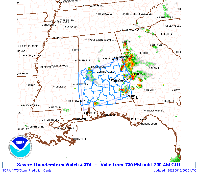
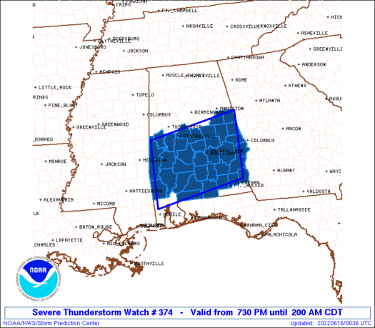
Severe Thunderstorm Watch Number 374
NWS Storm Prediction Center Norman OK
730 PM CDT Wed Jun 15 2022
The NWS Storm Prediction Center has issued a
* Severe Thunderstorm Watch for portions of
Southern Alabama
* Effective this Wednesday night and Thursday morning from 730 PM
until 200 AM CDT.
* Primary threats include...
Scattered damaging wind gusts to 70 mph likely
Scattered large hail and isolated very large hail events to 2
inches in diameter possible
SUMMARY...Severe thunderstorms will move west across the watch area
this evening posing a risk for damaging wind gusts and isolated
large hail.
The severe thunderstorm watch area is approximately along and 70
statute miles north and south of a line from 15 miles southeast of
Auburn AL to 80 miles west northwest of Evergreen AL. For a complete
depiction of the watch see the associated watch outline update
(WOUS64 KWNS WOU4).
PRECAUTIONARY/PREPAREDNESS ACTIONS...
REMEMBER...A Severe Thunderstorm Watch means conditions are
favorable for severe thunderstorms in and close to the watch area.
Persons in these areas should be on the lookout for threatening
weather conditions and listen for later statements and possible
warnings. Severe thunderstorms can and occasionally do produce
tornadoes.
&&
OTHER WATCH INFORMATION...CONTINUE...WW 371...WW 372...WW 373...
AVIATION...A few severe thunderstorms with hail surface and aloft to
2 inches. Extreme turbulence and surface wind gusts to 60 knots. A
few cumulonimbi with maximum tops to 500. Mean storm motion vector
09020.
...Bunting
 Note:
The Aviation Watch (SAW) product is an approximation to the watch area.
The actual watch is depicted by the shaded areas.
Note:
The Aviation Watch (SAW) product is an approximation to the watch area.
The actual watch is depicted by the shaded areas.
   SAW4
   WW 374 SEVERE TSTM AL 160030Z - 160700Z
   AXIS..70 STATUTE MILES NORTH AND SOUTH OF LINE..
   15SE AUO/AUBURN AL/ - 80WNW GZH/EVERGREEN AL/
   ..AVIATION COORDS.. 60NM N/S /36S LGC - 40SE MEI/
   HAIL SURFACE AND ALOFT..2 INCHES. WIND GUSTS..60 KNOTS.
   MAX TOPS TO 500. MEAN STORM MOTION VECTOR 09020.

   LAT...LON 31448525 30848830 32878830 33478525

   THIS IS AN APPROXIMATION TO THE WATCH AREA.  FOR A
   COMPLETE DEPICTION OF THE WATCH SEE WOUS64 KWNS
   FOR WOU4.
Watch 374 Status Report Messages:
STATUS REPORT #7 ON WW 374

VALID 160445Z - 160540Z

SEVERE WEATHER THREAT CONTINUES RIGHT OF A LINE FROM 30 SE MEI TO
25 NW GZH TO 35 SW GZH.

..KERR..06/16/22

ATTN...WFO...BMX...MOB...TAE...

&&

STATUS REPORT FOR WS 374

SEVERE WEATHER THREAT CONTINUES FOR THE FOLLOWING AREAS

ALC023-025-099-129-160540-

AL
.    ALABAMA COUNTIES INCLUDED ARE

CHOCTAW 	     CLARKE		 MONROE
WASHINGTON
$$


THE WATCH STATUS MESSAGE IS FOR GUIDANCE PURPOSES ONLY.  PLEASE
REFER TO WATCH COUNTY NOTIFICATION STATEMENTS FOR OFFICIAL
INFORMATION ON COUNTIES...INDEPENDENT CITIES AND MARINE ZONES
CLEARED FROM SEVERE THUNDERSTORM AND TORNADO WATCHES.
$$

STATUS REPORT #6 ON WW 374

VALID 160425Z - 160540Z

SEVERE WEATHER THREAT CONTINUES RIGHT OF A LINE FROM 30 SE MEI TO
15 N GZH TO 25 SSW GZH.

..KERR..06/16/22

ATTN...WFO...BMX...MOB...TAE...

&&

STATUS REPORT FOR WS 374

SEVERE WEATHER THREAT CONTINUES FOR THE FOLLOWING AREAS

ALC023-025-035-053-099-129-160540-

AL
.    ALABAMA COUNTIES INCLUDED ARE

CHOCTAW 	     CLARKE		 CONECUH
ESCAMBIA	     MONROE		 WASHINGTON
$$


THE WATCH STATUS MESSAGE IS FOR GUIDANCE PURPOSES ONLY.  PLEASE
REFER TO WATCH COUNTY NOTIFICATION STATEMENTS FOR OFFICIAL
INFORMATION ON COUNTIES...INDEPENDENT CITIES AND MARINE ZONES
CLEARED FROM SEVERE THUNDERSTORM AND TORNADO WATCHES.
$$

STATUS REPORT #5 ON WW 374

VALID 160410Z - 160540Z

SEVERE WEATHER THREAT CONTINUES RIGHT OF A LINE FROM 30 SE MEI TO
20 NE GZH TO 25 SE GZH.

..KERR..06/16/22

ATTN...WFO...BMX...MOB...TAE...

&&

STATUS REPORT FOR WS 374

SEVERE WEATHER THREAT CONTINUES FOR THE FOLLOWING AREAS

ALC013-023-025-035-053-099-129-131-160540-

AL
.    ALABAMA COUNTIES INCLUDED ARE

BUTLER		     CHOCTAW		 CLARKE
CONECUH 	     ESCAMBIA		 MONROE
WASHINGTON	     WILCOX
$$


THE WATCH STATUS MESSAGE IS FOR GUIDANCE PURPOSES ONLY.  PLEASE
REFER TO WATCH COUNTY NOTIFICATION STATEMENTS FOR OFFICIAL
INFORMATION ON COUNTIES...INDEPENDENT CITIES AND MARINE ZONES
CLEARED FROM SEVERE THUNDERSTORM AND TORNADO WATCHES.
$$

STATUS REPORT #4 ON WW 374

VALID 160355Z - 160440Z

SEVERE WEATHER THREAT CONTINUES RIGHT OF A LINE FROM 30 S BHM TO
20 NNE SEM TO 30 SSW MGM TO 25 SE GZH AND 20 ESE TCL TO 25 W SEM
TO 30 N GZH TO 30 ENE GZH TO 25 SE GZH.

..KERR..06/16/22

ATTN...WFO...BMX...MOB...TAE...

&&

STATUS REPORT FOR WS 374

SEVERE WEATHER THREAT CONTINUES FOR THE FOLLOWING AREAS

ALC013-023-025-035-053-063-065-091-099-119-129-131-160440-

AL
.    ALABAMA COUNTIES INCLUDED ARE

BUTLER		     CHOCTAW		 CLARKE
CONECUH 	     ESCAMBIA		 GREENE
HALE		     MARENGO		 MONROE
SUMTER		     WASHINGTON 	 WILCOX
$$


THE WATCH STATUS MESSAGE IS FOR GUIDANCE PURPOSES ONLY.  PLEASE
REFER TO WATCH COUNTY NOTIFICATION STATEMENTS FOR OFFICIAL
INFORMATION ON COUNTIES...INDEPENDENT CITIES AND MARINE ZONES
CLEARED FROM SEVERE THUNDERSTORM AND TORNADO WATCHES.
$$

STATUS REPORT #3 ON WW 374

VALID 160340Z - 160440Z

SEVERE WEATHER THREAT CONTINUES RIGHT OF A LINE FROM 30 S BHM TO
20 NNE SEM TO 30 SSW MGM TO 25 SE GZH.

..KERR..06/16/22

ATTN...WFO...BMX...MOB...TAE...

&&

STATUS REPORT FOR WS 374

SEVERE WEATHER THREAT CONTINUES FOR THE FOLLOWING AREAS

ALC007-013-023-025-035-047-053-063-065-091-099-105-119-129-131-
160440-

AL
.    ALABAMA COUNTIES INCLUDED ARE

BIBB		     BUTLER		 CHOCTAW
CLARKE		     CONECUH		 DALLAS
ESCAMBIA	     GREENE		 HALE
MARENGO 	     MONROE		 PERRY
SUMTER		     WASHINGTON 	 WILCOX
$$


THE WATCH STATUS MESSAGE IS FOR GUIDANCE PURPOSES ONLY.  PLEASE
REFER TO WATCH COUNTY NOTIFICATION STATEMENTS FOR OFFICIAL
INFORMATION ON COUNTIES...INDEPENDENT CITIES AND MARINE ZONES
CLEARED FROM SEVERE THUNDERSTORM AND TORNADO WATCHES.
$$

STATUS REPORT #2 ON WW 374

VALID 160335Z - 160440Z

SEVERE WEATHER THREAT CONTINUES RIGHT OF A LINE FROM 25 SSE BHM
TO 25 NNW MGM TO 10 W TOI TO 25 SE GZH.

..KERR..06/16/22

ATTN...WFO...BMX...MOB...TAE...

&&

STATUS REPORT FOR WS 374

SEVERE WEATHER THREAT CONTINUES FOR THE FOLLOWING AREAS

ALC001-007-013-021-023-025-035-041-047-053-063-065-085-091-099-
101-105-119-129-131-160440-

AL
.    ALABAMA COUNTIES INCLUDED ARE

AUTAUGA 	     BIBB		 BUTLER
CHILTON 	     CHOCTAW		 CLARKE
CONECUH 	     CRENSHAW		 DALLAS
ESCAMBIA	     GREENE		 HALE
LOWNDES 	     MARENGO		 MONROE
MONTGOMERY	     PERRY		 SUMTER
WASHINGTON	     WILCOX
$$


THE WATCH STATUS MESSAGE IS FOR GUIDANCE PURPOSES ONLY.  PLEASE
REFER TO WATCH COUNTY NOTIFICATION STATEMENTS FOR OFFICIAL
INFORMATION ON COUNTIES...INDEPENDENT CITIES AND MARINE ZONES
CLEARED FROM SEVERE THUNDERSTORM AND TORNADO WATCHES.
$$

STATUS REPORT #1 ON WW 374

VALID 160250Z - 160340Z

SEVERE WEATHER THREAT CONTINUES RIGHT OF A LINE FROM 20 SW ANB TO
15 ENE TOI TO 35 NE CEW.

FOR ADDITIONAL INFORMATION SEE MESOSCALE DISCUSSION 1186

..SQUITIERI..06/16/22

ATTN...WFO...BMX...MOB...TAE...

&&

STATUS REPORT FOR WS 374

SEVERE WEATHER THREAT CONTINUES FOR THE FOLLOWING AREAS

ALC001-007-013-021-023-025-035-037-039-041-047-051-053-055-063-
065-085-091-099-101-105-109-115-119-121-129-131-160340-

AL
.    ALABAMA COUNTIES INCLUDED ARE

AUTAUGA 	     BIBB		 BUTLER
CHILTON 	     CHOCTAW		 CLARKE
CONECUH 	     COOSA		 COVINGTON
CRENSHAW	     DALLAS		 ELMORE
ESCAMBIA	     ETOWAH		 GREENE
HALE		     LOWNDES		 MARENGO
MONROE		     MONTGOMERY 	 PERRY
PIKE		     ST. CLAIR		 SUMTER
TALLADEGA	     WASHINGTON 	 WILCOX
$$


THE WATCH STATUS MESSAGE IS FOR GUIDANCE PURPOSES ONLY.  PLEASE
REFER TO WATCH COUNTY NOTIFICATION STATEMENTS FOR OFFICIAL
INFORMATION ON COUNTIES...INDEPENDENT CITIES AND MARINE ZONES
CLEARED FROM SEVERE THUNDERSTORM AND TORNADO WATCHES.
$$
Note:
Click for Complete Product Text.
Tornadoes
Probability of 2 or more tornadoes
|
Low (<5%)
|
Probability of 1 or more strong (EF2-EF5) tornadoes
|
Low (<2%)
|
Wind
Probability of 10 or more severe wind events
|
Mod (60%)
|
Probability of 1 or more wind events > 65 knots
|
Low (20%)
|
Hail
Probability of 10 or more severe hail events
|
Mod (40%)
|
Probability of 1 or more hailstones > 2 inches
|
Mod (30%)
|
Combined Severe Hail/Wind
Probability of 6 or more combined severe hail/wind events
|
High (90%)
|
For each watch, probabilities for particular events inside the watch
(listed above in each table) are determined by the issuing forecaster.
The "Low" category contains probability values ranging from less than 2%
to 20% (EF2-EF5 tornadoes), less than 5% to 20% (all other probabilities),
"Moderate" from 30% to 60%, and "High" from 70% to greater than 95%.
High values are bolded and lighter in color to provide awareness of
an increased threat for a particular event.


 @NWSSPC